Stanley Mitchell Hut - The Alpine Club of Canada
Stanley Mitchell Hut - The Alpine Club of Canada
Stanley Mitchell Hut - The Alpine Club of Canada

You also want an ePaper? Increase the reach of your titles
YUMPU automatically turns print PDFs into web optimized ePapers that Google loves.
<strong>Alpine</strong> <strong>Club</strong> <strong>of</strong> <strong>Canada</strong> Backountry <strong>Hut</strong>s<strong>Stanley</strong> <strong>Mitchell</strong> <strong>Hut</strong>IndexBooking, Payment and Cancellation Policy ..................... 2Rates ............................................... 2Getting <strong>The</strong>re ............................................ 2Summer. ............................................ 2Winter. .............................................. 2Trailhead location. ..................................... 2Summer approach. .................................... 2Little Yoho Valley Approach .............................. 3Iceline Trail. .......................................... 3Winter approach. ...................................... 3Little Yoho Valley ...................................... 3<strong>The</strong> Yoho Traverse. .................................... 4Maps and Guidebooks ..................................... 4Map and GPS references. ............................... 4Maps. ............................................... 4Guidebooks and general interest books. .................... 5Website Links. ........................................... 5Current conditions ..................................... 5Area information. ...................................... 5Parks <strong>Canada</strong> Info ........................................ 5Wilderness Passes in National Parks. ...................... 5Vehicle Permits. ....................................... 6Maximum Group Size. .................................. 6Voluntary Hazardous Activities Registration. ................. 6What Is At the <strong>Hut</strong>. ........................................ 6Summary ............................................ 6<strong>The</strong> building and sleeping arrangements. ................... 6Capacity. ............................................ 6Kitchen. ............................................. 6Lighting. ............................................. 7Heat. ............................................... 7Tools. ............................................... 7Drinking Water. ....................................... 7Grey Water. .......................................... 7Human Waste. ........................................ 7Garbage. ............................................ 7<strong>Hut</strong> Rules ............................................... 8While at the hut:. ...................................... 8When leaving a hut:. ................................... 8Things To Do Around the <strong>Hut</strong>. ............................... 8Hiking. .............................................. 8Climbing and scrambling ................................ 8Backcountry Skiing. .................................... 9Ice climbing. .......................................... 9History. ................................................. 9STanley <strong>Mitchell</strong> <strong>Hut</strong> by Audrey WheelerPage 1
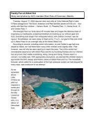
<strong>Stanley</strong> <strong>Mitchell</strong> <strong>Alpine</strong> <strong>Club</strong> <strong>Hut</strong> <strong>of</strong> <strong>Canada</strong> Backountry <strong>Hut</strong>sName <strong>of</strong> <strong>Hut</strong>View the Booking, Payment and Cancellation Policies at www.alpineclub<strong>of</strong>canada.ca/facility/reservations.htmlBooking, Payment and Cancellation PolicyRatesVisit www.alpineclub<strong>of</strong>canada.ca/facility/rates.html for current hut and wilderness pass prices.Getting <strong>The</strong>re<strong>The</strong> hut sits in a small meadow not far from the base <strong>of</strong> <strong>The</strong> President, in the Little Yoho Valley, Yoho NationalPark, B.C.<strong>The</strong> following information should be used in conjunction with the correct topographic map (maps are listed below).SummerTrailhead location:Hiking distance:Elevation gain:Approximate time:21 km west <strong>of</strong> Lake Louise, AB / 3.7 km east <strong>of</strong> Field, BC11 km / 7 miles520 m / 1700 ft3-4 hoursWinterTrailhead location:Skiing distance:Elevation gain:Approximate time:21 km west <strong>of</strong> Lake Louise, AB / 3.7 km east <strong>of</strong> Field, BC23 km675 m / 2200 ftFull day (longer if you are breaking trail), many people split the trip into 2 daysTrailhead locationIn summer, the Little Yoho Valley trailhead is located on the north side <strong>of</strong> the Trans-<strong>Canada</strong> Highway, 21 km west<strong>of</strong> Lake Louise, Alberta and 3.7 km east <strong>of</strong> Field, BC. <strong>The</strong> turn-<strong>of</strong>f to the trailhead is signed as “Takakkaw Falls” onthe highway. Follow the Yoho Valley Road to the Takakkaw Falls parking lot (13 km from the highway). Park at themost northerly point (closest to the Parks <strong>Canada</strong> campground).In winter, the Little Yoho Valley trailhead is located on the north side <strong>of</strong> the Trans-<strong>Canada</strong> Highway, 21 km west <strong>of</strong>Lake Louise, Alberta and 3.7 km east <strong>of</strong> Field, BC. <strong>The</strong> turn-<strong>of</strong>f to the trailhead is signed as “Takakkaw Falls” onthe highway. Follow the Yoho Valley Road for approximately 1 km and park at the locked gate.Summer approach<strong>The</strong> two common approaches to the <strong>Stanley</strong> <strong>Mitchell</strong> <strong>Hut</strong> are the Little Yoho Valley Trail and the Iceline Trail.Both originate at the Takakkaw Falls parking lot and follow well-developed National Park trail systems. It is morecommon to approach the hut on the former trail, and to hike the Iceline on the descent, to avoid the immediategruelling uphill <strong>of</strong> this trail. Descending the Iceline allows you to hike toward, rather than away from, thespectacular scenery surrounding the trail. You will end up about 1 km from your car if you approach the hut on theLittle Yoho Valley trail and descend the Iceline trail.Little Yoho Valley ApproachThis is the most common way <strong>of</strong> getting to the hut. <strong>The</strong> trails are well developed and maintained, the route is wellgraded, and (including a few short optional diversions), very scenic.Back to IndexPage 2
<strong>Stanley</strong> <strong>Mitchell</strong> <strong>Alpine</strong> <strong>Club</strong> <strong>Hut</strong> <strong>of</strong> <strong>Canada</strong> Backountry <strong>Hut</strong>sName <strong>of</strong> <strong>Hut</strong>Time: <strong>The</strong> standard hiking time in the summer is three to four hours, but be prepared to add to that if you don’t doa lot <strong>of</strong> backpack ing or if you have all <strong>of</strong> your kids’ stuff as well as your own on your back. Many parties use thishut as one <strong>of</strong> their first backpacking trips and as an introduction to backcountry adven tures, so the time needed tohike in is <strong>of</strong>ten underestimated.Approach: Begin hiking on the Little Yoho Valley and Twin Falls trail (signed). You will pass the campgroundalmost immediately. <strong>The</strong> trail is most ly level for about the first 4 km, and begins gaining elevation after passingLaughing Falls. At Laughing Falls you will come to a trail junction which leads to Twin Falls to the right, and theLittle Yoho Valley to the left; keep left here, and hike up the switchbacks. <strong>The</strong>re is another trail junction for MarpoleLake about half a kilo metre before reaching the top <strong>of</strong> the Laughing Falls hill. Stay left on the trail which continuesto climb the hill. Half a kilometre further, and pretty much at the top <strong>of</strong> the elevation gain, you will come to anotherjunction indicating the Whaleback trail to your right, and the Little Yoho Valley to the left; go left here, and then tothe right at the next junction which is less than 100 m further. In approxi mately another 3 km you will come to anopen meadow and the <strong>Stanley</strong> <strong>Mitchell</strong> <strong>Hut</strong>.Iceline TrailThis trail provides spectacular views <strong>of</strong> Takakkaw Falls and the glaciers beyond; you can picture where the ScottDuncan hut lies north <strong>of</strong> Mt. Daly on the southern end <strong>of</strong> the Waputik Icefield. This trail is more commonly useddescending from the hut, making a great loop trail. Early in the summer, the trail can be difficult to follow and youmay need an ice axe to safely cross some <strong>of</strong> the snow slopes.Distance and Elevation Gain: From the Takakkaw Falls parking lot, the trail rises about 600 m (2,000 ft) anddescends about 100 m (330 ft) over 11 km. Most <strong>of</strong> the elevation gain takes place within the first couple <strong>of</strong>kilometres.Time: 3-5 hours is standard for this approach.Approach: Drive up the Yoho Valley Road as described above. Leave your car at the parking lot beside theWhiskey Jack Hostel, just before Takakkaw Falls. <strong>The</strong> trail starts a couple <strong>of</strong> hundred metres north <strong>of</strong> the hostel.Climb the trail up the hillside above, through the forest to the left <strong>of</strong> a giant avalanche slide path. After 1 km thereis a junc tion for a side trip to Hidden Lake to the left, and a couple <strong>of</strong> hun dred metres further, a junction for YohoPass and Lake to the left. Keep right at both <strong>of</strong> these intersections. <strong>The</strong> trail continues rising, then levels out andfollows well-developed trails on moraine on the northeast side <strong>of</strong> the President range, before drop ping down tothe Little Yoho River and the <strong>Stanley</strong> <strong>Mitchell</strong> <strong>Hut</strong>.Winter approachA summary <strong>of</strong> winter access routes is given below. This information describes the character and difficulty <strong>of</strong> theundertaking, but is inadequate for planning or carrying out the trips themselves. Please refer to Ski Trails in theCanadian Rockies, or Summits and Icefields – Ski Tours in the Canadian Rockies by Chic Scott for completeaccess information.Two routes are commonly used to access the hut in win ter: the Little Yoho Valley approach, which gives accessfrom the highway in a long one-day push, and the less com mon multi-day route across the des Poilus Glacierfrom the Wapta Icefield. Both routes are serious undertakings, and as a result this hut is used much less in thewinter than in the summer months.Little Yoho Valley<strong>The</strong> road to Takakkaw Falls is not plowed in winter, and must be skied. <strong>The</strong> first 5 km are normally trackset. Afterarriving at the Takakkaw Falls, the route follows the one taken in summer.Distance and Elevation Gain: <strong>The</strong> ascent from the highway to the hut is approximately 700 m (2,200 ft) over 23 km.Time: Allow a full day for this approach – longer if you are breaking trail. Many people split the trip into two days,with a bivouac at the campground cook shelter just past Takakkaw Falls. <strong>The</strong>re are no amenities at the shelter,other than a ro<strong>of</strong> over your head.Back to IndexPage 3
<strong>Stanley</strong> <strong>Mitchell</strong> <strong>Alpine</strong> <strong>Club</strong> <strong>Hut</strong> <strong>of</strong> <strong>Canada</strong> Backountry <strong>Hut</strong>sName <strong>of</strong> <strong>Hut</strong>Approach: <strong>The</strong> route follows the road to Takakkaw Falls and the summer hiking trail to the hut. <strong>The</strong> trail signs maybe completely under snow, and the final stretch to the hut may be difficult to follow if a trail has not been broken orif the sun goes down. <strong>The</strong> route is described in full detail by Chic Scott in Ski Trails in the Canadian Rockies andSummits and Icefields – <strong>Alpine</strong> Ski Tours in the Canadian Rockies.<strong>The</strong> Yoho TraverseThis is a major, multi-day ski tour with a couple <strong>of</strong> varia tions. You can begin at either the Bow or Peyto <strong>Hut</strong>, or theIcefield Parkway. It is possible to push through to the <strong>Stanley</strong> <strong>Mitchell</strong> <strong>Hut</strong> in a day from the Bow <strong>Hut</strong>, but mostparties camp out one night on the des Poilus Glacier. <strong>The</strong> summary description below assumes a start at the Bow<strong>Hut</strong>.Distance and Elevation Gain: <strong>The</strong>re is a net elevation loss coming <strong>of</strong>f the Wapta Icefield, but there are a lot <strong>of</strong> upsand downs along the way. From the Bow <strong>Hut</strong> you will gain about 820m (2,700 ft), and lose about 1100m (3,600 ft)over 20 km.Time: <strong>The</strong> route is sometimes done in a full day from the Bow <strong>Hut</strong>, but many par ties plan on two days. A night outshould be planned for, even if not anticipated.Approach: <strong>The</strong> route crosses the Wapta Icefield to the west through the Rhondda - Mt. Gordon Pass and acrossthe southeast slopes <strong>of</strong> Mt. Collie before descending south onto the des Poilus Glacier. You will pass IsolatedPeak on its east side, and descend its south slopes to the hut. This route is described in detail in Chic Scott’sSummits and Icefields – <strong>Alpine</strong> Ski Tours in the Canadian Rockies and Ski Trails in the Canadian Rockies.Maps and GuidebooksAll <strong>of</strong> the following books and maps can be purchased through the ACC <strong>of</strong>fice or online through the ACC on-linestore.Map and GPS referencesMap reference: 82N/10 (Blaeberry River)Grid reference: 303081GPS coordinates: 51°31’ 36”-116°33’ 48” NAD83 11U 530293 5708485<strong>Hut</strong> elevation: 2,060m (6,825 feet)Maps●●Gem Trek Publishing 1:50,000 topographic map entitled “Lake Louise and Yoho”. This excellent map shows thetrails and highlights <strong>of</strong> the area.●●Four 1:50,000 Canadian Government issued standard topographic maps. <strong>The</strong> hut is found on the bottom righthand corner <strong>of</strong> map 82N/10 (Blaeberry River) at grid reference 303081, the parking lot and trailhead on the upperleft corner <strong>of</strong> 82N/8 (Lake Louise), and the middle part <strong>of</strong> the trail on the lower left corner <strong>of</strong> 82N/9 (Hector Lake).●●It is also advisable to carry 82N/7 (Golden) if you wish to climb the President and Vice President.<strong>The</strong> critical areas <strong>of</strong> the above four maps have been reproduced onto one 1:50,000 map sheet: Touring the WaptaIcefield, by Murray T<strong>of</strong>t.Guidebooks and general interest books●●Backcountry <strong>Hut</strong>s and Lodges <strong>of</strong> the Rockies and Columbias, by Jim Scott●●Canadian Rockies Trail Guide, by Patton and Robinson●●<strong>The</strong> Wonder <strong>of</strong> Yoho, by Don Beers●●Don’t Waste Your Time in the Canadian Rockies, by Kathy & Craig Copeland●●Selected <strong>Alpine</strong> Climbs in the Canadian Rockies, by Sean DoughertyBack to IndexPage 4
<strong>Stanley</strong> <strong>Mitchell</strong> <strong>Alpine</strong> <strong>Club</strong> <strong>Hut</strong> <strong>of</strong> <strong>Canada</strong> Backountry <strong>Hut</strong>s●●●●●●●●●●Name <strong>of</strong> <strong>Hut</strong>Scrambles in the Canadian Rockies, by Alan KaneWaterfall Ice Climbs in the Canadian Rockies, by Joe JosephsonSki Trails in the Canadian Rockies, by Chic ScottSummits and Icefields – Canadian Rockies, by Chic ScottHandbook <strong>of</strong> the Canadian Rockies, by Ben GaddWebsite LinksCurrent conditionsWeather: Go to www.weather.ec.gc.ca click on , then scroll down to . <strong>The</strong> weatherforecasts are updated 3 times daily.Avalanche Hazard: Go to www.avalanche.ca click on the and review the section for. <strong>The</strong> avalanche forecast for this region is kept currently updated.Area informationAvalanche Terrain Rating System (ATES): Parks <strong>Canada</strong> has developed a classification system for avalancheterrain, and has applied ratings to approximately 250 trips in the Mountain National Parks. For more information,visit www.pc.gc.ca/pn-np/ab/banff/visit/visit7a1_E.aspGoogle Earth Reference: A good overview <strong>of</strong> the trip into the <strong>Stanley</strong> <strong>Mitchell</strong> <strong>Hut</strong> can be seen on Google Earth.Go to http://earth.google.com/. You will find the hut at 51° 31’ 36” N, 116° 33’ 48” W.1:50,000 Topographic Map: <strong>The</strong> Canadian Government <strong>of</strong>fers free downloads <strong>of</strong> their regular 1:50,000 topomaps. <strong>The</strong> map files are large (25 MB) and take a few minutes to download. You will find this service at:http://www.geogratis.gc.ca/geogratis/en/product/search.do?id=10119. Perform your search by selecting “NTSMapsheet”, and enter 082N10. Next, press “Search” under “Search Options” (without changing any <strong>of</strong> theinformation in “Search Options”). Select 082N10 from the options and download it.1:50,000 Topo Map: Area specific version – YellowMaps.com <strong>of</strong>fers access to the Canadian Governmentmaps, but in smaller, area-specific versions. You will find the <strong>Stanley</strong> <strong>Mitchell</strong> <strong>Hut</strong> and area athttp://yellowmaps.com/topo/_emeraldlake_bc/index2.htmParks <strong>Canada</strong> InfoWilderness Passes in National ParksBanff, Jasper, Kootenay, Yoho, and Glacier National Parks collect a fee for backcountry overnight use in theParks. <strong>The</strong> fees collected from the wilderness passes go towards maintaining trails, supplying the voluntaryregistration service, avalanche forecasting, backcountry bridge-building, etc. Overnight users <strong>of</strong> the ACChuts (ages 16 and over) are required to pay this fee. A copy <strong>of</strong> the wilderness passes should be carried in thebackcountry at all times as a Parks <strong>Canada</strong> representative may ask to see pro<strong>of</strong> <strong>of</strong> purchase.We encourage you to buy these passes from the ACC, as 40% <strong>of</strong> the monies collected goes to aspecial huts account for our heritage huts and environmental improvements. You will be <strong>of</strong>feredthe option to purchase the pass when you make a reservation, or you can buy an annual passfrom our online store at: http://www.alpineclub<strong>of</strong>canada.ca/store/index.html. For current rates, visit:http://www.alpineclub<strong>of</strong>canada.ca/facility/rates.html.Vehicle PermitsAll vehicles stopping in a National Park must have a Park Motor Vehicle Permit. Annual or single day permits canbe purchased at most Park entrance gates and Park visitor centres.Back to IndexPage 5
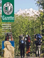
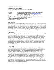
<strong>Stanley</strong> <strong>Mitchell</strong> <strong>Alpine</strong> <strong>Club</strong> <strong>Hut</strong> <strong>of</strong> <strong>Canada</strong> Backountry <strong>Hut</strong>sName <strong>of</strong> <strong>Hut</strong>Maximum Group Size<strong>The</strong> maximum group size for hiking is 10 persons. If your group is larger, you will need to split into smaller groups.Voluntary Hazardous Activities RegistrationIt is recommended that anyone participating in hazardous activities in the backcountry register with the ParkWardens. This registration is free and is the best method <strong>of</strong> ensuring that someone comes looking for you shouldthe worst happen. You can register at any Parks <strong>Canada</strong> Visitor Centre.What Is At the <strong>Hut</strong>SummaryHeating:Lighting:Cooking:Sleeping:Capacity:Drinking water:Human Waste:Dishwater:Garbage:Wood stovePropanePropane oven & range, cookware, dishes & utensilsprovidedDormitory style on thick foam mattresses26 in summer, 22 in winterFrom the creek (boil or filter)OuthouseGround sumpPack it out!<strong>The</strong> building and sleeping arrangements<strong>The</strong> <strong>Stanley</strong> <strong>Mitchell</strong> <strong>Hut</strong> is a two-storey log building. <strong>The</strong> hut consists <strong>of</strong> a large kitchen area and a living/dining room with tables, seats and a wood burning stove. <strong>The</strong> sleeping quarters have 4-inch thick coveredfoam mattresses and are in a small room on the main floor and a large upstairs l<strong>of</strong>t. Sleeping arrangements aredormitory-style, on two long bunks (bring earplugs!).Capacity<strong>The</strong> total capacity <strong>of</strong> the two huts is 24 people in the summer and 20 in the winter.Kitchen<strong>The</strong> kitchen is well supplied with dishes, cutlery, utensils, pots and pans and bake ware (including roasting pans,cookie sheets, bread pans and muffin pans). <strong>The</strong>re is a full size propane oven, as well as some two-burnerpropane stoves for cooking.Lighting<strong>The</strong> hut is lit by several propane lights. Propane is supplied by the ACC via a large outdoor tank.Heat<strong>The</strong> hut has a wood-burning stove. Firewood is stored behind the hut. Please replace all firewood you use in thehut with cut and split wood from the pile.Back to IndexPage 6
<strong>Stanley</strong> <strong>Mitchell</strong> <strong>Alpine</strong> <strong>Club</strong> <strong>Hut</strong> <strong>of</strong> <strong>Canada</strong> Backountry <strong>Hut</strong>sToolsName <strong>of</strong> <strong>Hut</strong><strong>The</strong> hut has a good supply <strong>of</strong> tools including waterbuckets, axes, saws, shovels, etc.Drinking WaterDrinking water is from a small spring-fed creek runningthrough the meadow 60m south <strong>of</strong> the hut. It isadvisable to boil or treat the water before drinking it. Inthe winter you can dig down to the creek or melt snowfor water.Grey WaterGrey water disposal is in a ground sump next to thehut. You can drain grey water directly down the sinks,but please ensure that the strainer is in place under the drain. Do not allow any food scraps (including c<strong>of</strong>feegrounds) to enter the grey water sump or it will become plugged. Please periodically empty the strainer contentsinto the fireplace. <strong>The</strong> grey water sump occasionally freezes in the winter. In this case, please dump your greywater (strained <strong>of</strong> food particles) within a three metre radius <strong>of</strong> the outhouse.Human Waste<strong>The</strong> outhouse is located 30 m west <strong>of</strong> the front door <strong>of</strong> the main hut. Do not dispose <strong>of</strong> any garbage in theouthouse.Garbage●●Burn all paper garbage and food scraps, and pack out all other garbage and unused food.●●What you need to bring●●combination lock number for the hut door (call the ACC <strong>of</strong>fice to confirm before you go to the hut)●●sleeping bag●●toilet paper●●newspaper for lighting the fire●●matches●●first aid kit●●9V battery for the smoke detector●●reservation form from the ACC (to show the custodian)●●Parks <strong>Canada</strong> overnight or annual wilderness pass (the former will be on your reservation form if you purchase itthrough the ACC).<strong>Hut</strong> RulesHere is a list <strong>of</strong> simple rules we ask that you follow in order to maximize everyone’senjoyment <strong>of</strong> the “hutexperience”.While at the hut:●●No smoking.●●Dogs are not permitted in any ACC facility (with the exception <strong>of</strong> seeing eye dogs).●●Some Parks also outlaw dogs entirely; leashed or not. Check before you go!●●If you arrive at the hut before 2:00 pm, put your belongings where they will not disturb the previous nights’occupants.●●Please be considerate <strong>of</strong> others; the hut should be quiet by 10 pm.●●Carry out all <strong>of</strong> your garbage.Back to IndexPage 7
<strong>Stanley</strong> <strong>Mitchell</strong> <strong>Alpine</strong> <strong>Club</strong> <strong>Hut</strong> <strong>of</strong> <strong>Canada</strong> Backountry <strong>Hut</strong>s●●●●●●●●●●Name <strong>of</strong> <strong>Hut</strong>Do not do personal washing in cooking pots or nearby streams - use wash basins and slop pits.Fill stoves and lanterns outside the hut and leave extra fuel outside.Clean the stoves after using them.Clean up after yourself.Follow posted instructions for care and maintenance <strong>of</strong> toilet systems so that they function properly with minimumodor and environmental impact.When leaving a hut:●●If your belongings will be in the hut after 2:00 pm, and you are not staying that night, be sure to pack everythingup and leave it out <strong>of</strong> the way in a corner so the new guests can move in.●●Leave all tools inside the hut when not being used.●●Empty all water containers and slop buckets before leaving the hut.●●Take out all leftover food as food left in the hut encourages rodents. (Other people generally won’t use it as theydon’t know how old it is.)●●Bring out damaged axes, lanterns or stoves and discharged fire extinguishers - advise the national <strong>of</strong>fice.●●Close & latch the outhouse door when leaving to keep out rodents & snow.●●Close/lock hut, replace shutters (if applicable), before leaving the hut.●●A nearly full outhouse, damage to hut & similar matters should be reported to the national <strong>of</strong>fice (you may callcollect)Please leave the hut in better condition than you found it. Thank you for your consideration in following theserules, and have a great time!Things To Do Around the <strong>Hut</strong>Hiking<strong>The</strong> hiking on established trails in the vicinity <strong>of</strong> the hut is excellent, with interesting trips back down the valleytoward Twin Falls (such as the Whaleback trail and the Marpole Lake trail) as well as up past the hut towardKiwetinok Pass. Refer to <strong>The</strong> Canadian Rockies Trail Guide, <strong>The</strong> Wonder <strong>of</strong> Yoho and Don’t Waste Your Time inthe Canadian Rockies for more information on these and other trails.Climbing and scrambling<strong>The</strong> big mountaineering objectives <strong>of</strong> the area are Mts. President and Vice President. <strong>The</strong> routes from the colbetween the two peaks are excellent moderate mountaineering challenges that see a fair number <strong>of</strong> beginnersbrought along. <strong>The</strong> Vice President also <strong>of</strong>fers a very good snow and ice route on the north face. <strong>The</strong> North Ridgeand East Face <strong>of</strong> Mt. McArthur to the northwest are also very good alpine outings. Information on these routescan be found in Selected <strong>Alpine</strong> Climbs in the Canadian Rockies, and <strong>The</strong> Rocky Mountains <strong>of</strong> <strong>Canada</strong> - South.Besides the President and Vice President, the other peaks in the area are primarily scrambling outings. Some<strong>of</strong> the most common objectives are Mt. Kerr, Mt. Polinger, Kiwetinok Peak and Isolated Peak. <strong>The</strong>re is also verygood scrambling along Whaleback Mountain. Scrambling in the Canadian Rockies contains descriptions <strong>of</strong> thescrambling routes around the <strong>Stanley</strong> <strong>Mitchell</strong> <strong>Hut</strong>.Backcountry SkiingChic Scott in Summits and Icefields – <strong>Alpine</strong> Ski Tours in the Canadian Rockies raves about the Little Yoho Valleyin the winter, referring to both the skiing ter rain and the warmth and atmosphere at the <strong>Stanley</strong> <strong>Mitchell</strong> <strong>Hut</strong>.According to Chic, the valley, with its perfect terrain, excellent snow and ski runs which end at the door <strong>of</strong> the hutis the “Gem <strong>of</strong> the Rockies”. What more needs to be said?Back to IndexPage 8
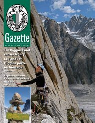
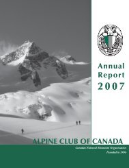
<strong>Stanley</strong> <strong>Mitchell</strong> <strong>Alpine</strong> <strong>Club</strong> <strong>Hut</strong> <strong>of</strong> <strong>Canada</strong> Backountry <strong>Hut</strong>sName <strong>of</strong> <strong>Hut</strong>It is an awfully long way to haul ice climbing gear, but if you are really keen, you will be rewarded with ascentsIce climbingHistory<strong>of</strong> the lovely “Twin Falls” (100 m, WI 4-5). Refer to Waterfall Ice Climbs in the Canadian Rockies for moreinformation.Along with A.O. Wheeler and Elizabeth Parker, <strong>Stanley</strong><strong>Mitchell</strong> was responsible for founding the <strong>Alpine</strong> <strong>Club</strong><strong>of</strong> <strong>Canada</strong> in 1906, and from 1907 to 1930 he servedas its Secretary-Treasurer. He had a great reputationas a gentleman among his fellow founders and theexecutive <strong>of</strong> the <strong>Club</strong>, as well as the members he metat the <strong>Club</strong> House in Banff. He died in 1940, shortlyafter the hut which bears his name was completed.<strong>The</strong> Little Yoho Valley has long had a reputation as anexcellent alpine climbing area as well as a magnificentskiing area. <strong>The</strong> Canadian military used the areaduring the summer <strong>of</strong> 1943 as a training site formountaineering techniques. From 1954 to the mid-70s Hans Gmoser used the hut as a base for his newski tour ing operation - a company which eventuallybecame Canadian Mountain Holidays.<strong>The</strong> hut has undergone a few renovations, but is relatively the same as it was in 1940. It is presently in excellentcondition; a comfortable facility set in beautiful meadow and mountain terrain, and a fine memorial to one <strong>of</strong> the<strong>Club</strong>’s founders.<strong>The</strong> <strong>Stanley</strong> <strong>Mitchell</strong> <strong>Hut</strong> was designated a Federal Heritage Building in 1997.Back to IndexPage 9