BIAR - AKUREYRI / Akureyri
BIAR - AKUREYRI / Akureyri
BIAR - AKUREYRI / Akureyri

Create successful ePaper yourself
Turn your PDF publications into a flip-book with our unique Google optimized e-Paper software.
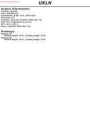
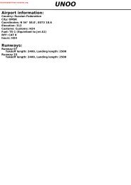
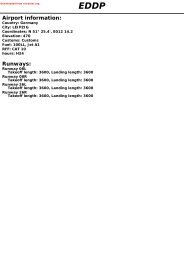
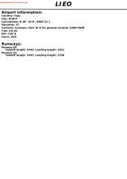
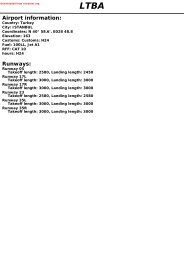
Downloaded from rutracker.orgAirport information:Country: IcelandCity: <strong>AKUREYRI</strong>Coordinates: N 65° 39.5', W 018° 04.3'Elevation: 9Customs: Customs: O/RFuel: 100LL, Jet A1RFF: CAT 5 + CAT 7 PN 10minhours: ATC: H24<strong>BIAR</strong>Runways:Runway 01Takeoff length: 2550, Landing length: 2400Runway 19Takeoff length: 2550, Landing length: 2400
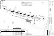
500If you like to use this charts, please, buy a subscription for nDAC.For rutracker.orgAERODROME10 - 1 07 MAY 13<strong>Akureyri</strong> TWR RAD118.2 118.7AD Elev 9 ARP: N65 39.5 W018 04.3 RFF: CAT 5. CAT 7 10min PNAD HR: H24Iceland - <strong>BIAR</strong> / AEY<strong>AKUREYRI</strong>10 - 1W018 07 W018 06 W018 05 W018 04 W018 03 W018 02 W018 0114W1305Lead-in lights: 9 LDIN FLG lightswith 700m interval, starting7196m /23608ft south of RWY 01.19190°ELEV 7010°1001LEAD-IN LIGHTS37530501300N65407873x147ftTHR CoordinatesRWY 01 N65 38.8 W018 04.2RWY 19 N65 40.0 W018 04.4Parking position coordinatesCAT B N65 39.2 W018 04.5N65 39.3 W018 04.5CAT C/D N65 39.3 W018 04.5500100TWRHangarTerminal2400x45mN65 39.2W018 04.8ELEV 6DME IEY1020380LOC IEYN6539300390285ELEV 901010°0 500 1000m1801NDB KN0 1000 2000 3000 4000ftRWY Slope TORA m/ ft LDA m/ ft ALS REDL Additional01 0 2550 / 8366 2 2400 / 7873 H-D H 3 P3.5° / 5.3° R (53 / 180), REIL 419 0 2550 / 8366 2 2400 / 7873 - H 3 P3.5°(59), REIL 52 TKOF from paved end inside RESA. 3 White. 4 Not to be used beyond 4nm from THR and more than10° either side of the CL due to obstacles. 5 Not to be used beyond 4nm from THR due to obstacles.Navtech - biar01laorg0EU OPSTAKE OFF MINIMARWYFacilities01/19RCL (day only) or RCL + REDLNIL (day only)GENERAL INFORMATION1. SPEED2. CIRCUITMAX 250kt below FL100.RWY 01 right hand circuit.RVRA B C D400m500mReverse side blankChange: MEHTTHIS CHART IS A PART OF NAVIGRAPH CHARTS AND IS INTENDED FOR FLIGHT SIMULATION USE ONLY
If you like to use this charts, please, buy a subscription for nDAC.For rutracker.orgSID RWY 01WEF 27 JUN 13 30 - 1<strong>Akureyri</strong> TWR APP RAD118.2 118.2 118.7RNAV ASKUR 1S, PERUR 1S07 MAY 13Iceland - <strong>BIAR</strong> / AEY<strong>AKUREYRI</strong>TA 7000 AD Elev 91000200030004000ARS036000N65 40.2W018 25.0ARS023500MAX 150ktN65 45.7W018 10.68.1241°2.7298°5 014°<strong>Akureyri</strong>334 ARN65 45.4W018 05.4ARS012300MAX 150ktN65 45.0W018 04.3PERURN65 26.5W018 57.620003000PERU1SPERUR 1S239°19.329.4208°3000400020001000100020003000RNP 1 RequiredCAT A and B only30 - 11000100020003000ASKUR 1SASKU1SBotn387 NBN65 19.6W018 17.60 5 10nmASKURN65 11.7W018 41.568NB62060 24071AR60171 351Navtech - biar01daorg0SID MNM Climb RouteingASKUR 1S 8% to 5000 Climb on 014° - ARS01 (MAX 150kt) - ARS02(MAX 150kt) - ARS03 - ASKUR.PERUR 1S8% to 5000Climb on 014° - ARS01 (MAX 150kt) - ARS02(MAX 150kt) - ARS03 - PERUR.AltitudesARS01 MNM 2300ARS02 MNM 3500ARS03 MNM 6000Change: NewTHIS CHART IS A PART OF NAVIGRAPH CHARTS AND IS INTENDED FOR FLIGHT SIMULATION USE ONLY
If you like to use this charts, please, buy a subscription for nDAC.For rutracker.orgSID RWY 01WEF 27 JUN 13 30 - 3<strong>Akureyri</strong> TWR APP RAD118.2 118.2 118.707 MAY 13Iceland - <strong>BIAR</strong> / AEY<strong>AKUREYRI</strong>TA 7000 AD Elev 9AKI 2B5500344°200030001000300040001000 2000AKI 2A:4200AKI 2B:2600D10.8AKID12.6 IEYHjalteyri319 HJN65 51.1W018 11.50 5 10nmDME3.8 9.8111.9 IEYN65 38.9W018 04.1359°175°AKI 2A300020001000<strong>Akureyri</strong>334 ARN65 45.4W018 05.4<strong>Akureyri</strong>D113.6 AKIOddeyri415 OEN65 45.6W018 00.3D2.3 IEYN65 41.2W018 04.7200030 - 3Navtech - biar03daorg04000300020001000171 351SID MNM Climb RouteingAltitudesAKI 2A 6% Climb on 010° - at D2.3 IEY (OE) turn left - 359° to HJ MNM 4200HJ - HJ - turn right to AKI climbing to clearedALT/FL.AKI 2B10003.6% Climb on 010° - at D2.3 IEY (OE) turn left - 359° to HJ MNM 2600HJ - HJ - 359° from HJ - intcp R344 AKI - whenpassing 5500 turn right to AKI climbing to clearedALT/FL.300071AR60Change: RenumberedTHIS CHART IS A PART OF NAVIGRAPH CHARTS AND IS INTENDED FOR FLIGHT SIMULATION USE ONLY
41000If you like to use this charts, please, buy a subscription for nDAC.For rutracker.orgSID RWY 19WEF 27 JUN 13<strong>Akureyri</strong> TWR APP RAD118.2 118.2 118.7TA 7000 AD Elev 940003000200030 - 407 MAY 13Iceland - <strong>BIAR</strong> / AEY<strong>AKUREYRI</strong>Radar monitoring on request2000100020001000DME111.9 IEYN65 38.9W018 04.1190°2.330 - 44000200052302980D11 IEY30001000740D2.5 IEY218°213° 1.8NB1A4.9BOTN 1A1.91340D4.4 IEY2560Torfur324 TON65 30.0W018 09.1300020001000Botn387 NBN65 19.6W018 17.65.23960D15 IEY0 5 10nm68NB62060 240Navtech - biar04daorg0MNM CLIMB GRADIENT:SIDBOTN 1A5% until D4.4 IEY, then 4% to 5230.RouteingClimb on 190° to D2.5 IEY - turn right (MAX 203kt) - 218° - TO -turn left - 213° - NB - continue as cleared climbing to MEAbefore acceleration.AltitudesD2.5 IEY MNM 740D4.4 IEY MNM 1340TO MNM 2560D11 IEY MNM 2980D15 IEY MNM 3960NB MNM 5230Change: RenumberedTHIS CHART IS A PART OF NAVIGRAPH CHARTS AND IS INTENDED FOR FLIGHT SIMULATION USE ONLY
300041If you like to use this charts, please, buy a subscription for nDAC.For rutracker.orgSTARWEF 14 NOV 13<strong>Akureyri</strong> APP RAD TWR118.2 118.7 118.2TL ATC AD Elev 93000100040 - 1Scaledistorted27 SEP 13Grimsey308 GRN66 31.7W017 59.0Iceland - <strong>BIAR</strong> / AEY<strong>AKUREYRI</strong>AKI 1H600030002000196° 62000R2226800G1D15AKI2330001000103°087°69002000Y14915.6065°1000D15AKI10002000 3000994000AKI 1A6100AKI 1B61003000D27 AKIBotn387 NBN65 19.6W018 17.6Hjalteyri319 HJN65 51.1W018 11.5AKI 2C6900 6400D6AKID6AKI66D6AKI9 6021°30004000030°65002000AKI 1D10006400018°1521 68201°56005600560056005600AKI 1J664005600D6AKID6AKI1PEXILD21 AKIN65 24.2W018 03.1<strong>Akureyri</strong>D113.6 AKIN65 45.6W018 00.330001000103000AKI 1G560010110560056001000D10AKID10AKI<strong>Akureyri</strong>D113.6 AKID10AKIAKI 1FAKI 1E200020001000334°G1259°288°R2301°154°5200550056002000R55400100040 - 1Navtech - biar01aaorg03000G413 065°61000 5 10nm3000300066180 360AKI55Reverse side blankChange: ALT, AKI 2C, MT, WPTHIS CHART IS A PART OF NAVIGRAPH CHARTS AND IS INTENDED FOR FLIGHT SIMULATION USE ONLY
013°6193°600030002000If you like to use this charts, please, buy a subscription for nDAC.For rutracker.orgILS RWY 01<strong>Akureyri</strong> APP RAD TWR118.2 118.7 118.250 - 107 MAY 13Iceland - <strong>BIAR</strong> / AEY<strong>AKUREYRI</strong>ILS/DME 108.9 IAL FAT 013° THR Elev 9 AD Elev 9 TL ATC TA 7000PANS OPSW018 40 W018 30 W018 20 W018 10 W018 00 W017 50 W017 40 W017 3014WCautionAdhere strictly to procedure dueOddeyri D2 to high terrain. Turbulence and415 OE IAL altimeter error may be expected.3000200010004820486046803960D2.3 IAL39004460506010nmD8.5IALILS/DME108.9 IAL10358°10003110300033702000LOC offset 2.6°3735Expect LOC fluctuationoutside D9 IAL.LOC not to be used outside10° each side of APCHcourse.DME required1000N6540N6530013°344°324055003.7Hjalteyri319 HJ358°2010°6000358°190°<strong>Akureyri</strong>D113.6 AKI<strong>Akureyri</strong>334 AR10003000PEXILD14.7 IAL2000IAFBotn387 NB68NB62060 240N652050 - 1SeeChart148001013°5.3°Proc only valid for ACFTcertified to carry outapproaches at 5.3°.D8.5IALClimb on 013° to D2 IAL ,turn left on 358° to HJ and holdat 6000 .2 If unable to reach 6000at HJ , continue on 358° andintcp R344 AKI . At 5500 turnright to AR and hold at 6000 .biar01iaip00EU OPSNavtech -nm17 16 15 14 13ACFT ILS 4.5% aA290 (280)600mB320 (307)700mC340 (331)800mDNA12 11 10 9 8 7 6 5 4 3 2 1a a aILS 3.5%ILS 3.0%470 (458) 570 (560)1400m 1500m500 (485) 600 (587)1500m 1500m520 (509) 620 (611)1600m 2100mILS 2.5%680 (671)1500m710 (698)1500m740 (722)2400mNA NA NA0TCH 83a MISAP MNM Climb Gradient. LDA 2400x457873x147ftNote: Circling NA P 3.5° / 5.3° R(53 / 180)FALSChange: ALS boxTHIS CHART IS A PART OF NAVIGRAPH CHARTS AND IS INTENDED FOR FLIGHT SIMULATION USE ONLY
If you like to use this charts, please, buy a subscription for nDAC.For rutracker.orgWEF 28 JUN 12 50 - 2INITIAL APCH LOC RWY 01 RADAR<strong>Akureyri</strong> APP RAD TWR118.2 118.7 118.229 MAY 12Iceland - <strong>BIAR</strong> / AEY<strong>AKUREYRI</strong>PANS OPS50 - 2biar02iaip00Navtech -LOC/DME 111.9 IEY FAT 038° THR Elev 9 AD Elev 9 TL ATC TA 70003000W018 40 W018 30 W018 20 W018 10 W018 00 W017 50 W017 40 W017 30DME14WOddeyri111.9 IEYDME required415 OELOCFor final APCH4820111.9 IEYsee 50-3Kristnes364 KNCaution3000NO GP560040003000LOC not to be used outside10° each side of APCHcourse.682000NB060 240SeeChart200010004290D17IEY038°4680IAFGILTUD21.8 IEYD14IEY486039601000D17IEYD14IEY4600 4200 3300nm 21 20 19 18 17 16 15 14 13 12 11 10GSROD 3.5°6280500100620120750D3.7 IEY125060D4.7Torfur IEY324 TO D9D9.2 IEYIEY33703.5°2000038°021°D11IEYD11 D9.2IEY IEYTO 1D9IEY96500833101300710358°Botn387 NBD3.7 IEYKN2 D4.7IEY654001°D20.2 IEY201°IAF3000300020002 RAD vectoring starts at D4.7 IEY3IEY Climb on 038° to Marker, turn left(MAX 185kt) on 001° to OE , then358° to HJ climbing to 6000 and hold.3 If unable to reach 6000 at HJ , continueon 358° and intcp R344 AKI . At 5500turn right to AR and hold at 6000 .Change: ALT, HPTHIS CHART IS A PART OF NAVIGRAPH CHARTS AND IS INTENDED FOR FLIGHT SIMULATION USE ONLY10003Adhere strictly to procedure dueto high terrain. Turbulence andD4.5altimeter error may be expected.IEY 27263110 1 RAD monitoring starts at NDB TO10nm37602137000344°55003.7Hjalteyri319 HJ358°010°358°190°<strong>Akureyri</strong>D113.6 AKI<strong>Akureyri</strong>334 ARCOM FAIL MISAP: If IMC before D4.5 IEYexecute LOC MISAP. (See below)After D4.5 IEY execute RAD MISAP. (See 50-3)1714Landing Minima: See 50-3.11a AA calculated between IF - FAF.976140 1605870 990 3.76000DME 3.5° aIEY ALT64005300420034402680229019001400N6540N6530N6520
If you like to use this charts, please, buy a subscription for nDAC.For rutracker.orgLOC RWY 01 RADAR<strong>Akureyri</strong> APP RAD TWR118.2 118.7 118.250 - 307 MAY 13Iceland - <strong>BIAR</strong> / AEY<strong>AKUREYRI</strong>LOC/DME 111.9 IEY FAT 010° THR Elev 9 AD Elev 9 TL ATC TA 7000W018 30 W018 20 W018 10 W018 00 W017 5014W1 RAD monitoring starts at NDB TO344°55003.7358°2<strong>Akureyri</strong>D113.6 AKIOddeyri415 OE10358°25802 RAD vectoring starts at D4.7 IEYDME111.9 IEYLOC111.9 IEYFor initial approachsee 50-21000N6540PANS OPSHjalteyri319 HJ010°300040006000358°2000190°5060<strong>Akureyri</strong>334 AR1000144603900Torfur324 TOD9.2 IEYKristnes364 KND3.7 IEY1200038°010°10003000118020002nm from THRD4.7IEY337023110200010nm1000200068NB1000060 240200062N653050 - 3SeeChart1400NO GP1300D3.7 IEYKN010°6002nmfrom THR8003.5°MDAMAPt 0.5nm to THRClimb on 010° to OE , turn left on358° to HJ climbing to 6000 and hold.2 If unable to reach 6000 at HJ , continueon 358° and intcp R344 AKI . At 5500turn right to AR and hold at 6000 .biar03iaip00EU OPSNavtech -ACFTABCDnm 4 3 2a540 (531) 580 (571)1500m1500m540 (531) 610 (601)1500m1500m540 (531) 630 (621)1700m2200m570 (561) 650 (641)1900m2300mLOC 4.0% LOC 2.5%Note: RAD required.Circling NAa MISAP MNM Climb Gradient.1aLDA 2400x457873x147ftP 3.5° / 5.3° R(53 / 180)Change: ALS boxTHIS CHART IS A PART OF NAVIGRAPH CHARTS AND IS INTENDED FOR FLIGHT SIMULATION USE ONLY0FALS
If you like to use this charts, please, buy a subscription for nDAC.For rutracker.orgLOC RWY 01<strong>Akureyri</strong> APP RAD TWR118.2 118.7 118.250 - 407 MAY 13Iceland - <strong>BIAR</strong> / AEY<strong>AKUREYRI</strong>LOC/DME 111.9 IEY FAT 038° THR Elev 9 AD Elev 9 TL ATC TA 7000PANS OPS50 - 4W018 40 W018 30 W018 20 W018 10 W018 00 W017 50 W017 40 W017 30344°55003.7Hjalteyri319 HJ14W358°2010°358°3000190°3900<strong>Akureyri</strong>D113.6 AKI<strong>Akureyri</strong>334 ARExpect LOC fluctuationoutside D16 IEY6000IAFGILTU7000D21.8 IEY10002000D17IEY038°021°Oddeyri415 OEDMED11IEY5060D7IEY10nm331010111.9 IEY6500010°3240D13IEY10002000201°358°001°13370100031102000Torfur324 TOBotn387 NB3000LOC111.9 IEYKristnes364 KND3.7 IEYD9.2 IEYIAFD20.2 IEY3700Proc does not comply withPANS-OPS for straight in APCH.APCH track offset 25° from RCL.CautionAdhere strictly to procedure dueto high terrain. Turbulence andaltimeter error may be expected.3000LOC not to be used outside10° each side of APCHcourse.1Visual manoeuvring trackfrom KN to THR is only+0.6nm wide.-DME required68NB62060 240N6540N6530N6520biar04iaip00EU OPSNavtech -SeeChartNO GP58005800D17IEY038°4300D13IEY3550D11 D9.2IEY IEYTO26001700D7IEYMDAD3.7IEYKNnm 22 21 20 19 18 17 16 15 14 13 12 11 10 9 8 7 6 5 4 3 2 1 0ACFT LOC+DME Circling a Circling a a East of RWY only.A800 (791) 1610 (1601)1.5km1.5kmb AA calculated betwen FAF-MAPt.B800 (791) 2750 (2741)1.6km1.6kmC1250 (1241) 3220 (3211)2.4km2.4kmD1400 (1391) 3330 (3321)3.6km3.6kmGSROD 3.5°805001006201207501408701609903.5°MAPt D4.5 IEY, CAT A/B:D3.7 IEYClimb on 038° to Marker, turnleft (MAX 185kt, CAT A/B: 130kt) on001° to OE , then 358° to HJclimbing to 6000 and hold.2 If unable to reach 6000 at HJcontinue on 358° and intcp R344AKI . At 5500 turn right to ARand hold at 6000 .Change: ALS boxTHIS CHART IS A PART OF NAVIGRAPH CHARTS AND IS INTENDED FOR FLIGHT SIMULATION USE ONLYIEYDME 3.5°IEY1198765.35.03.7b LDA 2400x45ALT 7873x147ftP 3.5° / 5.3° R3550(53 / 180)280024002050165014001250800FALS
3000If you like to use this charts, please, buy a subscription for nDAC.For rutracker.orgNDB RWY 19WEF 05 APR 12<strong>Akureyri</strong> APP RAD TWR118.2 118.7 118.250 - 501 MAR 12Iceland - <strong>BIAR</strong> / AEY<strong>AKUREYRI</strong>NDB 319 HJFAT 178° THR Elev 7 AD Elev 9 TL ATC TA 7000W019 00 W018 40 W018 20 3855 W018 00 W017 40 W017 20FAT offset 12° from RCL14W100030002000D19IAL345°2963434733536.5178°D11IALD18IAL178°55007.23930Hjalteyri319 HJ23815600MISAP154°N66363800CautionAdhere strictly to procedure dueto high terrain. Turbulence andaltimeter error may be expected.2000Dual ADF requiredDME requiredN6550PANS OPS10002000400010004000300020002000300020nmDMEBotn387 NBTorfur324 TOOddeyri415 OE190°213°015°334°108.9 IAL48204860D2.54460 IAL45755060 120031104000390033304500D5.5IAL27802110324034401000R19537003570<strong>Akureyri</strong>D113.6 AKI376060002000Kristnes364 KN30003000300020001000160 34066HJ601000N6540N6530N652050 - 5biar05iaip00EU OPSNavtech -5500D19IALD18IAL178°345°HJ3700D11IALAKI334°D5.5IAL3.5°14005600MDAnm 20 19 18 17 16 15 14 13 12 11 10 9 8 7 6 5 4 3 2ACFTa a East of RWY only.ABGSROD 3.5°NDB+DME Circling1210(1203)5000m805001610 (1601)5.0km2750 (2741)5.0km1006301207501408701601000LDA 2400x457873x147ftP 3.5° (59)Change: DME dist, ALT, ALS box, MinTHIS CHART IS A PART OF NAVIGRAPH CHARTS AND IS INTENDED FOR FLIGHT SIMULATION USE ONLY10IALMAPtD3.8 IALClimb on 178° to OE , turn right on190° from OE towards KN , at D2.5IAL turn right on 213° to TO andcontinue towards NB . At 4500 turnleft to intcp R195 AKI to AKIclimbing to 6000 and hold.DME 3.5°IAL ALT15.71412108654.255004870412033802630189015101210NALS
5235If you like to use this charts, please, buy a subscription for nDAC.For rutracker.orgRNAV (GNSS)<strong>Akureyri</strong> APP RAD TWR118.2 118.7 118.250 - 6RWY 1901 MAR 12Iceland - <strong>BIAR</strong> / AEY<strong>AKUREYRI</strong>RNAVFAT 190° THR Elev 7 AD Elev 9 TL ATC TA 7000PANS OPS50 - 6W019 00 W018 40 W018 20 W018 00 W017 40 W017 20 W017 003855 3nm toN66IAFARI190014WREDSU36386100TEMP RESTRICTIONREDSU2.5nm to5nm to3930Baro VNAV proc NAIFARI19ARI19 ARI19below -15°CADVUN EVGIS200010003000100°25nm to30001000400010008n m25nm to REDSU100° 280°ADVUN62006600t oA D VADVUN20002000IFIAFADVUNUNIF010°3000Botn387 NBOddeyri415 OEDME108.9 IALARM194860 ART19D2.5 IAL4575 5060 1200Torfur324 TO4000100°354347 3nm to3353ARF1940005200450033304820190° 3213°2780211032403900 3440190°45002.53.52381ARF19015°R195334°311037003570100°4500MISAP376056003000154°6000280°<strong>Akureyri</strong>D113.6 AKI5700IAFEVGIS2000Kristnes364 KN010°2000IF10001 0EVGIS5700n m66001000t o100025nm to20nmI SE V G280°EVGIS2000CautionAdhere strictly to procedure dueto high terrain. Turbulence andaltimeter error may be expected.N6550N6540N6530N6520Navtech -SeeChart1biar06iaip00EU OPS3800CAT A-B: 130ktCAT C: 160ktCAT D: 185kt3nm toARI19 ARF193000190°2600ARF193.5°MDAMAPt ARM19Climb on 190° to ART19, turn right 1 on 213°to 4500 . Turn left to intcp R195 AKI to AKIclimbing to 6000 and hold.NON RNAV:Climb on 190° from OE to KN , at D2.5 IALturn right 1 on 213° to TO and continue toNB . At 4500 turn left to intcp R195 AKI toAKI climbing to 6000 and hold.nm 17 16 15 14 13 12 11 10 9 8 7 6 5 4 3 2 1 0ACFT LNAV/VNAV 5% a LNAV/VNAV 4% a LNAV/VNAV 3% a LNAV/VNAV 2.5% aA850 (843)940 (928) 1090 (1078)1500m1500m1500m1260 (1253)B850 (843)940 (928) 1090 (1078)1500m1500m1500m5000mC880 (868)2400m1080 (1072)2400m1420 (1408)5000m1610 (1603)5000mD900 (888) 1120 (1108) 1460 (1448) 1660 (1648)2400m2400m5000m5000mNote:aLNAV and Circling see 51-1.MISAP MNM Climb Gradient.LDA 2400x457873x147ftP 3.5° (59)Change: ALS box, MinTHIS CHART IS A PART OF NAVIGRAPH CHARTS AND IS INTENDED FOR FLIGHT SIMULATION USE ONLYNALS
If you like to use this charts, please, buy a subscription for nDAC.For rutracker.orgSRA RWY 19WEF 09 FEB 12<strong>Akureyri</strong> APP RAD TWR118.2 118.7 118.250 - 717 JAN 12Iceland - <strong>BIAR</strong> / AEY<strong>AKUREYRI</strong>SRA FAT 190° THR Elev 7 AD Elev 9 TL ATC TA 700014WW018 30 W018 20 W018 10 W018 00 W017 50 W017 40PANS OPS10002000Hjalteyri319 HJCOM FAILOn Outbound Leg:If VIS continue visually. If IMC,proceed to HJ/AR HP at 6000and execute NDB APCH.On Final APCH Leg:If VIS continue visually. If IMC, climbto AR NDB and execute MISAP.400030001000MAX 130kt351°035°190°300010002000200024502000<strong>Akureyri</strong>334 AR1000100039602000100010003000200030002000N652000Hjalteyri319 HJOddeyri415 OE2000100020006000190°2620N6540010°<strong>Akureyri</strong>334 AR300048262000100038391000272671171 351AR6050 - 76000190°ARMAPt ARTurn right (MAX 130kt) to 035°and join 351° from AR to HJclimbing to 6000 and hold.nmACFT161514SRA1312 11 10 9 8Note: Circling NA76543210biar07iaip00EU OPSNavtech -AB2180(2173)5000mReverse side blankChange: RenumberedTHIS CHART IS A PART OF NAVIGRAPH CHARTS AND IS INTENDED FOR FLIGHT SIMULATION USE ONLY