Analyze Can you locate an earthquake's epicenter? - legacyjr.net
Analyze Can you locate an earthquake's epicenter? - legacyjr.net
Analyze Can you locate an earthquake's epicenter? - legacyjr.net

You also want an ePaper? Increase the reach of your titles
YUMPU automatically turns print PDFs into web optimized ePapers that Google loves.
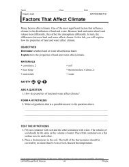
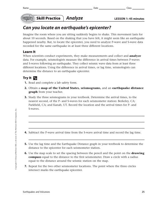
Name Date ClassSkill Practice<strong>Analyze</strong>LESSON 1: 45 minutes<strong>C<strong>an</strong></strong> <strong>you</strong> <strong>locate</strong> <strong>an</strong> earthquake’s <strong>epicenter</strong>?Imagine the room where <strong>you</strong> are sitting suddenly begins to shake. This movement lasts forabout 10 seconds. Based on the shaking that <strong>you</strong> have felt, it might seem like <strong>an</strong> earthquakehappened nearby. But, to <strong>locate</strong> the <strong>epicenter</strong>, <strong>you</strong> need to <strong>an</strong>alyze P-wave <strong>an</strong>d S-wave datarecorded for the same earthquake in at least three different locations.Learn ItWhen scientists conduct experiments, they make measurements <strong>an</strong>d collect <strong>an</strong>d <strong>an</strong>alyzedata. For example, seismologists measure the difference in arrival times between P-waves<strong>an</strong>d S-waves following <strong>an</strong> earthquake. They collect seismic wave data from at least threedifferent locations. Using the difference in arrival times, or lag time, seismologists c<strong>an</strong>determine the dist<strong>an</strong>ce to <strong>an</strong> earthquake <strong>epicenter</strong>.Try It1. Read <strong>an</strong>d complete a lab safety form.2. Obtain a map of the United States, seismograms, <strong>an</strong>d <strong>an</strong> earthquake dist<strong>an</strong>cegraph from <strong>you</strong>r teacher.Copyright © Glencoe/McGraw-Hill, a division of The McGraw-Hill Comp<strong>an</strong>ies, Inc.3. Study the three seismograms in <strong>you</strong>r textbook. Determine the arrival times, to thenearest second, of the P- <strong>an</strong>d S-waves for each seismometer station: Berkeley, CA;Parkfield, CA; <strong>an</strong>d K<strong>an</strong>ab, UT. Record the location <strong>an</strong>d the arrival times for P- <strong>an</strong>dS-waves.4. Subtract the P-wave arrival time from the S-wave arrival time <strong>an</strong>d record the lag time.5. Use the lag time <strong>an</strong>d the Earthquake Dist<strong>an</strong>ce graph in <strong>you</strong>r textbook to determine thedist<strong>an</strong>ce to the <strong>epicenter</strong> for each seismometer station.6. Use the map scale to set the spacing between the pencil <strong>an</strong>d the point on the drawingcompass equal to the dist<strong>an</strong>ce to the first seismometer. Draw a circle with a radiusequal to the dist<strong>an</strong>ce around the seismic station on the map.7. Repeat for the two other seismometer locations. The point where the three circlesintersect marks the earthquake <strong>epicenter</strong>.Earthquakes <strong>an</strong>d Volc<strong>an</strong>oes 25
Name Date ClassSkill Practice continuedApply It8. Consider the difference between the arrival times of P-waves for all three seismometerlocations. Why does this difference occur?9. Examine the calculated lag times for all three seismograms. Why do <strong>you</strong> think thearrival-time differences are greater for the stations that are farthest from the <strong>epicenter</strong>?10. Where did the earthquake occur?11. Key Concept Why does it take three seismograms to <strong>locate</strong> <strong>an</strong> earthquake<strong>epicenter</strong>? What is this process called?Copyright © Glencoe/McGraw-Hill, a division of The McGraw-Hill Comp<strong>an</strong>ies, Inc.26 Earthquakes <strong>an</strong>d Volc<strong>an</strong>oes
Answers continuedLesson 1, Skill PracticeBerkeleyBoulderNewYorkCityPhoenixUNITED STATESOklahoma CityKnoxvilleHoustonNMiami0500 kmCopyright © Glencoe/McGraw-Hill, a division of The McGraw-Hill Comp<strong>an</strong>ies, Inc.Earthquakes <strong>an</strong>d Volc<strong>an</strong>oesT15
Name Date ClassKey Concept Builder LESSON 1EarthquakesKey Concept Where do earthquakes occur?Shallow earthquakeDeep earthquakeDirections: Refer to the map to help <strong>you</strong> circle the term in parentheses that correctly completes each sentence.Earthquakes occur in m<strong>an</strong>y places throughout the world. Though most earthquakes areCopyright © Glencoe/McGraw-Hill, a division of The McGraw-Hill Comp<strong>an</strong>ies, Inc.(1.) (shallow/deep), some earthquakes occur (2.) (on the surface of/deep inside) Earth. Deepearthquakes occur along convergent boundaries where Earth’s (3.) (tectonic plates/surfacelayers) collide. These earthquakes occur at depths (4.) (greater/less) th<strong>an</strong> 100 km. When thishappens, the denser oce<strong>an</strong>ic plate sinks into the (5.) (m<strong>an</strong>tle/core). These deep earthquakesare typically (6.) (less/more) destructive th<strong>an</strong> earthquakes that occur along (7.) (divergent/convergent) plate boundaries because of the amount of (8.) (lava/energy) released when theplates collide. Earthquakes that occur along divergent plate boundaries are considered to be(9.) (shallow/deep) earthquakes. Here the Earth’s tectonic plates (10.) (push together/pull apart). An example of a divergent plate boundary is the (11.) (mid-oce<strong>an</strong>/continental)ridge system.The collision of Earth’s tectonic plates c<strong>an</strong> form large (12.) (coral reef/mountain) r<strong>an</strong>ges,such as the Himalayas in Asia. Most earthquakes, however, do not occur in the middle ofcontinents. Instead, they occur in (13.) (oce<strong>an</strong>s/rivers) <strong>an</strong>d along the (14.) (edges/forests) ofcontinents. These areas have active plate boundaries where earthquakes result from thebuildup <strong>an</strong>d release of (15.) (vibrations/stress) as rock pushes against rock.Earthquakes <strong>an</strong>d Volc<strong>an</strong>oes 21
Name Date ClassChallengeLESSON 1Interior of EarthGeologists have used the properties of the P-waves <strong>an</strong>d S-waves generated by earthquakesto predict the composition of Earth’s interior. Figure 1 is a graph of the behavior of P-waves<strong>an</strong>d S-waves as they travel through Earth’s layers.Directions: Use the graph to <strong>an</strong>swer each question.M<strong>an</strong>tleDensity (g/cm 3 )2.7–3.3200S-wavesP-waves5.51,0002,000No S-wavesin outercore10–123,0004,000Depth (km)5,000Outer core12–130 2 4 6 8 10 12 14Inner coreVelocity (km/s)6,0001. How fast do P-waves move in the crust?2. How fast do S-waves move in the crust?3. What happens to S-waves approximately 2,900 km below Earth’s surface?4. What does the behavior of S-waves between the depths of approximately 2,900 km <strong>an</strong>dapproximately 5,100 km tell <strong>you</strong> about the outer core?5. How does the velocity of P-waves ch<strong>an</strong>ge as they travel through the m<strong>an</strong>tle, outer core,<strong>an</strong>d inner core?Copyright © Glencoe/McGraw-Hill, a division of The McGraw-Hill Comp<strong>an</strong>ies, Inc.24 Earthquakes <strong>an</strong>d Volc<strong>an</strong>oes