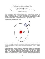
Session K.pdf - Clarkson University
Session K.pdf - Clarkson University
Session K.pdf - Clarkson University

You also want an ePaper? Increase the reach of your titles
YUMPU automatically turns print PDFs into web optimized ePapers that Google loves.
Fig. 1. Suldalslagen from Lake Suldalsvatn to the sea (Sandsfjorden). Kvilldal and Hylen are hydro powerplants and the heavy arrows indicate the flow directionMODELSWe used the two-dimensional lake model QUAL2E(www.epa.gov/docs/QUAL2E_WINDOWS/index.html ) to model the water temperaturesin Lake Suldalsvatn.CalculateWater temperatureand dischargeWeather dataQUAL2EQUAL2ELake Suldalsvatnmain basinTarmenRICESuldalslågenSandsfjordenFig. 2. A sketch of the simulations from Lake Suldalsvatn to the seaThe lake is naturally divided at a shallow and narrow threshold called Suldalsporten.The upper basin is more than 300 m deep while the lower part is less than 40 m deep.To be able to use a rough grid net we divided the simulation into two simulations wherethe Suldalsporten was regarded as a river between two lakes. The river from Suldalsosento the sea (Tjelmane) was analysed by the one-dimensional model RICE (Lal &Shen, 1989). Fig. 2 gives an overview of the simulations.Each of the lake models used two elements in the length direction and had a verticalresolution close to 3 m. The river was modelled as a channel with constant shape and360