GPS PLUS Handheld Terminal - Vectronic Aerospace GmbH
GPS PLUS Handheld Terminal - Vectronic Aerospace GmbH
GPS PLUS Handheld Terminal - Vectronic Aerospace GmbH

Create successful ePaper yourself
Turn your PDF publications into a flip-book with our unique Google optimized e-Paper software.
<strong>GPS</strong> <strong>PLUS</strong> <strong>Handheld</strong> <strong>Terminal</strong><br />
VECTRONIC <strong>Aerospace</strong> <strong>GmbH</strong><br />
Carl-Scheele-Str. 12<br />
D - 12489 Berlin<br />
Germany<br />
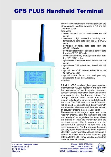
The <strong>GPS</strong> Plus <strong>Handheld</strong> <strong>Terminal</strong> provides the<br />
wireless radio interface between a PC and the<br />
<strong>GPS</strong>-Plus collar.<br />
It is used to<br />
- download <strong>GPS</strong> data sets from the <strong>GPS</strong> <strong>PLUS</strong><br />
collar,<br />
- download high resolution activity and<br />
temperature data sets from the <strong>GPS</strong> <strong>PLUS</strong><br />
collar,<br />
- download mortality data sets from the<br />
<strong>GPS</strong> <strong>PLUS</strong> collar,<br />
- download proximity or additional sensor data<br />
from the <strong>GPS</strong> <strong>PLUS</strong> collar,<br />
- download telemetry (status) information from<br />
the <strong>GPS</strong> <strong>PLUS</strong> collar,<br />
- upload UTC time and date to the <strong>GPS</strong> <strong>PLUS</strong><br />
collar,<br />
- upload new <strong>GPS</strong> schedule to the <strong>GPS</strong> <strong>PLUS</strong><br />
collar,<br />
- upload new VHF beacon schedule to the<br />
<strong>GPS</strong> <strong>PLUS</strong> collar,<br />
- upload virtual fence data and proximity<br />
schedule to the <strong>GPS</strong> <strong>PLUS</strong> collar,<br />
in the field.<br />
A built in <strong>GPS</strong> receiver gives you important<br />
information about your position in the field. With<br />
the assistance of an integrated electronic<br />
compass and the internal <strong>GPS</strong> receiver it is now<br />
very easy to find the tracked animal. The<br />
“Range Checker Mode” opens unbeatable<br />
support in finding the direction and distance to<br />
the collar. The <strong>GPS</strong> and compass information<br />
will be used to calculate and display azimuth<br />
and elevation (direction) and the distance with<br />
an accuracy of some meters to your collar.<br />
The communication range is dependent on the<br />
receiver antenna gain, the humidity, the kind<br />
and density of the vegetation, the height above<br />
the ground of both the transmitter and the<br />
receiving system, the topography and the<br />
configuration between transmitting and<br />
receiving antenna. For that reasons the range<br />
can vary from several hundred meter to several<br />
kilometer. Under normal conditions, the range is<br />
several kilometer with a small handheld yagi<br />
antenna for the UHF version and some hundred<br />
meter for the VHF version.<br />
Phone: +49 30 6789 4990<br />
Fax: +49 30 6789 5230<br />
Internet: www.vectronic-aerospace.com<br />
E-Mail: mail@vectronic-aerospace.com
Specifications<br />
Size 204 x 110 x 41 mm³ without antenna connector<br />
Weight 550 g<br />
Keyboard 21 keys membrane keypad<br />
Display 128 x 64 Pixel Matrix display with LED background illumination<br />
Memory capacity 512 MByte (data storage for up to 512 collars),<br />
Up to 8 GByte with extended memory<br />
315520 Temperature and activity data sets per collar<br />
131072 <strong>GPS</strong> data sets<br />
2 Mbyte additional sensor memory per collar, e.g. for proximity data<br />
Battery Internal rechargeable Li-Ion battery 3.6 Volt / 6000 Ah<br />
Charging time less than 8 hours typ.<br />
Operating time with Dependent on operation mode<br />
charged battery (70 hours <strong>GPS</strong> mode, 75 hour receive mode)<br />
External power supply Only needed for charging the battery 12 Volt, 800 mA max.<br />
Interface Serial Interface 115200 baud 8N1 (to be connected to LM1 Link<br />
Manager), USB up to 8 MBit/s<br />
Ingress protection IP65<br />
<strong>GPS</strong> Receiver Internal <strong>GPS</strong> receiver<br />
UHF frequency 420 - 460 MHz or 800 - 950 MHz (factory setting), UHF Version only<br />
VHF frequency 130 - 300 MHz (factory setting), VHF Version only<br />
Output power UHF Version: 0.1 - 1 W (factory setting)<br />
VHF Version: 1 - 10 mW (factory setting)<br />
Modulation DFM<br />
Antenna impedance 50 Ohm<br />
Compass module Built in electronic compass with tilt compensation,<br />
resolution 1 mgauss, range 1 gauss<br />
Operating temperature: 0°C...+50°C (charging), -20°C...+60°C (non charging)<br />
Storage temperature: -40°C...+80°C<br />
Wireless bi-directional data<br />
<strong>Handheld</strong> <strong>GPS</strong> <strong>PLUS</strong> Collar<br />
VECTRONIC reserves the right to change the specifications without notice at any time