JeppView : LOWI (13 charts)
JeppView : LOWI (13 charts)
JeppView : LOWI (13 charts)

You also want an ePaper? Increase the reach of your titles
YUMPU automatically turns print PDFs into web optimized ePapers that Google loves.
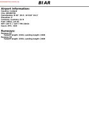
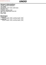
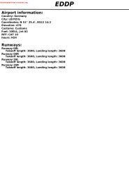
Downloaded from rutracker.org<strong>LOWI</strong>Airport information:Country: AustriaCity: INNSBRUCK INTLCoordinates: N 47° 15.6', E011 20.6Elevation: 1907Customs: CustomsFuel: 100LL, Jet A1RFF: CAT 8hours: AD administration: 0530-1900, TWR: 0500-2200Runways:Runway 08Takeoff length: 2000, Landing length: 1897Runway 26Takeoff length: 1940, Landing length: 1940
If you like to use this <strong>charts</strong>, please, buy a subscription for nDAC.For rutracker.orgGENERAL10 - 5 04 APR <strong>13</strong>Austria - <strong>LOWI</strong> / INNINNSBRUCKlowi05gaorg0© Navtech -This plain language appendix refersespecially to existing haze layer and asfar as possible to the estimated visibilityabove these haze layers.4.2.10 GLIDER ACTIVITYExtensive glider operation (both byaero-tow and winch-launching) maytake place at Innsbruck AD down to aground visibility of 5km and a ceiling of450m (1500ft).When winch-launchings are executedthere are obstacles (winch and glidersnot closer than 100m to the RWYcentreline) in the north-western part ofthe safety strip of RWY 08/26.Pilots of IFR flights will be informed byATC about any activity.Extreme caution during specialthermic conditions: Expect extensiveglider flying activity and a large numberof glider movements in the vicinity ofKellerjoch (APRX D18 OEV).More information will be provided onATIS Innsbruck in this case.4.2.11 Meteorological minima (day and night)- For approaching IFR flights:Flight visibility : refer to <strong>charts</strong> oraccording special authorization.- For departing IFR flights:Ground visibility 1500mCeiling 1500ftSpecial performance departure:RVR 300mTake-off alternate required!- Pilots are reminded that abovementioned or in the specialauthorization permitted values areabsolute MINIMA and shall be usedonly by pilots with extended flightexperience into Innsbruck AD.5. APP / DEP AUTHORIZATION / ATCPROCEDURES5.1 Except to pilots, holding a specialauthorization, NO approach clearancewill be issued by ATC below thefollowing minima (exceptions see 5.2below): Ground visibility 1500m;Ceiling <strong>13</strong>00ft AAL or5.2 In case of fog, haze, mist layers orblowing snow in the vicinity of the AD(see 4.2.9) an approach clearance willbe granted on pilots request provided:• the RVR is at least 1000m• the visibility above these layers is atleast 5km and• there are no further clouds below3100ft AAL.5.3 Except for special performancedeparture procedure, NO clearance willbe issued by ATC below the followingminima (exceptions see 5.4 below):Departures RWY 08 and 26Ground visibility 1500m and/orCeiling <strong>13</strong>00ft AAL5.4 In case of low layers of fog, haze, mist(low stratus) or blowing snow (see 4.2.9)a clearance for departure on RWY 08will be granted on request to pilots formulti engine ACFT only provided:• the RVR is at least 600m• the visibility above these layers is atleast 5km and• there are no further clouds below3100ft AAL• one engine out climb gradient MNM4.8%• pilots qualified according section 4.6. NIGHT FLIGHTSFor flights during night it has to beadditionally noted:6.1 In case two or more neighbouring lightsor hazard beacons south of the ADare inoperative, approaching ACFT willbe informed immediately by ATC. Thedecision to make the approach or tocontinue the approach comes from thePIC.6.2 For circling approach to RWY 08 andtake-off on RWY 26 one of the two mostwest blinking lights has to be inoperation.10 - 5Reverse side blankTHIS Change: CHART New IS print A PART OF NAVIGRAPH CHARTS AND IS INTENDED FOR FLIGHT SIMULATION USE ONLY
If you like to use this <strong>charts</strong>, please, buy a subscription for nDAC.For rutracker.orgGENERALWEF <strong>13</strong> DEC 12Instrument Procedures10 - 7 01 NOV 12Austria - <strong>LOWI</strong> / INNINNSBRUCKlowi07gaorg0© Navtech -1. AUTHORIZATION1.1 The use of any special procedureor any deviation from the publishedprocedures, requires authorizationfrom Austro Control GmbH/ACG. Onlyoperators whose pilots are familiarwith the mountainous terrain and theother circumstances in the vicinityof Innsbruck AD may apply for suchauthorization. This authorization doesnot relieve the operator/pilot to obtainan approval/acceptance from thecompetent CAA of the state of theoperator/pilot if so required.1.2 The application to ACG shall contain:• ACFT and engine type• MAX permissible landing/take off mass• information on ACFT performance (e.g.one engine out climb performance)• requested meteorological minima• IAC intended for use.The following performance data (asapplicable) are required for an altitudeof 3500ft AMSL:1. all engines IAS and bank angleapplied,- at ISA +10°C,- at ISA -10°C andanti-ice equipment on as required2. one engine out climb gradient,IAS and bank angle applied,- at ISA +10°C,- at ISA -10°C andanti-ice equipment on as requiredNote: Sample calculations and detailsfor approval shall be obtained byspecial.procedures@austrocontrol.atThe relevant performance data shall besubmitted in a listed form includingcopies of the relevant pages of theAeroplane Flight Manual or otherapproved Performance data.1.3 Applications shall be conveyed atleast six weeks prior to the intendedoperations.Operators shall address theirapplication to:Austro Control GmbHFlugsicherungsstelle InnsbruckATM/TERM InnsbruckPostfach 16026 InnsbruckAustriaFax: +43 (0)5 1703 6656+43 (0)5 1703 6666email:special.procedures@austrocontrol.at(Ernst.Wieser@austrocontrol.at)2. INSTRUMENT APPROACHPROCEDURE WESTLOC/DME West via NDB KTI.2.1 General provisionsA bi-directional localizer (OEJ 109.7,Frontbeam 067°, Backbeam 065°)located 10nm ENE of the AD, and offsetfrom the RWY centreline, is providedfor the instrument flight segment of thedescent procedure and also for trackguidance during climb phase in the caseof failure to establish effective externalvisual reference at decision point. Aco-located DME provides distanceinformation for regulating the descentand discontinued descent flight profiles.The visual flight segment includes aturn of more than 180° after passing thedecision point some 6nm ENE of the ADin order to position the ACFT for finalapproach RWY 26 or for circling RWY 08.2.2 Initial approach segmentMain radio navigational aid and initialapproach fix for this procedure is NDBKTI.Enter the holding pattern of NDB KTIand descend - if necessary - to <strong>13</strong>000ftAMSL. Positively identify LOC OEJ notlater than overhead NDB KTI.ACFT approaching via VOR/DME KPTon R<strong>13</strong>8 shall maintain <strong>13</strong>000ft inboundto NDB KTI. For direct approach ACFTmay descent to 11500ft AMSL afterpassing D39 KPT.Turn overhead NDB KTI to QDR 104° at11500ft or above and continue approachaccording to item below.Remark: Do NOT enter the holdingpattern NDB KTI below <strong>13</strong>000ft AMSL.10 - 7THIS Change: CHART 1, 2IS A PART OF NAVIGRAPH CHARTS AND IS INTENDED FOR FLIGHT SIMULATION USE ONLY
If you like to use this <strong>charts</strong>, please, buy a subscription for nDAC.For rutracker.orgGENERAL10 - 8 15 OCT <strong>13</strong>Instrument ProceduresAustria - <strong>LOWI</strong> / INNINNSBRUCK10 - 8lowi08gaorg0© Navtech -2.3 Intermediate approach segmentACFT in the holding pattern NDB KTI(according to item 2.2 a) shall leave<strong>13</strong>000ft AMSL on 104° inbound to NDBKTI, pass NDB KTI on 104° at 11500ftor above. Maintain 11500ft AMSL untilpassing D20.4 OEJ.After passing D20.4 OEJ descendto 10500ft AMSL and establish onLOC. Maintain 10500ft or above untilestablished on lOC.2.4 Final approach to MDADescend on LOC (067°) to MDA,checking altitude at:D17.4 OEJ MNM 10500ftD14.4 OEJ MNM 9000ftD11.4 OEJ MNM 7500ftD6.5 OEJ MNM 5000ftA descent gradient of 8.2% (i.e. 4.7°)respectively 500ft/nm is required.MDA should be reached at D6.3 OEJIf no effective external visual reference atD6.5 OEJ continue on LOC course 067°.2.5 Missed approach procedureFinal decision point to commence theVISUAL SEGMENT of the instrumentapproach procedure is D4.4 OEJ / L AB(MAPt).Note: SOC is assumed at D4.1 OEJAt OEJ change to 065° using LOC andcontinue with MAX climb gradient. Whencrossing 9500ft AMSL turn left to NDBRTT and hold.Due to erroneous LOC indications whenoff centreline from D2 before until D2after LOC station, use locator AB foradditional guidance.MNM required missed approach climbgradient:2.5% up to 7000ft AMSL2% above 7000ft AMSL2.6 Visual manoeuvreMeteorological minima within the area ofvisual manoeuvre see GENERAL 4.2.11.Having established effective externalvisual reference at decision point, makea right turn in level flight.MAX turn radius 1700m.When reaching westerly heading, ensurethat the approach to the AD can beaccomplished visually.If found impossible to maintain VISUALconditions on approach to the AD, rightturn to rejoin LOC OEJ via locator ABand follow missed approach procedureas described in 2.5.If meteorological conditions guaranteea safe approach and landing, continueVISUALLY either straight-in to final forRWY 26, or on a right hand traffic circuitto RWY 08.Recommended practice during FOEHNconditions see GENERAL 4.2.6.3. INSTRUMENT APPROACHPROCEDURE EASTLOC/DME EAST via NDB RTT.LOC OEJ for missed approach NOTapproved!3.1 General provisionsA localizer (OEV 111.1, LOC course255°) on the AD but 4° offset fromthe RWY centerline and a collocatedDME are providing course guidanceand distance information during theinstrument phase of the descentprocedure and in case of a missedapproach. A glidepath which isfrequency paired with LOC OEV isavailable coinciding with the DMEdescent gradient of 3.8° between D19OEV and the threshold.The visual part of the procedurerequires effective external VISUALreference at the applicable MAPt.3.2 Initial approach segmentMain radio navigational aid and initialapproach fix for this procedure is NDBRTT.If necessary enter the holding patternof NDB RTT, (inbound 226°, right turn,9500ft AMSL).LOC and DME OEV on 111.1 shallbe positively identified not later thanoverhead NDB RTT (D26.1 OEV).3.3 Intermediate approach segmentLeave NDB RTT on QDR 210°, continuedescent - if necessary - to 9500ft AMSLand intercept LOC about D21 OEV(LOC course 255°); maintain 9500ft orabove until passing D19 OEV.THIS Change: CHART 3.1, IS 3.3 A PART OF NAVIGRAPH CHARTS AND IS INTENDED FOR FLIGHT SIMULATION USE ONLY
If you like to use this <strong>charts</strong>, please, buy a subscription for nDAC.For rutracker.orgGENERAL10 - 9 15 OCT <strong>13</strong>Instrument ProceduresAustria - <strong>LOWI</strong> / INNINNSBRUCKlowi09gaorg0© Navtech -3.4 Final approach to MDACommence final descent on LOCcourse 255° when passing D19 OEV(FAF) and descend to MDA, checkingaltitude at DME FIX:D19 OEV MNM 9500ftD17 OEV MNM 8700ftD14 OEV MNM 7500ftD9 OEV MNM 5500ftD6.3 OEV MNM 4400ftD3.5 OEV MNM 3300ftThe GP information coincides with theabove prescribed altitudes between D19and the MDA.A descent gradient of 6.59% (i.e. 3.77°)respectively 400ft/nm is required.If no effective external visual referenceat the MAPt, or when discontinuing anapproach between D19 OEV and MAPt,climb on LOC course 255° to D1 OEV.Note: The LOC course is 4° offset fromthe RWY centreline!3.5 Missed approach segment anddiscontinued approach procedureFinal decision point to commence theVISUAL SEGMENT of the instrumentapproach procedure is the MAPt.At D1 OEV turn left on to QDM 060° tolocator AB. MAX turn radius 1700m.Rejoin LOC OEV (111.1) outbound andcontinue with MAX climb gradient. Whencrossing D14 OEV, left to NDB RTT andenter the hold at 9500ft.MNM required missed approach climbgradient:MDA 4900ft 2.5% MAPt D7.5 OEVMDA 4400ft 3% MAPt D6.3 OEVMDA 3700ft 4% MAPt D4.5 OEVMDA 3300ft 5% MAPt D3.5 OEV3.6 Visual segmentMeteorological minima see GENERAL4.2.11.Having established effective externalVISUAL reference between locator ABand MAPt the flight shall be continuedwith visual reference either straightinto RWY 26 (distance dependingon MAPt versus missed approachclimb performance) or on to a righthand traffic circuit to RWY 08. Theprescribed minimum flight visibility shallbe observed during the visual part of theprocedure.Recommended practice during FOEHNconditions see GENERAL 4.2.6.4. SPECIAL INSTRUMENT APPROACHPROCEDURE EASTLOC/DME EAST via NDB RTT.Missed approach along LOC OEJ!4.1 General provisionsThe use of this procedure is onlyfor multi engine ACFT with specialperformance, e.g. specific turn radii,increased one-engine out missedapproach climb gradient and requires apermission by the competent authorityas described in item 1 above.Special crew training is required.Any deviation requires specialdocumentation by the operator/PIC!!A localizer (OEV 111.1, LOC course255°) on the AD but 4° offset fromthe RWY centerline and a collocatedDME are providing course guidanceand distance information (DME - FIX)during the instrument phase of thedescent procedure and in case of amissed approach. A glide-path whichis frequency paired with LOC OEVis available coinciding with the DMEdescent gradient of 3.8° between D19OEV and the threshold.4.2 Initial approach segmentMain radio navigational aid and initialapproach fix (IAF) for this procedure isNDB RTT.If necessary enter the holding patternof NDB RTT, (inbound 226°, right turn,9500ft AMSL).LOC and DME OEV on 111.1 shallbe positively identified not later thanoverhead NDB RTT (D26.1 OEV).4.3 Intermediate approach segmentLeave NDB RTT on QDR 210°, continuedescent - if necessary - to 9500ft AMSLand intercept LOC about D21 OEV (LOCcourse 255°), maintain 9500ft or aboveuntil passing D19 OEV.10 - 9THIS Change: CHART 3.4, IS 3.5, A PART 4.1, 4.3 OF NAVIGRAPH CHARTS AND IS INTENDED FOR FLIGHT SIMULATION USE ONLY
If you like to use this <strong>charts</strong>, please, buy a subscription for nDAC.For rutracker.orgGENERAL10 - 10 15 OCT <strong>13</strong>Instrument ProceduresAustria - <strong>LOWI</strong> / INNINNSBRUCK10 - 10lowi10gaorg0© Navtech -4.4 Final approach to MDACommence final descent on LOC course255° when passing D19 OEV (FAF) anddescend to approved MDA, checkingaltitude at DME FIX:D19 OEV MNM 9500ftD17 OEV MNM 8700ftD14 OEV MNM 7500ftD9 OEV MNM 5500ftD6.3 OEV MNM 4400ftD5 OEV MNM 3900ftD3.5 OEV MNM 3300ftThe GP information coincides with theabove prescribed altitudes between D19and the MDA.A descent gradient of 6.59% (i.e. 3.77°)respectively 400ft/nm is required.If no effective external visual referenceat the MAPt, or when discontinuing anapproach between D19 OEV and MAPt,climb on LOC course 255° to D0.8 OEV.Note: The LOC course is 4° offset fromthe RWY centreline!4.5 Missed approach segmentFinal decision point to commencethe visual segment of the instrumentapproach procedure is the approvedMAPt.At D0.8 OEV climb in a left turn andfollow QDM 060° to locator AB.MAX turn radius 1600m.Latest over locator AB join LOC/DMEOEJ (109.7) and continue climb onLOC OEJ (067°/065°) with MAX climbgradient.When crossing 9500ft AMSL turn left toNDB RTT and hold.Due to erroneous LOC indications whenoff centreline from D2 before until D2after LOC station, use locator AB foradditional guidance.MNM required missed approach climbgradient:According special authorization.Note: Sample calculations and detailsfor approval shall be obtained by special.procedures@austrocontrol.at.4.6 Visual segmentMeteorological minima:According special authorization.Having established effective externalVISUAL reference (between locator ABand MAPt) the flight shall be continuedwith visual reference either straight-into RWY 26 or on to a right hand trafficcircuit to RWY 08.Recommended practice during FOEHNcondition see GENERAL 4.2.65. RNAV (RNP) RWY 26 - PROCEDUREGUIDELINES (AUTHORIZATIONREQUIRED)for the application to the Austrian CAA(refers to the procedure on chart!)5.1 Purpose and ScopeThis RNAV (RNP) AR Procedureis based on ICAO Doc 9905. Theprocedure offers possible benefits oflast generation airborne navigationcapabilities for the design of instrumentflight procedures in terrain criticalenvironment. ARINC 424 RF codingand navigation capability reduces thesize of protected airspace during turnsignificantly since no wind spiral has tobe considered.Note: To assure availability of GNSSsignal operators/pilots shall performa RAIM check. A tool (AUGUR byEUROCONTROL) is avbl on: http://augur.ecacnav.com/5.2 Procedure Characteristics:Nominal descent angle from FAF toMAPt is 3.5°.Protected airspace is based on 2x RNP(e.g. 0.6nm for RNP 0.3).Protected airspace during RF Leg inaccordance with ICAO Doc 9905.The use of ARINC Path Terminators forthe coding of the procedure must belimited to the following leg types: IF, TF,RF, HM.ARINC 424 coding of the procedure forthe transition from WI007 to WI008 mustbe RF.During RF transition IAS must notexceed 165kt.The required MNM missed approachclimb gradient is 2.5% (ICAO PANS-OPS Standard).THIS Change: CHART 4.4IS A PART OF NAVIGRAPH CHARTS AND IS INTENDED FOR FLIGHT SIMULATION USE ONLY
If you like to use this <strong>charts</strong>, please, buy a subscription for nDAC.For rutracker.orgGENERALWEF 14 NOV <strong>13</strong>Instrument Procedures10 - 11 15 OCT <strong>13</strong>Austria - <strong>LOWI</strong> / INNINNSBRUCKlowi11gaorg0© Navtech -This procedure requires specialauthorization by Austro Control. Thisauthorization does not relieve theoperator/pilot to obtain an approval/acceptance from the competent CAAof the state of the operator/pilot if sorequired.5.3 Equipment RequirementsApproved Dual FMS installationaccording AC20-<strong>13</strong>8B including RNPcapability of 0.3nm or better.Dual GNSS and at least one IRS orequivalent DME/DME or VOR/DME orLOC update not authorized.FMS must be capable to performARINC 424 RF Path Terminator.Required RNAV RNP functionsaccording EASA AMC 20-26.5.4 ApplicationOnly operators/pilots of multi-engineACFT shall apply for such permission.The application shall contain:• ACFT type• FMS type and certification• instrument approach and landing chart• flight crew training documentationfor normal and non normal operationincluding documentation changes(FCOM, AFM, etc.)• Data file with ARINC 424 coding of theprocedure• Safety Analysis in regard to accuracy,integrity, continuity and availability fornormal and non normal operations.The relevant data shall be submitted ina listed form together with copies of therelevant pages of the Aeroplane FlightManual or Performance Manual and - ifrelevant other certified data.Application shall be conveyed at leastsix weeks prior to the operations.Note: Details for approval shall beobtained by special.procedures@austrocontrol.at.Application as under item 1.3.6 LOC ROMEO APPROACH –PROCEDURE GUIDELINES(AUTHORIZATION REQUIRED)(LOC/DME EAST PROCEDUREFOLLOWED BY RNAV RNP 0.3MISSED APPROACH)for the application to the Austrian CAA(refers to the procedure on chart!)6.1 Purpose and ScopeThis LOC/DME approach procedurefollowed by an RNAV RNP 0.3 missedapproach is based on ICAO Doc 8168and 9905 and merges the benefits ofLOC-accuracy on final and initial missedapproach as well as RNAV RNP 0.3accuracy during the further missedapproach. ARINC 424 RF coding andnavigation capability in the missedapproach reduces the size of protectedairspace during turn significantly sinceno wind spiral has to be considered.Note: To assure availability of GNSSsignal operators/pilots shall performa RAIM check. A tool (AUGUR byEUROCONTROL) is available on:http://augur.ecacnav.com/6.2 Procedure Characteristics:The approach is a LOC/DME approach(equal to LOC/DME East approachaccording item 3) with initial missedapproach along MT 255° to WI700(= LOC Station OEV).Nominal descent angle from FAF toMAPT is 3.8°.Protected airspace in the final approachis based on OAS according ICAO Doc8168 Vol. II.Protected airspace during missedapproach is based on 2x RNP (e.g.0.6nm for RNP 0.3) in accordance withICAO Doc 9905.If no effective external visual referenceat the MAPt or when discontinuing anapproach between D19 OEV and theMAPt, climb with maximum gradient onMT 255° to WI700 (LOC course OEV255° provides guidance until shortbefore WI700), thereafter the missedapproach is based on RNAV RNP 0.3and therefore LNAV shall be engagedaccordingly.10 - 11THIS Change: CHART 6 IS A PART OF NAVIGRAPH CHARTS AND IS INTENDED FOR FLIGHT SIMULATION USE ONLY
If you like to use this <strong>charts</strong>, please, buy a subscription for nDAC.For rutracker.orgWEF 14 NOV <strong>13</strong>GENERALInstrument Procedures10 - 12 15 OCT <strong>13</strong>Austria - <strong>LOWI</strong> / INNINNSBRUCK10 - 12lowi12gaorg0© Navtech -Climb and follow the further missedapproach procedure as charted for thisapproach (basically the same as for theRNAV (RNP) approach RWY 26 (item5).During RF transition IAS must notexceed 165kt.This procedure requires specialauthorization by Austro Control. Thisauthorization does not relieve theoperator/pilot to obtain an approval/acceptance from the competent CAAof the state of the operator/pilot if sorequired.6.3 Equipment RequirementsApproved Dual FMS installationaccording AC20-<strong>13</strong>8C including RNPcapability of 0.3nm or better (≤ 0.3nm).Dual GNSS and at least one IRS orequivalent DME/DME or VOR/DME notauthorized for update during missedapproach.FMS must be capable to perform ARINC424 RF Path Terminator.Required RNAV RNP functionsaccording EASA AMC 20-26.6.4 ApplicationOnly operators/pilots of multi-engineACFT shall apply for such permission.The application shall contain:• ACFT type• Relevant details of the AFM showingcompliance with the requirements• Standard Operating Procedures andflight crew training documentationfor normal and non normal operationincluding documentation changes(FCOM, AFM etc.)• Safety Analysis in regard to accuracy,integrity, continuity and availability fornormal and non normal operations• A shortened approval process willbe applied for operators holding anapproval for RNAV RNP 26 accordingitem 5The relevant data shall be submitted ina listed form together with copies of therelevant pages of the Aeroplane FlightManual and - if relevant other certifieddata.Applications shall be conveyed atleast six weeks prior to the intendedoperations.Note: Details for approval shall beobtained by special.procedures@austrocontrol.atApplication as under item 1.3.THIS Change: CHART 6 IS A PART OF NAVIGRAPH CHARTS AND IS INTENDED FOR FLIGHT SIMULATION USE ONLY
If you like to use this <strong>charts</strong>, please, buy a subscription for nDAC.For rutracker.orgGENERALWEF 14 NOV <strong>13</strong>10 - <strong>13</strong> 15 OCT <strong>13</strong>Instrument Procedures7. DEPARTURE PROCEDURES7.1 Due to mountainous terrain close to theAD and as well as along the departureflight path it is absolutely necessary toobserve the required MNM climbgradient as prescribed below.7.2 When departing on RWY 08 andFOEHN influence is encountered,execute initial climb north of RWYcentreline to avoid turbulence over thecity of Innsbruck.7.3 For departure procedures OEJLOC/DME 109.7 shall be used.Austria - <strong>LOWI</strong> / INNINNSBRUCKREQUIRED MINIMUM CLIMB PROFILE WHEN DEPARTING INNSBRUCKDME OEJ zero indication electronically extended (2 x 670m).D7.5OEJABD4.4OEJLOC/DMEOEJD7OEJRTTD15.4 OEJMin holding at 9500InterceptLOC OEJElev 081907Elev 261894Visual03.3%480067005900650044304 6 10 15 20 25 30 35nm11.34nm(21km)3.3%067°17nm(31.5km)3.3%065°23.76nm(44km)Obstacle identificationSurface© Navtech -lowi<strong>13</strong>gaorg0Reverse side blank10 - <strong>13</strong>THIS Change: CHART RenumberedIS A PART OF NAVIGRAPH CHARTS AND IS INTENDED FOR FLIGHT SIMULATION USE ONLY
If you like to use this <strong>charts</strong>, please, buy a subscription for nDAC.For rutracker.orgChange: MOGTI 1X, ALT, TATHIS CHART IS A PART OF NAVIGRAPH CHARTS AND IS INTENDED FOR FLIGHT SIMULATION USE ONLYInnsbruck TWR RAD ATIS120.1 119.275 126.025WI802Navtech - lowi01daorg0TA 11000 AD Elev 1907WI0076750N47 19.2E010 59.0MOGTI 1XMOGT1X211 RF LEGMAX 165ktTurn radius1.35nmNOTE:50002MOGTI5700070009100WI502 87007100 WI0069900280°4.34.3065°5000WI008N47 16.6E010 59.49500990093007000900030005000GermanyAustria88003000WI802WI5025010291° 8.1 111°259° 2.792002973WI005WI5018700 300031906430 3087N47 15.1E011 16.1 N47 15.18500E011 16.192007.4079°50005000WI103N47 16.3E011 26.875987000700050003000303516.7 066°47470 5 10 15nmThis SID is permissable for special performance ACFT only and requires authorization byAustro Control GmbH to execute RNP 0.3 Approach Proc.MOGTI 1X 8% until passing 71005.6% until passing <strong>13</strong>000WI501 - WI502 - WI802 - MOGTIWI501 MNM 3190WI502 MNM 7100WI802 MNM 10520MOGTI MNM <strong>13</strong>000RATTENBERG 2X 7% until WI005, thereafter WI005 - WI006 - WI007 - WI008 - WI006 - WI005 MNM 30005% until passing WI008 WI005 - WI103 - WI002 - WI001.WI006 MNM 5450WI007 MNM 6750WI001 MNM 11500N47 23.3E010 43.0265°700010.<strong>13</strong>16°MOGT1XN47 18.3E011 05.2850070007.55000300050008200N47 18.3E011 05.28900N47 17.8E010 50.469008400 9000SID MNM Climb Routeing Altitude<strong>13</strong>000MOGTI 1X8600545010520SPECIAL AUTHORIZATION REQUIREDGNSS and IRS requiredDME/DME, LOC and VOR/DME updating not authorized820087003000700088008700890090009200840068006900RTT2X890050007000119 1<strong>13</strong>ARP4145 <strong>13</strong>790005000RATTENBERG 2X1009100015418030007700500070008200085270Rattenberg303 RTTN47 25.9E011 56.4WI001N47 25.9E011 56.44<strong>13</strong>430005.7053°WI002N47 22.6E011 49.530001073 4118<strong>13</strong>63 MOGTIN47 23.3E010 43.012011500210116WI0014142045295103Austrian territory only59005000270SID RWY 26RNAV(RNP 0.3) INNSBRUCK30 - 108 MAR <strong>13</strong>WEF 04 APR <strong>13</strong>Austria - <strong>LOWI</strong> / INNReverse side blank
If you like to use this <strong>charts</strong>, please, buy a subscription for nDAC.For rutracker.orgChange: Marker R withdrawnTHIS CHART IS A PART OF NAVIGRAPH CHARTS AND IS INTENDED FOR FLIGHT SIMULATION USE ONLYADILONavtech - lowi03daorg0Innsbruck TWR RAD ATIS120.1 119.275 126.025TA 11000 AD Elev 19073087297392008400289°GermanyAustria8200700020Innsbruck420 INNN47 <strong>13</strong>.8E011 24.1081°D4.4 OEJAbsam3<strong>13</strong> ABN47 17.3E011 30.1D6.5OEJ3000067°KOGOL2 Due to erroneous LOC indicationswhen off CL from D2 before untilD2 after LOC OEJ, use QDR locatorAB as additional guidance.9000500030008800759870002LOC/DME1ADIL1J5000109.7 OEJN47 18.9E011 36.14800D0 OEJ4 067°ADILO 1J92007500ADILO 1J9000KOGOL 2JKOGO2J128 065°D15.4 OEJ1 If unable to cross D0 OEJ at 4800ftand D7 OEJ at 6700ft, a higher ceilingand visibility is necessary. In this caseclimb visually either via AB MNM 4700ftor marker "R" MNM 4300ft.Contingency procedures are underthe responsibility of the operator.5000Rattenberg303 RTTN47 25.9E011 56.43 Austrian territory onlyKOGOL 2JOBEDI 2JContinue along LOC OEJ 067°/065° to 9500Continue along LOC OEJ 067°/065° to 9500- turn left to RTT - KOGOL.- turn left to RTT - OBEDI.1 D0 OEJ MNM1 D7 OEJ MNM48006700RASTA 3JContinue along LOC OEJ 067°/065° to 9500 - turn left to RTT - RASTA.RATTENBERG 2JContinue along LOC OEJ 067°/065° to 9500 - turn left to RTT.UNKEN 1JContinue along LOC OEJ 067°/065° to 9500 - turn left to RTT - UNKEN.296°25500030003000RTT2J046°5000226°0 5 10nmNOTEFor DEP proc LOC/DME 109.7 OEJ shall be used. For futher guidence see GENERAL Instrument Procedures.COMContact RAD when advised by TWR.WX MIN DAY AND NIGHTVIS 1500m, Ceiling 1500ftDuring VISUAL OPS: CAT C/D VIS 5kmCAT A/B VIS 3km890069006700D7 OEJUNKE1J35 047°57 094°59 084°SID MNM Climb Routeing AltitudeClimb on 081° with MAX gradient until intercepting LOC OEJ (about D7.5 OEJ)INITIAL CLIMBinbound to AB - follow SID.ADILO 1J8.8% until D0 OEJ,thereafter 6.5% untilContinue along LOC OEJ 067° - at D0 OEJ turn right (MAX 165kt, MNM bank 25°)to INN - ADILO.D0 OEJ MNM 7500completion of turn. ALTN routing: RTT 2J - INN - ADILO.4.8% to 6700.110007700MAX 165ktMNM bank 25°RATTENBERG 2J95008000300095007600UNKEN 1J95007400<strong>13</strong>000120008000UNKENRAST3JRASTA 3JOBEDI 2J120OBED2J103RTT116 31420452703000RASTAOBEDISID RWY 08KOGO2J, OBED2J, RAST3J, RTT2J, UNKE1J30 - 314 JUN <strong>13</strong>INNSBRUCKAustria - <strong>LOWI</strong> / INN
If you like to use this <strong>charts</strong>, please, buy a subscription for nDAC.For rutracker.orgAustria - <strong>LOWI</strong> / INNINNSBRUCK30 - 4 14 JUN <strong>13</strong>KOGO2H, OBED2H, RAST3H, RTT2H, UNKE1HSID RWY 26Austria - <strong>LOWI</strong> / INNINNSBRUCKInnsbruck TWR RAD ATIS120.1 119.275 126.025TA 11000 AD Elev 1907ADILOZirl30872973067°920087008400Germany8200Austria7000289°Innsbruck420 INNN47 <strong>13</strong>.8E011 24.120D4.4 OEJAbsam3<strong>13</strong> ABN47 17.3E011 30.1D6.5OEJ3000KOGOL1 Due to erroneous LOC indicationswhen off CL from D2 before untilD2 after LOC OEJ, use QDR locatorAB as additional guidance.900030005000880075987000LOC/DME1ADIL1H5000109.7 OEJN47 18.9E011 36.14800D0 OEJ4 067°47479200ADILO 1H7700ADILO 1HKOGO2H28 065°296°25D15.4 OEJRattenberg303 RTTN47 25.9E011 56.4NOTEFor DEP proc LOC/DME 109.7 OEJ shall be used. For futher guidence see GENERAL Instrument Procedures.COMContact RAD when advised by TWR.WX MIN DAY AND NIGHTVIS 1500m, Ceiling 1500ftDuring VISUAL OPS: CAT C/D VIS 5kmCAT A/B VIS 3km9000KOGOL 2H690089006700D7 OEJ500030003000046°5000226°35 047°57 094°259 084°ADILO 1H6.5% until D0 OEJ,thereafter 6% untilContinue along LOC OEJ 067° - at D0 OEJ turn right (MAX 165kt, MNM bank 25°)to INN - ADILO.D0 OEJ MNM 7700completion of turn. ALTN routing: RTT 2H - INN - ADILO.KOGOL 2HOBEDI 2HContinue along LOC OEJ 067°/065° to 9500Continue along LOC OEJ 067°/065° to 9500- turn left to RTT - KOGOL.- turn left to RTT - OBEDI.D0 OEJ MNMD7 OEJ MNM48006700RASTA 3HContinue along LOC OEJ 067°/065° to 9500 - turn left to RTT - RASTA.RATTENBERG 2HContinue along LOC OEJ 067°/065° to 9500 - turn left to RTT.UNKEN 1HContinue along LOC OEJ 067°/065° to 9500 - turn left to RTT - UNKEN.RTT2H59000 5 10nmSID MNM Climb Routeing AltitudeClimb visually with MAX gradient until along the northern side of the valleyINITIAL CLIMB(visual track 270°-275°) - in the area of the village Zirl turn visually left -join LOC OEJ 067° inbound to AB - follow SID.11000MAX 165ktMNM bank 25°91007700820070004<strong>13</strong>4RATTENBERG 2H95003000800070007600UNKE1HUNKEN 1H950095007400<strong>13</strong>000120008000UNKENRAST3HRASTA 3HOBEDI 2H120OBED2H103RTT116 21420452703000Austrian territory onlyNavtech - lowi04daorg0RASTAOBEDIMarker R withdrawnChange:THIS CHART IS A PART OF NAVIGRAPH CHARTS AND IS INTENDED FOR FLIGHT SIMULATION USE ONLY
If you like to use this <strong>charts</strong>, please, buy a subscription for nDAC.For rutracker.orgChange: Marker R withdrawnTHIS CHART IS A PART OF NAVIGRAPH CHARTS AND IS INTENDED FOR FLIGHT SIMULATION USE ONLYNavtech - lowi05daorg0Innsbruck TWR RAD ATIS120.1 119.275 126.025TA 11000 AD Elev 1907LOC/DME111.1 OEVN47 15.6E011 21.23087920029738400Germany8200Austria70008700D4.4 OEJAbsam3<strong>13</strong> ABN47 17.3E011 30.1D6.5OEJ081°90003000300050008800WX MIN (DAY AND NIGHT)VIS 1500m, Ceiling 1500ftDuring VISUAL OPS: CAT C/D VIS 5kmCAT A/B VIS 3km067°7598870070009200303565000073°NOTEFor futher guidence see GENERAL Instrument Procedures.COM: Contact RAD when advised by TWR.50004747840090006800LOC/DME109.7 OEJN47 18.9E011 36.189006900D12.5 OEV500014 058°500030003000046°5000226°0 5 10nmD15.4 OEJRattenberg303 RTTN47 25.9E011 56.4RATTENBERG 1W 8.2% until AB then Climb on 081° - join 067° to AB - continue climb on 073° from AB -AB MNM 50005.4% to 9500 (Backcourse 074° LOC OEV may be used as additional guidence)D12.5 OEV MNM 6900at D12.5 OEV intercept 058° to RTT - RTT77009100RTT1W70004<strong>13</strong>4RATTENBERG 1WSID MNM Climb Routeing Altitude8200590095007000800018000120RTT11611420451032707300Austrian territory onlySID RWY 0830 - 5 14 JUN <strong>13</strong>RTT1WINNSBRUCKAustria - <strong>LOWI</strong> / INN
If you like to use this <strong>charts</strong>, please, buy a subscription for nDAC.For rutracker.orgAustria - <strong>LOWI</strong> / INN14 JUN <strong>13</strong>30 - 6Austria - <strong>LOWI</strong> / INNINNSBRUCKMOGTI 1H, RTT1YSID RWY 26INNSBRUCKInnsbruck TWR RAD ATIS120.1 119.275 126.025TA 11000 AD Elev 1907WI8025000700097009100RNAV265° 10.199009900WI5078430N47 18.3E011 05.22WI50690003000N47 17.4E011 08.4890070008800MOGT1H5010RNAV2.6291°30006430500085005000RNAV5.8WI505DMEGermany2973Austria111.1 OEVN47 15.6E011 21.28700270°067°92008200D3.2 OEVN47 15.1E011 16.1MAX 160ktMNM bank 25°NOTEFor futher guidence see GENERAL Instrument Procedures.5.4% until 95008400 9000Absam3<strong>13</strong> ABN47 17.3E011 30.1D6.5OEJD2OEV75982MOGTI4 MOGTI1073 41183 Austrian territory only5 Pilots shall be well familiar with RNAV departure in general but especially with this proc and the terrain along the western part of the Inn valley.Proc allowed only for Turboprop and Jet ACFT capable for an initial all engine climb gradient of at least 10% and during sufficient visual conditions for the initial climbout up to 8430ft MSL along the charted track west of the aerodrome, with cloudbase 5100ft AAL and VIS 5km or better along the visual part west of the aerodrome.Contingency proc are required and are the responsibility of the operator/pilot.Lower weather minima and reduced length of the visual part are avbl on request for operators/pilots of multi engine ACFT with improved RNAV capability.For details contact special.procedures@austrocontrol.at.880030005000700070005000300092003035073°4747900084000 5 10 15nm66800LOC/DME109.7 OEJN47 18.9E011 36.1850089005000D15.4 OEJ14 058°Rattenberg303 RTTN47 25.9E011 56.4WI5073000D12.5 OEV8200COMN47 23.3Contact RAD when advised by TWR.WI802E010 43.01<strong>13</strong>90WX MIN (DAY AND NIGHT)8200N47 17.8VIS 1500m, Ceiling 1500ftE010 50.4During VISUAL OPS: CAT C/D VIS 5km , CAT A/B VIS 3km8600SID MNM Climb Routeing6900Altitude5 MOGTI 1H (RNAV) 10% until 8430 WI505 - WI506 - WI507 - WI802 - MOGTI.WI505 MNM 3520then 4.8% Maintain visual until passing 7000ft and established on track WI505 - WI506.WI506 MNM 7000WI507 MNM 8430WI802 MNM 1<strong>13</strong>90MOGTI MNM <strong>13</strong>000RATTENBERG 1Y7000MOGTI 1H3520Zirl32005000<strong>13</strong>0009100Climb visually on track 270° to D3.2 OEV - turn left visually (MAX 160kt and MNM 25° bank) -067° to AB (maintain visual until passing D2 OEV) - climb on 073° from AB - (Backcourse 074°LOC OEV may be used as additional guidence) at D12.5 OEV intercept 058° to RTT - RTT.7000316°MOGT1H7000MOGTI 1H7.55000300069005000085RTT1Y77002102954<strong>13</strong>4RATTENBERG 1Y<strong>13</strong>65000300012004530005900046°5000103RTT1163142Navtech - lowi06daorg095007000270226°D3.2 OEV MNM 3200AB MNM 5000D12.5 OEV MNM 6900Marker R withdrawnChange:THIS CHART IS A PART OF NAVIGRAPH CHARTS AND IS INTENDED FOR FLIGHT SIMULATION USE ONLY
If you like to use this <strong>charts</strong>, please, buy a subscription for nDAC.For rutracker.orgChange: Marker R withdrawnTHIS CHART IS A PART OF NAVIGRAPH CHARTS AND IS INTENDED FOR FLIGHT SIMULATION USE ONLYNavtech - lowi07daorg0Innsbruck TWR RAD ATIS120.1 119.275 126.025TA 11000 AD Elev 190787005010500030006430 297330878500700092008400700030005000GermanyAustria70008700D4.4 OEJ081°Absam3<strong>13</strong> ABN47 17.3E011 30.1D6.5OEJ1 Due to erroneous LOC indicationswhen off CL from D2 before untilD2 after LOC OEJ, use QDR locatorAB as additional guidance.9000500070001LOC/DME5000109.7 OEJN47 18.9E011 36.14 067°NOTEAn authorization by Austro Control GmbH is required for each operator.For DEP proc LOC/DME 109.7 OEJ shall be used.For futher guidence see GENERAL Instrument Procedures.COMContact RAD when advised by TWR.WX MIN (DAY AND NIGHT)RVR 300m.TKOF ALTN required.300088007598890030009200303547479000500028 065°70005000D15.4 OEJRattenberg303 RTTN47 25.9E011 56.4700050003000RTT2Z3000046°0 5 10nmSID MNM Climb Routeing AltitudeRATTENBERG 2Z 4.8% to 6700 Climb on 081° with MAX gradient until intercepting LOC OEJ(about D7.5 OEJ) inbound to AB - continue along LOC OEJ 067°/065°to 9500 - turn left to RTT.69004800D0 OEJ6700D7 OEJ89007700910082004<strong>13</strong>4590050009500RATTENBERG 2Z8000226°70007000120300095000457400103RTT116 21422 Austrian territory onlyD0 OEJ MNMD7 OEJ MNM800027030004800670030 - 7 14 JUN <strong>13</strong>SPECIAL PERFORMANCE SID RWY 08 RTT 2ZINNSBRUCKAustria - <strong>LOWI</strong> / INN
30005000If you like to use this <strong>charts</strong>, please, buy a subscription for nDAC.For rutracker.orgNavtech - lowi08daorg0Austria - <strong>LOWI</strong> / INNINNSBRUCK119 1<strong>13</strong>9300 ARP18900 145 <strong>13</strong>71 Austrian territory onlyInnsbruck420 INNN47 <strong>13</strong>.8E011 24.170005000Absam3<strong>13</strong> ABN47 17.3E011 30.17000GermanyAustriaInnsbruck TWR RAD ATIS120.1 119.275 126.025TA 11000 AD Elev 1907D22 KPTN47 25.6E010 35.80 5 10nmNOTEAn authorization by Austro Control GmbH is required for each operator.For DEP proc LOC/DME 109.7 OEJ shall be used.For futher guidence see GENERAL Instrument Procedures.COMContact RAD when advised by TWR.SPEEDMAX 250kt below 11000ft.WX MIN (DAY AND NIGHT)RVR 300m.TKOF ALTN required.10% to INNClimb 081° with MAX gradient - intcp 067° to AB - at AB turn right (MAX 154kt,MNM bank 25°) - 245° to INN - 289° from INN - intcp R152 KPT - KPT.INN MNM AB MNM 94005600D39 KPT MNM 11500SPECIAL PERFORMANCE SID RWY 08 KPT 1Z90007000015500030001002701809300245°87000081°500030005000289°35300030007000067°8700KPT1Z501070007000500014 JUN <strong>13</strong>500078008900910085008600780082006900970091009900990095008700920082008800R152880064303087 2973920092008700890047479000700050009700D39 KPT900075985000Kempten D109.6 KPT332°227700SID MNM Climb Routeing AltitudeKEMPTEN 1ZChange: Marker R withdrawnTHIS CHART IS A PART OF NAVIGRAPH CHARTS AND IS INTENDED FOR FLIGHT SIMULATION USE ONLY84009400D6.5OEJKEMPTEN 1Z30 - 8115005600MAX 154ktMNM bank 25°30003000Austria - <strong>LOWI</strong> / INNINNSBRUCK
STAR40 - 108 MAR <strong>13</strong>RASTA5000Austria - <strong>LOWI</strong> / INNINNSBRUCK1SalzburgD1<strong>13</strong>.8 SBGSALZBURG 3AN48 00.2E012 53.6SBG3A226°529500RAST4ARASTA 4A259°43150003000NANITN47 23.6E012 20.830007000120270KTIRTT1 116 1<strong>13</strong>6142090 270045350Navtech - lowi01aaorg0ATIS126.025Innsbruck RAD TWR119.275 120.1TL ATC AD Elev 1907Austrian territory onlyTULSIN47 42.1E011 47.3TULS3ATULSI 3A300017 157°3000300072005900Germany7200046°Austria226°680068007300520095006900500077007700ELMEMN47 17.1 850015 002°BRENON46 58.8E011 22.6Change: New printTHIS CHART IS A PART OF NAVIGRAPH CHARTS AND IS INTENDED FOR FLIGHT SIMULATION USE ONLY30004<strong>13</strong>4790017275°500084008800740076006200690087009000700097008000BREN2A820025 059°88008700145Innsbruck420 INN1239100103If you like to use this <strong>charts</strong>, please, buy a subscription for nDAC.For rutracker.org95007300IAF7700BRENO 2A8700ELME1AE010 34.382007500Rattenberg303 RTT12000N47 <strong>13</strong>.8E011 24.1284°ELMEM 1A300019 100°8400104°N47 25.9E011 56.4500082008900<strong>13</strong>000474790003000780030009100759892009200 64309300 870089009900<strong>13</strong>0008700930099008900700050009700BREN2B900082001400020312°BRENO 2BIAFKuhtai4<strong>13</strong> KTI7000Austria140005000ItalyN47 12.9E011 01.70 5 10 15 20nm900090007000Reverse side blank
If you like to use this <strong>charts</strong>, please, buy a subscription for nDAC.For rutracker.orgTHIS CHART IS A PART OF NAVIGRAPH CHARTS AND IS INTENDED FOR FLIGHT SIMULATION USE ONLYChange: FAT, DME9000Navtech - lowi01iaip00Innsbruck RAD TWR ATIS119.275 120.1 126.025LOC/DME 111.1 OEV FAT 255° AD Elev 1907 TL ATC TA 11000E011 10 E011 20 E011 302E LOC offsetThis chart may only be used4° from RCLin connection with thedescription of the procedure(See GENERAL)300030005000920070008900880010nm8700D1OEVGermanyAustria700070005010 For visual proc3035see 50-96430 308787008500920084008200D7.5 OEV (MNM MISAP Climb grad 2.5%)D6.3 OEV (MNM MISAP Climb grad 3%)MAPtD4.5 OEV (MNM MISAP Climb grad 4%)D3.5 OEV (MNM MISAP Climb grad 5%)90008800500030002343 D9OEVDMEPatscherkofel112.0 PAT060°3193759830005000D1OEV89007000Absam3<strong>13</strong> AB5000D6.3 OEV900092008700D6.3OEVAB8400D21Lizum21000MON-FRI4400E011 40 E011 50 E012 00680069008900D9OEV5500D14OEV500070005000LOC/DME111.1 OEV9000PANS OPS91003000D17OEV7000D14OEV820075004<strong>13</strong>4D19OEV50003000D17OEV046°210°D21OEV3.8°255°30005000D19OEV95007000950087005900226°Rattenberg303 RTTD26.1 OEV7600LOC/DME 111.1 OEVto be properly identifiedoverhead RTT.1 Austrian territory onlyD21OEV255°120045IAF210°GP 3.8° availableThe GP information coincideswith the prescribed altitudesbetween D19 OEV and MDA.270RTT7400WarningDue to mountains the coverageof LOC/DME OEV is restrictedto 27nm +/-10° of inbound track.103RTT116 1142DME required0 1 2 3 4 5 6 7 8 9 10 11 12 <strong>13</strong> 14 15 16 17 18 19 20 21 22 23 24 25 26 27 28 nma a aACFTaLOC+DME 5% LOC+DME 4% LOC+DME 3% LOC+DME 2.5% DME 3.8°LDA 1940x45AOEV ALT6364x147ft19 9500P 3.5°L/R (50)B 3300 (1410) 3700 (1810) 4400 (2510) 4900 (3010) 17 87005000mC5000m 5000m5000m 14 75009 5500D7.5 4900GS 80 100 120 140 160 a MISAP MNM Climb Gradient. 6.3 4400ROD 3.8° 540 680 810 950 1080 Note Circling RWY 08 see 50-9. 4.5 3700RTT-AB 15:45 12:35 10:30 9:00 7:52 Ceiling required at the MDA. 3.5 3300600EU OPS2973MAX radius 1700meg 155kt, 25° bankClimb on LOC OEV course 255° withMAX gradient, at D1 turn left (MAX radius 1700m)and follow 060° to AB , rejoin OEV outboundover AB and continue on OEV 075° withMAX gradient. At D14 OEV turn left to RTTand enter HP at 9500 .N4730N4720N47109500IALSLOC/DME Proc EAST50 - 115 OCT <strong>13</strong>INNSBRUCKAustria - <strong>LOWI</strong> / INN
If you like to use this <strong>charts</strong>, please, buy a subscription for nDAC.For rutracker.orgAustria - <strong>LOWI</strong> / INNINNSBRUCK15 OCT <strong>13</strong>50 - 2SPECIAL LOC/DME Proc EASTAustria - <strong>LOWI</strong> / INNINNSBRUCK9000Innsbruck RAD TWR ATIS119.275 120.1 126.025LOC/DME 111.1 OEV FAT 255° AD Elev 1907 TL ATC TA 110008400900088008700LOC/DME82008800 109.7 OEJ89005010 For visual proc3035see 50-9D5D4.2 OEV8700 OEVD0.8 2343OEV300030005000920070008900MAPtSTATEE011 10 E011 20 E011 302E10nmLOC offset4° from RCL6430 308787008500GermanyAustria2973MAX radius 1600meg 153kt, 25° bank92007000DMEPatscherkofel112.0 PATClimb on LOC OEV course 255° withMAX gradient, at D0.8 turn left (MAX radius 1600m)and follow 060° to AB , latest over AB , joinand continue on LOC OEJ (067°/065°) withMAX gradient to 9500 , then turn left to RTT .ACFTABCDGSROD 3.8°AB / D6.3 OEVAccording specialpermission805401006701208107000060°31937598500030005000D0.8OEV70003000Absam3<strong>13</strong> AB5000D6.3 OEV9000D9OEVD4.2 D6.3OEV OEVD5ABOEVE011 40 E011 50 E012 00D14OEV500070005000900070003000D19OEV50003000D9 D14 D17OEVOEV OEV046°D21OEVLOC/DME30005000226°Rattenberg303 RTTD26.1 OEV7600LOC/DME 111.1 OEVto be properly identifiedoverhead RTT.70001 Austrian territory only0 1 2 3 4 5 6 7 8 9 10 11 12 <strong>13</strong> 14 15 16 17 18 19 20 21 22 23 24 25 26 27 28 nmLDA 1940x45Note: Circling RWY 08 see 50-9 DME 3.8°OEV ALT6364x147ftP 3.5°L/R (50)191409401601070This procedure is permissablefor special performance ACFTonly and requires authorizationby Austro Control GmbH.PANS OPS067°92008400065°D21Lizum21000MON-FRI44003900356017149MAPt54.23.59500870075005500440039003560330069006800890055009100AtD17OEV8200950075004<strong>13</strong>43.8°210°255°111.1 OEV8700D19OEV95005900D21OEV255°120045IAF210°270GP 3.8° availableThe GP information coincideswith the prescribed altitudesbetween D19 OEV and MDA.RTT7400WarningDue to mountains the coverageof LOC/DME OEV is restrictedto 27nm +/-10° of inbound track.9500103RTT116 1DME required142lowi02iaip00600Navtech -N4730N4720N47109500IALSFAT, DMEChange:THIS CHART IS A PART OF NAVIGRAPH CHARTS AND IS INTENDED FOR FLIGHT SIMULATION USE ONLY
If you like to use this <strong>charts</strong>, please, buy a subscription for nDAC.For rutracker.orgTHIS CHART IS A PART OF NAVIGRAPH CHARTS AND IS INTENDED FOR FLIGHT SIMULATION USE ONLYChange: NewNavtech - lowi03iaip00Innsbruck RAD TWR VOLMET ATIS119.275 120.1 <strong>13</strong>0.475 126.025LOC/DME 111.1 OEV FAT 255° THR Elev 1894 AD Elev 1907 TL ATC TA 110002EWI0073WI0095WI00891003 RF LEGMAX 165kt1.35nm7000E011 00 E011 10 E011 20970099007000280°4.3Germany9900Austria9000500030004.3065°9500LOC offset4° from RCL93008700920090008.1WI006111°30005000700089002 Climb to 11500 via RNAVmissed APCH-track toWI001 and hold.880010nm5010291°8.1643030872973WI00587008500260° 3.192006.8840082008700079°700023439000Absam3<strong>13</strong> ABD6.3 OEV2 WI700500030003193E011 30 E011 40 E011 502 RNAV MISAPtrack from WI700 onwardrequires RNP 0.3 capability8800WI103500075988900700092008700303547479000PANS OPSSpecial authorization requiredThis chart may only be usedin connection with thedescription of the procedure(See GENERAL)840016.7 066°D9OEV3.8°7000D21Lizum21000MON-FRIMAPt D0.9 OEV 2 WI700D6.3 D9D14 D17D0 OEVOEV OEVOEV OEVAB4400a a aACFTaLOC+DME 5% LOC+DME 4% LOC+DME 3% LOC+DME 2.5%AB2250 (360)2800m2450 (560)2800mC2250 (360) 2450 (560)3700m3700mD NANAGS 80 100 120 140 160ROD 3.8° 540 680 810 950 1080FAF-MAPt <strong>13</strong>:34 10:51 9:03 7:45 6:47STATE5500750050005000700050005000WI002WI001119 1<strong>13</strong>ARP1145<strong>13</strong>7900030005.73000053°046°1 Austrian territory only0 1 2 3 4 5 6 7 8 9 10 11 12 <strong>13</strong> 14 15 16 17 18 19 20 21 22 23 24 25 26 27 28 29 nm2650(760)2800m2650 (760)3700mNA2750(860)2800m2750 (860)3700mNAa MISAP MNM Climb Gradient until 3200.Note: Circling NACeiling required at MDA.255°87008900D19OEV6900D14OEV9100100015180Rattenberg303 RTTD26.1 OEV7700D17OEV2704<strong>13</strong>4D19OEV120045210°5900LOC/DME111.1 OEV270N4730226°N4720WarningDue to mountains the coverageof LOC/DME OEV is restrictedto 27nm +/-10° of inbound track.DME 3.8°OEV ALT191714121086595008710750067105910510043003900210°255°42.21.91.40.9RTT116 1RTTDME required1031429500350027502650245022509500N4710LDA 1940x456364x147ftP 3.5°L/R (50)600IALS50 - 3 15 OCT <strong>13</strong> WEF 14 NOV <strong>13</strong>Austria - <strong>LOWI</strong> / INNLOC R RWY 26 with RNAV RNP 0.3 MISAPINNSBRUCK
If you like to use this <strong>charts</strong>, please, buy a subscription for nDAC.For rutracker.orgAustria - <strong>LOWI</strong> / INNINNSBRUCK15 OCT <strong>13</strong>50 - 4WEF 14 NOV <strong>13</strong>LOC/DME Proc WESTAustria - <strong>LOWI</strong> / INNINNSBRUCKInnsbruck RAD TWR ATIS119.275 120.1 126.025LOC/DME 109.7 OEJ FAT 067° AD Elev 1907 TL ATC TA 1100097009100E011 00 E011 10 E011 20104°2E9000GermanyAustria284°104°7000Kuhtai99004<strong>13</strong> KTID24.3 OEJLOC/DME 109.7 OEJto be properly identifiedoverhead KTI<strong>13</strong>000nmACFTSTATEABCD9900GSROD 4.7°<strong>13</strong>0009500300010nmD11.4D14.4OEJ6430OEJ29733087D17.49200 OEJ87007000D24.3 OEJ1min KTI284°104°87009300 IAF3000500088009000NO GP067°115005010850011500D20.4 OEJ7000Absam3<strong>13</strong> ABD4.4 OEJD6.5OEJD20.4 D17.4 D14.4 D11.4OEJ OEJ OEJ OEJ067°105008700109.7 OEJ3000E011 30 E011 40 E011 50 E012 0070005000700029 28 27 26 25 24 23 22 21 20 19 18 17 16 15 14 <strong>13</strong> 12 11 10 9 8LOC92004.7°840082009000PANS OPSDME234331939000Patscherkofel112.0 PAT7500LOC+DME Circling NoteVisual part see 50-10.5000 (3110)Ceiling required at the MDA.3.0kmMDA should be reach at D6.5 OEJ.If no effective external visual reference at5000D6.5 OEJ continue on LOC course 067°.(3110)5.0km8067010084012010001401170160<strong>13</strong>30a75988800890075000920087003000D6.5 D4.4OEJ OEJAB64747For visual procsee 50-105000Approach Angle calculated between D17.4 OEJand D6.5 OEJ.303550008400DME68006900065°9000D21Lizum21000MON-FRIVisual turnsee 50-10109.7 OEJ89005 4 3 2 1DME 4.7° aOEJ ALT19.4161412111096.5115009800879077807280677062705000OEJ050007000500091009000DME requiredRattenberg303 RTT300077007000KTI1145 <strong>13</strong>6090 27035082004<strong>13</strong>450003000046°300050001 Austrian territory only7000226°N4730N4720Due to erroneous LOC indicationswhen off CL from D2 before untilD2 after LOC OEJ, use QDR locatorAB as additional guidance.123120045AtMAPt95009500103RTT116 114259008000270N4710D4.4 OEJ / ABClimb on LOC OEJ course 067°,at OEJ continue on LOC backcourse065° climbing with MAX climb gradient.At 9500 turn left and enter RTT HP.lowi04iaip00Navtech -DME, renumberedChange:THIS CHART IS A PART OF NAVIGRAPH CHARTS AND IS INTENDED FOR FLIGHT SIMULATION USE ONLY
If you like to use this <strong>charts</strong>, please, buy a subscription for nDAC.For rutracker.orgTHIS CHART IS A PART OF NAVIGRAPH CHARTS AND IS INTENDED FOR FLIGHT SIMULATION USE ONLYChange: DME9000Navtech - lowi05iaip00Innsbruck RAD TWR ATIS119.275 120.1 126.025NDB 3<strong>13</strong> AB300030005000700010nmFAT 252° AD Elev 1907 TL ATC TA 11000E011 10 E011 202E8800GermanyAustria820070008800060°5000E011 30 E011 40 E011 50 E012 0070005010 For visual proc3035see 50-98700 D2DME2343 OEV111.1 OEVD8OEV6430 3087Absam92002973319387003<strong>13</strong> ABMAX radius 1700mD6.3 OEVeg 155kt, 25° bank 759890008900MAPt8500AB / D6.3 OEV92008400Climb along 072°/252° with MAX gradient,at D2 OEV turn left (MAX radius 1700m)and follow 060° to AB thereafter continueon 072° from AB with MAX gradient.At D<strong>13</strong> OEV turn left to RTT and enterHP at 9500 .ACFTEU OPSABCDNDB+DME 5%4100Reverse side blank(2210)5000mDMENDB+DME 4%9000Patscherkofel112.0 PAT4400 4700(2510)5000mRNAV Overlay recommended300089007000D2OEV92008700500030005000D6.3OEVAB8400D10OEVD21Lizum21000MON-FRID8OEV68006900D11OEV590051004400D<strong>13</strong>OEV890050007000D10 D11OEV OEV5000D15OEV9000PANS OPS9100D<strong>13</strong>OEV3000D17OEV70004<strong>13</strong>4D19OEV50003000D17OEV046°30005000D19OEV7000226°Rattenberg303 RTTD26.1 OEV76001 Austrian territory only0 1 2 3 4 5 6 7 8 9 10 11 12 <strong>13</strong> 14 15 16 17 18 19 20 21 22 23 24 25 26 27 28 nmNDB+DME 2.5% Circling Circling a Circling b Circling c DME 3.8° LDA 1940x45OEV ALT 6364x147ft18.9P 3.5°L/R (50)(2810) 5100 (3210) 4120 (2210) 4420 (2510) 4720 (2810) 5120 (3210) 155000m5000m 5.0km 5.0km 5.0km 5.0km 1110NDB+DME 3%GS 80 100 120 140 160Note: MISAP MNM Climb Gradient shown as a percentage.ROD 3.8° 540 680 810 950 1080 Ceiling required at the MDA.RTT-MAPt 15:45 12:35 10:30 9:00 7:52 Visual part see 50-9.8200D15OEV252°210°950087009500790071006300a After NDB+DME 4%b After NDB+DME 3%c After NDB+DME 2.5%5900252°120045IAF103RTT116 1142210°GP 3.8° available8.07.06.35.695007930631059005100470044004100270RTT7400600N4730N4720N4710IALSNDB Proc EAST50 - 5 15 OCT <strong>13</strong> WEF 14 NOV <strong>13</strong>INNSBRUCKAustria - <strong>LOWI</strong> / INN
If you like to use this <strong>charts</strong>, please, buy a subscription for nDAC.For rutracker.orgChange: Procedure, note, minimaTHIS CHART IS A PART OF NAVIGRAPH CHARTS AND IS INTENDED FOR FLIGHT SIMULATION USE ONLYInnsbruck RAD TWR ATIS119.275 120.1 126.025RNAV FAT 079° AD Elev 1907 TL ATC TA 11000150°Navtech - lowi07iaip005000E010 40 E010 50 E011 0073007200330°084°2.14.724.3 5 33000500070007700 770070009000850097003000900088009100820084008700 WI0068600WI81250107700WI811 WI8<strong>13</strong> WI814 9100 IAFWI8109500 6430 30879300Attention: Airspace9000ELMEM 7800 class E BTN9200WI00512500ft and 9500ft9300870088007800 99009900 8900850082008800 990097009000nmACFTEU OPSABCD<strong>13</strong>000258.1111°2.630008700079°24 23 22 21 20 19 18 17 16 15 14 <strong>13</strong> 12 11840082003.710 9700088007598890005000Austria77900Italy6GermanyAustria87004747WI103590009200ELMEM WI810 WI811 WI812 WI8<strong>13</strong> WI814 WI006 WI005084°085°41 40 39 38 37 36 35 34 33 32 31 30 29 28 27 26LNAV Note: Circling NA7100GSROD 3.8° a7800(5200)5000m80540100670085°<strong>13</strong>000a12081070005000E011 10 E011 20 E011 30 E011 40 E011 50Pilots shall be familiar with RNAV procin general but especially with this procand the terrain along the western partof the Inn Valley. Ceiling (5200ft AAL)and VIS 5km required at MDA and alongthe visual part west of the AD.8600Proc for Cloudbreaking only3.8°720072002973920010nm5000319330008900303547000322.3 062°1141192 3<strong>13</strong>2 14509523602 ELMEM1D21Lizum21000MON-FRI084006800690089002202707200680082009100119 1<strong>13</strong>ARP3145 <strong>13</strong>710001577007000180350003000270046°4<strong>13</strong>4620012084005900116WI00<strong>13</strong>142045226°WI001270Austrian territory onlyClimb to 11500 via RNAVmissed APCH-track toWI001 and hold.E012 00N473076008000N472010600960083007100MAPtCeiling required at MDA.Approach Angle calculated from FAF to MAPt.1409401601070aWPT 3.8° aWI814 ALT14.8<strong>13</strong>1197543<strong>13</strong>0001230011500107009900910087008300201150010379007100N4710N4700WI814LDA 1897x456223x147ftP 3.5° (50)NALSRNAV (GNSS) RWY 0850 - 715 OCT <strong>13</strong>WEF 14 NOV <strong>13</strong>INNSBRUCKAustria - <strong>LOWI</strong> / INN
5000If you like to use this <strong>charts</strong>, please, buy a subscription for nDAC.For rutracker.orgNavtech -lowi08iaip00PANS OPSAustria - <strong>LOWI</strong> / INNINNSBRUCK RNAV (RNP) RWY 26INNSBRUCKInnsbruck RAD TWR VOLMET ATIS119.275 120.1 <strong>13</strong>0.475 126.025WI0071WI009WI0081 1.35nmMAX 165ktRF LEGWI006WI0058700RW26WI103WI002119 1<strong>13</strong>ARP1145<strong>13</strong>7IAFWI001WI001116 11 Austrian territory onlyLDA 1940x456364x147ftP 3.5°L/R (50)900070009000700050009000700070005000291°8.<strong>13</strong>.77.4079°500070003000500070005000300030003.74.3111°065°8.116.7 066°500030003000280°4.370005000700016.710nm5.7GermanyAustria053°233°30005.75000046°226°RNAV FAT 259 ° THR Elev 1894 AD Elev 1907 TL ATC TA 11000missed APCH-track toWI001 and hold.WI103 WI002 WI0010 1 2 3 4 5 6 7 8 9 10 11 12 <strong>13</strong> 14 15 16 17 18 19 20 21 22 23 24 25 26 27 28 29 nm259°3.5°246°233°2EE011 00 E011 10 E011 20E011 30 E011 40 E011 505900N4730600EU OPSIALSChange: RenumberedMAPtTCH 50ACFT RNP 0.15ABCD0159900045D21Lizum21000MON-FRI270N4720N471010027012099001809300643030872973759859100RW269700950087009200Climb to 11500 via RNAV2510(610)1500m2510(610)2400mRNP 0.32610(710)1500m2610(710)2900m89008800GS 80 100 120 140 160ROD 3.5° 500 620 750 870 99050108500RW26920082008700234388003193890092008700303547479000840069008900680091008200259°14 JUN <strong>13</strong>84004<strong>13</strong>4Austria - <strong>LOWI</strong> / INNfor lateral guidance must not be initiatedprior to the along-track position of DA/H900077001031429500WEF 25 JUL <strong>13</strong>THIS CHART IS A PART OF NAVIGRAPH CHARTS AND IS INTENDED FOR FLIGHT SIMULATION USE ONLY50 - 8246°GNSS and IRS required.DME/DME, LOC and VOR/DME updating not authorized.Procedure N/A below AD temp -7°C.9500Transition to missed APCH RNPSpecial authorization required
TIf you like to use this <strong>charts</strong>, please, buy a subscription for nDAC.For rutracker.orgVISUAL50 - 9after East ProcedureInnsbruck TWR RAD ATIS120.1 119.275 126.02515 OCT <strong>13</strong>Austria - <strong>LOWI</strong> / INNINNSBRUCKTTHR 08 1907 / 26 1894TTT790026872556T29732E8300111.1 OEVT T TTTD3.5OEV3DME3000AD Elev 1907 TL ATC TA 1100087002165E011 20 E011 30Area north of ADnot usable for visual manouevring7400Glider Area A45002884 2907 2926TT7000T TT500079003264°3700T7700Glider Area B1100023432178TT2989TT2846TT29852071TTTT3553MNM 5000 in case of FOEHN condition.2067TT3TTT3193T8100FLG W 2TTTTInnsbruck420 INNTLOC7000111.1 OEVD4.2OEV3700DMETPatscherkofel112.0 PATTTTTTTT50003000230°TT8900Absam3<strong>13</strong> AB2 20 FLG W lights0.3-2.6nm from THRTTN47 20TT300070007598119 1<strong>13</strong> 8700ARP1145<strong>13</strong>7100015180270255°LOC offset4° from RCL1 Austrian territory onlyTT500050 - 9Having established effective external visual reference the flight shall be continued withvisual reference either straight-in to RWY 26 (distance to be flown approximately 6nm)or on to a right hand traffic circuit to RWY 08. The prescribed MNM flight visibility shall beobserved during the visual part of the procedure.Navtech - lowi09iaip00STATEACFT Circling a Circling 5% b Circling 4% b Circling 3% b Circling 2.5% bABCD3700(1793)3.0km3700(1793)5.0km3700 3900 4420 4920(1793)5.0km(1993)5.0kma After Special LOC+DME Proc East, RNAV (RNP) RWY 26b After LOC+DME Proc East.(2510)5.0km(3010)5.0kmChange: FAT, DMETHIS CHART IS A PART OF NAVIGRAPH CHARTS AND IS INTENDED FOR FLIGHT SIMULATION USE ONLY
TIf you like to use this <strong>charts</strong>, please, buy a subscription for nDAC.For rutracker.orgVISUAL50 - 10after West procedureInnsbruck TWR RAD ATIS120.1 119.275 126.02515 OCT <strong>13</strong>Austria - <strong>LOWI</strong> / INNINNSBRUCKT50 - 10THR 08 1907 / 26 1894 AD Elev 1907 TL ATC TA 11000TTT2E7900268725562973T111.1 OEV2 20 FLG W lights0.3-2.6nm from THRE011 20 E011 30Area north of ADnot usable for visual manouevring8300T T TTTDMED3.5 OEVD14.1 OEJ870021657400Glider Area A45002884 2907 2926TT7900T TT70005000350007000264°3700T7700234321783 MNM 5000 in case of FOEHN condition.TT2071206728462989 T 3193TT3000T29853000TTTT3553D4.2 OEVD6.5 OEJTTTT8100Glider Area B11000TFLG W 2TTT3000TTInnsbruck420 INNDMETPatscherkofel112.0 PATTTTTTT5000T255°LOC/DMEFIRST DECISIONPOINTD6.3 OEVD4.4 OEJ067°TTTT109.7 OEJAbsam3<strong>13</strong> AB70008900N47 207598119 1<strong>13</strong> 8700ARP1145<strong>13</strong>7100290°SECOND DECISIONPOINT015180MAXRadius0.9nm(1700m)2701 Austrian territory onlyTTTTHaving established effective external visual reference at decision point, make a rightturn in level flight, MAX radius of turn 0.9nm (1700m).When reaching westerly heading, ensure that the approach to the aerodrome can beaccomplished visually.If found impossible to maintain visual conditions on approach to the aerodrome, rightturn to rejoin LOC OEJ via NDB AB and follow MISAP (See 50-4).If meteorological conditions guarantee a safe approach and landing, continue visuallyeither straight-in to final for RWY 26, or on a right hand traffic circuit to RWY 08.Navtech - lowi10iaip00STATEACFTABCDLOC+DME Circling5000(3110)3.0km5000(3110)5.0kmNote: After LOC+DME WestChange: DME , MTTHIS CHART IS A PART OF NAVIGRAPH CHARTS AND IS INTENDED FOR FLIGHT SIMULATION USE ONLY