Detailed Map - Arkansas Game and Fish Commission
Detailed Map - Arkansas Game and Fish Commission
Detailed Map - Arkansas Game and Fish Commission

Create successful ePaper yourself
Turn your PDF publications into a flip-book with our unique Google optimized e-Paper software.
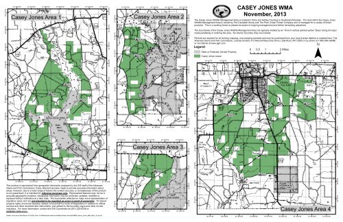
33°39'0"N33°40'0"N33°41'0"N91°38'0"W 91°37'0"W 91°36'0"W 91°35'0"WCase y Jone sAre a191°34'0"W91°33'0"W91°32'0"W33°39'0"N33°40'0"N33°41'0"N33°27'0"N33°28'0"N33°29'0"N91°35'0"W91°34'0"W 91°33'0"W 91°32'0"W 91°31'0"WCase y Jone sAre a2!92-A!9 2-B!y!y33°27'0"N33°28'0"N33°29'0"NCASEY JONES WMANovember, 2013T he Case y Jone sW ild life Manage m e ntAre aisloc ate d in Dre w<strong>and</strong> Ashle y Countie sin Southe ast<strong>Arkansas</strong>.T he l<strong>and</strong> within the Case y Jone sW ild life Manage m e ntAre aisowne d by T he Cam pbe llGroup <strong>and</strong> T he Plum Cre e k T im be rCom pany <strong>and</strong> ism anage d foravarie ty offore stprod uc ts.T hisisaworking fore stso ple ase be aware ofongoing m anage m e nt<strong>and</strong> tim be rharve sting ope rations.T he bound arie softhe Case y Jone sW ild life Manage m e ntAre aare typic ally m arke d by an 18-inc h ve rtic alpainte d ye llow“blaze ”along allm ajorroad sparalle ling ore nte ring the are a.N o inte riorbound ary line sare m arke d .Pe rm itsare re q uire d forallhunting,trapping,<strong>and</strong> c am ping ac tivitie s<strong>and</strong> m ay be purc hase d from yourloc allic e nse d e ale rsorord e re d from :T he<strong>Arkansas</strong>Gam e <strong>and</strong> <strong>Fish</strong> Com m ission,L ic e nse Division,#2N aturalRe sourc e sDrive ,L itle Roc k,AR72205orby phone at1-800-364-GAME¯orviainte rne tatwww.agfc .c om .Legend0 0.5 1 2Mile sState orFe d e rally O wne d Prope rtyCase y Jone sL e ase33°38'0"N33°38'0"N33°26'0"N33°26'0"N92°1'0"W92°0'0"W91°59'0"W91°58'0"W91°57'0"W91°56'0"W91°55'0"W91°54'0"W91°53'0"W33°37'0"N33°36'0"N!91-B!91-A!91-C33°37'0"N33°36'0"N33°25'0"N33°24'0"N!y33°25'0"N33°24'0"N33°8'0"N33°7'0"N!94-A33°8'0"N33°7'0"N33°35'0"N33°34'0"NSe ve n De vilsW MA!y33°35'0"N33°34'0"N33°23'0"N91°35'0"W91°34'0"W91°33'0"W91°32'0"W91°31'0"W33°23'0"N33°6'0"N33°5'0"N!94-B33°6'0"N33°5'0"N91°43'0"W91°42'0"W91°41'0"W91°40'0"W91°39'0"W33°33'0"N!y33°33'0"N33°8'0"NCase y Jone sAre a333°8'0"N33°4'0"N33°4'0"N33°32'0"N33°32'0"N33°7'0"N!9 3-A33°7'0"N33°3'0"N!9 4-C33°3'0"N91°38'0"W91°37'0"W91°36'0"W91°35'0"W91°34'0"W91°33'0"W91°32'0"WT hisprod uc tisre prod uc e d from ge ospatialinform ation pre pare d by the GISstafofthe <strong>Arkansas</strong>Gam e <strong>and</strong> <strong>Fish</strong> Com m ission.Eve ry ate m pthasbe e n m ad e to provid e ac c urate inform ation aboutare as.Howe ve r,d ue to awid e range offac torsthe c onte ntac c urac y orc om ple te ne ssofthisprod uc tisnotguarante e d .Itisinte nd e d fo reference purposes only.Re pre se nte d fe ature sm ay notbe inac c urate ge ographic loc ations.Ge ospatialinform ation m ay be c o re c te d ,upd ate d ,m od ifie d orre plac e d withoutnotific ation atalate rd ate .T he bound arie sre fle c te d on m apsare are pre se ntation ofre gulatory are as<strong>and</strong> are not intended to be regarded as exact or proof of ownership.T o re spe c tprope rty rights<strong>and</strong> avoid tre spass,alwaysc onsultAGFCsCod e ofRe gulationsin ad d ition to o fic ialsurve ys<strong>and</strong> othe rre c ord e d l<strong>and</strong> instrum e nts,<strong>and</strong> ad he re to the bound ary signs<strong>and</strong> othe ron-siteind ic ators.Form ore inform ation,c ontac tthe GISCoord inatorat(501)223-6338orgis@agfc .state .ar.us.33°6'0"N33°5'0"N91°43'0"W91°42'0"W91°41'0"WO V ERFL O W N W R91°40'0"W91°39'0"W33°6'0"N33°5'0"N33°2'0"N33°1'0"NW MACase y Jone sAre a433°2'0"N33°1'0"NAuthor: Scott Lane, Date Saved: 11/7/2013, Path: Y:\GISProjects\Leased L<strong>and</strong> <strong>Map</strong>s\Casey Jones\20120809_Casey_Jones_<strong>Map</strong>_Side1_of_2.mxd92°1'0"W92°0'0"W91°59'0"W91°58'0"W91°57'0"W91°56'0"W91°55'0"W91°54'0"W91°53'0"W
92°2'0"W92°1'0"W92°0'0"W91°59'0"W91°58'0"W91°57'0"W91°56'0"W91°55'0"W91°54'0"W91°53'0"W91°52'0"W91°51'0"W91°50'0"W91°49'0"W91°48'0"W33°33'0"N0 0.475 0.95 1.9 MilesAuthor: SLane, Date Saved: 11/7/2013, Path: Y:\GISProjects\Leased L<strong>and</strong><strong>Map</strong>s\Casey Jones\20120809_Casey_Jones_<strong>Map</strong>_Side2_of_2.mxdCasey Jones Area 533°33'0"N!9 5-A !95-B33°30'0"N!y!95-C33°28'0"N33°28'0"N33°29'0"N33°30'0"N33°29'0"N33°31'0"N33°31'0"N33°32'0"N33°27'0"N33°32'0"N!95-D33°27'0"N33°26'0"N33°25'0"N$!95-E33°26'0"N33°25'0"N33°24'0"N!95-F33°24'0"N33°23'0"NLegendCasey Jones WMAState or Federally Owned Property!y!95-G33°18'0"N33°18'0"N33°19'0"N33°19'0"N33°20'0"N33°20'0"N33°21'0"N33°21'0"N33°23'0"N33°22'0"N33°17'0"N33°22'0"NAREA 133°17'0"NAREA 5AREA 233°16'0"N33°15'0"N33°16'0"N!yAREA 4AREA 333°15'0"N92°2'0"W92°1'0"W92°0'0"W91°59'0"W91°58'0"W91°57'0"W91°56'0"W91°55'0"W91°54'0"W91°53'0"W91°52'0"W91°51'0"W91°50'0"W91°49'0"W