Alafia River North Prong
Alafia River North Prong
Alafia River North Prong

Create successful ePaper yourself
Turn your PDF publications into a flip-book with our unique Google optimized e-Paper software.
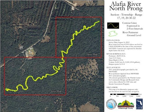
<strong>Alafia</strong> <strong>River</strong><strong>North</strong> <strong>Prong</strong>Section - Township - Range17, 19, 20-30-22Contour LinesExpressed in2-Foot Intervals<strong>River</strong> PerimeterGround LevelEXPLANATION:Survey Date:August 14, 2012<strong>River</strong> water level was 41.99 ft above sea level atUSGS 02301000 at the time of the assessmentNGVD29. Contours are expressed in absolutedepth below this level.Inset Map 2RIVER MORPHOLOGY:Perimeter 28,919.54 ft;Area 15.15 AcresMean Depth 4.32 ft;Volume 16.08 Acre-ft, (5,241,123.8 gallons);Deepest point 16.31 ftDATA SOURCES:2011 aerial photography provided by theSWFWMD.<strong>River</strong> perimeter digitized from SWFWMD2011 aerial photographs.All contours generated by the Florida Centerfor Community Design and Research fromsurvey data collected by USF Lake andStream Assessment Program.Inset Map 1DISCLAIMER:This map is for illustrative purposes only,and should not be used for lake navigation.Feet0 500 1,000 1,500 2,000
<strong>Alafia</strong> <strong>River</strong> <strong>North</strong> <strong>Prong</strong>Inset Map 16446686686164844666666Legend2-Foot ContoursPerimeter0 125 250 500 750 1,000Feet´
<strong>Alafia</strong> <strong>River</strong> <strong>North</strong> <strong>Prong</strong>Inset Map 24646844666644Legend2-Foot Contours4Perimeter640 125 250 500 750 1,000Feet´