LOWER BOX CREEK RESERVOIR - Division of Water Quality
LOWER BOX CREEK RESERVOIR - Division of Water Quality
LOWER BOX CREEK RESERVOIR - Division of Water Quality

You also want an ePaper? Increase the reach of your titles
YUMPU automatically turns print PDFs into web optimized ePapers that Google loves.
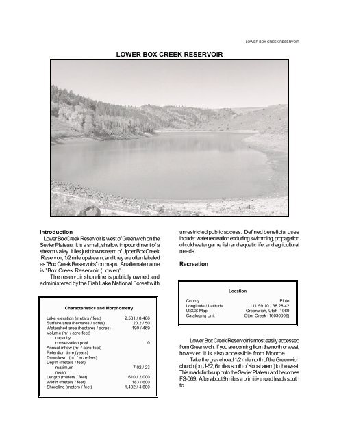
<strong>LOWER</strong> <strong>BOX</strong> <strong>CREEK</strong> <strong>RESERVOIR</strong><strong>LOWER</strong> <strong>BOX</strong> <strong>CREEK</strong> <strong>RESERVOIR</strong>IntroductionLower Box Creek Reservoir is west <strong>of</strong> Greenwich on theSevier Plateau. It is a small, shallow impoundment <strong>of</strong> astream valley. It lies just downstream <strong>of</strong> Upper Box CreekReservoir, 1/2 mile upstream, and they are <strong>of</strong>ten labeledas "Box Creek Reservoirs" on maps. An alternate nameis "Box Creek Reservoir (Lower)".The reservoir shoreline is publicly owned andadministered by the Fish Lake National Forest withCharacteristics and MorphometryLake elevation (meters / feet) 2,581 / 8,466Surface area (hectares / acres) 20.2 / 50<strong>Water</strong>shed area (hectares / acres) 190 / 469Volume (m 3 / acre-feet)capacityconservation pool 0Annual inflow (m 3 / acre-feet)Retention time (years)Drawdown (m 3 / acre-feet)Depth (meters / feet)maximum 7.02 / 23meanLength (meters / feet) 610 / 2,000Width (meters / feet) 183 / 600Shoreline (meters / feet) 1,402 / 4,600unrestricted public access. Defined beneficial usesinclude: water recreation excluding swimming, propagation<strong>of</strong> cold water game fish and aquatic life, and agriculturalneeds.RecreationLocationCountyPiuteLongitude / Latitude 111 59 10 / 38 28 42USGS Map Greenwich, Utah 1969Cataloging Unit Otter Creek (16030002)Lower Box Creek Reservoir is most easily accessedfrom Greenwich. If you are coming from the north or west,however, it is also accessible from Monroe.Take the gravel road 1/2 mile north <strong>of</strong> the Greenwichchurch (on U-62, 6 miles south <strong>of</strong> Koosharem) to the west.This road climbs up onto the Sevier Plateau and becomesFS-069. After about 9 miles a primitive road leads southto
LAKE REPORTSFile Contains Data forPostScript Printers Only
<strong>LOWER</strong> <strong>BOX</strong> <strong>CREEK</strong> <strong>RESERVOIR</strong>Lower Box Creek Reservoir.Access is from Monroe via FS-078. From downtownMonroe, go south, then southeast out <strong>of</strong> town, followingsigns to Monrovian Park. At Monrovian Park, continue onFS-078 as it turns to gravel and climbs to the top <strong>of</strong> theplateau. About 16 miles past Monrovian Park and .5 milesbeyond the 23nd FS-068 junction, the road to Lower BoxCreek Reservoir branches to the right.Fishing, backpacking and camping are possible in thearea. Usage is light. There are no recreational facilities atthe reservoir, although there are pleasant groves <strong>of</strong> aspenfor primitive camping. There are no Forest ServiceCampgrounds in the area, and the nearest privatecampgrounds are in Koosharem and Monroe.<strong>Water</strong>shed DescriptionThe reservoir is in an area <strong>of</strong> high, rolling ridges andvalleys characteristic <strong>of</strong> the Sevier Plateau. Thewatershed high point, Monkey Flat Ridge, is 2,695 m(8,844 ft) above sea level, thereby developing a complexslope <strong>of</strong> 9.0% to the reservoir. Box Creek is the inflow andoutlet for the reservoir. Upper Box Creek Reservoir, anupstream impoundment, is 0.5 miles up Box Creek fromLower Box Creek Reservoir. Above the reservoirs theaverage stream gradient is 8.4% (447 feet per mile).The soil is largely <strong>of</strong> volcanic origin with moderatepermeability and moderately slow erosion and run<strong>of</strong>f.The vegetation communities are comprised <strong>of</strong> aspen,spruce-fir and sage-grass. The watershed receives 51 -76 cm (20 - 30 inches) <strong>of</strong> precipitation annually with afrost-free season <strong>of</strong> 60 - 80 days at the reservoir.Limnological DataData sampled from STORET site:594562Surface Data 1992Trophic StatusHChlorophyll TSI 85.76Secchi Depth TSI 67.36Phosphorous TSI 78.08Average TSI 77.07Chlorophyll a (ug/L) 276.7Transparency (m) 0.6Total Phosphorous (ug/L) 169pH 10Total Susp. Solids (mg/L) 14Total Volatile Solids 13(mg/L)Total Residual Solids
LAKE REPORTSproduction <strong>of</strong> algae during the summer. Macrophytes aretypically not a problem, but they do develop in the westernend <strong>of</strong> the lake in the inlet area later in the summer.According to DWR no fish kills have been reported inrecent years. It should be noted that the reservoir can bedrained late in the fall. The lake has not been treated forrough fish competition, so populations <strong>of</strong> native fishes maystill be present in the lake. The DWR typically stocksLower Box Creek Reservoir with 2,000 catchable rainbowtrout (Oncorhynchus mykiss) and 1,500 fingerlingbrook trout (Salvelinus fontinalis).Phytoplankton in the euphotic zone include thefollowing taxa (in order <strong>of</strong> dominance)SpeciesCell Volume% Density(mm 3 /liter) By Volumeboating and similar recreation (excluding swimming) (2B),cold water game fish and aquatic life (3A) and agriculture(4).Aphanizomenon flos-aquae 116. 20499.79Microcystis aeruginosa .244 0.21Total 116.448Shannon-Weaver [H'] 0.02Species Evenness 0.02Species Richness 0.04The phytoplankton community is dominated by thepresence <strong>of</strong> blue-green algae, indicative <strong>of</strong> highlyeutrophic conditions and poorer water quality.InformationFish Lake National Forest (owners) 896-4491Richfield Ranger District 896-4491Koosharem Campground, Cafe 638-7310Monroe Hot Springs Resort 527-4014Six County Commissioners Association 896-9222<strong>Division</strong> <strong>of</strong> Wildlife Resources 538-4700<strong>Division</strong> <strong>of</strong> <strong>Water</strong> <strong>Quality</strong> 538-6146Pollution AssessmentThe only nonpoint source <strong>of</strong> pollution in Lower BoxCreek Reservoir is sedimentation and nutrient loadingfrom grazing in the watershed and in the vicinity <strong>of</strong> thereservoir. High numbers <strong>of</strong> cattle graze in the vicinity <strong>of</strong>the reservoir for part <strong>of</strong> the summer and fall.There are no point pollution sources in thewatershed.Beneficial Use ClassificationThe state beneficial use classifications include:
<strong>LOWER</strong> <strong>BOX</strong> <strong>CREEK</strong> <strong>RESERVOIR</strong>