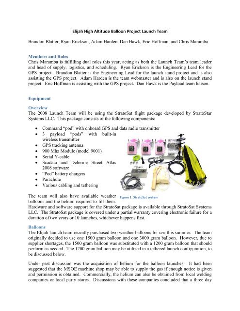
Elijah High Altitude Balloon Project
Elijah High Altitude Balloon Project
Elijah High Altitude Balloon Project

Create successful ePaper yourself
Turn your PDF publications into a flip-book with our unique Google optimized e-Paper software.
Integrated Systems Test: Tethered LaunchThe launch team planned a tethered launch of a balloon with accompanying payload. The goalof the launch was to simulate as closely as possible the preparation, launch checkout, and releaseof the StratoSat system, balloon, and payload as an integrated whole. Recovery was simplifiedby tethering a rope to the payload-balloon system, which was reeled in and out on a spool. Theballoon reached the ideal height of a few hundred feet, and during the ascent the launch teamgained a better understanding of how the balloon behaves before and during the ascent. Thelaunch team utilized the smallest balloon in inventory for this event.The payload team did not have a payload ready by the time this launch was conducted.Therefore, the launch team prepared a simple set of electronics that was used to transmit basic,patterned data from the command pod’s transmitter. This allowed for the testing of all majorfacets of the Stratosat system: the onboard Global Positioning System, the wireless link frompayload pod to command pod, and the transmitter which was responsible for sending all the datato the chase vehicles.All necessary precautionary measures were taken to preserve all aspects of the launch for use onthe actual launch day. This included the balloon to be used, as the working theory was thatrecovery and reuse of the balloon could be achieved by carefully handling the balloon andensuring the balloon is filled properly.The tethered launch was a success, as it helped the team realize all the equipment that wasmissing: the correct size nozzle to the helium tank and a car inverter to provide two outlets froma car lighter. The team also gained greater insight into all the steps involved for preparing theballoon and entire payload system. Flaws in the launch process were identified, analyzed, andrectified, and better estimates of the launch day timeline were developed. This allowed thelaunch team to determine the actual timeline to be used on launch day and understand themargins that existed with scheduling.Launch Day ActivitiesLaunchThe launch team decided on Saturday, August 10 for the day of the launch with the launchlocation being a local soccer field in Chippewa Falls, WI. The site was primarily chosen due toits western distance from Lake Michigan and its rural surroundings. Preparations werescheduled to being at the field by 5:30AM with the launch occurring as soon after that asfeasible. An early launch time was decided on to keep winds to a minimum during the filling theballoon.After arrival, the team began setting up the launch location while accompanying members of thepayload team began preparing the payload. Of primary concern was the balloon filling, and sothis was begun as quickly as possible.The team had decided on a larger 3000 gram balloon the night before in order to under-fill theballoon and obtain a slower ascent rate, which would help the payload cameras obtain morephotos. The filling process was smooth with no mechanical difficulties. However, the amountof time required to fill the balloon was under-estimated between one and two hours. The slow
fill rate has been attributed to the use of a previously used helium tank (lower pressure results inslower flow rate) and possible leaks at the connection between the nozzle of the hose and theballoon. While every effort was made to minimize leakage on fill, it is probably a certainpercentage of helium escaped and slowed the fill rate of the balloon.Figure 5: <strong>Balloon</strong> FillingDuring the filling process, the rest of the StratoStar equipment (command pod, parachute ring,connection tethers, etc.) was laid out and ultimately assembled. Command pod communicationstests took place near the end of the balloon fill process and while the balloon was full, but beforerelease of the hold-down tethers. Both these tests confirmed the GPS system was operationaland transmitting valid location data. The payload team members also confirmed that the camerasand mechanical systems attached to the payload were operational and functioning as expected.At approximately 8:00 AM, a final check of all balloon, recovery, and payload equipment wasperformed. Nothing was found out of order, and the balloon was released shortly thereafter witha final lift of approximately 9 pounds.Tracking and RecoveryAfter launch, members from both the launch team and the payload team began tracking theballoon to determine its initial direction and speed. The balloon began with a mostly southernheading, but quickly began trending south-easterly at a heading of 155 degrees (±10 degrees orso), which was maintained for the majority of the flight.It was decided with this information that the team should head south on I-94 while maintainingdistance from the balloon. The tracking strategy adopted by the team was reactionary in nature,
although a program was used to guess the flight direction of the balloon. The program used theballoon parameters and the weather forecast conditions on the day of launch. Decisionsconcerning where the tracking vehicles should head were made by determining the general trendof the balloon’s course and speed, and determining the best path for continuing to track orintercept the balloon.The balloon’s ascent was characterized by a very rapid climb in altitude during the initial andmain phase of the flight, followed by a slower ascent once the balloon was above the jet stream.Between 30,000 and 50,000 feet, the balloon encountered the jet stream where it reached speedsover 100 miles per hour. Ultimately, the balloon rose above the jet stream and steadily slowed inground speed. After more than three hours of flight, the balloon finally gave out atapproximately 100,000 feet near Sparta, WI. The launch team proceeded to track the descent ofthe balloon and its payload, eventually locating it in Rockland, WI.Figure 6: GPS-Generated Ground Track of <strong>Balloon</strong>'s FlightAfter approximately 1.5 hours, the balloon was located in the branches of a tree approximately40 feet above the ground. Because of the height of the balloon and its entangled state, theowners of the land were eventually contacted and asked to evaluate the situation. It wasultimately decided that the only option to recover the payload was to cut down the tree. Theowners eventually cut down two trees to obtain the payload. The first tree fell down, but was thewrong tree. The balloon and payload were still 40 feet above ground, and in a different tree thaninitially thought. Once the second tree fell, all balloon remnants and payload were obtained. Alldata from the payload was usable, and all camera’s attached were still functioning, even after thecrash landing into tree, crowning the whole <strong>Elijah</strong> balloon experiment as a great success.Flight AnalysisA review of the entire system after the flight showed that the system performed almost flawlesslyduring flight. The GPS system was found to be accurate in its measurements and the payload