SEG 45 Final_qx4 - Society of Economic Geologists
SEG 45 Final_qx4 - Society of Economic Geologists
SEG 45 Final_qx4 - Society of Economic Geologists

Create successful ePaper yourself
Turn your PDF publications into a flip-book with our unique Google optimized e-Paper software.
OCTOBER 2005 • No 63 <strong>SEG</strong> NEWSLETTER 5<br />
Exploring For Deposits Under<br />
Deep Cover Using Geochemistry<br />
Eion M. Cameron †, Eion Cameron Geochemical Inc., Carp, Ontario K0A 1L0, Canada, Matthew I. Leybourne, Department<br />
<strong>of</strong> Geosciences, University <strong>of</strong> Texas at Dallas, Richardson, Texas 75083-0688, USA, and David L. Kelley (<strong>SEG</strong> 1990 F) Newmont<br />
Technical Facility, 10101 E. Dry Creek Rd., Englewood, Colorado 80112<br />
INTRODUCTION<br />
In a recent article in the <strong>SEG</strong> Newsletter, Roy Woodall drew attention to the challenge<br />
<strong>of</strong> finding ore deposits under deep cover. He highlighted the importance <strong>of</strong><br />
structure: “…recognition <strong>of</strong> pathways for magma and fluid transport is highly relevant<br />
for effective ore search under deep cover. Structures not only focus the transport<br />
<strong>of</strong> ore metals and the ubiquitous carbon and sulfur, they also focus energy,<br />
which is the most critical and <strong>of</strong>ten forgotten essential component for the genesis<br />
<strong>of</strong> a major ore deposit” (Woodall, 2005).<br />
Over the period 1999 to 2002, the Canadian Mining Industry Research<br />
Organization (CAMIRO), supported by 26 companies, sponsored the project<br />
“Deep-Penetrating Geochemistry” to provide the mining industry with knowledge<br />
about processes that may form anomalies at surface over buried deposits, and to<br />
provide comparative data on methods used to detect these anomalies. The study<br />
areas were the porphyry belt <strong>of</strong> northern Chile, the Carlin belt <strong>of</strong> Nevada, and the<br />
Abitibi belt <strong>of</strong> Ontario. In Chile and Nevada, both seismically active regions, the<br />
work demonstrated the importance <strong>of</strong> structure and recent tectonism in the formation<br />
<strong>of</strong> anomalies, bearing out Woodall’s remarks. Here we discuss the influence <strong>of</strong><br />
structure on surface anomalies at the Mike gold-copper deposit, Nevada, and at<br />
the Spence copper deposit, Chile—work that is described in more detail by<br />
Cameron et al. (2004), and Cameron and Leybourne (2005).<br />
<strong>45</strong>18000N<br />
† Corresponding author: e-mail, eioncam@attglobal.net<br />
300 m<br />
Soap Creek Fault Zone<br />
563000E 564000E<br />
High-Grade Cu<br />
D-Day Fault<br />
A<br />
Hillside Fault<br />
WEST<br />
MIKE<br />
Lower-Grade Cu<br />
B<br />
Soil Sampling<br />
Line<br />
Roberts Mountain Thrust<br />
MAIN<br />
MIKE<br />
Good Hope<br />
Fault<br />
1a 1b<br />
Nebulous Fault Zone<br />
N-P Dog Fault<br />
C<br />
<strong>45</strong>18000N<br />
300 m<br />
Soil Sampling Line<br />
563000E<br />
28 o<br />
A<br />
MIKE DEPOSIT<br />
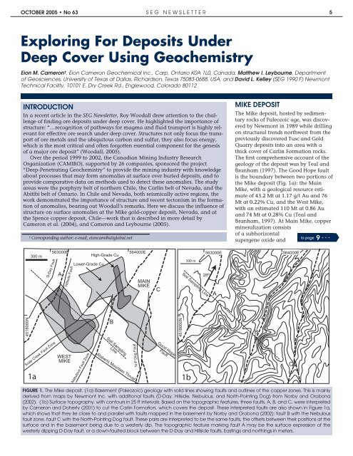
The Mike deposit, hosted by sedimentary<br />
rocks <strong>of</strong> Paleozoic age, was discovered<br />
by Newmont in 1989 while drilling<br />
on structural trends northwest from the<br />
previously discovered Tusc and Gold<br />
Quarry deposits into an area with a<br />
thick cover <strong>of</strong> Carlin Formation rocks.<br />
The first comprehensive account <strong>of</strong> the<br />
geology <strong>of</strong> the deposit was by Teal and<br />
Branham (1997). The Good Hope fault<br />
is the boundary between two portions <strong>of</strong><br />
the Mike deposit (Fig. 1a): the Main<br />
Mike, with a geological resource estimate<br />
<strong>of</strong> 43.2 Mt at 1.17 g/t Au and 76<br />
Mt at 0.22% Cu, and the West Mike,<br />
with an estimated 110 Mt at 0.86 Au<br />
and 74 Mt at 0.28% Cu (Teal and<br />
Branham, 1997). At Main Mike, copper<br />
mineralization consists<br />
<strong>of</strong> a subhorizontal<br />
to page<br />
supergene oxide and 9 ...<br />
B<br />
564000E<br />
FIGURE 1. The Mike deposit. (1a) Basement (Paleozoic) geology with solid lines showing faults and outlines <strong>of</strong> the copper zones. This is mainly<br />
derived from maps by Newmont Inc. with additional faults (D-Day, Hillside, Nebulous, and North-Pointing Dog) from Norby and Orobona<br />
(2002). (1b) Surface topography, with contours in 25 ft intervals. Based on the topographic features, three faults, A, B, and C, were interpreted<br />
by Cameron and Doherty (2001) to cut the Carlin Formation, which covers the deposit. These interpreted faults are also shown in Figure 1a,<br />
which shows that they lie close to and parallel with faults mapped in the basement by Norby and Orobona (2002): fault B with the Nebulous<br />
fault zone, fault C with the North-Pointing Dog fault. These pairs are interpreted to be the same faults, the <strong>of</strong>fsets between their positions at the<br />
surface and in the basement being due to a westerly dip. The topographic feature marking fault A may be the surface expression <strong>of</strong> the<br />
westerly dipping D-Day fault, or a down-faulted block between the D-Day and Hillside faults. Eastings and northings in meters.<br />
C