Two tarns _Borrowdale_.pdf - Walk4Life
Two tarns _Borrowdale_.pdf - Walk4Life
Two tarns _Borrowdale_.pdf - Walk4Life

Create successful ePaper yourself
Turn your PDF publications into a flip-book with our unique Google optimized e-Paper software.
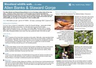
<strong>Two</strong> Tarns Walk – 5 ½ milesSeathwaite to Sty Head & Grains GillThis invigorating walk takes you into the heart of the Lake District hills on anancient pack horse route. Renowned peaks like Great Gable loom large as youfollow the trail through Sty Head Pass, visiting Sty Head Tarn and Sprinkling Tarn(great picnic spots), before returning alongside Grains Gill stream. Enjoy fantasticviews on paths restored and maintained as part of the ‘Fix the Fells’ project.Start & finish: Seathwaite – grid ref: NY 235121 – OS Landranger 90 or Explorer Ol4Getting thereBy foot: the Cumbria Way, from Ulverston to Carlisle, passes close to the start of the walkBy bus: regular bus service to Seathwaite from Keswick and ButtermereBy road: from Keswick take the B5289 <strong>Borrowdale</strong> road; follow this up the valley toSeatoller, turn left and follow a single track road to Seathwaite Farm; car parking isavailable on the road side.FacilitiesWC, public phone box, café and campsite located at Seathwaite Farm.Things to look out for…t Stockley BridgeThis historic packhorse bridge was constructed in 1540, but partially demolished afterfloods in 1969. It’s actually designated as a grade one listed ‘building’ because thereare so few such old bridges in the area. Goods like salt, wool and charcoal weretransported by pack animals through the Lakeland valleys on mountain passes like thisfor centuries.t Great EndThe sheer rock face of Great End rises up beyond the <strong>Two</strong> Tarns at the head of the<strong>Borrowdale</strong> Valley. Man has lived in this landscape for 1000s of years – the remains ofNeolithic stone axe factories have been found dotted across the slopes around here.t Sprinkling TarnThis beautiful tarn below Great End is a nursery for the vendace; Britain’s rarestfreshwater fish. The vendace is a small fish with a bluish green back and silvery flanks.It’s a relic from the last glacial period which only survives in the watercourses that flowinto Derwent Water and Bassenthwaite Lake.Look out for the mountain ringletbutterfly. It can be seen flutteringaround the slopes here on sunnydays throughout the summer. Itis a dark brown butterfly with astriking row of black-centredorange eyespots on its wings.© NT / Matthew OatesThe rare evergreen alpine plant,the dwarf cornel (or bunchberry)likes to live in cool spots onshady mountainous slopes or indark woodland. As our climatebegins to get warmer, it isstruggling to survive.© NTTowards the top of Sty Head Passlies a huge rock, known as the‘1000ft boulder’. It’s a great placeto enjoy views of the waterfall,Taylor Gill Force, which lies to theright of it.© NT / Paul Delaney“On a damp day, nothing beats the sudden glimpse of ahigh peak as mists and low cloud move through these deepLakeland valleys. This walk offers a real sense of mysteryand adventure whatever the season.”John Atkinson, ‘Fix the Fells’ Project Manager
Walk terrain & accessibility5 ½ mile (9km) walk involving 530m ascent and descent – can be fairlystrenuous in all weathers. Sections of this route have recently beenlevelled with stone and include a few steep rock steps. Good boots andwaterproofs needed.Directions1. Cross Seathwaite farmyard, going through a series of gates. Walkalong a streamside gravel track over a small footbridge.2. On reaching Stockley Bridge, continue straight ahead and beginclimbing up Sty Head Pass on cobbled and stone-pitched paths.3. Follow this route, which after a short distance becomes a narrowgravel track on more level but still uneven ground. The footbridge overSty Head Gill appears in front of you.4. Cross the bridge then bear left, ascending gently towards Sty HeadTarn. Great Gable rises up to your right.5. Just above the Tarn you will see a mountain rescue stretcher box.From here walk left across stepping stones and on to another stonepitchedpath with some sections of gravel and bedrock. Follow this toSprinkling Tarn, a pleasant spot to rest for a bite to eat.6. Leave Sprinkling Tarn and follow the same path as it skirts around thebottom of Great End until meeting Ruddy Gill, a fairly steep stream.7. At Ruddy Gill turn left and cross the stream. Continue straight aheadand you will soon get back onto the path on Grains Gill again. On aclear day there are great views of the <strong>Borrowdale</strong> valley and DerwentWater from here.8. Follow this path downhill, crossing a footbridge on the way. Eventuallyyou’ll reach a drystone wall. Go through a gate in the wall and look outagain for Stockley Bridge ahead. Return to it and then to your startpoint by the same streamside route you came up.National Trust places nearby: <strong>Borrowdale</strong> Valley, Great Gable, the Scafell MassifThe Lake District is one of the most beautiful places in the world, however its paths are extremely fragile and over time have been eroded by wind,rain, ice and people. The Fix the Fells project, with the help of The National Trust, is working to repair these damaged paths.Find out more at www.nationaltrust.org.uk and www.fixthefells.co.uk