ÑкаÑаÑÑ
ÑкаÑаÑÑ
ÑкаÑаÑÑ

You also want an ePaper? Increase the reach of your titles
YUMPU automatically turns print PDFs into web optimized ePapers that Google loves.
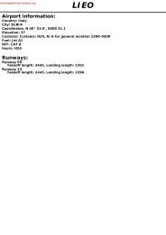
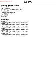
Downloaded from rutracker.orgAirport information:Country: Russian FederationCity: OMSKCoordinates: N 54° 58.0', E073 18.6Elevation: 312Customs: Customs: H24Fuel: TS-1 (Equivilant to Jet A1)RFF: CAT 8hours: H24UNOORunways:Runway 07Takeoff length: 2400, Landing length: 2500Runway 25Takeoff length: 2400, Landing length: 2500
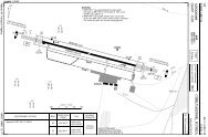
If you like to use this charts, please, buy a subscription for nDAC.For rutracker.orgAERODROME10 - 1 24 JUL 13Omsk APN GND Taxiing TWR Start RAD 1 ATIS Reserve118.8 121.7 119.0 119.0 126.4 124.0AD Elev 312 ARP: N54 58.0 E073 18.6 RFF: CAT 7 AD HR: H24Russia - UNOO / OMSTsentralnyOMSK10 - 1E073 17 E073 18 E073 19 E073 201Additionally serves as APPCoord based on PZ-90.0212ENDB R2501x45m8205x147ft065° 245°ELEV 312D328CCApronTHR CoordinatesRWY 07 N54 57.9 E073 17.5RWY 25 N54 58.2 E073 19.8METerminalBAISMET394Hangar495AELEV 29407 256NDB T715/33 Grass2132x262ft650x80mN54580 500 1000m0 1000 2000 3000 4000ft479N5457RWY Slope TORA m/ ft LDA m/ ft ALS REDL Additional07 - 0.2 2400 / 7873 2500 / 8202 L-E L P 3°25 +0.2 2400 / 7873 2500 / 8202 L-E L P 3°Navtech - unoo01laorg0EU OPSRWY07/25TAKE OFF MINIMAFacilitiesRCL (day only) or RCL + REDLNIL (day only)RVRA B C D400m500mChange: Grass TWY 6A withdrawn, APN freqTHIS CHART IS A PART OF NAVIGRAPH CHARTS AND IS INTENDED FOR FLIGHT SIMULATION USE ONLY
If you like to use this charts, please, buy a subscription for nDAC.For rutracker.org10 - 224 JUL 13Russia - UNOO / OMSAERODROME ParkingTsentralny OMSKOmsk APN GND Taxiing TWR Start RAD 1 ATIS Reserve118.8 121.7 119.0 119.0 126.4 124.0CMC2324181726ApronTerminal10 - 2RWY 07/25E340AISMETBBHangarNavtech -unoo02laorg0Coord based on PZ-90.021 Additionally serves as APPA6727H1H234Parking position coordinates10 N54 57.6 E073 18.914 N54 57.5 E073 18.8Change: Grass TWY 6A withdrawn, APN freqTHIS CHART IS A PART OF NAVIGRAPH CHARTS AND IS INTENDED FOR FLIGHT SIMULATION USE ONLY
If you like to use this charts, please, buy a subscription for nDAC.For rutracker.orgGENERAL10 - 324 JUL 13Russia - UNOO / OMSTsentralny OMSKunoo03gaorg0© Navtech -1. WARNINGBird Hazard.GENERAL2. ALTIMETER SETTING2.1 Trans Hgt and ATC clearances are inMeters QFE (relative to THR). QNHavailable on request.Standard ICAO FL (feet) system usedAbove TA/TL.2.2 TL 30 when pressure is 1049.2 hPa(787mm) or above.TL 40 when pressure is between 1047.9-978.6 hPa (786-734mm).TL 50 when pressure is 977.3 hPa(733mm) or below.3. NOISE ABATEMENT3.1 Restriction for TKOF and LDG of Tu-134(except scheduled fl ights), Tu-154B,Il-76 ACFT established during night time(16-23).3.2 TKOF procedure:TKOF and climbing to 450m/1790ft:- TKOF power of all engines;- fl aps are set into take-off position;- climbing at IAS V 2+11-22 nm/hThe initial turn shall be carried out at aheight not below 1630ft (except ALODA 3,KOVEN 3B, LUSOV 3B procedures).At 1790ft:- maintaining the positive vertical rateof climb reduces engines power tonominal value.From 1790ft to 3270ft:- climbing shall be executed at IASV 2+11-22 nm/hAt 3270ft:- aircraft speed shall be accelerated toa speed when the wing devices to beretracted;- retract wing devices;- further climb to fl ight altitude (fl ightlevel) shall be carried out at a speedas per the Aeroplane Flight Manual.3.3 Restrictions.The procedures are not applied in caseswhen:- one of the engines failure during takeoff;- the runway is dirty and wet;- the horizontal visibility is less than2000m;- cross-wind component (includinggusts) exceeds 26ft/sec;- tail-wind component (including gusts)exceeds 7ft/sec;- when wind shear is forecastedor reported, or it is expected thatthunderstorms may infl uence theconditions of aircraft take-off andclimbing.3.4 TKOF in direction of the city prohibitedunder all weather conditions Irrespective ofday or night, in order to reduce noise.4. RWY RESTRICTIONFirst 100m/328ft not avbl for TKOF.5. TWY RESTRICTIONSTWY C, 6: width 16m/52ft.TWY D: width 19m/62ft.TWY A, B, C, (unpaved segments) and 7:width 20m/66ft.6. TAXI RESTRICTIONS6.1 Taxiing into all stands shall be carried outunder own engines power.6.2 Taxiing of Il-76 aircraft into stands 21, 22shall be carried out via stand 23.6.3 Aircraft shall be escorted by “Follow-me”vehicle equipped with light signalingdevices and radio station in Cases:- When visibility is less than 400 m;- At night for stands 0-23;- At night for stands of local airlines bycrew’s request.6.4 When there is an aircraft on adjacent standwith X-axis directed at an angle towardsthe aircraft taxiing out, exit shall be carriedout only by towing.10 - 3THIS Change: CHART Grass IS A TWY PART 6A OF withdrawn NAVIGRAPH CHARTS AND IS INTENDED FOR FLIGHT SIMULATION USE ONLY
If you like to use this charts, please, buy a subscription for nDAC.For rutracker.orgGENERAL10 - 424 JUL 13Russia - UNOO / OMSTsentralny OMSK10 - 46.5 Taxi routes along TWY 6, 7 are notvisible in full by the taxiing controller. Theresponsibility for the observance of taxiingrules rests with the pilot-in-command.6.6 Taxiing during winter conditions:The taxi guide lines may be invisible dueto snow. “Follow-me” vehicle may berequested by the crew from the taxiingcontroller.6.7 Taxiing of Il-76 and Tu-204 aircraft on theapron are prohibited.6.8 Taxiing of ACFT along TWY C shallbe carried out along the centreline at aminimum speed.6.9 Taxiing of II-76, II-18, An-12 ACFT shall becarried out at idle power.Taxiing of ACFT with low mounted enginesalong TWY C is prohibited, only towing isallowed.6.10 Taxiing of B737 (all modifi cation), A-319,A-320 ACFT under own engines power intostands 0-3 is permitted after “FOLLOW ME”vehicle only.7 PARKINGApron stands 0-7 are available for parkingof transits helicopters.© Navtech -unoo04gaorg0THIS Change: CHART Grass IS A TWY PART 6A OF withdrawn NAVIGRAPH CHARTS AND IS INTENDED FOR FLIGHT SIMULATION USE ONLY
UTARUIf you like to use this charts, please, buy a subscription for nDAC.For rutracker.orgAREA20 - 1 24 JUL 13Omsk RAD 1 TWR Start GND Taxiing ATIS Reserve119.0 119.0 121.7 126.4 124.0Russia - UNOO / OMSTsentralnyChapayev 740 MLOMSKTL 2 TA 2290 AD Elev 312OKETIOKETIOSMIKOSMIKBARKI1 Additionally serves as APP2 TLTLTL287°LOGMABazhenovoN55 47.2E071 55.7520 LFN55 38.1DORONE073 06.4 N55 36.0R480E073 38.9258° 64 076°VERID254°130405057 105°030°B236at or above 1049.2 hPabetween 1047.9-978.6 hPabelow 977.3 hPaA357304°54 073°R9943 123°280° 098°A231210°B81258271° 089°55286° 104°55B814FL100FL50N55 23.5E073 10.7MANUGBUNETFL100FL50N55 09.6E072 41.6NANOLFL100FL50N54 56.3E072 32.2158°FL100FL50N55 16.5E072 48.0338°14.6 158°338°265°POGIRFL100FL50N55 21.4E073 31.218.4185°205°15.1 005°A306RUMODN55 18.2E073 48.2KOVEN1ALPHA47 025°084°FL100FL50N55 07.9E073 15.6R70641 002°182°262°5.4A84419.4FL100FL50N55 02.5E074 04.4Coord based on PZ-90.02R480081°208°LUSOVN54 57.9E074 04.5A844FL100FL5016.7028°BIKMIN55 22.2E073 54.2264°URUKIN55 34.8E074 12.8ATC252° B20193 069°262° 123 078°A357ATCR48065082°OLAPAABESA20 - 1ALPHANavtech - unoo01taorg0102°Astana FIR UACCALPHAOmsk FIR UNOO282°202°R70632 021°DAKINN54 09.5E072 24.3RussiaKazakhstanALODAFL100FL50N54 36.7E072 54.40 5 10nmmQFE600ftQNH229024ARPReverse side blankChange: Coordinate, NANOL, AWY, Dist, MT, WPTTHIS CHART IS A PART OF NAVIGRAPH CHARTS AND IS INTENDED FOR FLIGHT SIMULATION USE ONLY
347°22.7If you like to use this charts, please, buy a subscription for nDAC.For rutracker.orgChange: NANOL 1THIS CHART IS A PART OF NAVIGRAPH CHARTS AND IS INTENDED FOR FLIGHT SIMULATION USE ONLYNavtech - unoo01daorg0Omsk GND Taxiing TWR Start121.7 119.0TA 2290 AD Elev 3121 Additionally serves as APPmQFE600400ftQNH22901630BUNETN55 09.6E072 41.6NANOLN54 56.3E072 32.2RAD 1 ATIS Reserve119.0 126.4 124.0MANUGN55 16.5E072 48.0ALODAN54 36.7E072 54.4234°264°NANOL 128.6ALOD1A287°BUNET 121.1187°VERIDN55 23.5E073 10.7MANUG 119.435ALODA 1AALOD1B182°950 RM319°N54 57.4E073 13.834ALODA 1B216°ATCVERID 128.1290°13N55 07.2E073 17.95.41630065°R1191FL50NOTAMPOGIR 1POGIRN55 21.4E073 31.220.5 068°ATC0 5 10nm30 - 1MNM CLIMB GRADIENT3.7% upto 1630.Or TKOF Min:For CAT A/B : Vis 2300m & ceiling 1090ft.For CAT C/D : Vis 2400m & ceiling 1150ft.with visual avoidance of 1280ft obst.KOVEN 1Coord based on PZ-90.02LUSOV 120.5 081°ATC24ARPKOVENN55 02.5E074 04.4LUSOVN54 57.9E074 04.5SID RWY 07TsentralnyOMSK30 - 124 JUL 13Russia - UNOO / OMS
If you like to use this charts, please, buy a subscription for nDAC.For rutracker.orgSID RWY 2530 - 224 JUL 13Russia - UNOO / OMSTsentralnyOMSKOmsk GND Taxiing TWR Start RAD 1 ATIS Reserve121.7 119.0 119.0 126.4 124.01 Additionally serves as APPMANUGN55 16.5E072 48.0m ftQFE QNHBUNETN55 09.6E072 41.6258° 21.1NANOLN54 56.3E072 32.2300°20.5321°23.8TA 2270 AD Elev 312600400200Scale distortedBUNET 322701610950NANOL 330 - 2ALODAN54 36.7E072 54.4ALODA 3190°22.71610MANUG 3VERID 328.6 356°1.113 022°Navtech - unoo02daorg0VERIDN55 23.5E073 10.7POGIRN55 21.4E073 31.2N55 06.6E073 13.9KOVENN55 02.5E074 04.4LUSOVN54 57.9E074 04.5245°23.8 056°22.7 068°950 TKN54 58.7E073 24.4N54 54.5E073 26.00 5 10nmARP15.1 065°ATCLUSO3B95024335°LUSOV 3BATC3.2KOVE3BKOVEN 3B31 096°LUSO3ALUSOV 3AATC131°29.7 087°KOVE3AKOVEN 3AATCPOGIR 318.4Coord based on PZ-90.02Change: NANOL 3THIS CHART IS A PART OF NAVIGRAPH CHARTS AND IS INTENDED FOR FLIGHT SIMULATION USE ONLY
STAR RWY 07140 - 124 JUL 13KOVEN LUSOV KOVEN LUSOVATC257°29.24570077°4LUSO2ARussia - UNOO / OMSTsentralnyOMSKPOGIRAdditionally serves as APPCoord based on PZ-90.02POGIR 2B202°16.24570POGI2BKOVE2BALPHA174° to RM205°28.1277°29.7N55 07.9E073 15.6AtVERID3By ATCATCN54 56.7E073 08.8MANUGTL 2 AD Elev950 RMN54 57.4E073 13.8680 RN54 57.7E073 16.5453POGI2AKOVEN 2B268°457028.64570POGIR 2AATCLUSOV 2BLUSO2B20 146°BUNETN55 09.6E072 41.63m ftQFE QNH11.945704570KOVE2AKOVEN 2A247°ATC29.74570065° 245°FAF/FAPOmsk/SevernyLUSOV 2A1960If you like to use this charts, please, buy a subscription for nDAC.IAFFor rutracker.orgCAT A/B - 1min 30sec.CAT C/D - 1min.All CAT ACFT - 1min 15sec.24ARPNavtech - unoo01aaorg0Omsk RAD 1 TWR Start GND Taxiing ATIS Reserve119.0 119.0 121.7 126.4 124.03124530457025.9180°VERID 2MANUG 245704530BUNET 245704530316.7 125°210°229019606005002290AtN54 58.4E073 00.822290AtTL 30 at or above 1049.2hPa.TL 40 between 1047.9-978.6hPa.TL 50 below 977.3hPa.2290AtN54 59.0E073 01.35091°N54 57.7E073 00.8290°086°2.7081°At110°N54 57.2E073 01.1058°AtAt18.9 078°45704270 3N54 56.2E073 04.4 AtN54 56.4E073 03.4NANOLN54 56.3E072 32.2N54 55.2E073 03.4319.4 003°Change: NANOL 2THIS CHART IS A PART OF NAVIGRAPH CHARTS AND IS INTENDED FOR FLIGHT SIMULATION USE ONLY2290NANOL 2IF19601960196045704270ALODA 20 5 10nmALODA40 - 1
3.2If you like to use this charts, please, buy a subscription for nDAC.For rutracker.orgILS OR NDB RWY 0750 - 1Omsk RAD 1 TWR Start GND Taxiing ATIS119.0 119.0 121.7 126.409 JAN 13Reserve124.0Russia - UNOO / OMSTsentralny1 Additionally serves as APPOMSKPANS OPSILS 108.3 IRM /NDB 950 RM FAT 065° THR Elev 312 11hPa AD Elev 312 11hPa TL 2 TA 2280E072 50 E073 00 E073 10 E073 20 E073 3012E2 TL 30 at or above 1049.2 hPaCoord based on PZ-90.02TL 40 between 1047.9-978.6 hPaTL 50 below 977.3 hPaALPHAmQFE600500400210ftQNH228019601630101051060QNH=QFE+11hPa24ARPAt2280290°110°065°363091°210°13.5853BRAVO1190At069° to RM2.7N54 56.7E073 08.81960030°11931234N54 56.7E073 08.8 472ILS108.3 IRM182°210°950 RM497412984680 RAt290°4414794942280134664157125.4561761R1191FL50NOTAM128310nmOmsk/Severny1630404379N5510N5500R1192FL59 GNDNOTAMN545050 - 1SeeChartAt1960FAF by SARN54 56.7E073 08.8065°3°1010RM510RMAPt 2NDB : 1.3nm after RMClimb on 065° to 1630 with climb gradient3.7% to 5.4nm from THR25, turn left on 290°climbing to 2280 , then as diercted by ATC.unoo01iaip00EU OPSNavtech -nm 7 6 5 4 3 2 1 0ACFT ILS 3.7% 2NDB 3.7% 2NDB 3.7% NDB 3.7% GS 80 100 120 140 160a a b a a ROD 2.8° 390 490 590 690 790ARM +20s 880 850 810 780 7501020 (709) 1020 (709)+40s 750 680 - - -B 520 (200) 670 (350) 1500m 1500m+60s - - - - -1000m 1400mCRM- 670 0:54 0:43 0:36 0:31 0:271020 (709) 1020 (709)D2400m 2400mNote: Circling NA. a MISAP MNM Climb gradient.b With FAF.TCH 49LDA 2500x458202x147ftP 3°BALSChange: New specTHIS CHART IS A PART OF NAVIGRAPH CHARTS AND IS INTENDED FOR FLIGHT SIMULATION USE ONLY
If you like to use this charts, please, buy a subscription for nDAC.For rutracker.orgILS OR NDB RWY 2550 - 2Omsk RAD 1 TWR Start GND Taxiing ATIS119.0 119.0 121.7 126.409 JAN 13Reserve124.0Russia - UNOO / OMSTsentralny1 Additionally serves as APPOMSKPANS OPSILS 110.1 ITK /NDB 950 TK FAT 245° THR Elev 294 11hPa AD Elev 312 11hPa TL 2 TA 2270E073 00 E073 10 E073 20 E073 30 E073 4012E2 TL 30 at or above 1049.2 hPaTL 40 between 1047.9-978.6 hPaALPHATL 50 below 977.3 hPamQFE600400280ftQNH22701610122053070QNH=QFE+11hPaAt1610227013 022°853102°119011934.3131°1324472282°680 T41249798449412.4 102°479712At1283N54 59.5466 E073 30.0441415245°561761950 TKWarningTurbulence with down draughtmaybe experienced on final.2270218°3.2241°200°N54 59.8E073 32.1 AtOmsk/SevernyILS110.1 ITKCoord based on PZ-90.02379020°2270N5510CHARLIEN550050 - 2Warning363 Bird Hazard is obeservedbetween LMM & LOM inR1191FL50warm season.NOTAMMAPt 2NDB : 0.9nm before TKTTKN54 59.5E073 30.0Climb on 245° to 1610, at 4.3nmfrom THR turn right on 022° climbingto 2270 , then as directed by ATC.3°40410nm245°R1192FL59 GNDNOTAM24ARPAt2270N5450SeeChart5301220FAF by SARunoo02iaip00EU OPSTCH 540 1 2 3 4 5 6 7 8 nmACFT ILS 2NDB a 2NDB NDBLDA 2500x458202x147ftAP 3°B 500 (200) 1530 (1234) 1780 (1476) 1780 (1476)1000mC5000m 5000m 5000mNavtech -DNote: Circling NA.a With FAF.BALSChange: New specTHIS CHART IS A PART OF NAVIGRAPH CHARTS AND IS INTENDED FOR FLIGHT SIMULATION USE ONLY