View File - Development Services - City of Oxnard
View File - Development Services - City of Oxnard View File - Development Services - City of Oxnard
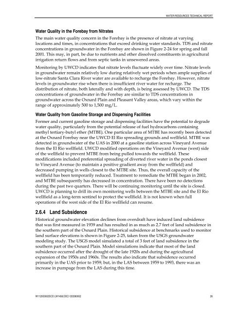
WATER RESOURCES TECHNICAL REPORTWater Quality in the Forebay from NitratesThe main water quality concern in the Forebay is the presence of nitrate at varyinglocations and times, in concentrations that exceed drinking water standards. TDS and nitrateconcentrations in groundwater in the Forebay are shown in Figure 2-24 for spring and fall2001. This may, in part, be due to nutrients and other dissolved constituents in agriculturalirrigation return flows and from septic tanks in unsewered areas.Monitoring by UWCD indicates that nitrate levels fluctuate widely over time. Nitrate levelsin groundwater remain relatively low during relatively wet periods when ample supplies oflow-nitrate Santa Clara River water are available to recharge the Forebay. However, nitratelevels in groundwater rise when there is insufficient river water for recharge. Thedistribution of nitrate, both laterally and with depth, is being assessed by UWCD. The TDSconcentrations of groundwater in the Forebay are similar to TDS concentrations ingroundwater across the Oxnard Plain and Pleasant Valley areas, which vary within therange of approximately 500 to 1,500 mg/L.Water Quality from Gasoline Storage and Dispensing FacilitiesFormer and current gasoline storage and dispensing facilities have the potential to degradewater quality, particularly from the potential release of fuel hydrocarbons containingmethyl tertiary-butyl ether (MTBE). One particular area of MTBE has recently been detectedat the Oxnard Forebay near the UWCD El Rio spreading grounds and wellfield. MTBE wasdetected in groundwater of the UAS in 2000 at a gasoline station across Vineyard Avenuefrom the El Rio wellfield. UWCD modified operations on the Vineyard Avenue (west) sideof the wellfield to prevent MTBE from being pulled towards the wellfield. Thesemodifications included preferential spreading of diverted river water in the ponds closestto Vineyard Avenue (to maintain a positive gradient away from the wellfield) anddecreased pumping in wells closest to the MTBE site. Thus, the overall capacity of thewellfield has been temporarily reduced. Treatment to remediate the MTBE began in 2002,and MTBE subsequently has decreased in concentration. There have been no detectionsduring the past two quarters. There will be continuing monitoring until the site is closed.UWCD is planning to drill its own monitoring wells between the MTBE site and the El Riowellfield as a long-term sentinel to protect the wellfield. It is not known when fulloperations of the west side of the El Rio wellfield can resume.2.6.4 Land SubsidenceHistorical groundwater elevation declines from overdraft have induced land subsidencethat was first measured in 1939 and has resulted in as much as 2.7 feet of land subsidence inthe southern part of the Oxnard Plain. Historical subsidence at benchmarks used to monitorland surface elevations is shown in Figure 2-25, taken from the USGS groundwatermodeling study. The USGS model simulated a total of 3 feet of land subsidence in thesouthern part of the Oxnard Plain. Model simulations indicate that most of the landsubsidence occurred after the drought of the late 1920s and during the agriculturalexpansion of the 1950s and 1960s. The results also indicate that subsidence occurredprimarily in the UAS prior to 1959; but, in the LAS between 1959 to 1993, there was anincrease in pumpage from the LAS during this time.W112003002SCO LW1458.DOC/ 033390002 26
Figure 2-1Groundwater Basins and theSanta Clara-CalleguasHydrologic UnitCity of Oxnard GREAT ProgramSource: USGS, 2003W032003002SCO176466.GP.06 OG03a ai 11/03
- Page 4 and 5: CONTENTS6.2.2 Base Case and Phase 1
- Page 6 and 7: CONTENTSFiguresSection 1.0 - Introd
- Page 8 and 9: AcronymsACPAFYASRAWTFBasin PlanbgsB
- Page 10: 1.0 IntroductionThis Technical Repo
- Page 13 and 14: WATER RESOURCES TECHNICAL REPORT•
- Page 15 and 16: SANTA BARBARACOUNTYSanta BarbaraVEN
- Page 17 and 18: WATER RESOURCES TECHNICAL REPORT2.2
- Page 19 and 20: WATER RESOURCES TECHNICAL REPORTmul
- Page 21 and 22: WATER RESOURCES TECHNICAL REPORT2.4
- Page 23 and 24: WATER RESOURCES TECHNICAL REPORTof
- Page 25 and 26: WATER RESOURCES TECHNICAL REPORTFor
- Page 27 and 28: WATER RESOURCES TECHNICAL REPORTThe
- Page 29 and 30: WATER RESOURCES TECHNICAL REPORTThe
- Page 31 and 32: WATER RESOURCES TECHNICAL REPORTres
- Page 33 and 34: WATER RESOURCES TECHNICAL REPORTPum
- Page 35: WATER RESOURCES TECHNICAL REPORTdis
- Page 39 and 40: Figure 2-3Groundwater Basins andUWC
- Page 41 and 42: 604020Precipitation (inches)0-20189
- Page 43 and 44: Note: Generalized surficial geology
- Page 45 and 46: (a) Groundwater Elevation Monitorin
- Page 47 and 48: Figure 2-11DWR 1976Schematic CrossS
- Page 49 and 50: 02N22W12R01S02N22W22M04SVineyard Av
- Page 51 and 52: Figure 2-15USGS Groundwater LevelHy
- Page 53 and 54: Figure 2-17USGS Groundwater LevelHy
- Page 55 and 56: (a) Groundwater Elevations, LAS, Sp
- Page 57 and 58: (a) Total Dissolved Solids, UAS, 20
- Page 59 and 60: (a) Chloride Concentrations, Oxnard
- Page 61 and 62: Figure 2-25Subsidence onthe Oxnard
- Page 63 and 64: WATER RESOURCES TECHNICAL REPORTAgr
- Page 65 and 66: WATER RESOURCES TECHNICAL REPORTto
- Page 67 and 68: WATER RESOURCES TECHNICAL REPORTOxn
- Page 69 and 70: WATER RESOURCES TECHNICAL REPORTGro
- Page 71 and 72: WATER RESOURCES TECHNICAL REPORThis
- Page 73 and 74: WATER RESOURCES TECHNICAL REPORTsou
- Page 75 and 76: WATER RESOURCES TECHNICAL REPORTPro
- Page 77 and 78: WATER RESOURCES TECHNICAL REPORTPro
- Page 79 and 80: WATER RESOURCES TECHNICAL REPORTove
- Page 81 and 82: WATER RESOURCES TECHNICAL REPORTout
- Page 83 and 84: TABLE 3-2City Blended Water Quality
- Page 85 and 86: TABLE 3-4Agricultural Water Supply
WATER RESOURCES TECHNICAL REPORTWater Quality in the Forebay from NitratesThe main water quality concern in the Forebay is the presence <strong>of</strong> nitrate at varyinglocations and times, in concentrations that exceed drinking water standards. TDS and nitrateconcentrations in groundwater in the Forebay are shown in Figure 2-24 for spring and fall2001. This may, in part, be due to nutrients and other dissolved constituents in agriculturalirrigation return flows and from septic tanks in unsewered areas.Monitoring by UWCD indicates that nitrate levels fluctuate widely over time. Nitrate levelsin groundwater remain relatively low during relatively wet periods when ample supplies <strong>of</strong>low-nitrate Santa Clara River water are available to recharge the Forebay. However, nitratelevels in groundwater rise when there is insufficient river water for recharge. Thedistribution <strong>of</strong> nitrate, both laterally and with depth, is being assessed by UWCD. The TDSconcentrations <strong>of</strong> groundwater in the Forebay are similar to TDS concentrations ingroundwater across the <strong>Oxnard</strong> Plain and Pleasant Valley areas, which vary within therange <strong>of</strong> approximately 500 to 1,500 mg/L.Water Quality from Gasoline Storage and Dispensing FacilitiesFormer and current gasoline storage and dispensing facilities have the potential to degradewater quality, particularly from the potential release <strong>of</strong> fuel hydrocarbons containingmethyl tertiary-butyl ether (MTBE). One particular area <strong>of</strong> MTBE has recently been detectedat the <strong>Oxnard</strong> Forebay near the UWCD El Rio spreading grounds and wellfield. MTBE wasdetected in groundwater <strong>of</strong> the UAS in 2000 at a gasoline station across Vineyard Avenuefrom the El Rio wellfield. UWCD modified operations on the Vineyard Avenue (west) side<strong>of</strong> the wellfield to prevent MTBE from being pulled towards the wellfield. Thesemodifications included preferential spreading <strong>of</strong> diverted river water in the ponds closestto Vineyard Avenue (to maintain a positive gradient away from the wellfield) anddecreased pumping in wells closest to the MTBE site. Thus, the overall capacity <strong>of</strong> thewellfield has been temporarily reduced. Treatment to remediate the MTBE began in 2002,and MTBE subsequently has decreased in concentration. There have been no detectionsduring the past two quarters. There will be continuing monitoring until the site is closed.UWCD is planning to drill its own monitoring wells between the MTBE site and the El Riowellfield as a long-term sentinel to protect the wellfield. It is not known when fulloperations <strong>of</strong> the west side <strong>of</strong> the El Rio wellfield can resume.2.6.4 Land SubsidenceHistorical groundwater elevation declines from overdraft have induced land subsidencethat was first measured in 1939 and has resulted in as much as 2.7 feet <strong>of</strong> land subsidence inthe southern part <strong>of</strong> the <strong>Oxnard</strong> Plain. Historical subsidence at benchmarks used to monitorland surface elevations is shown in Figure 2-25, taken from the USGS groundwatermodeling study. The USGS model simulated a total <strong>of</strong> 3 feet <strong>of</strong> land subsidence in thesouthern part <strong>of</strong> the <strong>Oxnard</strong> Plain. Model simulations indicate that most <strong>of</strong> the landsubsidence occurred after the drought <strong>of</strong> the late 1920s and during the agriculturalexpansion <strong>of</strong> the 1950s and 1960s. The results also indicate that subsidence occurredprimarily in the UAS prior to 1959; but, in the LAS between 1959 to 1993, there was anincrease in pumpage from the LAS during this time.W112003002SCO LW1458.DOC/ 033390002 26


