View File - Development Services - City of Oxnard
View File - Development Services - City of Oxnard View File - Development Services - City of Oxnard
SANTA BARBARACOUNTYSanta BarbaraVENTURA COUNTY101VenturaLOS ANGELESCOUNTYPacificOxnardSanta Monica Mountains101Los AngelesOceanLegendCityHighwaySanta Clara RiverCounty BoundaryActive Model GridGroundwater BasinsNote: Boundaries are approximate.04.59MilesFigure 5-2UWCDUpdated Model Grid,Regional AreaCity of Oxnard GREAT ProgramFile Path: K:\oxnard\plots\Admin_Draft_EIR\GWTechReport\Fig05-2_8x11L.mxd, User: TFALUDY
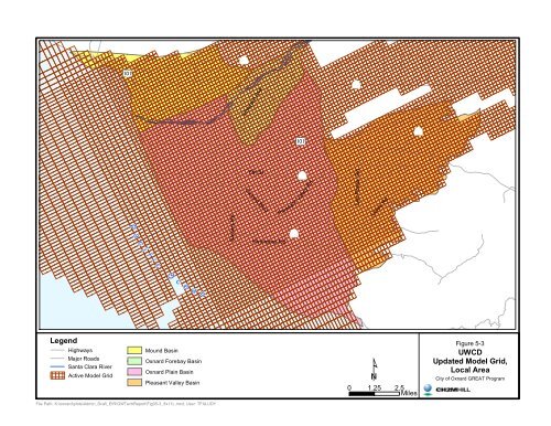
Vineyard AveaPc5th StOxnard BlvdHueneme RdSaviers RdPleasant Valley RdLas Posas RdLewis Rdi f icO ce a nLegendHighwaysMajor RoadsSanta Clara RiverActive Model GridMound BasinOxnard Forebay BasinOxnard Plain BasinPleasant Valley BasinFigure 5-3UWCDUpdated Model Grid,Local AreaCity of Oxnard GREAT Program0 1.25 2.5 MilesFile Path: K:\oxnard\plots\Admin_Draft_EIR\GWTechReport\Fig05-3_8x11L.mxd, User: TFALUDY
- Page 81 and 82: WATER RESOURCES TECHNICAL REPORTout
- Page 83 and 84: TABLE 3-2City Blended Water Quality
- Page 85 and 86: TABLE 3-4Agricultural Water Supply
- Page 87 and 88: Figure 3-1NNo ScaleOxnard Plain Wat
- Page 89 and 90: Figure 3-3Santa Clara RiverFlow and
- Page 91 and 92: Figure 3-5Agriculture andPumping al
- Page 93 and 94: Figure 3-7Agriculture and Pumpingal
- Page 95 and 96: 50,00045,00040,00035,000Supply and
- Page 97 and 98: Acre-Feet6,0005,0004,0003,0002,0001
- Page 99 and 100: WATER RESOURCES TECHNICAL REPORT4.1
- Page 101 and 102: WATER RESOURCES TECHNICAL REPORTSea
- Page 103 and 104: WATER RESOURCES TECHNICAL REPORTfro
- Page 105 and 106: WATER RESOURCES TECHNICAL REPORTcar
- Page 107 and 108: WATER RESOURCES TECHNICAL REPORTirr
- Page 109: WATER RESOURCES TECHNICAL REPORThyd
- Page 112 and 113: WATER RESOURCES TECHNICAL REPORT•
- Page 114 and 115: WATER RESOURCES TECHNICAL REPORTRec
- Page 116 and 117: WATER RESOURCES TECHNICAL REPORTdes
- Page 118 and 119: Hwy 101 - Ventura FwyCamarilloVentu
- Page 120 and 121: 101 FreewayVentura RoadCaminoDel So
- Page 122 and 123: WELL#21WELL#22WELL#20WELL #23BLENDI
- Page 124 and 125: 5.0 Historical Groundwater Flow Mod
- Page 126 and 127: WATER RESOURCES TECHNICAL REPORTcli
- Page 128 and 129: WATER RESOURCES TECHNICAL REPORT•
- Page 130 and 131: WATER RESOURCES TECHNICAL REPORT−
- Page 134 and 135: 6.0 GREAT Program Groundwater FlowM
- Page 136 and 137: WATER RESOURCES TECHNICAL REPORTgro
- Page 138 and 139: WATER RESOURCES TECHNICAL REPORTto
- Page 140 and 141: WATER RESOURCES TECHNICAL REPORTGro
- Page 142 and 143: WATER RESOURCES TECHNICAL REPORT6.1
- Page 144 and 145: WATER RESOURCES TECHNICAL REPORTfor
- Page 146 and 147: WATER RESOURCES TECHNICAL REPORTin
- Page 148 and 149: WATER RESOURCES TECHNICAL REPORT•
- Page 150 and 151: WATER RESOURCES TECHNICAL REPORT−
- Page 152 and 153: WATER RESOURCES TECHNICAL REPORTtwo
- Page 154 and 155: WATER RESOURCES TECHNICAL REPORTThe
- Page 156 and 157: TABLE 6-1Scenarios for Model Simula
- Page 158 and 159: 100Cumulative Departure from Mean20
- Page 160 and 161: 15060Elevation (feet, msl)00Rainfal
- Page 162 and 163: 5833aPci f ic5O c55185e a n51513552
- Page 164 and 165: -100406080700-40-20406050-103001402
- Page 166 and 167: 400-402030-50010-30-10-60-20-30-107
- Page 168 and 169: -20400-40103020-500-10-30-20-401200
- Page 170 and 171: 0-10-204030-40-50-30-1001020-20-40-
- Page 172 and 173: 0-204030-40-6001020-30-10-20-30-50-
- Page 174 and 175: North Oxnard Plain Area6 7 8 901N22
- Page 176 and 177: 10040608070504010901001201401701601
- Page 178 and 179: 14050809030506070104001030100120901
- Page 180 and 181: 10080507060401001201401701802001501
Vineyard AveaPc5th St<strong>Oxnard</strong> BlvdHueneme RdSaviers RdPleasant Valley RdLas Posas RdLewis Rdi f icO ce a nLegendHighwaysMajor RoadsSanta Clara RiverActive Model GridMound Basin<strong>Oxnard</strong> Forebay Basin<strong>Oxnard</strong> Plain BasinPleasant Valley BasinFigure 5-3UWCDUpdated Model Grid,Local Area<strong>City</strong> <strong>of</strong> <strong>Oxnard</strong> GREAT Program0 1.25 2.5 Miles<strong>File</strong> Path: K:\oxnard\plots\Admin_Draft_EIR\GWTechReport\Fig05-3_8x11L.mxd, User: TFALUDY


