

Uranium ore-forming systems of the - Geoscience Australia
Uranium ore-forming systems of the - Geoscience Australia
Uranium ore-forming systems of the - Geoscience Australia

Create successful ePaper yourself
Turn your PDF publications into a flip-book with our unique Google optimized e-Paper software.
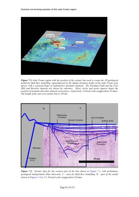
<strong>Uranium</strong> <strong>ore</strong>-<strong>forming</strong> <strong>systems</strong> <strong>of</strong> <strong>the</strong> Lake Frome regionFigure 7.1: Lake Frome region with <strong>the</strong> position <strong>of</strong> <strong>the</strong> seismic line used to create <strong>the</strong> 2D geologicalmodel for fluid flow modelling, superimposed on <strong>the</strong> digital elevation model <strong>of</strong> <strong>the</strong> Lake Frome area(grey), with a coloured drape <strong>of</strong> radiometrics (uranium channel). The Paralana Fault and <strong>the</strong> FourMile and Beverley deposits are shown for reference. Silver circles and green squares depict <strong>the</strong>position <strong>of</strong> uranium and o<strong>the</strong>r mineral occurrences, respectively. Vertical scale exaggeration 10 times.The length <strong>of</strong> <strong>the</strong> east-west seismic line is 130 km.BAWillawortinaFormationNamba FormationEyre FormationBulldog ShaleNeoproterozoicAdelaideanCadna-owieFormationMtPainterParalanaFLTZ25 kmFigure 7.2: Seismic data for <strong>the</strong> western part <strong>of</strong> <strong>the</strong> line shown in Figure 7.1, with preliminarygeological interpretation (blue linework). A – area for fluid flow modelling; B – part <strong>of</strong> <strong>the</strong> modelshown in Figures 7.4 to 7.8. Vertical scale exaggeration 10 times.Page 81 <strong>of</strong> 151


