Baden-Württemberg LIDAR Project - AARG 2010
Baden-Württemberg LIDAR Project - AARG 2010
Baden-Württemberg LIDAR Project - AARG 2010

You also want an ePaper? Increase the reach of your titles
YUMPU automatically turns print PDFs into web optimized ePapers that Google loves.
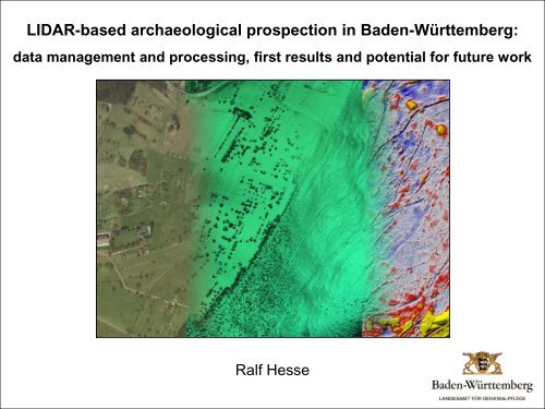
<strong>LIDAR</strong>-based archaeological prospection in <strong>Baden</strong>-<strong>Württemberg</strong>:data management and processing, first results and potential for future workRalf Hesse
IntroductionAims:• archaeological prospectionof <strong>Baden</strong>-<strong>Württemberg</strong>• verification and extension ofarchaeological site database
Introduction<strong>LIDAR</strong> data:• State Surveying Office• ~1 point/m 2• costs: annually 50 €/km 2(split among all users:several ministeries andsubsidiary institutions)<strong>Project</strong> details:• persons: 1• access to results: in-house
Challenge 1: data managementData amount• 35 751 km 2• raw data:>1 TB in ~160 000 filesFile sizes• combine files• max. ~0.5 GB• 25-100 km 2 per file• 400-1600 files per raster layer• 8-9 raster layers• up to 22 vector layers
Data management
Data management
Data management
Data management
Data management
Challenge 2: finding hills in the mountains• conventional hill shading• visibility depends on illumination
Finding hills in the mountains• optical illusion: relief inversion
Finding hills in the mountains• What is interesting, what isn't?+ small-scale surface structures+ small elevation differences (mostly ~0.1 to 1.0 m)- large-scale landscape forms440440Low pass filter1.6Difference map0 m0 m0 175 m70m0 175 m-3.70 175 m
Finding hills in the mountainsDifference map• adavantages/disadvantages• improvement1.6Extraction440Interpolation0 m440Difference map8.70 m-3.70 175 m70m0 175 m0 m0 175 m-8.60 175 m
Finding hills in the mountains8.7Local Relief ModelAdvantages:• local topographic anomalies0 m414 m 3135 m 3-8.60 175 m62 m 3• independent of illumination• morphometry applicationsDisadvantage:• computation
Supplementary data• data gaps and point density
First resultsSchönbuch• 600 km 2• 1966 known sites• 2513 <strong>LIDAR</strong> resultsSouthern Black Forest• 2750 km 2• 3760 known sites• 59337 <strong>LIDAR</strong> resultsResults• charcoal kiln sites• terraces, ridge and furrow• mining traces• sunken roads• (burial) mounds• earthworks
First resultsSouthern Black Forest: charcoal production
First resultsUpper Rhine area: fortifications
First resultsUpper Rhine area: mining traces
First resultsSchönbuch: ridge and furrow
First resultsSouthern Black Forest: burial moundsLuftbild (Google Luftbild Earth) (LAD) DGM LRM
First resultsGoldburghausenFoto: Marcus Meyer (LAD)Foto: Marcus Meyer (LAD)
First resultsUpper Rhine area: neolithic ring fort
Potential for future work• spatial / topographic analyses• application for predictive modelling