JeppView : LXGB (9 charts)
JeppView : LXGB (9 charts)
JeppView : LXGB (9 charts)

You also want an ePaper? Increase the reach of your titles
YUMPU automatically turns print PDFs into web optimized ePapers that Google loves.
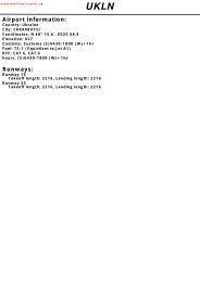
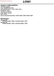
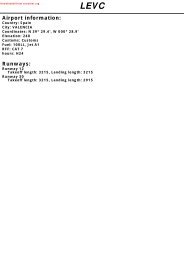
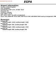
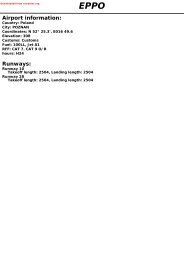
Downloaded from rutracker.orgAirport information:Country: GibraltarCity: GIBRALTARCoordinates: N 36° 09.2', W 005° 20.9'Elevation: 12Customs: CustomsFuel: F35RFF: CAT 7hours: CIVIL: 0800-2245LT<strong>LXGB</strong>Runways:Runway 09Takeoff length: 1680, Landing length: 1529Runway 27Takeoff length: 1630, Landing length: 1529
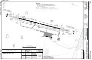
If you like to use this <strong>charts</strong>, please, buy a subscription for nDAC.For rutracker.orgAERODROMEGibraltar TWR RAD131.2 130.410 - 120 FEB 13Gibraltar - <strong>LXGB</strong> / GIBGIBRALTARAD Elev 12 ARP: N36 09.1 W005 21.0 RFF: CAT 4A, 5A ABVL O/R AD HR: 0800-2245, 24H PPR10 - 12WW005 21THR CoordinatesRWY 09 N36 09.1 W005 21.5RWY 27 N36 09.1 W005 20.4SpainR164FL300GibraltarTerminal09092°ELEV 1115830x150ft442m/ 1450ftMarina1529x46m5016x151ft105TWR117CHSACivilApronBGD457m/ 1499ftNorthApronE3141ELEV 1227272°N3609SouthApronRWY 09:Single yellow flashing light on yellow marker buoy1372m/ 4500ft from sea wall marks the extendedcentreline. Strobe lights angled to coincide with ACFTposition at 3nm switched off unless required by pilot.RWY 27:Single yellow flashing light on yellow marker buoy914m/ 3000ft from sea wall. Also single white flashinglights at 1829m/ 6000ft and 2743m/ 9000ft from seawall. Strobe lights, switched off when AFCT at 1nmunless required by pilot.470557DME GBR1 Black/yellow chequered areas0 500 1000m0 1000 2000 3000 4000ftNavtech - lxgb01laorg0RWY Slope TORA m/ ft LDA m/ ft ALS REDL Additional09 0 1680 / 5512 1529 / 5016 - H P 3° L/R (31)27 0 1630 / 5348 1529 / 5016 - H P 3° L/R (31)STATETAKE OFF MINIMARWYFacilities09/27 HREDLVISA B C D1.0 kmChange: RWY, TORA, LDA, Hot spot, RFFTHIS CHART IS A PART OF NAVIGRAPH CHARTS AND IS INTENDED FOR FLIGHT SIMULATION USE ONLY
If you like to use this <strong>charts</strong>, please, buy a subscription for nDAC.For rutracker.org20 FEB 13Gibraltar - <strong>LXGB</strong> / GIBAERODROME ParkingGIBRALTARGibraltar TWR RAD131.2 130.410 - 210 - 2TWRCSouthApronRWY 09/271 2 3 4 5CivilApronBAHSDTerminalNorthApronNavtech - lxgb02laorg0B1E11Black/yellow chequered areaChange: APN, Stands, Hot spotTHIS CHART IS A PART OF NAVIGRAPH CHARTS AND IS INTENDED FOR FLIGHT SIMULATION USE ONLY
If you like to use this <strong>charts</strong>, please, buy a subscription for nDAC.For rutracker.orgGENERAL10 - 4 20 FEB 13Gibraltar - <strong>LXGB</strong> / GIBGIBRALTAR10 - 4lxgb04gaorg07. EMERGENCY ARRIVAL PROCEDURES -MILITARY AIRCRAFTTACAN Let-down (for use in event ofSurveillance Radar Failure)7.1 Initial Approach.To be from the EAST on 105R at a safequadrantal Flight Level. The acft is to benot below FL70 at 10d and at 5000ft whenoverhead. From overhead the TACAN leftoubd on 105R. When established oubddescend to 2000QFE. At 10d commencea procedure turn left to re-establish inbdon 105R maintaining 2000 QFE until visualwith the Rock. If visual contact with theRock cannot be established by 2·5d climb to3900 QNH and turn left to intercept and fl y165R. Acft using 2 Navaids (eg TACAN andINS) need not overfly the facility and areauthorised to begin the oubd turn at 3d.8. WHEN ROCK OR RUNWAY IN SIGHT.8.1 Runway 09. Turn left to position for a righthandcircuit to land. The circuit is to be fl ownso as to ensure no violation of SpanishProhibited airspace.8.2 Runway 27. Continue with visual approachto land.9. TURNAROUND PROCEDUREMost large aircraft (eg. B757) can use upto 60m of the usable departure runwayduring the turnaround procedure afterbacktracking. Flight crews are to takeinto account any reduction of availabledeparture runway for their own aircraft,within their performance calculations.10. TURBULENCE10.1 When the wind direction is between 110°and 250° and speed in excess of 15kts,moderate to severe turbulence should beexpected during final stages of fl ight to thelee of the rock and along the RWY surface.This can make landing dangerous orimpossible. Turbulence can often be seenon the water and is shown on chart 10-5.SW winds in excess of 25kts can lead tothe formation of waterspouts in the APP toRWY 27.10.2 Pilots are to observe wind limitations forlanding as published by their appropriateOperating Authority. Where no suchlimitations are published, the following maybe used for guidance:Wind Direction (°M) Wind Speed (kt)(Steady or Gusting)110 30120 25130 20140 18150 17160 16170 15180 15190 15200 16210 17220 18230 20240 22250 25Note: Wind speeds in excess of the fi guresquoted are likely to cause severe turbulenceand/or wind shear on Final Approach.11. DEPARTURE MINIMUMThe mnm Met visibility for departure is 1km.12. APPROACH MINIMANeither PANS-OPS nor APATC-1conforming procedures or procedureminima are available. Use of the rwyis limited to visual approaches only.The applicable weather minima for allapproaches is: Visibility 5km or 5km in thedirection of the approach path, Cloudbase1000. Pilots not in visual contact with thethreshold at the 3nm Visual Descent Point(VDP) are to initiate a MISAP as directed byATC.© Navtech -THIS Change: CHART 10.1 IS A PART OF NAVIGRAPH CHARTS AND IS INTENDED FOR FLIGHT SIMULATION USE ONLY
If you like to use this <strong>charts</strong>, please, buy a subscription for nDAC.For rutracker.orgGENERAL10 - 5 18 MAY 11Gibraltar - <strong>LXGB</strong> / GIBGIBRALTARFIGURE 1WINDS FROM 110°M TO 170°MWINDS FROM 130°M TO 170°MBAY OFGIBRALTARLa LineaFrontierFenceAreas most affectedby turbulence10 - 5HangarsMAIN WINDDIRECTIONGibraltar1397FIGURE 2WINDS FROM 170°M TO 200°MWINDS FROM 170°M TO 200°MLa LineaAreas most affectedby turbulenceBAY OFGIBRALTARFrontierFenceWHOLE RUNWAY SUBJECTTO TURBULENCEMAIN WINDDIRECTIONHangarsGibraltar1397FIGURE 3WINDS FROM 200°M TO 250°MWINDS FROM 200°M TO 230°MLa LineaAreas most affectedby turbulencelxgb05gaorg0© Navtech -MAIN WINDDIRECTIONBAY OFGIBRALTARFrontierFenceHangarsGibraltar1397UP DRAUGHTDOWN DRAUGHTReverse side blankTHIS Change: CHART New IS A print. PART OF NAVIGRAPH CHARTS AND IS INTENDED FOR FLIGHT SIMULATION USE ONLY
If you like to use this <strong>charts</strong>, please, buy a subscription for nDAC.For rutracker.org40 - 2 22 AUG 12Gibraltar - <strong>LXGB</strong> / GIBARRIVAL RWY 27 RNAV By ATC ONLYGIBRALTARGibraltar APP RAD TWR122.8 130.4 131.2TA 6000 AD Elev 12BARPAN35 50.0W005 40.0271° 22Gibraltar113.6 GBRN36 08.6W005 20.6P21FL240 GNDUM985B28Navtech - lxgb02aaorg0Martin MAR D112.6 Malaga MGA D112.0 To RAKOR269°MAX.3600FL90MAX. 210kt089°XAVIRN36 00.2W005 14.6GALTON35 50.0W005 08.6ALPHAN36 00.0W005 00.0PIMOSN36 09.0W004 53.6Tetouan117.3 TTNGBRN35 35.7W005 19.5UB11B11214°17 034°245° 1923 065°UB11 / UN869215°B1123 035°R164AlegecirasFL300GND/MSLD56Estepona1000 MSLMadrid FIR LECMCasablanca FIR GMMMFL65UN864180°B4254 360°UN869 / UM985B11 / B28214°Overflight of the rock and harbour prohibited40 - 2FL8547 034°UM44550 049°FL90RNAV 1GNSS DME / DME68FL245FL65FL245FL245FL903600FL245FL245FL245Change: Completely revisedTHIS CHART IS A PART OF NAVIGRAPH CHARTS AND IS INTENDED FOR FLIGHT SIMULATION USE ONLY
NALSIf you like to use this <strong>charts</strong>, please, buy a subscription for nDAC.For rutracker.orgSRA RWY 09Gibraltar APP RAD TWR122.8 130.4 131.250 - 120 FEB 13Gibraltar - <strong>LXGB</strong> / GIBGIBRALTARSRA FAT 360° DTHR Elev 11 AD Elev 12 TL ATC TA 6000W005 30 630 W005 207835583332WR164FL300552X-RAY9203nm RAD Fix1557 13971420TACANR164FL300090°GibraltarCh83X GBR (113.6)N36105nmRAD FixR164FL3006nmRAD Fix1Avoid overflying harbour area.360°117.8VJFR124(VICTR)VICTORD9 GBRN36 00.0W005 24.010nm1353968225GBR 25315N360050 - 1D9 GBRVICTOR (VICTR)RAD Vector360°6nmRAD Fix5nmRAD FixX-RAY3nmRAD FixGBRClimb to 4000as directed by ATC.At1520920Navtech - lxgb01iaorg0lxgb01iaip00STATEnm 11ACFTABCD10 9920SRA(909)5.0kmC87 6 5 4C 1000ftNote: Circling NA3210LDA 1529x465016x151ftP 3° L/R (31)GChange: LDATHIS CHART IS A PART OF NAVIGRAPH CHARTS AND IS INTENDED FOR FLIGHT SIMULATION USE ONLY
NALSIf you like to use this <strong>charts</strong>, please, buy a subscription for nDAC.For rutracker.orgSRA RWY 27Gibraltar APP RAD TWR122.8 130.4 131.250 - 220 FEB 13Gibraltar - <strong>LXGB</strong> / GIBGIBRALTARSRAFAT 270° DTHR Elev 12 AD Elev 12 TL ATC TA 60001215W005 20 W005 102W540552R164FL300783180°R164FL300(YANKE)1TACANYANKEE557 1397Gibraltar92010nm5nmRAD Fix6nmRAD Fix1420Ch83X GBR (113.6) 3nm RAD Fix RAD Fix270°N3610R164FL3001Avoid overflying harbour area.50 - 210nm1353968225GBR 25315Climb to 4000as directed by ATC.GBRYANKEE(YANKE)3nm RAD Fix5nmRAD Fix9206nmRAD FixAt152010nmRAD FixRAD Vector270°Navtech - lxgb02iaip00STATEACFTABCD920SRA(908)5.0kmCC 1000ftNote: Circling NA0 1 2 3 4 5 6 7 8 9 10 11 12 13 nmLDA 1529x465016x151ftP 3° L/R (31)GChange: LDATHIS CHART IS A PART OF NAVIGRAPH CHARTS AND IS INTENDED FOR FLIGHT SIMULATION USE ONLY