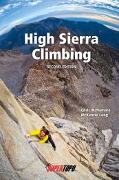
Yosemite Sport Climbs and Top Ropes - SuperTopo
Yosemite Sport Climbs and Top Ropes - SuperTopo
Yosemite Sport Climbs and Top Ropes - SuperTopo

You also want an ePaper? Increase the reach of your titles
YUMPU automatically turns print PDFs into web optimized ePapers that Google loves.
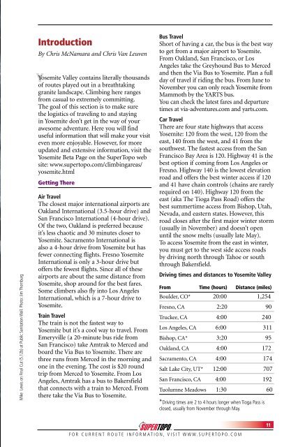
Mike Lewis on Final Cut (5.12b) at Public Sanitation Wall. Photo: Jim Thornburg<br />
Introduction<br />
By Chris McNamara <strong>and</strong> Chris Van Leuven<br />
Y<br />
<strong>Yosemite</strong> Valley contains literally thous<strong>and</strong>s<br />
of routes played out in a breathtaking<br />
granite l<strong>and</strong>scape. Climbing here ranges<br />
from casual to extremely committing.<br />
The goal of this section is to make sure<br />
the logistics of traveling to <strong>and</strong> staying<br />
in <strong>Yosemite</strong> don’t get in the way of your<br />
awesome adventure. Here you will find<br />
useful information that will make your visit<br />
even more enjoyable. However, for more<br />
updated <strong>and</strong> extensive information, visit the<br />
<strong>Yosemite</strong> Beta Page on the Super<strong>Top</strong>o web<br />
site: www.supertopo.com/climbingareas/<br />
yosemite.html<br />
Getting There<br />
Air Travel<br />
The closest major international airports are<br />
Oakl<strong>and</strong> International (3.5-hour drive) <strong>and</strong><br />
San Francisco International (4-hour drive).<br />
Of the two, Oakl<strong>and</strong> is preferred because<br />
it’s less chaotic <strong>and</strong> 30 minutes closer to<br />
<strong>Yosemite</strong>. Sacramento International is<br />
also a 4-hour drive from <strong>Yosemite</strong> but has<br />
fewer connecting flights. Fresno <strong>Yosemite</strong><br />
International is only a 3-hour drive but<br />
offers the fewest flights. Since all of these<br />
airports are about the same distance from<br />
<strong>Yosemite</strong>, shop around for the best fares.<br />
Some climbers also fly into Los Angeles<br />
International, which is a 7-hour drive to<br />
<strong>Yosemite</strong>.<br />
Train Travel<br />
The train is not the fastest way to<br />
<strong>Yosemite</strong> but it’s a cool way to travel. From<br />
Emeryville (a 20-minute bus ride from<br />
San Francisco) take Amtrak to Merced <strong>and</strong><br />
board the Via Bus to <strong>Yosemite</strong>. There are<br />
three runs from Merced in the morning <strong>and</strong><br />
one in the evening. The cost is $20 round<br />
trip from Merced to <strong>Yosemite</strong>. From Los<br />
Angeles, Amtrak has a bus to Bakersfield<br />
that connects with a train to Merced. From<br />
there take the Via Bus to <strong>Yosemite</strong>.<br />
Bus Travel<br />
Short of having a car, the bus is the best way<br />
to get from a major airport to <strong>Yosemite</strong>.<br />
From Oakl<strong>and</strong>, San Francisco, or Los<br />
Angeles take the Greyhound Bus to Merced<br />
<strong>and</strong> then the Via Bus to <strong>Yosemite</strong>. Plan a full<br />
day of travel if riding the bus. From June to<br />
November you can only reach <strong>Yosemite</strong> from<br />
Mammoth by the YARTS bus.<br />
You can check the latest fares <strong>and</strong> departure<br />
times at via-adventures.com <strong>and</strong> yarts.com.<br />
Car Travel<br />
There are four state highways that access<br />
<strong>Yosemite</strong>: 120 from the west, 120 from the<br />
east, 140 from the west, <strong>and</strong> 41 from the<br />
southwest. The fastest access from the San<br />
Francisco Bay Area is 120. Highway 41 is the<br />
best option if coming from Los Angeles or<br />
Fresno. Highway 140 is the lowest elevation<br />
road <strong>and</strong> offers the best winter access if 120<br />
<strong>and</strong> 41 have chain controls (chains are rarely<br />
required on 140). Highway 120 from the<br />
east (aka The Tioga Pass Road) offers the<br />
best summertime access from Bishop, Utah,<br />
Nevada, <strong>and</strong> eastern states. However, this<br />
road closes after the first major winter storm<br />
(usually in November) <strong>and</strong> doesn’t open<br />
until the snow melts (usually late May).<br />
To access <strong>Yosemite</strong> from the east in winter,<br />
you must get to the west side access roads<br />
by driving north through Tahoe or south<br />
through Bakersfield.<br />
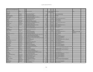
Driving times <strong>and</strong> distances to <strong>Yosemite</strong> Valley<br />
From Time (hours) Distance (miles)<br />
Boulder, CO* 20:00 1,254<br />
Fresno, CA 2:20 90<br />
Truckee, CA 4:00 240<br />
Los Angeles, CA 6:00 311<br />
Bishop, CA* 3:20 95<br />
Oakl<strong>and</strong>, CA 4:00 172<br />
Sacramento, CA 4:00 174<br />
Salt Lake City, UT* 12:00 707<br />
San Francisco, CA 4:00 192<br />
Tuolumne Meadows 1:30 60<br />
*Driving times are 2 to 4 hours longer when Tioga Pass is<br />
closed, usually from November through May.<br />
F O R C U R R E N T R O U T E I N F O R M A T I O N , V I S I T W W W . S U P E R T O P O . C O M<br />
11