Create successful ePaper yourself
Turn your PDF publications into a flip-book with our unique Google optimized e-Paper software.
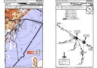
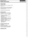
CHANGES: Transitions ANEXA 1B, VEBOS 1B established; MHA. | JEPPESEN SANDERSON, INC., 2005, 2007. ALL RIGHTS RESERVED.090^13600'2900'180^360^3800'12100'MSATPS VOR270^2200' within 15 NMANEXA1B, 1L163^ 14.4SOMOKBP424N47 37.4 E018 34.5NOT TO SCALEBP442N47 25.4 E018 30.5095^(IAF)(IAF)VEBOSBP4~~N47 18.4 E018 38.2ANEXAN47 51.3E018 29.2250 KT130^BP412N47 39.7E018 41.4210 KT6.6BP423N47 32.8 E018 41.6BP422N47 28.8 E018 48.2250 KTMHA FL1306.2 NMMAX FL190ANEXA 1BVEBOS 1B230 KT030^275^5.9BP418N47 36.5E018 46.7058^BP516N47 44.0E018 47.3At or above9000'040^130^6BP515N47 40.0E018 53.94.8 6 612.46 6VEBOS 1B512.9ANEXA1BVEBOS1B040^ANEXA1LVEBOS 1LTRANSITIONANEXA 1BANEXA 1LVEBOS 1BVEBOS 1L6BP419N47 32.5E018 53.2310^5BP514N47 35.9 E019 00.5040^At or above4000'2.6BP421N47 24.8 E018 54.83.41.5BP213N47 34.2 E019 03.4At or above3000'(FAF)BP42~N47 28.4 E018 59.8230 KTAfter receiving a 'DIRECT TO WAYPOINT'-clearance and reaching this point withouthaving received a follow-up clearance, thelast flown heading exceeding this waypointshall be continued.ROUTINGANEXA (K250) - SOMOK/BP424 - BP423 - BP422 (K230) - BP419 - BP418 -BP412 (K210) - BP516 (9000'+) - BP515 - BP514 (4000'+) - BP213 (3000'+) -BP513 (2500') - BP042.ANEXA (K250) - SOMOK/BP424 - BP423 - BP422 - BP421 - BP420 (K230) -BP419 - BP418 - BP412 (K210) - BP516 (9000'+) - BP515 - BP514 (4000'+) -BP213 (3000'+) - BP513 (2500') - BP042.VEBOS/BP400 (K250) - BP422 (K230) - BP419 - BP418 - BP412 (K210) - BP516(9000'+) - BP515 - BP514 (4000'+) - BP213 (3000'+) - BP513 (2500') - BP042.VEBOS/BP400 (K250) - BP421 - BP420 (K230) - BP419 - BP418 - BP412 (K210) -BP516 (9000'+) - BP515 - BP514 (4000'+) - BP213 (3000'+) - BP513 (2500') -BP042.BP513N47 31.9 E019 07.1At 2500'BP~42N47 30.9 E019 08.7TAPIOSAPD115.9 TPSN47 29.6 E019 26.8FROM WESTANEXA 1L [ANE1L]VEBOS 1B [VEB1B]VEBOS 1L [VEB1L]RWY 13L RNAV TRANSITIONSGPS/FMS-EQUIPPED AIRCRAFTGPS/FMS CLEARANCE PHRASEOLOGY1. "Cleared xxx Transition":Authorization to fly the lateral GPS/FMS-route.Altitude & speed assignments will be issued by ATC.2. "Cleared xxx Transition and Profile":Authorization to fly the GPS/FMS-route as published, includingthe vertical constraints depicted on the procedure.3. "Cleared direct Waypoint xxx":Authorization to fly from the present position to one or acombination of waypoints. Altitude & speed assignmentswill be issued by ATC.ANEXA 1B [ANE1B]ATIS117.3132.37Apt Elev495'Alt Set: hPa (MM on request) Trans level: By ATC Trans alt: 9000'1. On downwind expect vectors to final.2. Speed limits are mandatory from the respective waypoint throughoutthe entire transition route unless cancelled by ATC.<strong>LHBP</strong>/BUDFERIHEGY25 MAY 0710-2DJEPPESENBUDAPEST, HUNGARY.RNAV.TRANSITION.NOTICE: PRINTED FROM AN EXPIRED REVISION. Disc 01-2008Licensed to max. Printed on 16 Feb 2008.JEPPESENJeppView 3.5.2.0CHANGES: Transitions ANEXA 1J, VEBOS 1J established; MHA. | JEPPESEN SANDERSON, INC., 2005, 2007. ALL RIGHTS RESERVED.1090^3600'2900'180^360^3800'12100'MSATPS VOR2200' within 15 NMNOT TO SCALE(IAF)SOMOKBP424N47 37.4 E018 34.5BP442N47 25.4 E018 30.5095^270^ANEXAN47 51.3 E018 29.2250 KT163^ 14.4ANEXA 1J, 1R(IAF)VEBOSBP4~~N47 18.4 E018 38.2BP416N47 44.2 E018 45.1BP417N47 40.5 E018 40.1130^6.6BP423N47 32.8 E018 41.6BP422N47 28.8 E018 48.2250 KTMHA FL1306.2 NMMAX FL190210 KTANEXA 1JVEBOS 1J230 KT030^At or above9000'275^5040^BP418N47 36.5E018 46.7058^612.4130^6BP415N47 40.1E018 51.76 6VEBOS 1J12.95VEBOS 1RTRANSITIONANEXA 1JANEXA 1RVEBOS 1JVEBOS 1RBP414N47 36.1 E018 58.366 6ANEXA1JVEBOS1J040^ANEXA1RAt or above4000'BP419N47 32.5E018 53.2310^5ROUTINGANEXA (K250) - SOMOK/BP424 - BP423 - BP422 (K230) - BP419 - BP418 - BP417(K210) - BP416 (9000'+) - BP415 - BP414 (4000'+) - BP113 (3000'+) - BP413(2500') - BP049.ANEXA (K250) - SOMOK/BP424 - BP423 - BP422 - BP421 - BP420 (K230) - BP419 -BP418 - BP417 (K210) - BP416 (9000'+) - BP415 - BP414 (4000'+) - BP113(3000'+) - BP413 (2500') - BP049.VEBOS/BP400 (K250) - BP422 (K230) - BP419 - BP418 - BP417 (K210) - BP416(9000'+) - BP415 - BP414 (4000'+) - BP113 (3000'+) - BP413 (2500') - BP049.VEBOS/BP400 (K250) - BP421 - BP420 (K230) - BP419 - BP418 - BP417 (K210) -BP416 (9000'+) - BP415 - BP414 (4000'+) - BP113 (3000'+) - BP413 (2500') - BP049.040^4.3BP113N47 33.3E019 03.01.7 1.5BP421N47 24.8 E018 54.8At or above3000'(FAF)BP42~N47 28.4 E018 59.8230 KTGPS/FMS CLEARANCE PHRASEOLOGY1. "Cleared xxx Transition":Authorization to fly the lateral GPS/FMS-route.Altitude & speed assignments will be issued by ATC.2. "Cleared xxx Transition and Profile":Authorization to fly the GPS/FMS-route as published, includingthe vertical constraints depicted on the procedure.3. "Cleared direct Waypoint xxx":Authorization to fly from the present position to one or acombination of waypoints. Altitude & speed assignmentswill be issued by ATC.BP~49N47 31.1 E019 06.5BP413N47 32.1 E019 04.8At 2500'TAPIOSAPD115.9 TPSN47 29.6 E019 26.8After receiving a 'DIRECT TO WAYPOINT'-clearanceand reaching this point without having received a follow-upclearance, the last flown heading exceedingthis waypoint shall be continued.FROM WESTANEXA 1R [ANE1R]VEBOS 1J [VEB1J]VEBOS 1R [VEB1R]RWY 13R RNAV TRANSITIONSGPS/FMS-EQUIPPED AIRCRAFTANEXA 1J [ANE1J]ATIS117.3132.37Apt Elev495'Alt Set: hPa (MM on request) Trans level: By ATC Trans alt: 9000'1. On downwind expect vectors to final.2. Speed limits are mandatory from the respective waypoint throughoutthe entire transition route unless cancelled by ATC.<strong>LHBP</strong>/BUDFERIHEGY25 MAY 0710-2EJEPPESENBUDAPEST, HUNGARY.RNAV.TRANSITION.NOTICE: PRINTED FROM AN EXPIRED REVISION. Disc 01-2008Licensed to max. Printed on 16 Feb 2008.JEPPESENJeppView 3.5.2.0
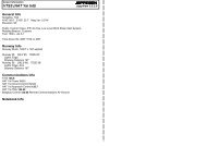
CHANGES: MHA. | JEPPESEN SANDERSON, INC., 2005, 2007. ALL RIGHTS RESERVED.(IAF)ANEXAN47 51.3 E018 29.2250 KTBP442N47 25.4 E018 30.5095^NOT TO SCALETRANSITIONANEXA 3LVEBOS 3L(IAF)VEBOSBP4~~N47 18.4 E018 38.2250 KT143^MHA FL1306.2 NMMAX FL19010.7130^MOKSABP441N47 42.1 E018 38.0275^040^ANEXA 3L16.2BP44~N47 31.1 E018 55.817.4VEBOS 3LGPS/FMS CLEARANCE PHRASEOLOGY1. "Cleared xxx Transition":Authorization to fly the lateral GPS/FMS-route.Altitude & speed assignments will be issued by ATC.2. "Cleared xxx Transition and Profile":Authorization to fly the GPS/FMS-route as published, includingthe vertical constraints depicted on the procedure.3. "Cleared direct Waypoint xxx":Authorization to fly from the present position to one or acombination of waypoints. Altitude & speed assignmentswill be issued by ATC.TAPIOSAPD115.9 TPSN47 29.6 E019 26.89.2BP439N47 24.9 E019 05.8After receiving a 'DIRECT TO WAYPOINT'-clearance and reaching this point withouthaving received a follow-up clearance, thelast flown heading exceeding this waypointshall be continued.BP438N47 16.8 E019 18.6ROUTINGANEXA (K250) - MOKSA/BP441 - BP440 - BP439 - BP438 (K230) -BP437 - BP436 - BP435 (K210) - BP434 (6000'+) - BP433 - BP432(3000'+) - BP431 (2500') - BP026.VEBOS/BP400 (K250) - BP440 - BP439 - BP438 (K230) - BP437 -BP436 - BP435 (K210) - BP434 (6000'+) - BP433 - BP432(3000'+) - BP431 (2500') - BP026.230 KT(FAF)BP026N47 21.5 E019 22.011.81.55BP437N47 13.5 E019 24.0BP431N47 20.5 E019 23.6At2500'55BP436N47 10.1 E019 29.4BP435N47 06.7 E019 34.8210 KTBP432N47 17.1 E019 29.0At or above3000'5 55BP433N47 13.7E019 34.4310^5040^090^3600'2900'180^360^3800'12100'MSATPS VOR1 2200' within 15 NMFROM WESTBP434N47 10.4E019 39.8270^ANEXA 3L [ANE3L]VEBOS 3L [VEB3L]RWY 31L RNAV TRANSITIONSGPS/FMS-EQUIPPED AIRCRAFTAt or above6000'ATIS117.3132.37Apt Elev495'Alt Set: hPa (MM on request) Trans level: By ATC Trans alt: 9000'1. On downwind expect vectors to final.2. Speed limits are mandatory from the respective waypoint throughoutthe entire transition route unless cancelled by ATC.<strong>LHBP</strong>/BUDFERIHEGY25 MAY 0710-2FJEPPESENBUDAPEST, HUNGARY.RNAV.TRANSITION.NOTICE: PRINTED FROM AN EXPIRED REVISION. Disc 01-2008Licensed to max. Printed on 16 Feb 2008.JEPPESENJeppView 3.5.2.0CHANGES: MHA. | JEPPESEN SANDERSON, INC., 2005, 2007. ALL RIGHTS RESERVED.(IAF)ANEXAN47 51.3 E018 29.2250 KTBP442N47 25.4 E018 30.5095^NOT TO SCALETRANSITIONANEXA 3RVEBOS 3R(IAF)VEBOSBP4~~N47 18.4 E018 38.2250 KT143^MHA FL1306.2 NMMAX FL19010.7130^MOKSABP441N47 42.1 E018 38.0275^040^ANEXA 3R16.2BP44~N47 31.1 E018 55.817.4VEBOS 3RGPS/FMS CLEARANCE PHRASEOLOGY1. "Cleared xxx Transition":Authorization to fly the lateral GPS/FMS-route.Altitude & speed assignments will be issued by ATC.2. "Cleared xxx Transition and Profile":Authorization to fly the GPS/FMS-route as published, includingthe vertical constraints depicted on the procedure.3. "Cleared direct Waypoint xxx":Authorization to fly from the present position to one or acombination of waypoints. Altitude & speed assignmentswill be issued by ATC.9.2BP439N47 24.9 E019 05.8After receiving a 'DIRECT TO WAYPOINT'-clearance and reaching this point withouthaving received a follow-up clearance, thelast flown heading exceeding this waypointshall be continued.DBP438N47 16.8 E019 18.6ROUTINGANEXA (K250) - MOKSA/BP441 - BP440 - BP439 - BP438 (K230) -BP437 - BP436 - BP430 (K210) - BP534 (7000'+) - BP533 - BP532(3000'+) - BP531 (2500') - BP035.VEBOS/BP400 (K250) - BP440 - BP439 - BP438 (K230) - BP437 -BP436 - BP430 (K210) - BP534 (7000'+) - BP533 - BP532(3000'+) - BP531 (2500') - BP035.TPSTAPIOSAP115.9 TPSN47 29.6 E019 26.811.8230 KT5(FAF)BP~35N47 20.9 E019 24.8BP437N47 13.5 E019 24.01.5BP436N47 10.1 E019 29.4BP43~N47 05.5 E019 36.8BP531N47 19.9 E019 26.45At5210 KT2500'BP532N47 16.5 E019 31.8At or above3000'BP533N47 13.2E019 37.26.85 5310^5.9040^090^3600'2900'180^360^BP534N47 09.8E019 42.63800'1270^2100'MSATPS VOR1 2200' within 15 NMFROM WESTRWY 31R RNAV TRANSITIONSGPS/FMS-EQUIPPED AIRCRAFTANEXA 3R [ANE3R]VEBOS 3R [VEB3R]At or above7000'ATIS117.3132.37Apt Elev495'Alt Set: hPa (MM on request) Trans level: By ATC Trans alt: 9000'1. On downwind expect vectors to final.2. Speed limits are mandatory from the respective waypoint throughoutthe entire transition route unless cancelled by ATC.<strong>LHBP</strong>/BUDFERIHEGY25 MAY 07JEPPESEN10-2GBUDAPEST, HUNGARY.RNAV.TRANSITION.NOTICE: PRINTED FROM AN EXPIRED REVISION. Disc 01-2008Licensed to max. Printed on 16 Feb 2008.JEPPESENJeppView 3.5.2.0
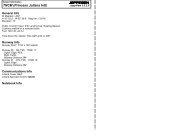
Licensed to max. Printed on 16 Feb 2008.NOTICE: PRINTED FROM AN EXPIRED REVISION. Disc 01-2008<strong>LHBP</strong>/BUDFERIHEGYATIS117.3132.37Apt Elev495'29 JUL 05JEPPESEN10-2H.Eff.4.Aug.JEPPESENJeppView 3.5.2.0BUDAPEST, HUNGARY.RNAV.TRANSITION.Alt Set: hPa (MM on request) Trans level: By ATC Trans alt: 9000'1. On downwind expect vectors to final. 2. Speed limits are mandatoryfrom the respective waypoint throughout the entire transition route unlesscancelled by ATC.Licensed to max. Printed on 16 Feb 2008.NOTICE: PRINTED FROM AN EXPIRED REVISION. Disc 01-2008<strong>LHBP</strong>/BUDFERIHEGYATIS117.3132.37Apt Elev495'29 JUL 05JEPPESEN10-2J.Eff.4.Aug.JEPPESENJeppView 3.5.2.0BUDAPEST, HUNGARY.RNAV.TRANSITION.Alt Set: hPa (MM on request) Trans level: By ATC Trans alt: 9000'1. On downwind expect vectors to final. 2. Speed limits are mandatoryfrom the respective waypoint throughout the entire transition route unlesscancelled by ATC.RUTOL 1L [RUT1L]RWY 13L RNAV TRANSITIONGPS/FMS-EQUIPPED AIRCRAFTFROM NORTHWEST090^3600'2900'180^360^3800'1270^2100'RUTOL 1R [RUT1R]RWY 13R RNAV TRANSITIONGPS/FMS-EQUIPPED AIRCRAFTFROM NORTHWEST090^3600'2900'180^360^3800'1270^2100'(IAWP)RUTOLN47 57.5 E018 30.6250 KTMSATPS VOR1 2200' within 15 NM(IAWP)RUTOLN47 57.5 E018 30.6250 KT1MSATPS VOR2200' within 15 NM106^BP517N47 47.6 E018 52.4BP516N47 44.0 E018 47.3At or above9000'210 KT18.95130^BP515N47 40.0 E018 53.9BP514N47 35.9 E019 00.5BP213N47 34.2 E019 03.4BP523N47 51.5 E018 57.36666 6 2.6 3.4 1.5220^At or above4000'130^At or above3000'GPS/FMS CLEARANCE PHRASEOLOGY1. "Cleared xxx Transition":Authorization to fly the lateral GPS/FMS-route. Altitude & speed assignmentswill be issued by ATC.2. "Cleared xxx Transition and Profile":Authorization to fly the GPS/FMS-routeas published, including the verticalconstraints depicted on the procedure.3. "Cleared direct Waypoint xxx":Authorization to fly from the presentposition to one or a combination ofwaypoints. Altitude & speed assignmentswill be issued by ATC.CHANGES: New chart.BP518N47 43.6E018 59.0BP513N47 31.9 E019 07.1At2500'6.2 NMMHA 7000MAX FL190MAMOSBP600N47 47.3E019 04.06.2 6 6BP519N47 39.6E019 05.5310^BP522N47 43.2 E019 10.6(FAWP)5220^BP042N47 30.9 E019 08.7NOT TO SCALEBP521N47 39.2 E019 17.1BP520N47 35.6 E019 12.1230 KTAfter receiving a 'DIRECT TOWAYPOINT'-clearance andreaching this point withouthaving received a follow-upclearance, the last flownheading exceeding thiswaypoint shall be continued.ROUTINGRUTOL (K250) - BP523 - MAMOS/BP600 - BP521 - BP520 (K230) - BP517 (K210) - BP516(9000'+) - BP514 (4000'+) - BP213 (3000'+) - BP513 (2500') - BP042.310^TAPIOSAPD115.9 TPSN47 29.6 E019 26.8| JEPPESEN SANDERSON, INC., 2005. ALL RIGHTS RESERVED.106^BP512N47 48.5 E018 51.1BP416N47 44.2E018 45.1At or above9000'210 KT18.9BP415N47 40.1 E018 51.7BP414N47 36.1 E018 58.3BP523N47 51.5 E018 57.37.266130^6 6 4.3 1.71.55.9220^At or above4000'130^BP113N47 33.3 E019 03.0At or above3000'BP518N47 43.6E018 59.0BP413N47 32.1 E019 04.8GPS/FMS CLEARANCE PHRASEOLOGY1. "Cleared xxx Transition":Authorization to fly the lateral GPS/FMS-route. Altitude & speed assignmentswill be issued by ATC.2. "Cleared xxx Transition and Profile":Authorization to fly the GPS/FMS-routeas published, including the verticalconstraints depicted on the procedure.3. "Cleared direct Waypoint xxx":Authorization to fly from the presentposition to one or a combination ofwaypoints. Altitude & speed assignmentswill be issued by ATC.CHANGES: New chart.At2500'6.2 NMMHA 7000MAX FL190MAMOSBP600N47 47.3E019 04.06.2 6 6BP519N47 39.6E019 05.5310^(FAWP)BP522N47 43.2 E019 10.65220^BP049N47 31.1 E019 06.5NOT TO SCALEBP521N47 39.2 E019 17.1BP520N47 35.6 E019 12.1230 KTAfter receiving a 'DIRECT TOWAYPOINT'-clearance andreaching this point withouthaving received a follow-upclearance, the last flownheading exceeding thiswaypoint shall be continued.ROUTINGRUTOL (K250) - BP523 - MAMOS/BP600 - BP521 - BP520 (K230) - BP512 (K210) - BP416(9000'+) - BP414 (4000'+) - BP113 (3000'+) - BP413 (2500') - BP049.310^TAPIOSAPD115.9 TPSN47 29.6 E019 26.8| JEPPESEN SANDERSON, INC., 2005. ALL RIGHTS RESERVED.
Licensed to max. Printed on 16 Feb 2008.NOTICE: PRINTED FROM AN EXPIRED REVISION. Disc 01-2008<strong>LHBP</strong>/BUDFERIHEGYATIS117.3132.3712.7132^(IAWP)Apt Elev495'RUTOLN47 57.5 E018 30.6250 KTERGOMBP020N47 48.5E018 44.0114^JEPPESENJeppView 3.5.2.0BUDAPEST, HUNGARY.RNAV.TRANSITION.Alt Set: hPa (MM on request) Trans level: By ATC Trans alt: 9000'1. On downwind expect vectors to final. 2. Speed limits are mandatoryfrom the respective waypoint throughout the entire transition route unlesscancelled by ATC.20.929 JUL 0510-2KMAMOSBP600N47 47.3 E019 04.0JEPPESEN.Eff.4.Aug.RUTOL 3L [RUT3L]RWY 31L RNAV TRANSITION6.2 NMMHA 7000MAX FL190130^GPS/FMS-EQUIPPED AIRCRAFTFROM NORTHWEST310^GPS/FMS CLEARANCE PHRASEOLOGY1. "Cleared xxx Transition":Authorization to fly the lateral GPS/FMS-route. Altitude & speed assignmentswill be issued by ATC.2. "Cleared xxx Transition and Profile":Authorization to fly the GPS/FMS-routeas published, including the verticalconstraints depicted on the procedure.3. "Cleared direct Waypoint xxx":Authorization to fly from the presentposition to one or a combination ofwaypoints. Altitude & speed assignmentswill be issued by ATC.1090^3600'2900'180^360^3800'12100'MSATPS VOR270^2200' within 15 NMLicensed to max. Printed on 16 Feb 2008.NOTICE: PRINTED FROM AN EXPIRED REVISION. Disc 01-2008<strong>LHBP</strong>/BUDFERIHEGYATIS117.3132.3712.7132^(IAWP)RUTOLN47 57.5 E018 30.6250 KTERGOMBP020N47 48.5E018 44.0Apt Elev495'114^JEPPESENJeppView 3.5.2.0BUDAPEST, HUNGARY.RNAV.TRANSITION.Alt Set: hPa (MM on request) Trans level: By ATC Trans alt: 9000'1. On downwind expect vectors to final. 2. Speed limits are mandatoryfrom the respective waypoint throughout the entire transition route unlesscancelled by ATC.20.929 JUL 05MAMOSBP600N47 47.3 E019 04.0JEPPESEN10-2L.Eff.4.Aug.RUTOL 3R [RUT3R]RWY 31R RNAV TRANSITION6.2 NMMHA 7000MAX FL190130^GPS/FMS-EQUIPPED AIRCRAFTFROM NORTHWEST310^090^3600'2900'180^360^3800'GPS/FMS CLEARANCE PHRASEOLOGY1. "Cleared xxx Transition":Authorization to fly the lateral GPS/FMS-route. Altitude & speed assignmentswill be issued by ATC.2. "Cleared xxx Transition and Profile":Authorization to fly the GPS/FMS-routeas published, including the verticalconstraints depicted on the procedure.3. "Cleared direct Waypoint xxx":Authorization to fly from the presentposition to one or a combination ofwaypoints. Altitude & speed assignmentswill be issued by ATC.1MSATPS VOR270^2100'1 2200' within 15 NMBP540N47 39.1 E019 11.7130^ R310^13.9160^5000D115.9 TPSTAPIOSAPN47 29.6 E019 26.8BP002N47 29.6 E019 26.8BP540N47 39.1 E019 11.7130^ R310^13.9160^5000DTPSTAPIOSAP115.9 TPSN47 29.6 E019 26.8BP002N47 29.6 E019 26.8340^340^150^6.8BP538N47 23.6 E019 31.4230 KTNOT TO SCALE150^6.8BP538N47 23.6 E019 31.4230 KTNOT TO SCALEAfter receiving a 'DIRECT TOWAYPOINT'-clearance andreaching this point withouthaving received a follow-upclearance, the last flownheading exceeding thiswaypoint shall be continued.(FAWP)BP026N47 21.5 E019 22.01.5130^BP433N47 13.7 E019 34.4BP434N47 10.4 E019 39.85 5 3.2BP537N47 20.2 E019 36.9BP431N47 20.5 E019 23.6BP536At 2500'BP530 N47 16.8N47 14.6 E019 42.3BP432E019 45.7N47 17.1 E019 29.0210 KTAt or above3000'55At or above6000'5310^5.9220^BP535N47 13.4 E019 47.6210 KT 2After receiving a 'DIRECT TOWAYPOINT'-clearance andreaching this point withouthaving received a follow-upclearance, the last flownheading exceeding thiswaypoint shall be continued.(FAWP)BP035N47 20.9 E019 24.8BP531N47 19.9 E019 26.4At2500'BP532N47 16.5 E019 31.8At or above3000'1.5130^5 5BP533N47 13.2 E019 37.25 5BP534N47 09.8 E019 42.6At or above7000'BP537N47 20.2 E019 36.95310^2BP536N47 16.8E019 42.355220^ROUTINGRUTOL (K250) - ERGOM/BP020 - BP540 - TPS/BP002 - BP538 (K230) - BP530 (K210) - BP434(6000'+) - BP432 (3000'+) - BP431 (2500') - BP026.CHANGES: New chart.| JEPPESEN SANDERSON, INC., 2005. ALL RIGHTS RESERVED.ROUTINGRUTOL (K250) - ERGOM/BP020 - BP540 - TPS/BP002 - BP538 (K230) - BP535 (K210) - BP534(7000'+) - BP532 (3000'+) - BP531 (2500') - BP035.CHANGES: New chart.| JEPPESEN SANDERSON, INC., 2005. ALL RIGHTS RESERVED.
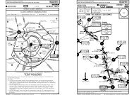
178Licensed to max. Printed on 16 Feb 2008.NOTICE: PRINTED FROM AN EXPIRED REVISION. Disc 01-2008<strong>LHBP</strong>/BUD25 MAY 07 10-3FERIHEGYBUDAPESTApproach (R)129.7Apt Elev495'BADOVBP11~N48 01.3 E018 49.0BUDAPEST117.3 BUDD(T)N47 27.0 E019 15.0010^017^035^053^JEPPESENJeppView 3.5.2.0BUDAPEST, HUNGARYTrans level: By ATC Trans alt: 9000'1. If not otherwise instructed by Tower contact BUDAPEST Approachwhen passing 1500'.2. SIDs include minimum noise routings. Strict adherence to prescribedtracks is mandatory for safety reasons and noise abatement.3. An acceleration segment according to PANS-OPS is not contained.BADOV 1D [BADO1D]LITKU 1D [LITK1D]RWYS 13L/R DEPARTURESAt or belowFL180CHANGES: None.11TO NORTHSPEED: MAX 250 KT BELOW FL100293^BP719N47 56.3 E019 04.0TAPIOSAPD115.9 TPSN47 29.6 E019 26.86BP613N47 22.0 E019 21.2BP713N47 22.6E019 22.14BUD 6.6 DME1920020^.SID.11 2200' within 15 NMD18.9 BUDD21.8 BUDBP718BP716N47 45.5 E019 21.3 N47 44.2 E019 34.9At or above8000'BUD 30 DMEThese SIDs require a minimum climb gradientof334' per NM (5.5%) up to 7000'.SIDBADOV 1DLITKU 1DInitial climb clearance 7000'16JEPPESENLITKUBP~94N48 13.8E019 35.9BetweenFL140 &FL180D36 BUDBP717N48 00.9 E019 33.2BADOV 1D1313310^005^LITKU 1D353^3600'090^2900'180^360^At or above8000'D17 BUDBP715N47 36.6 E019 35.7At or above6000'3800'2100'Gnd speed-KT 75 100 150 200 250 300334' per NM 418 557 835 1114 1392 1671If unable to comply advise ATC.further climb by ATCNOT TO SCALEMSATPS VORINITIAL CLIMB/ROUTINGOn runway heading to BUD 6.6 DME, turn LEFT, 020^ track, at D17 BUD turnLEFT, 310^ track, at BUD 30 DME turn LEFT, 293^ track to BADOV.GPS/FMS: BP613 (13R)/BP713 (13L) - BP715 (6000'+) - BP718 (8000'+) -BP719 - BADOV/BP110 (FL180-).On runway heading to BUD 6.6 DME, turn LEFT, 020^ track, at D17 BUD turnLEFT, 353^ track, at D36 BUD turn RIGHT, 005^ track to LITKU.GPS/FMS: BP613 (13R)/BP713 (13L) - BP715 (6000'+) - BP716 (8000'+) -BP717 - LITKU/BP094 (FL140+; FL180-).270^| JEPPESEN SANDERSON, INC., 2004, 2006. ALL RIGHTS RESERVED.Licensed to max. Printed on 16 Feb 2008.NOTICE: PRINTED FROM AN EXPIRED REVISION. Disc 01-2008<strong>LHBP</strong>/BUDFERIHEGYBUDAPESTApproach (R)129.7BADOV 3D [BADO3D]LITKU 3D [LITK3D]LITKU 3X [LITK3X]RWY 31L DEPARTURESBADOV 3DBP637N47 47.3E018 54.4Apt Elev495'TO NORTH15BUD 24.6 DME343^8BUD 17 DMEAt or belowFL180055^BADOV 3DLITKU 3XBUDAPEST343 A AN47 27.3 E019 12.6BP636N47 39.2 E018 57.51410-3ABP~52N47 29.0E019 10.7316^LITKUBP~94N48 13.8 E019 35.928LITKU 3XAt orabove2000'8018^2BUD 19.2 DME320^1BUDAPEST117.3 BUDD(T)N47 27.0 E019 15.0JEPPESENJeppView 3.5.2.0BUDAPEST, HUNGARYTrans level: By ATC Trans alt: 9000'1. If not otherwise instructed by Tower contact BUDAPEST Approachwhen passing 1500'.2. SIDs include minimum noise routings. Strict adherence to prescribedtracks is mandatory for safety reasons and noise abatement.3. An acceleration segment according to PANS-OPS is not contained.Turn RIGHT notbefore Aor below 950'BUD3.5 DME.SID.Gnd speed-KT 75 100 150 200 250 300334' per NM 418 557 835 1114 1392 1671These SIDs require a minimum climb gradientofIf unable to comply advise ATC.334' per NM (5.5%) up to 7000'.Initial climb clearance 7000', further climb by ATCRWYINITIAL CLIMB31L FIRST SEGMENT: Climb to A with take-off power/thrust, take-off flaps, V 2 +10 KT to20 KT (or as limited by body angle).SECOND SEGMENT: After passing A turn RIGHT (do not turn before A or below 950'),320^ track to BUD 3.5 DME, maintain a positive rate of climb, accelerate to zero flapminimum safe manoeuvring speed (V ZF ) retracting flaps on schedule, thereafter reducethrust to not less than climb power and continue climb at not greater than V ZF +10 KTto 20 KT.THIRD SEGMENT: At 3500' accelerate smoothly to en-route climb speed.Pilots have to apply minimum noise take-off technique for their aircraft type, if it isnot consistent with the procedures above.SIDROUTINGBADOV 3D At BUD 3.5 DME on 316^ track, at BUD 17 DME turn RIGHT, 343^ track to BADOV.GPS/FMS: BP052 (2000'+) - BP636 - BADOV/BP110 (FL180-).LITKU 3D At BUD 3.5 DME turn RIGHT, 018^ track to LITKU.GPS/FMS: BP052 (2000'+) - BP638 (3500'+) - BP629 (8000'+) - BP639 - LITKU/BP094 (FL140+; FL180-).LITKU 3X At BUD 3.5 DME on 316^ track, at BUD 17 DME turn RIGHT, 343^ track, at BUD24.6 DME turn RIGHT, 055^ track, at BUD 36.2 DME turn LEFT, 018^ track to LITKU.GPS/FMS: BP052 (2000'+) - BP636 - BP637 - BP639 - LITKU/BP094 (FL140+;FL180-).CHANGES: Initial climb.25 MAY 07SPEED: MAX 250 KT BELOW FL100BADOVBP11~N48 01.3 E018 49.0JEPPESENLITKU3DBetweenFL140 &FL180BUD 36.2 DME10 17BUD 9.8 DME131BP639MSAN48 01.9E019 29.1 TPS VOR1 2200' within 15 NMBP629N47 45.9 E019 20.1At or above8000'BP638N47 36.9 E019 15.1At or above3500'3600'090^2900'180^360^3800'2100'NOT TO SCALE270^TAPIOSAPD115.9 TPSN47 29.6 E019 26.8| JEPPESEN SANDERSON, INC., 2004, 2007. ALL RIGHTS RESERVED.
178Licensed to max. Printed on 16 Feb 2008.NOTICE: PRINTED FROM AN EXPIRED REVISION. Disc 01-2008<strong>LHBP</strong>/BUDFERIHEGYBUDAPESTApproach (R)129.7SPEED:BADOV 3D [BADO3D]LITKU 3D [LITK3D]LITKU 3X [LITK3X]RWY 31R DEPARTURESBP637N47 47.3E018 54.4Apt Elev495'BP636N47 39.2 E018 57.5TO NORTHMAX 250 KT BELOW FL100BADOVBP11~N48 01.3 E018 49.0BADOV 3D15BUD 24.6 DME343^8At or belowFL180055^BADOV 3DLITKU 3XBP~52N47 29.0 E019 10.7At or above2000'BUD 17 DME14316^018^10-3BBP638N47 36.9 E019 15.18JEPPESENJeppView 3.5.2.0BUDAPEST, HUNGARYTrans level: By ATC Trans alt: 9000'1. If not otherwise instructed by Tower contact BUDAPEST Approachwhen passing 1500'.2. SIDs include minimum noise routings. Strict adherence to prescribedtracks is mandatory for safety reasons and noise abatement.3. An acceleration segment according to PANS-OPS is not contained..SID.BPR 2.3 DMETAPIOSAPD115.9 TPSThese SIDs require a minimum climbBPRgradient ofN47 29.6 E019 26.81.5 DME334' per NM (5.5%) up to 7000'.ILS DMEGnd speed-KT 75 100 150 200 250 300DFERIHEGY334' per NM 418 557 835 1114 1392 1671 BPR (109.5) 2If unable to comply advise ATC.N47 25.4 E019 17.4Initial climb clearance 7000', further climb by ATCRWYINITIAL CLIMB31R FIRST SEGMENT: Climb to 1000' with take-off power/thrust, take-off flaps,V 2 + 10 KT to 20 KT (or as limited by body angle).SECOND SEGMENT: At 1000' turn LEFT (do not turn before BPR 1.5 DME and not laterthan BPR 2.3 DME) to A, turn RIGHT, 320^ track to BUD 3.5 DME, maintain a positiverate of climb, accelerate to zero flap minimum safe manoeuvring speed (V ZF) retractingflaps on schedule, thereafter reduce thrust to not less than climb power and continueclimb at not greater than V ZF +10 KT to 20 KT.THIRD SEGMENT: At 3500' accelerate smoothly to en-route climb speed.Pilots have to apply minimum noise take-off technique for their aircraft type, if it isnot consistent with the procedures above.SIDROUTINGBADOV 3D At BUD 3.5 DME on 316^ track, at BUD 17 DME turn RIGHT, 343^ track to BADOV.GPS/FMS: BP052 (2000'+) - BP636 - BADOV/BP110 (FL180-).LITKU 3D At BUD 3.5 DME turn RIGHT, 018^ track to LITKU.GPS/FMS: BP052 (2000'+) - BP638 (3500'+) - BP629 (8000'+) - BP639 - LITKU/BP094 (FL140+; FL180-).LITKU 3X At BUD 3.5 DME on 316^ track, at BUD 17 DME turn RIGHT, 343^ track, at BUD24.6 DME turn RIGHT, 055^ track, at BUD 36.2 DME turn LEFT, 018^ track to LITKU.GPS/FMS: BP052 (2000'+) - BP636 - BP637 - BP639 - LITKU/BP094 (FL140+;FL180-).CHANGES: Initial climb.25 MAY 07JEPPESEN2320^LITKUBP~94N48 13.8 E019 35.928LITKU 3XAt or above3500'BUD 9.8 DMEBetweenFL140 &FL180BUD 36.2 DMEBUD 19.2 DMEBUDLITKU 3D3.5 DME210 1713BUDAPESTA1BP639N48 01.9 MSAE019 29.1 TPS VOR1 2200' within 15 NMBP629N47 45.9 E019 20.1117.3 BUDAt or above8000'D(T)N47 27.0 E019 15.0Turn at 1000'but not beforeBPR 1.5 DMEand not later thanBPR 2.3 DME3600'090^2900'180^360^2BUDAPEST343 A3800'2100'N47 27.3 E019 12.6At or above1500'TPS270^NOT TO SCALE| JEPPESEN SANDERSON, INC., 2004, 2007. ALL RIGHTS RESERVED.Licensed to max. Printed on 16 Feb 2008.NOTICE: PRINTED FROM AN EXPIRED REVISION. Disc 01-2008<strong>LHBP</strong>/BUDFERIHEGYBUDAPESTApproach (R)129.7NOT TO SCALEBUDAPEST117.3 BUDApt Elev495'D(T)N47 27.0 E019 15.0SIDNALAG 1DNORAH 1DNALAG 1D [NALA1D]NORAH 1D [NORA1D]RWYS 13L/R DEPARTURESBP613N47 22.0 E019 21.2TAPIOSAPD115.9 TPSN47 29.6 E019 26.86BP713N47 22.6E019 22.1CHANGES: SID NALAG 1D established.4BUD 6.6 DME1920020^017^035^10-3C053^085^NALAGBP~22N48 02.6 E019 46.09D17 BUDBP715N47 36.6 E019 35.7JEPPESENJeppView 3.5.2.0BUDAPEST, HUNGARYTrans level: By ATC Trans alt: 9000'1. If not otherwise instructed by Tower contact BUDAPEST Approachwhen passing 1500'.2. SIDs include minimum noise routings. Strict adherence to prescribedtracks is mandatory for safety reasons and noise abatement.3. An acceleration segment according to PANS-OPS is not contained.TO NORTHEAST & EASTSPEED: MAX 250 KT BELOW FL100D36 BUDBP717N48 00.9 E019 33.2D21.8 BUDBP716N47 44.2 E019 34.9At or above8000'25 MAY 07JEPPESENNALAG 1D076^Initial climb clearance 7000'353^9At or above6000'At or belowFL170NORAH 1D3600'090^2900'.SID.11 2200' within 15 NMNORAHBP~13N47 37.0 E019 48.5At or belowFL130INITIAL CLIMB/ROUTINGOn runway heading to BUD 6.6 DME, turn LEFT, 020^ track, at D17 BUD turnLEFT, 353^ track, at D36 BUD turn RIGHT, 076^ track to NALAG.GPS/FMS: BP613 (13R)/BP713 (13L) - BP715 (6000'+) - BP716 (8000+) -BP717 - NALAG/BP022 (FL170-).On runway heading to BUD 6.6 DME, turn LEFT, 020^ track, at D17 BUD turnRIGHT, 085^ track to NORAH.GPS/FMS: BP613 (13R)/BP713 (13L) - BP715 (6000'+) - NORAH/BP013(FL130-).180^360^3800'2100'MSATPS VOR270^These SIDs require a minimum climb gradientof334' per NM (5.5%) up to 7000'.Gnd speed-KT 75 100 150 200 250 300334' per NM 418 557 835 1114 1392 1671If unable to comply advise ATC.further climb by ATC| JEPPESEN SANDERSON, INC., 2004, 2007. ALL RIGHTS RESERVED.
Licensed to max. Printed on 16 Feb 2008.NOTICE: PRINTED FROM AN EXPIRED REVISION. Disc 01-2008<strong>LHBP</strong>/BUDFERIHEGYBUDAPESTApproach (R)129.7Apt Elev495'NALAG 3D [NALA3D]NALAG 3X [NALA3X]NORAH 3D [NORA3D]RWY 31L DEPARTURESBP637N47 47.3E018 54.4BUD 24.6 DME343^TO NORTHEAST & EAST8BUD 17 DME055^BP636N47 39.2E018 57.5BUDAPEST343 A AN47 27.3 E019 12.6Turn RIGHT notbefore Aor below 950'NALAG 3X10⁻³D087^JEPPESENJeppView 3.5.2.0BUDAPEST, HUNGARYTrans level: By ATC Trans alt: 9000'1. If not otherwise instructed by Tower contact BUDAPEST Approachwhen passing 1500'.2. SIDs include minimum noise routings. Strict adherence to prescribedtracks is mandatory for safety reasons and noise abatement.3. An acceleration segment according to PANS-OPS is not contained.14BP638N47 36.9 E019 15.1BP~52N47 29.0E019 10.7316^BUD3.5 DME25 MAY 07SPEED: MAX 250 KT BELOW FL10028At or above3500'At orabove2000'8018^2320^1BUD 36.2 DME10 17NALAG 3DBUD 9.8 DMEBP639N48 01.9E019 29.1BUD 19.2 DMEBUDAPEST117.3 BUDD(T)N47 27.0 E019 15.0084^11NALAGBP~22N48 02.6 E019 46.0At or belowFL170BP629N47 45.9 E019 20.1At or above8000'23NORAH 3D.SID.11 2200' within 15 NMNORAHBP~13N47 37.0 E019 48.5At or belowFL130TAPIOSAPD115.9 TPSN47 29.6 E019 26.8Gnd speed-KT 75 100 150 200 250 300These SIDs require a minimum climb gradientof334' per NM 418 557 835 1114 1392 1671334' per NM (5.5%) up to 7000'.If unable to comply advise ATC.Initial climb clearance 7000', further climb by ATCRWYINITIAL CLIMB31L FIRST SEGMENT: Climb to A with take-off power/thrust, take-off flaps, V 2 +10 KT to20 KT (or as limited by body angle).SECOND SEGMENT: After passing A turn RIGHT (do not turn before A or below 950'),320^ track to BUD 3.5 DME, maintain a positive rate of climb, accelerate to zero flapminimum safe manoeuvring speed (V ZF ) retracting flaps on schedule, thereafter reducethrust to not less than climb power and continue climb at not greater than V ZF +10 KTto 20 KT.THIRD SEGMENT: At 3500' accelerate smoothly to en-route climb speed.Pilots have to apply minimum noise take-off technique for their aircraft type, if it isnot consistent with the procedures above.SIDROUTINGNALAG 3D At BUD 3.5 DME turn RIGHT, 018^ track, at BUD 36.2 DME turn RIGHT, 084^ trackto NALAG.GPS/FMS: BP052 (2000'+) - BP638 (3500'+) - BP629 (8000'+) - BP639 - NALAG/BP022 (FL170-).NALAG 3X At BUD 3.5 DME on 316^ track, at BUD 17 DME turn RIGHT, 343^ track, at BUD 24.6DME turn RIGHT, 055^ track, at BUD 36.2 DME turn RIGHT, 084^ track to NALAG.GPS/FMS: BP052 (2000'+) - BP636 - BP637 - BP639 - NALAG/BP022 (FL170-).NORAH 3D At BUD 3.5 DME turn RIGHT, 018^ track, at BUD 9.8 DME turn RIGHT, 087^ track toNORAH.GPS/FMS: BP052 (2000'+) - BP638 (3500'+) - NORAH/BP013 (FL130-).CHANGES: SIDs NALAG 3D, 3X established; initial climb.JEPPESEN3600'090^2900'180^360^3800'2100'MSATPS VOR270^NOT TO SCALE| JEPPESEN SANDERSON, INC., 2006, 2007. ALL RIGHTS RESERVED.Licensed to max. Printed on 16 Feb 2008.NOTICE: PRINTED FROM AN EXPIRED REVISION. Disc 01-2008<strong>LHBP</strong>/BUDFERIHEGYBUDAPESTApproach (R)129.7Apt Elev495'NALAG 3D [NALA3D]NALAG 3X [NALA3X]NORAH 3D [NORA3D]RWY 31R DEPARTURESBP637N47 47.3E018 54.4BUD 24.6 DMETO NORTHEAST & EASTSPEED: MAX 250 KTBELOW FL100343^8BUD 17 DME055^BP636N47 39.2E018 57.5NALAG 3X10⁻³EJEPPESENJeppView 3.5.2.0BUDAPEST, HUNGARYTPS(109.5) BPR.SID.11 2200' within 15 NM2DBPR 2.3 DME115.9 TAPIOSAPTPSBUDAPEST343 A ABPRN47 29.6 E019 26.81.5 DME ILS DMEN47 27.3 E019 12.6 DFERIHEGYAt or above1500'Trans level: By ATC Trans alt: 9000'1. If not otherwise instructed by Tower contact BUDAPEST Approachwhen passing 1500'.2. SIDs include minimum noise routings. Strict adherence to prescribedtracks is mandatory for safety reasons and noise abatement.3. An acceleration segment according to PANS-OPS is not contained.14BP638N47 36.9 E019 15.1BP~52N47 29.0E019 10.7316^.5 DME25 MAY 0728At or above3500'At orabove2000'018^23BUD8320^DME 36.2 BUD 210 17087^NALAG 3DBUD 9.8 DMEBP639N48 01.9E019 29.1BUD 19.2 DME084^11NALAGBP~22N48 02.6 E019 46.0At or belowFL170BP629N47 45.9 E019 20.1At or above8000'23NORAH 3DNORAHBP~13N47 37.0 E019 48.5BUDAPEST 2117.3 BUDD(T)N47 27.0 E019 15.0Turn at 1000'but not beforeBPR 1.5 DMEand not later thanBPR 2.3 DMEN47 25.4 E019 17.4Gnd speed-KT 75 100 150 200 250 300These SIDs require a minimum climb gradientof334' per NM 418 557 835 1114 1392 1671334' per NM (5.5%) up to 7000'.If unable to comply advise ATC.Initial climb clearance 7000', further climb by ATCRWYINITIAL CLIMB31R FIRST SEGMENT: Climb to 1000' with take-off power/thrust, take-off flaps,V 2 + 10 KT to 20 KT (or as limited by body angle).SECOND SEGMENT: At 1000' turn LEFT (do not turn before BPR 1.5 DME and not laterthan BPR 2.3 DME) to A, turn RIGHT, 320^ track to BUD 3.5 DME, maintain a positiverate of climb, accelerate to zero flap minimum safe manoeuvring speed (V ZF) retractingflaps on schedule, thereafter reduce thrust to not less than climb power and continueclimb at not greater than V ZF +10 KT to 20 KT.THIRD SEGMENT: At 3500' accelerate smoothly to en-route climb speed.Pilots have to apply minimum noise take-off technique for their aircraft type, if it isnot consistent with the procedures above.SIDROUTINGNALAG 3D At BUD 3.5 DME turn RIGHT, 018^ track, at BUD 36.2 DME turn RIGHT, 084^ trackto NALAG.GPS/FMS: BP052 (2000'+) - BP638 (3500'+) - BP629 (8000'+) - BP639 - NALAG/BP022 (FL170-).NALAG 3X At BUD 3.5 DME on 316^ track, at BUD 17 DME turn RIGHT, 343^ track, at BUD 24.6DME turn RIGHT, 055^ track, at BUD 36.2 DME turn RIGHT, 084^ track to NALAG.GPS/FMS: BP052 (2000'+) - BP636 - BP637 - BP639 - NALAG/BP022 (FL170-).NORAH 3D At BUD 3.5 DME turn RIGHT, 018^ track, at BUD 9.8 DME turn RIGHT, 087^ track toNORAH.GPS/FMS: BP052 (2000'+) - BP638 (3500'+) - NORAH/BP013 (FL130-).CHANGES: SIDs NALAG 3D, 3X established; initial climb.JEPPESENAt or belowFL1303600'090^2900'180^360^3800'2100'MSATPS VOR270^NOT TO SCALE| JEPPESEN SANDERSON, INC., 2006, 2007. ALL RIGHTS RESERVED.
Licensed to max. Printed on 16 Feb 2008.NOTICE: PRINTED FROM AN EXPIRED REVISION. Disc 01-2008<strong>LHBP</strong>/BUDFERIHEGYBUDAPESTApproach (R)122.97Apt Elev495'25 MAY 07JEPPESEN10-3FJEPPESENJeppView 3.5.2.0BUDAPEST, HUNGARYTrans level: By ATC Trans alt: 9000'1. If not otherwise instructed by Tower contact BUDAPEST Approachwhen passing 1500'.2. SIDs include minimum noise routings. Strict adherence to prescribedtracks is mandatory for safety reasons and noise abatement.3. An acceleration segment according to PANS-OPS is not contained..SID.Licensed to max. Printed on 16 Feb 2008.NOTICE: PRINTED FROM AN EXPIRED REVISION. Disc 01-2008<strong>LHBP</strong>/BUDFERIHEGYBUDAPESTApproach (R)122.97Apt Elev495'25 MAY 07JEPPESEN10-3GJEPPESENJeppView 3.5.2.0BUDAPEST, HUNGARYTrans level: By ATC Trans alt: 9000'1. If not otherwise instructed by Tower contact BUDAPEST Approachwhen passing 1500'.2. SIDs include minimum noise routings. Strict adherence to prescribedtracks is mandatory for safety reasons and noise abatement.3. An acceleration segment according to PANS-OPS is not contained..SID.ERLOS 1D [ERLO1D]PUSTA 1D [PUST1D]RWYS 13L/R DEPARTURESTO SOUTHSPEED: MAX 250 KT BELOW FL1003600'090^2900'11 2200' within 15 NMTAPIOSAPD115.9 TPSN47 29.6 E019 26.8180^360^3800'2100'MSATPS VOR270^NOT TO SCALEERLOS 3D [ERLO3D]PUSTA 3D [PUST3D]RWY 31L DEPARTURESTO SOUTHSPEED: MAX 250 KT BELOW FL100BP631N47 28.3 E019 05.0BP~52N47 29.0 E019 10.75At or above2000'2BUD3.5DMEBUDAPEST117.3 BUDD(T)N47 27.0 E019 15.03600'090^2900'1180^360^3800'12100'MSATPS VOR270^2200' within15 NMNOT TO SCALEBUDAPEST117.3 BUDD(T)N47 27.0 E019 15.0BP612N47 19.2 E019 13.3At or above4000'185^64BP613N47 22.0E019 21.2BUD 6.6 DMEBP713N47 22.6 E019 22.110BP632N47 23.0 E019 03.2PUSTABP~16N47 09.1 E018 44.5At or belowFL180At or above4000'811BUD 19 DMEPUSTA 3D8.9 DMEBUD220^190^5152^BP633N47 15.4 E018 52.9At or above7000'ERLOS 3D320^1BUDAPEST343 A AN47 27.3 E019 12.621Turn RIGHT notbefore Aor below 950'TAPIOSAPD115.9 TPSN47 29.6 E019 26.88PUSTABP~16N47 09.1E018 44.5At or belowFL180SIDERLOS 1DPUSTA 1D820 DMEBUDCHANGES: Crossing at ERLOS.14PUSTA 1DBP611N47 12.7 E018 54.5At or above7000'These SIDs require a minimum climb gradientof334' per NM (5.5%) up to 7000'.Gnd speed-KT 75 100 150 200 250 300334' per NM 418 557 835 1114 1392 1671If unable to comply advise ATC.240^Initial climb clearance 7000'280^ERLOS 1D19189^ERLOSBP634N47 04.1 E019 16.5At or belowFL170further climb by ATCINITIAL CLIMB/ROUTINGOn runway heading to BUD 6.6 DME, turn RIGHT, 189^ track to ERLOS.GPS/FMS: BP613 (13R)/BP713 (13L) - ERLOS/BP634 (FL170-).On runway heading to BUD 6.6 DME, turn RIGHT, 280^ track, at BUD R-185 turnLEFT, 240^ track to PUSTA.GPS/FMS: BP613 (13R)/BP713 (13L) - BP612 (4000'+) - BP611 (7000'+) -PUSTA/BP016 (FL180-).| JEPPESEN SANDERSON, INC., 2006, 2007. ALL RIGHTS RESERVED.CHANGES: Initial climb; crossing at ERLOS.ERLOSBP634N47 04.1 E019 16.5These SIDs require a minimum climb gradientof334' per NM (5.5%) up to 7000'.At or belowFL170Gnd speed-KT 75 100 150 200 250 300334' per NM 418 557 835 1114 1392 1671If unable to comply advise ATC.Initial climb clearance 7000', further climb by ATCRWYINITIAL CLIMB31L FIRST SEGMENT: Climb to A with take-off power/thrust, take-off flaps, V 2 +10 KT to20 KT (or as limited by body angle).SECOND SEGMENT: After passing A turn RIGHT (do not turn before A or below 950'),320^ track to BUD 3.5 DME, maintain a positive rate of climb, accelerate to zero flapminimum safe manoeuvring speed (V ZF ) retracting flaps on schedule, thereafter reducethrust to not less than climb power and continue climb at not greater than V ZF +10 KTto 20 KT.THIRD SEGMENT: At 3500' accelerate smoothly to en-route climb speed.Pilots have to apply minimum noise take-off technique for their aircraft type, if it isnot consistent with the procedures above.SIDROUTINGERLOS 3D At BUD 3.5 DME turn LEFT, 190^ track, at BUD 8.9 DME turn LEFT, 152^ track toERLOS.GPS/FMS: BP052 (2000'+) - BP631 - BP632 (4000'+) - ERLOS/BP634 (FL170-).PUSTA 3D At BUD 3.5 DME turn LEFT, 190^ track, at BUD 8.9 DME turn RIGHT, 220^ track toPUSTA.GPS/FMS: BP052 (2000'+) - BP631 - BP632 (4000'+) - BP633 (7000'+) -PUSTA/BP016 (FL180-).| JEPPESEN SANDERSON, INC., 2006, 2007. ALL RIGHTS RESERVED.
Licensed to max. Printed on 16 Feb 2008.NOTICE: PRINTED FROM AN EXPIRED REVISION. Disc 01-2008<strong>LHBP</strong>/BUDFERIHEGYBUDAPESTApproach (R)122.97ERLOS 3D [ERLO3D]PUSTA 3D [PUST3D]RWY 31R DEPARTURESTO SOUTHBP632N47 23.0 E019 03.2BP631N47 28.3 E019 05.011PUSTA 3D8.9 DMEBUD220^190^510-3HSPEED: MAX 250 KT BELOW FL100BP~52N47 29.0 E019 10.7NOT TO SCALEPUSTABP~16N47 09.1 E018 44.5At or belowFL1808Apt Elev495'At or above4000'BUD 19 DMECHANGES: Initial climb; crossing at ERLOS.25 MAY 07152^At or above2000'5BP633N47 15.4 E018 52.9At or above7000'JEPPESEN320^BUD3.5DMEBUDAPEST343 A AN47 27.3 E019 12.62At or above1500'ERLOS 3D21JEPPESENJeppView 3.5.2.0BUDAPEST, HUNGARYTrans level: By ATC Trans alt: 9000'1. If not otherwise instructed by Tower contact BUDAPEST Approachwhen passing 1500'.2. SIDs include minimum noise routings. Strict adherence to prescribedtracks is mandatory for safety reasons and noise abatement.3. An acceleration segment according to PANS-OPS is not contained.BUDAPEST117.3 BUDD(T)N47 27.0 E019 15.0Turn at 1000'but not beforeBPR 1.5 DMEand not later thanBPR 2.3 DME2BPR 2.3 DME3600'090^2900'.SID.11 2200' within 15 NMBPR1.5 DMETAPIOSAPD115.9 TPSN47 29.6 E019 26.8ILS DMEFERIHEGYDBPR(109.5) N47 25.4 E019 17.4ERLOSBP634N47 04.1 E019 16.5180^360^3800'2100'MSATPS VORThese SIDs require a minimum climb gradientof334' per NM (5.5%) up to 7000'.At or belowFL170Gnd speed-KT 75 100 150 200 250 300334' per NM 418 557 835 1114 1392 1671If unable to comply advise ATC.Initial climb clearance 7000', further climb by ATCRWYINITIAL CLIMB31R FIRST SEGMENT: Climb to 1000' with take-off power/thrust, take-off flaps,V 2 + 10 KT to 20 KT (or as limited by body angle).SECOND SEGMENT: At 1000' turn LEFT (do not turn before BPR 1.5 DME and not laterthan BPR 2.3 DME) to A, turn RIGHT, 320^ track to BUD 3.5 DME, maintain a positiverate of climb, accelerate to zero flap minimum safe manoeuvring speed (V ZF) retractingflaps on schedule, thereafter reduce thrust to not less than climb power and continueclimb at not greater than V ZF +10 KT to 20 KT.THIRD SEGMENT: At 3500' accelerate smoothly to en-route climb speed.Pilots have to apply minimum noise take-off technique for their aircraft type, if it isnot consistent with the procedures above.SIDROUTINGERLOS 3D At BUD 3.5 DME turn LEFT, 190^ track, at BUD 8.9 DME turn LEFT, 152^ track toERLOS.GPS/FMS: BP052 (2000'+) - BP631 - BP632 (4000'+) - ERLOS/BP634 (FL170-).PUSTA 3D At BUD 3.5 DME turn LEFT, 190^ track, at BUD 8.9 DME turn RIGHT, 220^ track toPUSTA.GPS/FMS: BP052 (2000'+) - BP631 - BP632 (4000'+) - BP633 (7000'+) -PUSTA/BP016 (FL180-).270^| JEPPESEN SANDERSON, INC., 2006, 2007. ALL RIGHTS RESERVED.Licensed to max. Printed on 16 Feb 2008.NOTICE: PRINTED FROM AN EXPIRED REVISION. Disc 01-2008<strong>LHBP</strong>/BUDFERIHEGYBUDAPESTApproach (R)BUD 40.4 DME122.97Apt Elev495'TORNOBP~18N47 32.4 E018 29.4TORNO 1D21BAKOT1D14306^BP614N47 23.7BAKOT E018 45.6BP~21N47 28.9 E018 15.4At or belowFL160At or belowFL160282^6BP61~N47 22.2 E018 54.810-3JBAKOT 1D [BAKO1D]TORNO 1D [TORN1D]RWYS 13L/R DEPARTURESBUD 20 DME25 MAY 07BUD 14.5 DMEBUDAPEST117.3 BUDD(T)N47 27.0 E019 15.013BP612N47 19.2 E019 13.3185^280^JEPPESENJeppView 3.5.2.0BUDAPEST, HUNGARYTrans level: By ATC Trans alt: 9000'1. If not otherwise instructed by Tower contact BUDAPEST Approachwhen passing 1500'.2. SIDs include minimum noise routings. Strict adherence to prescribedtracks is mandatory for safety reasons and noise abatement.3. An acceleration segment according to PANS-OPS is not contained.TO WEST & NORTHWESTAt or above7000'CHANGES: SID BAKOT 1D established; crossing at TORNO.JEPPESENSPEED: MAX 250 KT BELOW FL100These SIDs require a minimum climb gradientof334' per NM (5.5%) up to 7000'.Gnd speed-KT 75 100 150 200 250 300334' per NM 418 557 835 1114 1392 1671If unable to comply advise ATC.SIDBAKOT 1DTORNO 1DInitial climb clearance 7000'At or above4000'.SID.11 2200' within 15 NM6TAPIOSAPD115.9 TPSN47 29.6 E019 26.8BP613N47 22.0E019 21.2further climb by ATC83600'090^2900'4180^360^BUD 6.6 DMEBP713N47 22.6E019 22.1103800'2100'MSATPS VORNOT TO SCALEINITIAL CLIMB/ROUTINGOn runway heading to BUD 6.6 DME, turn RIGHT, 280^ track to BAKOT.GPS/FMS: BP613 (13R)/BP713 (13L) - BP612 (4000'+) - BP610 (7000'+) -BAKOT/BP021 (FL160-).On runway heading to BUD 6.6 DME, turn RIGHT, 280^ track, at BUD 20 DMEturn RIGHT, 306^ track to TORNO.GPS/FMS: BP613 (13R)/BP713 (13L) - BP612 (4000'+) - BP610 (7000'+) -BP614 - TORNO/BP018 (FL160-).270^| JEPPESEN SANDERSON, INC., 2006, 2007. ALL RIGHTS RESERVED.
BUDLicensed to max. Printed on 16 Feb 2008.NOTICE: PRINTED FROM AN EXPIRED REVISION. Disc 01-2008<strong>LHBP</strong>/BUDFERIHEGYBUDBUDAPESTApproach (R)40.4 DME122.97Apt Elev495'BP628N47 35.9 E018 43.620BAKOTBP~21N47 28.9 E018 15.4At or belowFL16021BUD 23 DME1010-3K248^BUD 17 DMEBP636N47 39.2 E018 57.514JEPPESENJeppView 3.5.2.0BUDAPEST, HUNGARYTrans level: By ATC Trans alt: 9000'1. If not otherwise instructed by Tower contact BUDAPEST Approachwhen passing 1500'.2. SIDs include minimum noise routings. Strict adherence to prescribedtracks is mandatory for safety reasons and noise abatement.3. An acceleration segment according to PANS-OPS is not contained.BAKOT 3D [BAKO3D]BAKOT 3X [BAKO3X]RWY 31L DEPARTURESAt or above7000'282^BP614N47 23.7 E018 45.6BUD 20 DMEBP61~N47 22.2 E018 54.8At or above7000'25 MAY 07TO WESTBP632N47 23.0 E019 03.2614.5 DMECHANGES: BAKOT SIDs established; TORNO SIDs transferred.JEPPESENSPEED: MAX 250 KT BELOW FL100At or above4000'3280^BAKOT 3X190^58.9 DMEBUD5BP~52N47 29.0E019 10.7316^BP631N47 28.3E019 05.0320^BAKOT 3DAt or above2000'3BUDAPEST343 A AN47 27.3 E019 12.621Turn RIGHT notbefore Aor below 950'BUD.5 DME3600'090^2900'1180^360^.SID.3800'12100'MSATPS VOR2200' within15 NMTAPIOSAPD115.9 TPSN47 29.6 E019 26.8BUDAPEST117.3 BUD270^D(T)N47 27.0 E019 15.0These SIDs require a minimum climb gradientof334' per NM (5.5%) up to 7000'.Gnd speed-KT 75 100 150 200 250 300NOT TO SCALE334' per NM 418 557 835 1114 1392 1671If unable to comply advise ATC.Initial climb clearance 7000', further climb by ATCRWYINITIAL CLIMB31L FIRST SEGMENT: Climb to A with take-off power/thrust, take-off flaps, V 2 +10 KT to20 KT (or as limited by body angle).SECOND SEGMENT: After passing A turn RIGHT (do not turn before A or below 950'),320^ track to BUD 3.5 DME, maintain a positive rate of climb, accelerate to zero flapminimum safe manoeuvring speed (V ZF ) retracting flaps on schedule, thereafter reducethrust to not less than climb power and continue climb at not greater than V ZF +10 KTto 20 KT.THIRD SEGMENT: At 3500' accelerate smoothly to en-route climb speed.Pilots have to apply minimum noise take-off technique for their aircraft type, if it isnot consistent with the procedures above.SIDROUTINGBAKOT 3D At BUD 3.5 DME turn LEFT, 190^ track, at BUD 8.9 DME turn RIGHT, 280^ track toBAKOT.GPS/FMS: BP052 (2000'+) - BP631 - BP632 (4000'+) - BP610 (7000'+) - BP614 -BAKOT/BP021 (FL160-).BAKOT 3X At BUD 3.5 DME turn LEFT, 316^ track, at BUD 17 DME turn LEFT, 248^ track toBAKOT.GPS/FMS: BP052 (2000'+) - BP636 - BP628 (7000'+) - BAKOT/BP021 (FL160-).| JEPPESEN SANDERSON, INC., 2006, 2007. ALL RIGHTS RESERVED.Licensed to max. Printed on 16 Feb 2008.NOTICE: PRINTED FROM AN EXPIRED REVISION. Disc 01-2008<strong>LHBP</strong>/BUDFERIHEGYBUDBUDAPESTApproach (R)40.4 DME122.97NOT TO SCALEApt Elev495'10-3LJEPPESENJeppView 3.5.2.0BUDAPEST, HUNGARYTrans level: By ATC Trans alt: 9000'1. If not otherwise instructed by Tower contact BUDAPEST Approachwhen passing 1500'.2. SIDs include minimum noise routings. Strict adherence to prescribedtracks is mandatory for safety reasons and noise abatement.3. An acceleration segment according to PANS-OPS is not contained.BP628N47 35.9 E018 43.620BAKOTBP~21N47 28.9 E018 15.4At or belowFL16021BAKOT 3D [BAKO3D]BAKOT 3X [BAKO3X]RWY 31R DEPARTURESAt or above7000'282^BP61~N47 22.2 E018 54.8BUD 23 DMEBP614N47 23.7 E018 45.6At or above7000'25 MAY 07BUD 20 DMETO WEST10614.5 DMECHANGES: BAKOT SIDs established; TORNO SIDs transferred.JEPPESENSPEED: MAX 250 KT BELOW FL100BUD248^BUD 17 DMEBP632N47 23.0 E019 03.2BP636N47 39.2 E018 57.5BP631N47 28.3E019 05.03280^At or above4000'BAKOT 3X190^5BUD 8.9 DME145BP~52N47 29.0E019 10.7316^BAKOT3D320^BUDAPEST343 A AN47 27.3 E019 12.6At or above1500'.SID.11 2200' within 15 NMAt or above2000'BUD3.5 DMETAPIOSAPD115.9 TPSN47 29.6 E019 26.8| JEPPESEN SANDERSON, INC., 2006, 2007. ALL RIGHTS RESERVED.223600'090^2900'180^360^BUDBPR2.3 DMEBUDAPESTD(T) 117.3 BUDN47 27.0 E019 15.0Turn at 1000'but not before3800'2100'MSATPS VORBPR1.5 DME2These SIDs require a minimum climb gradientILS DMEFERIHEGY BPR 1.5 DMEofDand not later than334' per NM (5.5%) up to 7000'.BPR (109.5) BPR 2.3 DMEGnd speed-KT 75 100 150 200 250 300 N47 25.4 E019 17.4334' per NM 418 557 835 1114 1392 1671If unable to comply advise ATC.Initial climb clearance 7000', further climb by ATCRWYINITIAL CLIMB31R FIRST SEGMENT: Climb to 1000' with take-off power/thrust, take-off flaps,V 2 + 10 KT to 20 KT (or as limited by body angle).SECOND SEGMENT: At 1000' turn LEFT (do not turn before BPR 1.5 DME and not laterthan BPR 2.3 DME) to A, turn RIGHT, 320^ track to BUD 3.5 DME, maintain a positiverate of climb, accelerate to zero flap minimum safe manoeuvring speed (V ZF) retractingflaps on schedule, thereafter reduce thrust to not less than climb power and continueclimb at not greater than V ZF +10 KT to 20 KT.THIRD SEGMENT: At 3500' accelerate smoothly to en-route climb speed.Pilots have to apply minimum noise take-off technique for their aircraft type, if it isnot consistent with the procedures above.SIDROUTINGBAKOT 3D At BUD 3.5 DME turn LEFT, 190^ track, at BUD 8.9 DME turn RIGHT, 280^ track toBAKOT.GPS/FMS: BP052 (2000'+) - BP631 - BP632 (4000'+) - BP610 (7000'+) - BP614 -BAKOT/BP021 (FL160-).BAKOT 3X At BUD 3.5 DME turn LEFT, 316^ track, at BUD 17 DME turn LEFT, 248^ track toBAKOT.GPS/FMS: BP052 (2000'+) - BP636 - BP628 (7000'+) - BAKOT/BP021 (FL160-).2270^
BUDLicensed to max. Printed on 16 Feb 2008.NOTICE: PRINTED FROM AN EXPIRED REVISION. Disc 01-2008<strong>LHBP</strong>/BUDFERIHEGYBUDAPESTApproach (R)122.97TORNOBP~18N47 32.4 E018 29.4At or belowFL160NOT TO SCALECHANGES: New chart.Apt Elev495'BP628N47 35.9 E018 43.610BUD 23 DME1021TORNO 3D10-3M248^BUD 17 DMEBP63~N47 33.1 E019 00.5BP636N47 39.2 E018 57.5BUD 11.5 DME8BP635N47 33.1E019 05.33266^1JEPPESENJeppView 3.5.2.0BUDAPEST, HUNGARYTrans level: By ATC Trans alt: 9000'1. If not otherwise instructed by Tower contact BUDAPEST Approachwhen passing 1500'.2. SIDs include minimum noise routings. Strict adherence to prescribedtracks is mandatory for safety reasons and noise abatement.3. An acceleration segment according to PANS-OPS is not contained.TORNO 3D [TORN3D]TORNO 3S [TORN3S]TORNO 3X [TORN3X]RWY 31L DEPARTURESAt or above7000'14306^BP614N47 23.7 E018 45.6BP61~N47 22.2 E018 54.8At or above7000'25 MAY 07TO NORTHWESTBUD 20 DMEAt or above7000'6JEPPESENSPEED: MAX 250 KT BELOW FL10014.5 DME3280^TORNO 3X190^BP632N47 23.0 E019 03.2At or above4000'58.9 DME5BUD68.9 DMEBP~52N47 29.0E019 10.7316^BP631N47 28.3E019 05.0BUD320^TORNO 3SAt or above2000'BUDAPEST343 A AN47 27.3 E019 12.621BUDTurn RIGHT notbefore Aor below 950'3.5 DME3600'090^2900'180^360^.SID.3800'12100'MSATPS VOR2200' within 15 NMTAPIOSAPD115.9 TPSN47 29.6 E019 26.8BUDAPEST117.3 BUD270^D(T)N47 27.0 E019 15.0Gnd speed-KT 75 100 150 200 250 300These SIDs require a minimum climb gradientof334' per NM 418 557 835 1114 1392 1671334' per NM (5.5%) up to 7000'.If unable to comply advise ATC.Initial climb clearance 7000', further climb by ATCRWYINITIAL CLIMB31L FIRST SEGMENT: Climb to A with take-off power/thrust, take-off flaps, V 2 +10 KT to20 KT (or as limited by body angle).SECOND SEGMENT: After passing A turn RIGHT (do not turn before A or below 950'),320^ track to BUD 3.5 DME, maintain a positive rate of climb, accelerate to zero flapminimum safe manoeuvring speed (V ZF ) retracting flaps on schedule, thereafter reducethrust to not less than climb power and continue climb at not greater than V ZF +10 KTto 20 KT.THIRD SEGMENT: At 3500' accelerate smoothly to en-route climb speed.Pilots have to apply minimum noise take-off technique for their aircraft type, if it isnot consistent with the procedures above.SIDROUTINGTORNO 3D At BUD 3.5 DME on 316^ track, at BUD 8.9 DME turn LEFT, 266^ track to TORNO.GPS/FMS: BP052 (2000'+) - BP635 - BP630 (7000'+) - TORNO/BP018 (FL160-).TORNO 3S At BUD 3.5 DME turn LEFT, 190^ track, at BUD 8.9 DME turn RIGHT, 280^ track, atBUD 20 DME turn RIGHT, 306^ track to TORNO.GPS/FMS: BP052 (2000'+) - BP631 - BP632 (4000'+) - BP610 (7000'+) - BP614 -TORNO/BP018 (FL160-).TORNO 3X At BUD 3.5 DME on 316^ track, at BUD 17 DME turn LEFT, 248^ track to TORNO.GPS/FMS: BP052 (2000'+) - BP636 - BP628 (7000'+) - TORNO/BP018 (FL160-).| JEPPESEN SANDERSON, INC., 2007. ALL RIGHTS RESERVED.Licensed to max. Printed on 16 Feb 2008.NOTICE: PRINTED FROM AN EXPIRED REVISION. Disc 01-2008<strong>LHBP</strong>/BUDFERIHEGYBUDAPESTApproach (R)122.97TORNOBP~18N47 32.4 E018 29.4At or belowFL160BP632N47 23.0 E019 03.2At or above4000'CHANGES: New chart.Apt Elev495'1010-3NJEPPESENJeppView 3.5.2.0BUDAPEST, HUNGARYTrans level: By ATC Trans alt: 9000'1. If not otherwise instructed by Tower contact BUDAPEST Approachwhen passing 1500'.2. SIDs include minimum noise routings. Strict adherence to prescribedtracks is mandatory for safety reasons and noise abatement.3. An acceleration segment according to PANS-OPS is not contained.TORNO 3D [TORN3D]TORNO 3S [TORN3S]TORNO 3X [TORN3X]RWY 31R DEPARTURESBP628N47 35.9 E018 43.63At or above7000'14306^BP614N47 23.7 E018 45.625 MAY 07TO NORTHWESTBUD 23 DME1021TORNO 3DBUD 20 DMEBP61~N47 22.2 E018 54.8248^BUD 17 DMEBP63~N47 33.1 E019 00.5At or above7000'6JEPPESENSPEED: MAX 250 KT BELOW FL10014.5 DMEBUDBP636N47 39.2 E018 57.53TORNO 3XBUD 11.5 DME3280^8190^58.9 DMEBP635N47 33.1E019 05.33266^BUD56BUD8.9 DMEBP631N47 28.3E019 05.0BP~52N47 29.0E019 10.7316^320^TORNO 3S.SID.11 2200' within 15 NMAt or above2000'2BUDBUDAPEST343 A AN47 27.3 E019 12.63.5 DMETAPIOSAPD115.9 TPSN47 29.6 E019 26.823600'090^2900'180^360^3800'2100'MSATPS VORBPR2.3 DMEBUDBPR1.5 DMEBUDAPESTDAt or aboveAt or above (T) 117.3 BUDNOT TO SCALE7000'1500' N47 27.0 E019 15.0Turn atThese SIDs require a minimum climb gradient21000'ILS DMEbut not beforeof334' per NM (5.5%) up to 7000'.FERIHEGYDBPR 1.5 DME(109.5) and not later thanGnd speed-KT 75 100 150 200 250 300 BPRN47 25.4 E019 17.4 BPR 2.3 DME334' per NM 418 557 835 1114 1392 1671If unable to comply advise ATC.Initial climb clearance 7000', further climb by ATCRWYINITIAL CLIMB31R FIRST SEGMENT: Climb to 1000' with take-off power/thrust, take-off flaps,V 2 + 10 KT to 20 KT (or as limited by body angle).SECOND SEGMENT: At 1000' turn LEFT (do not turn before BPR 1.5 DME and not laterthan BPR 2.3 DME) to A, turn RIGHT, 320^ track to BUD 3.5 DME, maintain a positiverate of climb, accelerate to zero flap minimum safe manoeuvring speed (V ZF) retractingflaps on schedule, thereafter reduce thrust to not less than climb power and continueclimb at not greater than V ZF +10 KT to 20 KT.THIRD SEGMENT: At 3500' accelerate smoothly to en-route climb speed.Pilots have to apply minimum noise take-off technique for their aircraft type, if it isnot consistent with the procedures above.SIDROUTINGTORNO 3D At BUD 3.5 DME on 316^ track, at BUD 8.9 DME turn LEFT, 266^ track to TORNO.GPS/FMS: BP052 (2000'+) - BP635 - BP630 (7000'+) - TORNO/BP018 (FL160-).TORNO 3S At BUD 3.5 DME turn LEFT, 190^ track, at BUD 8.9 DME turn RIGHT, 280^ track, atBUD 20 DME turn RIGHT, 306^ track to TORNO.GPS/FMS: BP052 (2000'+) - BP631 - BP632 (4000'+) - BP610 (7000'+) - BP614 -TORNO/BP018 (FL160-).TORNO 3X At BUD 3.5 DME on 316^ track, at BUD 17 DME turn LEFT, 248^ track to TORNO.GPS/FMS: BP052 (2000'+) - BP636 - BP628 (7000'+) - TORNO/BP018 (FL160-).| JEPPESEN SANDERSON, INC., 2007. ALL RIGHTS RESERVED.2270^
Licensed to max. Printed on 16 Feb 2008.NOTICE: PRINTED FROM AN EXPIRED REVISION. Disc 01-2008<strong>LHBP</strong>/BUDFERIHEGY+ JEPPESEN6 JUL 01 10-4SUMMERWINTERNOISE ABATEMENT::LT minus 2 HOURSLT minus 1 HOURJEPPESENJeppView 3.5.2.0BUDAPEST, HUNGARYNOISEGENERALThe following procedures are designed to avoid excessive aircraft noise in the areasadjacent to the airport and in the areas overflown during take-off and landing. Aircraftoperators provably unable to comply with these prescriptions and procedures have tosubmit alternative procedures to the authority supervising the airport for approval.PREFERENTIAL RUNWAY SYSTEMAccording to the prevailing surface wind, normally runway 31R is used for landing andrunway 31L for take-off.EXCEPTIONS:- Aircraft having noise certification according to ICAO Annex 16, Chapter 3, or oflight wake turbulence category or VIP flights may request runway 31L for landing.- When the available runway length of runway 31L is not acceptable according to theFlight Operational Manual for a given aircraft, the pilot may request runway 31R fortake-off.If meteorological conditions require, runway 13R will be used for landing and runway13L for take-off.EXCEPTIONS:- Aircraft having noise certification according to ICAO Annex 16, Chapter 3, or oflight wake turbulence category, VIP flights and aircraft departing from stands Nr. 1-6 at apron 1, may request runway 13R for take-off.Noise abatement should not be the determining factor in runway nomination under thefollowing circumstances:a)if the runway is not clear and dry, i.e. it is adversely affected by snow, slush, ice orwater, or by mud, rubber, oil, or other substances.b)for landing in conditions when ceiling is lower than 500' AAL, or for take-off andlanding when the horizontal visibility is less than 1.9km.c)when the cross-wind component, including gusts, exceeds 15 KT.d)when the tail-wind component, including gusts, exceeds 5 KT.e)when wind shear has been reported or forecast or when thunderstorms are expectedto affect the approach or departure.ARRIVALSMaintain last assigned level as long as practicable before starting final approach.Speed reduction and extension of landing gear and highlift devices shall be planned insuch a way, that the conditions of a stabilized approach is established and correctapproach speed is reached at 5 nm on final track.Descent on the final approach shall be arranged so, that increase of the engine powermay be avoided as far as possible.No instrument or visual approach shall be made at an angle less than determined by theILS glide path or PAPI.DEPARTURESStandard Instrument Departure routes (SIDs) as shown on Budapest SID charts are alsominimum noise routes and avoid built up areas as much as possible.Noise abatement departure routes have been designed for aircraft departing fromrunway 31L and 31R. These departure routes have to be followed by "heavy" and"medium" turbulence category aircraft and "light" category jet aircraft.NIGHTTIME RESTRICTION (2200-0600LT)During the night hours it is prohibited:a)to carry out check flights.b)to land or to take-off with aircraft not having noise certification according to ICAOAnnex 16.During night hours non-scheduled commercial flights and non-traffic stops may becarried out in limited numbers. Such individual flights are approved on the basis ofinternal orders by the Airside Operations Department.(cont'd)==UTC (Z)UTC (Z)Licensed to max. Printed on 16 Feb 2008.NOTICE: PRINTED FROM AN EXPIRED REVISION. Disc 01-2008<strong>LHBP</strong>/BUDFERIHEGY+ JEPPESEN6 JUL 01 10-4AJEPPESENJeppView 3.5.2.0BUDAPEST, HUNGARYNOISE ABATEMENTNIGHTTIME RESTRICTION (2200-0600 LT) (cont'd)Between 2400-0500LT scheduled landing and take-off can not be planned.Excepted are those flights which are constrained by adverse weather or technicalreasons to use the aerodrome for landing.NOISEREVERSE THRUSTPilots are requested to limit application of reverse thrust to idle power setting exceptwhen operational conditions require higher settings to be used.RUN-UP TESTSRun-up tests are allowed and may be made only on the established positions orallocated for this purposes. Between 0600-2200LT run-up positions may be used withoutlimitations.Between 2200-0600LT run-ups are only permitted on run-up positions equipped withnoise muffler and may be used with the permission of the ATC supervisor on duty. Fullpower run-ups are stricly prohibited.During night hours run-up tests shall be made in such a way, that the estimated noiselevel caused by the run-up and other flight operations may not exceed 55dB. If thislimit can not be kept, run-up tests are prohibited.On run-up position on holding bay of taxiway B5 aircraft axis shall be parallel withtaxiway B5 and can only be used between 0600-2200LT.Run-up tests at parking stands on apron and technicals maintanace areas between 0600-2200LT can be made with idle power and a maximum duration of 5 minutes.CHANGES: Text reviewed and retyped.| JEPPESEN SANDERSON, INC., 2001. ALL RIGHTS RESERVED.CHANGES: Text reviewed and retyped; graphic withdrawn.| JEPPESEN SANDERSON, INC., 2001. ALL RIGHTS RESERVED.
CHANGES: None.| JEPPESEN SANDERSON, INC., 2001, 2006. ALL RIGHTS RESERVED.CHANGES: Stands. Coordinates. Low visibility procedure.| JEPPESEN SANDERSON, INC., 2001, 2006. ALL RIGHTS RESERVED.Licensed to max. Printed on 16 Feb 2008.NOTICE: PRINTED FROM AN EXPIRED REVISION. Disc 01-2008<strong>LHBP</strong>/BUD19-1819-1719-1619-1519-1419-13LctrATISLctr197' 60mVOROne wayStopway47-27 47-2703^EElev495'D197' 60mStopwayB5XAIS+COMPASSB5METAPRON1BASEN K KControl B4 ARPB2TowerA5 A6B1656'M L ZB1 J4575'A1A4A7B2B3Emergency rwyFOR PARKING(6562'/2000m x 328'/100m)47-26 POSITIONSYUSEE 10-9BA3575' P4A1SA2 T47-26A2Twys A1 and B1:A1Elev450'Confusing twys.A8Verify the correctAPRON2taxi route.556'X9875' 3010mC12,162'3707mFERIHEGY Ground197' 60mStopwayA9FOR PARKINGPOSITIONSSEE 10-9BLctrCAUTION: Do notmistake lightedroad for runway.JEPPESENJeppView 3.5.2.0JEPPESENApt Elev 495' 20 OCT 06 10-9 .Eff.26.Oct.FERIHEGYN47 26.4 E019 15.7132.37LEGENDRUNWAY INCURSIONHOTSPOTS13R117.3130^13L130^Twy K:Verify the correcttaxi route beforeentering the twy.550'594'Elev450'DFERIHEGY DeliveryTwys B1 and B2:Do not cross theholding positionswithout Tower clearance.134.55CBUDAPEST, HUNGARYTower121.9 118.131L197' 60mStopway310^31RA9310^Elev417'Meters 0 500 1000 1500Lctr47-25 47-2519-1319-1419-1519-1619-1719-18Twys A1 and A2:Do not cross theholding positionswithout Tower clearance.2000 3000 4000 500010000FeetABCDLicensed to max. Printed on 16 Feb 2008.NOTICE: PRINTED FROM AN EXPIRED REVISION. Disc 01-2008<strong>LHBP</strong>/BUD1Rwy 31RLVP mustbe in ForceApprovedOperatorsHIRL, CL& mult. RVR req125m150mRL, CL& mult. RVR req150m200mJEPPESEN20 OCT 06 10-9A .Eff.26.Oct.GENERALRwy 31R approved for CAT II/III and rwys 13L, 13R & 31L approved for CAT II operations, specialaircrew and acft certification required. Birds.13R31L1 HST-Y&Z2 HSTIL HST-J4HIRL CL ALSF-II TDZ PAPI(3.0^)HIRL CL ALSF-II TDZ PAPI(3.0^)HIRL CL ALSF-II TDZ PAPI(3.0^)HIRL CL ALSF-II TDZ PAPI(3.0^)JEPPESENJeppView 3.5.2.0RVR 11,112' 3387m148'RVR11,118' 3389m45mLOW VISIBILITY PROCEDURETAKE-OFF 1All RwysLVP must be in ForceRL & CL200m250m12RCLM (DAY only)or RL250m300mBUDAPEST, HUNGARYINS COORDINATESSTAND No. COORDINATES STAND No. COORDINATESRWY13L12, 34, 56111213 thru 1617, 1825 thru 2731, 3233 thru 3738, 3941, 4243, 4445, 4631RADDITIONAL RUNWAY INFORMATIONUSABLE LENGTHSLANDING BEYONDThreshold Glide Slope TAKE-OFF8858' 2700m8599' 2621mOperation phase 1:When TDZ RVR is 600m or less and/or cloudbase is 200' or below, ATC will ensure that the ILSprotection area is clear of known traffic before landing aircraft reaches 2 NM distance fromtouchdown point.Aircraft will be advised of these procedures in ATIS broadcast with following expression:"Attention! Low visibility procedures are in force."Operation phase 2:When any of the RVRs is less than 400m the ATC is responsible for preventing collision betweenaircraft and other traffic on taxiways and its intersections.During the approach pilots will be informed of:- unserviceabilities and/or downgrading of aids or facilities;- significant changes in surface wind;- changes in RVR..JAR-OPS.N47 26.7 E019 13.4N47 26.6 E019 13.4N47 26.5 E019 13.5N47 26.4 E019 13.5N47 26.4 E019 13.6N47 26.3 E019 13.6N47 26.3 E019 13.7N47 26.2 E019 13.8N47 26.3 E019 13.6N47 25.9 E019 15.6N47 25.9 E019 15.5N47 26.0 E019 15.6N47 26.0 E019 15.7N47 26.1 E019 15.7N47 26.0 E019 15.860, 6162 thru 646566 thru 6970, 71RVRRVR72 thru 7576, 7778, 798284107 thru 109RCLM (DAY only)or RL400mOperators applying U.S. Ops Specs: CL required below 300m; approved guidance system requiredbelow 150m.FERIHEGYN47 26.0 E019 15.4N47 26.0 E019 15.5N47 26.1 E019 15.5N47 26.1 E019 15.6N47 26.2 E019 15.8N47 26.1 E019 15.9N47 26.1 E019 16.0N47 26.0 E019 16.0N47 26.1 E019 16.0N47 26.0 E019 16.1N47 26.4 E019 13.5NIL(DAY only)500mWIDTH148'45m
Licensed to max. Printed on 16 Feb 2008.NOTICE: PRINTED FROM AN EXPIRED REVISION. Disc 01-2008<strong>LHBP</strong>/BUD47-26.747-26.647-26.547-26.447-26.322 JUN 0710-9B19-13.1 19-13.2 19-13.3 19-13.4 19-13.6 19-13.7 19-13.8 19-13.9C2716HANGAR 17B11819-13.1 19-13.2 19-13.3 19-13.4 19-13.6 19-13.8 19-13.9B3 19-15.4 19-15.5 P1 19-15.7 L19-15.9P247-26.2Q R47-26.1U6047-25.961A4626335643634653766386739686919-15.4 19-15.5 19-15.6CHANGES: Note.UDMALEV AIRCARGOAPRON2AIS+METR3332311TERMINAL 12341C442543TERMINAL2BJEPPESEN1071081096252644TERMINAL2A111213141545467074 Parking stand447172P37374Nose-in stand(push-back only)19-15.7 19-15.8 19-15.9PSRWY 13R/31LLEGENDTaxiwayParking stands 41 thru 46 equipped withSAFEGATE docking system, 31 thru 39 equippedwith SAFEGATE-Safedock Type 2 docking system.JEPPESENJeppView 3.5.2.0BUDAPEST, HUNGARYFERIHEGYAPRON119-1619-1447-26.747-26.647-26.547-26.319-14| JEPPESEN SANDERSON, INC., 2001, 2007. ALL RIGHTS RESERVED.75S827619-16A7Due to safety reasons acft types B735, B736 and A319have to shut down the LEFT engine before the dockingprocedure at stands 31, 37, 39 and 41 thru 46.77P347-26.247-26.178798447-26S47-25.9Licensed to max. Printed on 16 Feb 2008.NOTICE: PRINTED FROM AN EXPIRED REVISION. Disc 01-2008<strong>LHBP</strong>/BUDDGENERALTAXI PROCEDURES FOR ARRIVING AIRCRAFTDAIS +METTERMINAL1ARRIVALS ONRWY 13RARRIVALS ONRWY 13LARR ONRWY 31RCCB1A110-9CTAXI ROUTING afterB1B2LEGENDControl TowerInitially the clearance issued only to holding point of the active runway.B2A1A2A2LANDINGB5B5B4MB3A4UT A3KN KA5 A6P1 LTERMINAL2ARRIVAL INFO: List of available taxi clearances issued by ATC.Instruction given by ATCTaxi route (TWY segments)to be followedRemarksTaxi togate/standnumber1 thru 27107 thru 109viaUP1P1B1JEPPESENJeppView 3.5.2.0Crossing active runway 13R/31L is permitted on specific clearance only. In the absence of a specificclearance to cross the active rwy ahead aircraft shall not proceed beyond the relevant taxi holdingposition. They are designated as follows: A1, A2, A9, B1, B2 and B5. The rest of the holdingpositions are named after the relevant taxiways. When LVP are in force the same holding positionsshall be used.The maximum taxi speed on the aprons shall not exceed 16KT. This speed shall be decreased ifcontamination on the surfaces deteriorates the braking action.Traffic on the manoeuvring area will be monitored by ATC surface movement radar (SMR).After landing the aircraft may vacate the runway via the best available taxiway on pilots decision,unless otherwise instructed by ATC. If acft can not vacate RWY 13R via twy J4, report to Tower assoon as possible. After vacating the runway, pilots shall immediately contact Ground for detailedtaxi instructions.Restrictions affecting the use of rapid exit taxiways Y and Z will be given by Tower together withthe landing clearance.13R130^ARR ONRWY 31L1CHANGES: None.31 thru 43,60 thru 6944 thru 4670 thru 7970 thru 7944 thru 46A2 - A3 - UA2 - A3 - A4 - P1 - P2 - P344 thru 46 P4 A9 (or X) - A8 -P4 - SHoldingposition B2Holdingposition B231-43, 44-4660-69, 70-79After landing RWY 13L/RAfter landing RWY 31L/R111 thru 27107 thru 109viaA1B1B1LB1CD22 JUN 07A1B1A9 (or X, Y, Z) - A8 - A7 - A6 -A5 - P1 - P2 - P3Y - A7 - (Z) - A6 - A5 - P1 - P2 -P3 - SA9 (or X, Y, Z) - A8 - A7 - A6 -N - B4 - B3 - B2 - B1Y (or Z, K, B5) - A7 - A6 - N -B4 - B3 - B2 - B1Y (or Z) - A7 - A6 - LB5 (or K) - N - A6 - LB1CDJ4JEPPESENJ4 - B2 - T - A3 - U31L310^13L130^J4 - B2 - B3 - M - P1 - P2 - P3BUDAPEST, HUNGARYFERIHEGYTerminal 1Terminal 2Terminal 1Terminal 2Terminal 1A8| JEPPESEN SANDERSON, INC., 2001, 2006. ALL RIGHTS RESERVED.ZNOT TO SCALEA7P4YXXA9To 44 thru 46 via SCrossing of theactive RWY issubject to specialATC clearanceTo 31-43, 60-69 via RTo 71-78 via P3To 44-46 via P3 - S
Licensed to max. Printed on 16 Feb 2008.NOTICE: PRINTED FROM AN EXPIRED REVISION. Disc 01-2008<strong>LHBP</strong>/BUDDEPARTURESON RWY 13RDEPARTURESON RWY 13LDEPARTURESON RWY 31RDEPARTURESON RWY 31LJEPPESEN20 OCT 06 10-9D .Eff.26.Oct.START-UP/TAXI PROCEDURES FOR DEPARTING AIRCRAFTJEPPESENJeppView 3.5.2.01. Request start-up clearance from FERIHEGY Ground stating parking position/gate number and receiptof ATIS information when doors are closed and ready to start immediately. Actual engine start shallbe commenced only after requesting and receipt of visual hand signals from the marshaller.2. Acft making push back or "power back" procedure from gates 31 thru 39, 41 thru 46 and 60 thru 69should be ready for taxi within 4 minutes from off block.At parking positions 60 thru 69 start-up engines and taxi-out could be performed with "power back"procedure for the prop and turboprop aircraft, if the MTOW is not more than 30.000 kg. The "powerback" procedure is not applicable when the Low Visibility Procedures are in operation.3. When completing engine start-up or "power back" ask for taxi clearance from <strong>Ferihegy</strong> Ground andindicate reception of clearance to the marshaller. The marshaller will give clearance to commencetaxiing.4. If visibility is 800m or less or taxi lines are not visible and the lines run close to other aircraft orobstructions, aircraft are led by "FOLLOW ME" cars. For general aviation aircraft "FOLLOW ME"cars are always required while taxiing on aprons.13R130^TERMINAL11DDAIS+METCCDEPARTURE INFO: List of available taxi clearances issued by ATC.Instruction given by ATCTaxi route (TWY segments)to be followedRemarksTaxi toholding posnCDB1B5KA9B1A1B1A2B1B1viaviaB2A1CDB1LLP1UB1A1B1P1UCDB1 - B2 - B3 - B4 - B5L - A6 - N - B5L - A6 - KQ - P1 - A5 - A6 - A7 - A8 - A9U - A4 - A5 - A6 - A7 - A8 - A9B1 - B2 - B3 - B4 - N - A6 -A7 - A8 - A9A1B1Q - P1 - A4 - A3 - A2U - A3 - A2ControlTowerT A3A2Initially the clearance issued only to holding point of the active runway.CHANGES: Departure info.TAXI ROUTING beforeLEGENDFor take-off RWY 13L/RFor take-off RWY 31L/R11J4B2A1A231L310^13L130^B5B3TAKE-OFFUB5NB4 KM A5 A6 ZP1 LA7A4BUDAPEST, HUNGARYKTERMINAL21 - 27107 - 109All fromTerminal 244 - 46,70 - 7931 - 43,60 - 691 - 27107 - 10944 - 46,70 - 7931 - 43,60 - 69NOT TO SCALEP4FERIHEGYYA8XXA9Crossing of the activeRWY is subject tospecial ATC clearanceCrossing of the activeRWY is subject tospecial ATC clearance| JEPPESEN SANDERSON, INC., 2001, 2006. ALL RIGHTS RESERVED.Licensed to max. Printed on 16 Feb 2008.NOTICE: PRINTED FROM AN EXPIRED REVISION. Disc 01-2008<strong>LHBP</strong>/BUDA. SYSTEM DESCRIPTIONB. DOCKING PROCEDUREWARNING:JEPPESEN20 OCT 06 10-9E .Eff.26.Oct.SAFEGATE DOCKING SYSTEMThe SAFEDOCK system is a microprocessor controlled laser scanning device which directs anapproaching aircraft to the terminal gate stopping position with assistance of a real time displayunit that is clearly visible from cockpit.a. Display indications: Aircraft type, STOP, OK, TOO FAR,SLOW, SLOW DOWN, ID FAIL. WAIT, BR IN.JEPPESENJeppView 3.5.2.0b. Flashing red arrows, for indication of the required direction ofturn.c. Yellow arrows for indication of direction and position of aircraftin relation to the yellow center line.d. Yellow center line indicator.e. Yellow closing rate indicator (half meter per yellow row)/yellow floating arrows.f. Laser scanning unit.1. Follow the taxi-in line to the respective gate.2. Check correct aircraft type, the flashing arrows of direction and floating arrows. (The system isactivated and ready for docking procedure)3. When the aircraft has been caught by the system, the floating arrows are replaced by the closingrate indicator.- Watch the yellow center line indicator and the flashing arrow indicate the correct azimuth guidance.- Watch the flashing red arrows for required direction of turn.4. When the aircraft is 12m from the stop position, the closing rate is indicated by turning off onerow per half meter indicating the remaining distance to the stop position.5. If the docking speed of the aircraft is more than 4 KT "SLOW DOWN" is displayed for the correctdocking.6. At the correct stop position all yellow closing rate indicator bars are switched off and "STOP" isdisplayed and 2 red lights will be lit.7. When the aircraft has parked correctly "OK" is displayed.8. When the aircraft has overshot the stop position, "TOO FAR" is displayed.1. When the detection of the aircraft is not possible (the closing rate indicator does not appear) theaircraft has to stop safety distance from the aviobridge (as primary obstacle) and wait for themarshaller's manual guidance.2. When the identification of the aircraft is not made 12m before the correct stop position, "STOP"then "ID FAIL" is displayed. In this case the docking procedure has to be interrupted. The aircrafthas to wait for the system restarting or for the manual guidance by the marshaller.3. During heavy fog, opposite sunlight or snow the visibility of the docking system can be reduced.In this case the display deactivates the floating arrows and "SLOW" is displayed. This configurationis superseded by the closing rate indicator bar, as soon as the system detects the approachingaircraft.CHANGES: None.SAFEDOCKB 747BUDAPEST, HUNGARYFERIHEGY| JEPPESEN SANDERSON, INC., 2001, 2006. ALL RIGHTS RESERVED.
Licensed to max. Printed on 16 Feb 2008.NOTICE: PRINTED FROM AN EXPIRED REVISION. Disc 01-2008<strong>LHBP</strong>A. SYSTEM DESCRIPTIONSAFEGATE DOCKING SYSTEM(Safedock Type 2)JEPPESENJeppView 3.5.2.0The SAFEDOCK system is a microprocessor controlled laser scanning device which directs an incomingaircraft to the terminal gate stopping position via a real time display unit that is clearly visible fromthe cockpit.SAFEDOCKB 767B. DOCKING PROCEDUREa. Alphanumeric display indications: Aircraft type, STOP, OK,TOO FAR, ID FAIL, SLOW DOWN.b. Flashing red arrows, for indication of the required direction ofturn.c. Yellow arrow for indication of direction and position of aircraftin relation to the yellow center line.d. Yellow center line indicator.e. Closing rate indicator (half meter per yellow row).1. Follow the taxi-in line to the respective gate and watch for centerline guidance.2. Check correct aircraft type is displayed (system is activated).3. When the closing rate indicator turns yellow, the aircraft has been caught.- Watch the yellow arrow for direction and position in relation to the yellow center line indicatorfor correct Azimuth Guidance.- Watch the flashing red arrows for direction of turn.4. When the aircraft is 12m from the stop position, "distance to go" is indicated by turning off onerow of the LED's for each half meter the aircraft advances into the gate.5. If the docking speed of the aircraft is more than 4 KT "SLOW DOWN" is displayed for the correctdocking.6. When the correct stop position is reached the display shows "STOP" and red LED lights are lit.All yellow closing rate LED's are switched off.7. When the aircraft is correctly parked "OK" is displayed.8. When the aircraft has overshot the stop position "TOO FAR" is displayed.WARNING:1. When the detection of the aircraft is not possible (the closing rate indicator not turns on) thepilot has to stop safety distance from the aviobridge (as primary obstacle) and wait for themarshaller's manual guidance.2. When identification of the aircraft is not made 12m before the stop position, the system shows"STOP" and then "ID FAIL". Wait for the system to be restarted or for manual guidance.3. When the RVR is less than 600m, the docking system is out of operation. Docking is guided by themarshaller's visual signals.CHANGES: Docking procedure.JEPPESEN23 MAR 01 10-9FBUDAPEST, HUNGARYFERIHEGY| JEPPESEN SANDERSON, INC., 1998, 2001. ALL RIGHTS RESERVED.BRIEFING STRIP TMPANS OPS 3Licensed to max. Printed on 16 Feb 2008.NOTICE: PRINTED FROM AN EXPIRED REVISION. Disc 01-2008<strong>LHBP</strong>/BUDFERIHEGY1831'BP041LH(R)-1LH(R)-1AATIS132.37 117.3LOCBPL111.7 130^MISSED APCH: Climb STRAIGHT AHEAD to 1000'. At R Lctr turnLEFT to heading 115^ and continue climbing to 3000'. Whenpassing 1800' turn LEFT to TPS VOR. Cross TPS VOR at 3000'.BP040130^291^280^BP042JEPPESEN29 JUL 05 11-1 .Eff.4.Aug.GSLOM1788'(1293')D12.0 TPSBP0392.02.3 3.38.23.9Gnd speed-Kts70 90 100 120 140 160ILS GS 3.00^ orLOC Desc Grad 5.2%377 484 538 646 753 861MAP at LMM.JAR-OPS.ABCD47-3547-3047-2517 DME Arc TPSDO NOT OVERSHOOT2500160^3.7ILSFinalApch CrsILS DMEB P L130^ 111.7 BPL130^RBUDAPEST381 RSTRAIGHT-IN LANDING RWY296^310^ILSDA(H)695'(200')13LLOC (GS out)NOTAUTHApt ElevRWYMHA 5000MAX FL 190160^495'495'BP10619-00 19-10 19-20 19-302500'130^D5.7 BUDJEPPESENJeppView 3.5.2.0340^090^3600'180^2900' 2100'360^MSA TPS VORLTCIRCLE-TO-LANDDA(H) 695'(200')MDA(H)830'(335')MaxFULL ALS out LMM out ALS out Kts MDA(H) VISRVR 900m100 950' (455') 1900mRVR 1500m135 1100'(605') 2800mRVR 550m RVR 1000m RVR 1000mRVR 1800m 180 1280'(785') 3700mCHANGES: Communications. MSA. Waypoint.RVR 1400mBUDAPESTB 335 LBLBUDAPEST357 LL35002TAPIOSAPT 306 P TPSSD(T)B U350012.0DBUDAPEST117.3 BUD115^hdg0ALSF-IIPAPIBUDAPEST, HUNGARY(RNAV) ILS Rwy 13LBUDAPEST Approach (R) FERIHEGY Director (APP) FERIHEGY Tower Ground122.97 119.5 118.1 121.9TCH49'PAPIRVR 2000m2TAPIOSAPDT P S115.9 TPSRWY 13L495'1000' R3813800'Alt Set: hPa (MM on req) Rwy Elev: 18 hPa Trans level: By ATC Trans alt: 9000'998'998'R-280 D5.7TPS129.71011'3500899'BUDLOC1790'938'LOMGS M 1788'984'1197'GS 732'LMMC0.61135'1040'1010'2 Leave TPS VOR/NDBat or above 5000'.270^115^hdg205 1460'(965') 4600m| JEPPESEN SANDERSON, INC., 2001, 2005. ALL RIGHTS RESERVED.11 2200' within 15 NM
BRIEFING STRIP TMPANS OPS 3Licensed to max. Printed on 16 Feb 2008.NOTICE: PRINTED FROM AN EXPIRED REVISION. Disc 01-2008<strong>LHBP</strong>/BUDFERIHEGY1831'BP041LH(R)-1LH(R)-1AATIS132.37 117.3LOCBPL47-3547-3047-25111.7 130^.JAR-OPS.BP040130^291^280^BP042130^JEPPESEN29 JUL 0511-1A.Eff.4.Aug.(RNAV)D12.0 TPSBP0392.02.3 3.38.23.9Gnd speed-Kts70 90 100 120 140 160GS3.00^ 377 484 538 646 753 861296^310^160^MHA 5000MAX FL 190BP10619-00 19-10 19-20 19-301FinalApch CrsILS DMEB P L130^ 111.7 BPLJEPPESENJeppView 3.5.2.0122.97 119.5 118.1 121.9GSCAT II ILSApt Elev 495'LOM RA 92'DA(H)3600' 3800'1788'(1293') 595'(100') RWY 495'MISSED APCH: Climb STRAIGHT AHEAD to 1000'. At R Lctr turnLEFT to heading 115^ and continue climbing to 3000'. Whenpassing 1800' turn LEFT to TPS VOR. Cross TPS VOR at 3000'.17 DME Arc TPS2500160^DO NOT OVERSHOOT3.7130^D5.7 BUDRBUDAPEST381 RBUDAPESTB 335 LBLBUDAPEST357 LLD(T)B URVR 300m 12TAPIOSAPT 306 P TPSSDBUDAPEST117.3 BUD115^hdg0ALSF-IIPAPIPAPIOperators applying U.S. Ops Specs: Autoland or HGS required below RVR 350m.CHANGES: Communications. MSA. Waypoint.3500350012.0BUDAPEST, HUNGARYCAT II ILS Rwy 13LBUDAPEST Approach (R) FERIHEGY Director (APP) FERIHEGY Tower GroundTCH49'340^090^180^2900' 2100'360^2TAPIOSAPDT P SMSA TPS VORAlt Set: hPa (MM on req) Rwy Elev: 18 hPa Trans level: By ATC Trans alt: 9000'Special Aircrew & Acft Certification Required.998'998'1011'129.73500899'R-280 D5.7TPSBUD2500'938'LOMGS M 1788'GS 732'LMMC0.6STRAIGHT-IN LANDING RWY 13LCAT II ILSABCD984'RA 92'DA(H) 595'(100')1197'1135'1040'1010'115.9 TPS2 Leave TPS VOR/NDBat or above 5000'.Radio altimeterrequired.RWY 13L495'1000' R381270^1 2200' within 15 NM115^hdg| JEPPESEN SANDERSON, INC., 2001, 2005. ALL RIGHTS RESERVED.1LTBRIEFING STRIP TMPANS OPS 3Licensed to max. Printed on 16 Feb 2008.NOTICE: PRINTED FROM AN EXPIRED REVISION. Disc 01-2008<strong>LHBP</strong>/BUDFERIHEGYATISLH(R)-1LH(R)-1A277^274^259^JEPPESEN11-2291^1.42.2 3.37.56.13.9Gnd speed-Kts70 90 100 120 140 160ILS GS 3.00^ orLOC Desc Grad 5.2%377 484 538 646 753 861MAP at LMM.JAR-OPS.ABCDILS130^STRAIGHT-IN LANDING RWY13RLOC (GS out)PAPI PAPI1000'M403JEPPESENJeppView 3.5.2.0132.37 117.3 129.7 122.97 119.5 118.1 121.9LOCFinalGSILSApt Elev 495'FERApch CrsLOMDA(H)3600' 3800'110.5 130^ 1720'(1270') 650'(200') RWY 450' 1MISSED APCH: Climb STRAIGHT AHEAD to minimum 1000' to M Lctr. Thenturn RIGHT to heading 145^ climbing to 1500'. At 1500' turn RIGHT to2900' 2100'heading 310^ and continue climbing to 4000'. Cross R-259 TPS VOR at 4000'.After crossing R-275 TPS VOR turn RIGHT to intercept LOC, descent to2500' and follow approach procedure.MSA TPS VORNOT TOSCALEBP41947-25CHANGES:275^47-30BP101130^17 DME Arc TPS2500170^DO NOT OVERSHOOT4.0BP049BUDAPEST329 H AHA3500310^hdgBUDAPEST343 A A0ALSF-IIRWY 13R 450'145^RTCIRCLE-TO-LANDDA(H) 650'(200')MDA(H) 920'(470')MaxFULL ALS out LMM out ALS out Kts MDA(H) VISRVR 1000m100 950' (455') 1900mRVR 1500m135 1100'(605') 2800mRVR 550m RVR 1000m RVR 1200m NOTAUTH180 1280'(785') 3700mRVR 2000mRVR 1600m205 1460'(965') 4600mhdg145^298^310^3500ILS DME130^ F 110.5 E RFERBP1052TAPIOSAPT 306 P TPSSBUDAPEST403 MM1365'BP10419-00 19-10 19-20 19-302500'130^New Missed format. apch alt.11 AUG 06BUDAPEST, HUNGARY(RNAV) ILS Rwy 13RBUDAPEST Approach (R) FERIHEGY Director (APP) FERIHEGY Tower GroundAlt Set: hPa (MM on req) Rwy Elev: 16 hPa Trans level: By ATC Trans alt: 9000'1197' 1 2200' within 15 NM1821'D13.0 TPSBP046BP414BP040938'1010'47-35MHA 50001831'MAX FL 1901273'984'998'998'1011'899'R-277 R-274 LOMTPSTPS GSM1720'LOC1720'GS 677'LMMC0.6984'3500TCH49'13.0MIM1135'1040'090^180^360^270^| JEPPESEN SANDERSON, INC., 2001, 2005. ALL RIGHTS RESERVED.160^340^2TAPIOSAPDT P S115.9 TPS2 Leave TPS VOR/NDBat or above 5000'.hdg
BRIEFING STRIP TMPANS OPS 3Licensed to max. Printed on 16 Feb 2008.NOTICE: PRINTED FROM AN EXPIRED REVISION. Disc 01-2008<strong>LHBP</strong>/BUDFERIHEGYGnd speed-KtsGS.JAR-OPS.117130^LH(R)-1LH(R)-1A3.00^DMEArc TPSBP049H ABUDAPEST329 HA130^3500277^274^259^BUDAPEST343 A A291^70 90 100 120 140 160377 484 538 646 753 861JEPPESEN11-2A (RNAV)RVR 300m 1298^310^35002TAPIOSAPT 306 P TPSS0ALSF-IIBUDAPEST403 MMOperators applying U.S. Ops Specs: Autoland or HGS required below RVR 350m.MIMJEPPESENJeppView 3.5.2.0ATISBUDAPEST Approach (R) FERIHEGY Director (APP) FERIHEGY Tower Ground132.37 117.3 129.7 122.97 119.5 118.1 121.9LOCFinalGSCAT II ILSApt Elev 495'FERApch CrsLOM RA/DA(H)Refer to3600' 3800'110.5 130^ 1720'(1270') Minimums RWY 450' 1MISSED APCH: Climb STRAIGHT AHEAD to minimum 1000' to M Lctr. Thenturn RIGHT to heading 145^ climbing to 1500'. At 1500' turn RIGHT to2900' 2100'heading 310^ and continue climbing to 4000'. Cross R-259 TPS VOR at 4000'.After crossing R-275 TPS VOR turn RIGHT to intercept LOC, descent to2500' and follow approach procedure.MSA TPS VORAlt Set: hPa (MM on req) Rwy Elev: 16 hPa Trans level: By ATC Trans alt: 9000'D13.0 TPS 1197' 1 2200' within 15 NM1821'BP04647-35NOT TOSCALEBP41947-25275^BP4141831'1273'47-30BP1012500170^DO NOT OVERSHOOT4.0BP040310^hdg310^hdgILS DMEF E R130^ 110.5 FERhdgBP105090^160^PAPI PAPI1000'M403180^360^MHA 5000MAX FL 190BP10419-00 19-10 19-20 19-30R-277 R-274TPSTPS2500'7.51365'130^1.4CHANGES: Missed apch alt.998'998'ABC6.1RA 107'DA(H) 550'(100')1011'11 AUG 06899'LOMGS M 1720'938'2.2 3.33.9145^GS 677'LMMC0.6STRAIGHT-IN LANDING RWY 13RCAT II ILS984'BUDAPEST, HUNGARYCAT II ILS Rwy 13R3500TCH49'13.0Special Aircrew & AcftCertification Required.DRA 119'1135'1040'DA(H) 562'(112')1010'RWY 13R 450'340^2TAPIOSAPDT P S115.9 TPS2 Leave TPS VOR/NDBat or above 5000'.Radio altimeterrequired.270^145^hdg| JEPPESEN SANDERSON, INC., 2001, 2005. ALL RIGHTS RESERVED.RTBRIEFING STRIP TMPANS OPS 3Licensed to max. Printed on 16 Feb 2008.NOTICE: PRINTED FROM AN EXPIRED REVISION. Disc 01-2008<strong>LHBP</strong>/BUDFERIHEGY47-3047-20ABCDATIS132.37 117.3LOCFHL111.5 310^.JAR-OPS.BP102D3.5 FHLBP027JEPPESEN29 JUL 05 11-3 .Eff.4.Aug.MISSED APCH: Climb to 1700' to D3.5 FHL, then turn LEFT ontoheading 130^ climbing to 2500'. At D10.0 FHL turn LEFT tointercept LOC and follow approach procedure.D O NOT OVERSHOOT6.5 DME Ar c BUD2BP026NOTAUTHMHA 5000160^MAX FL 190D10.0 FHLBP103D11.1 BUD19-10 19-20 BP025 19-30ILSSTRAIGHT-IN LANDING RWY31LLOC (GS out)3500340^9.0150^JEPPESENJeppView 3.5.2.0BUDAPEST Approach (R) FERIHEGY Director (APP) FERIHEGY Tower Ground129.7 122.97 119.5 118.1 121.9FinalGSILSApt Elev 495'Apch CrsOMDA(H)3600' 3800'1734'(1284') 650'(200') RWY 450'BUDAPEST403 MMD(T)B UBUDAPEST420 H MHM1135'2TAPIOSAPT 306 P TPSS1040'D2TAPIOSAPDT 115.9 P TPS SILS DMEF H LBUDAPEST117.3 BUDMONORM 288 N MNRR3 50 0D9.0 TPSBP024CIRCLE-TO-LANDDA(H) 650'(200')MDA(H) 760'(310')MaxFULL ALS out LMM out ALS out Kts MDA(H) VISRVR 900m100 950' (455') 1900mRVR 1500m135 1100'(605') 2800mRVR 550m RVR 1000m RVR 1000mRVR 1800m 180 1280'(785') 3700mCHANGES: Communications. MSA.Leave TPS VOR/NDBat or above 5000'.LMMGS 677'CRVR 1400mOM310^ 111.5 FHLDM N RMONOR112.5 MNR280^2500 hdg310^BUDAPEST, HUNGARY(RNAV) ILS Rwy 31L310^RVR 2000m1740'TCH49'RWY 31L450'3.36.30 0.63.9Gnd speed-Kts 70 90 100 120 140 160ALSF-IIILS GS 3.00^ orLOC Desc Grad 5.2%377 484 538 646 753 861PAPI PAPIMAP at LMM1700'090^MSA TPS VORFHL180^2900' 2100'Alt Set: hPa (MM on req) Rwy Elev: 16 hPa Trans level: By ATC Trans alt: 9000'1011' 1 2200' within 15 NM899'130^ hdg984'OMGSM1734'D3.5360^D11.1BUD2500'130^hdgLT270^205 1460'(965') 4600m| JEPPESEN SANDERSON, INC., 2001, 2005. ALL RIGHTS RESERVED.1
BRIEFING STRIP TMPANS OPS 3Licensed to max. Printed on 16 Feb 2008.NOTICE: PRINTED FROM AN EXPIRED REVISION. Disc 01-2008<strong>LHBP</strong>/BUD47-3047-20Gnd speed-KtsGS3.00^BUDAPEST403 MMBP026MHA 5000160^MAX FL 190D10.0 FHLBP103D11.1 BUD19-10 19-20 BP025 19-30RWY 31L450'D(T)B UBUDAPEST420 H MHM1135'2TAPIOSAPT 306 P TPSS1040'D2TAPIOSAPDT 115.9 P TPS SILS DMEF H LBUDAPEST117.3 BUDMONORM 288 N MNRR70 90 100 120 140 160377 484 538 646 753 8613500310^ 111.5 FHL340^9.0150^DM N RMONOR112.5 MNR310^JEPPESENJeppView 3.5.2.0JEPPESEN29 JUL 05FERIHEGY.Eff.4.Aug.11-3A (RNAV)ATISBUDAPEST Approach (R) FERIHEGY Director (APP) FERIHEGY Tower Ground132.37 117.3 129.7 122.97 119.5 118.1 121.9LOCFinalGSCAT II ILSApt Elev 495'FHLApch CrsOM RA 90'DA(H)3600' 3800'111.5 310^ 1734'(1284') 550'(100') RWY 450' 1MISSED APCH: Climb to 1700' to D3.5 FHL, then turn LEFT ontoheading 130^ climbing to 2500'. At D10.0 FHL turn LEFT tointercept LOC and follow approach procedure.DO NOT OVERSHOOT6.5 DME Arc BUD.JAR-OPS.1BP1022D3.5 FHLBP027RVR 300m 1280^2500 hdgOperators applying U.S. Ops Specs: Autoland or HGS required below RVR 350m.CHANGES: Communications. MSA.Leave TPS VOR/NDBat or above 5000'.LMMGS 677'COMOMGSM1734'TCH49'3.30 0.63.9PAPI310^ALSF-IIBUDAPEST, HUNGARYCAT II ILS Rwy 31LPAPI6.33 50 0090^1700' D3.5FHL180^2900' 2100'360^MSA TPS VORAlt Set: hPa (MM on req) Rwy Elev: 16 hPa Trans level: By ATC Trans alt: 9000'1011' 1 2200' within 15 NM899'130^ hdgSpecial Aircrew & AcftCertification Required.Radio altimeterrequired.984'STRAIGHT-IN LANDING RWY 31LCAT II ILSABCDRA 90'DA(H) 550'(100')D9.0 TPSBP024D11.1BUD2500'130^hdg| JEPPESEN SANDERSON, INC., 2001, 2005. ALL RIGHTS RESERVED.LT270^BRIEFING STRIP TMPANS OPS 3Licensed to max. Printed on 16 Feb 2008.NOTICE: PRINTED FROM AN EXPIRED REVISION. Disc 01-2008<strong>LHBP</strong>/BUDFERIHEGYABCDATIS132.37 117.3LOCBPR109.5 310^MISSED APCH:47-30899'D(T)B U47-20.JAR-OPS.DBUDAPEST117.3 BUDILSJEPPESEN29 JUL 05 11-4 .Eff.4.Aug.STRAIGHT-IN LANDING RWYMHA 5000160^MAX FL 190TCH49'RWY 31R417'3.60.50 4.12.5Gnd speed-Kts 70 90 100 120 140 160ALSF-IIILS GS 3.00^ orLOC Desc Grad 5.2%377 484 538 646 753 861PAPI PAPIMAP at LMM/D0.7 BPR340^31RLOC (GS out)JEPPESENJeppView 3.5.2.0BUDAPEST Approach (R) FERIHEGY Director (APP) FERIHEGY Tower Ground129.7 122.97 119.5 118.1 121.9FinalGSILSApt Elev 495'Apch CrsLOMDA(H)3600' 3800'1778'(1361') 617'(200') RWY 417'Climb STRAIGHT AHEAD to 1000', then turn RIGHTclimbing to 3000' to TPS VOR.ILS DME310^ B 109.5 P RBPRD0.7 BPR1040'2TAPIOSAPDT 115.9 P TPS SRD9.1 BUDBP035BUDAPEST381 RD0.7 BPRD9.2 BPRD11.5 BUDBP034CIRCLE-TO-LANDDA(H) 617'(200')MDA(H)800'(383')MaxFULL ALS out ALS out Kts MDA(H) VISRVR 900m100 950' (455') 1900mRVR 1500m135 1100'(605') 2800mRVR 550m RVR 1000m RVR 1000mRVR 1800m 180 1280'(785') 3700mRVR 1400mBUDAPESTB 395 RBR310^RVR 2000mD9.0 TPSBP0323 50 0BP0331000' 3000'MSA TPS VOR19-10 19-20 19-30 19-40CHANGES: Communications. MSA. Missed apch.LMMCLOMGSM1778'BUDAPEST, HUNGARY(RNAV) ILS Rwy 31R4.32TAPIOSAPT 306 P TPSS090^GS 640' LOC2500'1780'310^RT180^2900' 2100'Alt Set: hPa (MM on req) Rwy Elev: 15 hPa Trans level: By ATC Trans alt: 9000'984'1135'D6.8 BPR310^35009.0140^280^2500D6.8BPRD9.1 BUD360^2 Leave TPS VOR/NDBat or above 5000'.2.4D9.2BPRD11.5 BUD270^1 2200' within 15 NMTPS115.9205 1460'(965') 4600m| JEPPESEN SANDERSON, INC., 2001, 2005. ALL RIGHTS RESERVED.1
BRIEFING STRIP TMPANS OPS 3Licensed to max. Printed on 16 Feb 2008.NOTICE: PRINTED FROM AN EXPIRED REVISION. Disc 01-2008<strong>LHBP</strong>/BUDFERIHEGYATIS132.37 117.3LOCBPR109.5 310^MISSED APCH:47-30899'D(T)B U47-20RWY 31R417'Gnd speed-KtsGS3.00^.JAR-OPS.1BUDAPEST117.3 BUDClimb STRAIGHT AHEAD to 1000', then turn RIGHTDD9.1 BUDBP035MHA 5000160^MAX FL 190D9.2 BPRD11.5 BUDBP03470 90 100 120 140 160377 484 538 646 753 861340^310^BP033JEPPESENJeppView 3.5.2.0JEPPESEN29 JUL 05.Eff.4.Aug.11-4A (RNAV)BUDAPEST Approach (R) FERIHEGY Director (APP) FERIHEGY Tower Ground129.7 122.97 119.5 118.1 121.9FinalGSCAT II ILSApt Elev 495'Apch CrsLOM RA/DA(H)Refer to3600' 3800'1778'(1361') Minimums RWY 417'1climbing to 3000' to TPS VOR.Special Aircrew & AcftCertification Required.ILS DME310^ B 109.5 P RBPR1040'2TAPIOSAPDT 115.9 P TPS SRBUDAPEST381 RD0.7 BPRD9.0 TPSBP0323 50 0MSA TPS VOR19-10 19-20 19-30 19-40LMMD6.8BPR D9.2BPRD9.1 BUD D11.5 BUDD0.7 BPRGS 640' 2500'STRAIGHT-IN LANDING RWY 31RCAT II ILSMissed apch climb gradient mim 3.0% Missed apch climb gradient mim 2.5%ABCDAB: RA 104' DA(H) 517'(100')RA 104'C:DA(H) 517'(100')D:RVR 300m 1BUDAPESTB 395 RBROperators applying U.S. Ops Specs: Autoland or HGS required below RVR 350m.CHANGES: Communications. MSA. Missed apch.CD6.8 BPR310^TCH49'3.60.50 4.13500LOMGSM1778'9.0PAPIBUDAPEST, HUNGARYCAT II ILS Rwy 31R140^4.3280^25002.5ALSF-IIPAPI2TAPIOSAPT 306 P TPSS090^310^180^2900' 2100'Alt Set: hPa (MM on req) Rwy Elev: 15 hPa Trans level: By ATC Trans alt: 9000'1 2200' within 15 NM984'Radio altimeterrequired.1135'360^2 Leave TPS VOR/NDBat or above 5000'.2.41000' 3000'270^| JEPPESEN SANDERSON, INC., 2001, 2005. ALL RIGHTS RESERVED.RTRA 109' DA(H) 522'(105')RA 123' DA(H) 535'(118')TPS115.9BRIEFING STRIP TMPANS OPS 3Licensed to max. Printed on 16 Feb 2008.NOTICE: PRINTED FROM AN EXPIRED REVISION. Disc 01-2008<strong>LHBP</strong>/BUDFERIHEGY47-35LH(R)-1LH(R)-1A47-3047-2519-00ATIS132.37 117.3VORBUDABCD117.3 130^.JAR-OPS.11 DME Arc BUD130^RVR 900mRVR 1000mRVR 1400mFinalApch CrsBP045BUDAPESTB 335 LBLJEPPESEN29 JUL 05 13-1 .Eff.4.Aug.[3.00^]BP044345^092^4.0160^MHA 5000MAX FL 190220^D4.0 TPSBP043BP10619-10 19-20 19-30STRAIGHT-IN LANDING RWYMDA(H)900'(405')13LALS outRVR 1500mRVR 1800mRVR 2000mMaxKts100JEPPESENJeppView 3.5.2.0122.97 119.5 118.1 121.9Minimum Alt(CONDITIONAL) MDA(H) Apt Elev 495'Refer to 900'(405')3600' 3800'ProfileRWY 495'MISSED APCH: Climb STRAIGHT AHEAD to 1000'. At R Lctr turnLEFT to heading 115^ and continue climbing to 3000'. Whenpassing 2000' turn LEFT to TPS VOR. Cross TPS VOR at 3000'.DO NOT OVERSHOOTD8.0BUDD7.4 BUD130^BUDAPEST381 RRD(T)B UBL LctrGnd speed-Kts70 90 100 120 140 160Descent Gradient 5.24% orDescent angle [3.00^]372 478 531 637 743 849MAP at VORCHANGES: Communications. MSA. Missed apch.D7.0 BUD2TAPIOSAPT 306 P TPSSBUDAPESTD117.3 BUD130^115^hdg345^BUD VOR5000'0.5 0ALSF-IIPAPIBUDAPEST, HUNGARY(RNAV) VOR Rwy 13LBUDAPEST Approach (R) FERIHEGY Director (APP) FERIHEGY Tower GroundPAPI340^090^[TCH 49']MSA TPS VORRWY 13L495'1000' R381LTCIRCLE-TO-LANDMDA(H)VIS950' (455') 1900m135 1100'(605')180 1280'(785')205 1460'(965')180^2900' 2100'Alt Set: hPa (MM on req) Rwy Elev: 18 hPa Trans level: By ATC Trans alt: 9000'1831'3000'998'D8.0998'BUD0.6D3.5 BUDBUD DME7.06.05.02ALTITUDE 2850' 2550' 2200'2 Applicable if final descent is initiated at D7.4 BUD.130^1011'129.7899'D7.0 BUDD7.4 BUD1800'3.9938'D3.5 BUD984'4.01900'3.51135'1040'3.01600'1010'360^1 2200' within 15 NM2 Leave TPS VOR/NDBat or above 5000'.2TAPIOSAPDT P S2.01250'115.9 TPS1.0950'270^115^hdg2800m3700m4600m| JEPPESEN SANDERSON, INC., 2001, 2005. ALL RIGHTS RESERVED.1
BRIEFING STRIP TMLicensed to max. Printed on 16 Feb 2008.NOTICE: PRINTED FROM AN EXPIRED REVISION. Disc 01-2008<strong>LHBP</strong>/BUDFERIHEGY47-3047-20ATIS132.37 117.3VORMNR112.5 310^ 2500'(2050')899' D12.3 MNRBP027[TCH 49']MNR[MD31L]JEPPESEN29 JUL 05 13-2 .Eff.4.Aug.MISSED APCH: Climb on RWY HEADING to 1700' to D12.3 MNR,then turn LEFT onto heading 130^ climbing to 2500'. At R-220MNR turn LEFT to MNR VOR and follow approach procedure.220^19-10 19-20 19-305.4 NMto MD31LD7.9OMRWY 31L450'D7.9Minimum AltD2.0 MNRMNR[MD31L][3.00^]MDA(H)Refer toMinimumsD2.0 MNRBP0310.73.20 3.9Gnd speed-Kts 70 90 100 120 140 160Descent Gradient 5.24% orDescent angle [3.00^]372 478 531 637 743 849MAP at D7.9 MNR.JAR-OPS.BP102FinalApch CrsH MBUDAPEST420 HM2TAPIOSAPT 306 P TPSS2 Leave TPS VOR/NDBat or above 5000'.MONORM 288 N MNRRBP103OM310^STRAIGHT-IN LANDING RWY31LMHA 5000160^MAX FL 190PAPIApt Elev2500ALSF-IIRWY9.0340^PAPI160^495'450'DD2.0MNR1700'JEPPESENJeppView 3.5.2.0BUDAPEST, HUNGARY(RNAV) VOR Rwy 31LBUDAPEST Approach (R) FERIHEGY Director (APP) FERIHEGY Tower Ground122.97 119.5 118.1 121.9M1750'2.7D9.0 TPSBP030on090^MSA TPS VORMONORM N R112.5 MNRMNR VOR310^3600'Rwyhdg180^2900' 2100'360^2TAPIOSAPDT P S115.9 TPS2.0CIRCLE-TO-LAND3800'Alt Set: hPa (MM on req) Rwy Elev: 16 hPa Trans level: By ATC Trans alt: 9000'1011' 1 2200' within 15 NM130^ hdg129.7984'1135'1040'8.612500'D12.3MNR270^BRIEFING STRIP TMLicensed to max. Printed on 16 Feb 2008.NOTICE: PRINTED FROM AN EXPIRED REVISION. Disc 01-2008<strong>LHBP</strong>/BUDFERIHEGYATIS132.37 117.3VORBUD117.3 310^RWY 31R417'JEPPESEN29 JUL 05 13-3 .Eff.4.Aug. (RNAV)MDA(H)800'(383')MISSED APCH: Climb on RWY HEADING to 1000', then turn RIGHTclimbing to 3000' to TPS VOR.47-3047-20D(T)B U1040'DT P STAPIOSAP115.9 TPSMHA 5000160^MAX FL 190105^310^ 310^BUDBP038150^340^Apt ElevRWY495'417'TAPIOSAPT 306 P TPSSBP037JEPPESENJeppView 3.5.2.0MSA TPS VOR19-10 19-20 19-30 19-40Gnd speed-KtsDescent Gradient 5.2%MAP at R Lctr/D3.0 BUD.JAR-OPS.DBUDAPEST117.3 BUDFinalApch CrsBUDAPEST381 RRD3.0 BUDBUDAPESTB 395 RBRD6.6 BUDMinimum Alt(CONDITIONAL)Refer toProfile150^310^70 90 100 120 140 160369 474 527 632 737 843STRAIGHT-IN LANDING RWY31RPAPIALSF-IIPAPIBUDAPEST, HUNGARYVOR Rwy 31RBUDAPEST Approach (R) FERIHEGY Director (APP) FERIHEGY Tower Ground090^3600'3000'RT180^360^CIRCLE-TO-LAND3800'2900' 2100'Alt Set: hPa (MM on req) Rwy Elev: 15 hPa Trans level: By ATC Trans alt: 9000'899'1BUD DMEALTITUDE129.7TPS VOR/NDB5000'R Lctr0.5D3.0 BUD122.97 119.5 118.1 121.9984'4.0 5.0900'1200'1135'D9.0 BUDD11.01BR LctrD6.6 BUD6.01550'1800'7.01850'D9.01000'D7.0TPSBUD310^3.6 2.4 2.08.02200'Rwyonhdg270^Applicable if final descent is initiated at D9.0 BUD.D7.0TPS11 2200' within 15 NM9.02500'2500'D11.0 BUDTPS115.9PANS OPS 3ABCDMDA(H)RVR 900mRVR 1000mRVR 1200mRVR 1600mCHANGES: Communications. MSA.AB:810'(360') CD: 900'(450')ALS outRVR 1500mRVR 2000mMaxKts100MDA(H)VIS950' (455') 1900m135 1100'(605')180 1280'(785')205 1460'(965')2800m3700m4600m| JEPPESEN SANDERSON, INC., 2001, 2005. ALL RIGHTS RESERVED.PANS OPS 3ARVR 900mBRVR 1000mCDRVR 1400mCHANGES: Communications. MSA. Missed apch.MDA(H) 800'(383')ALS outRVR 1500mRVR 1800mRVR 2000mMaxKts100MDA(H)VIS950' (455') 1900m135 1100'(605')180 1280'(785')205 1460'(965')2800m3700m4600m| JEPPESEN SANDERSON, INC., 2001, 2005. ALL RIGHTS RESERVED.
175^BRIEFING STRIP TMLicensed to max. Printed on 16 Feb 2008.NOTICE: PRINTED FROM AN EXPIRED REVISION. Disc 01-2008<strong>LHBP</strong>/BUDFERIHEGY47-35984'LH(R)-1LH(R)-1A47-3047-25ATIS132.37 117.3LctrBL335FinalApch Crs130^155^BUDAPEST335 B LBL11 AUG 06Minimum AltBL Lctr1800'(1305')195^205^JEPPESEN16-1BUDAPEST357 LLMDA(H)900'(405')Apt ElevRWYMISSED APCH: Climb STRAIGHT AHEAD to 1000'. At R Lctr turnLEFT to heading 115^ and continue climbing to 3000'. Whenpassing 1800' turn LEFT to TPS. Cross TPS at 3000'.130^220^130^2000BUDAPEST381 RR290^115^hdg2500160^310^TAPIOSAPT 306 P TPSS495'495'JEPPESENJeppView 3.5.2.0BUDAPEST, HUNGARYNDB Rwy 13LBUDAPEST Approach (R) FERIHEGY Director (APP) FERIHEGY Tower Ground122.97 119.5 118.1 121.9MHA 5000MAX FL 190340^090^3600'180^2900' 2100'360^3800'270^MSA TPS VORAlt Set: hPa (MM on req) Rwy Elev: 18 hPa Trans level: By ATC Trans alt: 9000'1831'998'1011'998'899'129.7938'984'1135'1040'1010'11 2200' within 15 NMTAPIOSAPDT 115.9 P TPS SBRIEFING STRIP TMLicensed to max. Printed on 16 Feb 2008.NOTICE: PRINTED FROM AN EXPIRED REVISION. Disc 01-2008<strong>LHBP</strong>/BUDFERIHEGY130^LH(R)-1LH(R)-1A220^145^103^155^061^130^JEPPESEN16-2JEPPESENJeppView 3.5.2.0ATISBUDAPEST Approach (R) FERIHEGY Director (APP) FERIHEGY Tower Ground132.37 117.3 129.7 122.97 119.5 118.1 121.9LctrFinal Minimum AltMDA(H) Apt Elev 495'HAApch Crs HA Lctr920'(470')3600' 3800'329 130^ 1800'(1350')RWY 450' 1MISSED APCH: Climb STRAIGHT AHEAD to minimum 1000' to M Lctr. Thenturn RIGHT to heading 145^ climbing to 1500'. At 1500' turn RIGHT to2900' 2100'heading 310^ and continue climbing to 4000'. Cross R-061 HA Lctr at 4000'.At R-103 HA Lctr turn RIGHT to heading 130^, descent to 1800' and proceedinbound to HA Lctr to follow approach procedure.MSA TPS VOR47-3547-3047-251273'11 AUG 06BUDAPEST329 H AHAABUDAPEST343 A145^hdgBUDAPEST, HUNGARYNDB Rwy 13RAlt Set: hPa (MM on req) Rwy Elev: 16 hPa Trans level: By ATC Trans alt: 9000'1831'1640'1821'984'998'998'1011'899'938'984'1197'290^35001040'TAPIOSAPT 306 P TPSSBUDAPEST403 MM160^301^090^180^360^MHA 5000MAX FL 190340^270^1 2200' within 15 NM1135'1010'TAPIOSAPDT 115.9 P TPS SPANS OPS 319-10 19-20 19-30[3.03^][TCH 49']3.3 RWY 13L3.90.6 0Gnd speed-Kts 70 90 100 120 140 160ALSF-IIDescent Gradient 5.28% orDescent angle [3.03^]375 482 536 643 750 858PAPI PAPIMAP at L Lctr.JAR-OPS.ABCD1365'155^130^RVR 900mRVR 1000mRVR 1400mCHANGES: New None. format.BL Lctr2000'1800'205^BL Lctr2500'220^BL Lctr130^STRAIGHT-IN LANDING RWYMDA(H)900'(405')13LALS out310^L LctrRVR 1500mRVR 1800mRVR 2000mTPS VOR/NDB5000'1000' R381MaxKts100495'LTCIRCLE-TO-LANDMDA(H)VIS950' (455') 1900m135 1100'(605')180 1280'(785')205 1460'(965')115^hdg2800m3700m4600m| JEPPESEN SANDERSON, INC., 2001, 2005. ALL RIGHTS RESERVED.PANS OPS 3[3.19^]3.8 0.6Gnd speed-Kts 70 90 100 120 140 160Descent Gradient 5.57% orDescent angle [3.19^]395 508 564 677 790 903MAP at A Lctr.JAR-OPS.ABCDRVR 1000mRVR 1200mRVR 1600m310^hdg19-00 19-10 19-20 19-30145^1365'HA Lctr130^CHANGES: New Missed format. apch alt.155^ HA Lctr3000'HA Lctr1800'130^STRAIGHT-IN LANDING RWYMDA(H) 920'(470')175^HA Lctr3500'220^13RA LctrALS outRVR 1500mRVR 2000m301^ 5000'0ALSF-IIPAPIPAPIPass A Lctr not below 900'.TPS VOR/NDBMaxKts100[TCH 49']3.2 RWY 13R450'MIM1000'M403CIRCLE-TO-LANDMDA(H)VIS950' (455') 1900m135 1100'(605')180 1280'(785')205 1460'(965')145^hdg2800m3700m4600m| JEPPESEN SANDERSON, INC., 2001, 2005. ALL RIGHTS RESERVED.RT
BRIEFING STRIP TMLicensed to max. Printed on 16 Feb 2008.NOTICE: PRINTED FROM AN EXPIRED REVISION. Disc 01-2008<strong>LHBP</strong>/BUDFERIHEGY47-3047-20ATIS132.37 117.3NDBMNR288FinalApch Crs310^ 1150'JEPPESEN29 JUL 05 16-3 .Eff.4.Aug.Apt ElevRWYMISSED APCH: Climb STRAIGHT AHEAD to 1700', then turn LEFTonto heading 130^ climbing to 2500'. At 040^ MNR NDB turnLEFT to MNR NDB.2Leave TPS VOR/NDBat or above 5000'.BUDAPEST403 MMMinimum AltHM Lctr(700')2TAPIOSAPT 306 P TPSSMONOR288 M N MNRRMDA(H)Refer toMinimums2TAPIOSAPDT P S115.9 TPSBUDAPEST420 H MHM310^MHA 5000160^MAX FL 190340^5.03000 130^260^040^ 220^495'450'220^ 2500JEPPESENJeppView 3.5.2.0BUDAPEST, HUNGARYNDB Rwy 31LBUDAPEST Approach (R) FERIHEGY Director (APP) FERIHEGY Tower Ground090^3600'180^2900' 2100'360^3800'270^MSA TPS VORAlt Set: hPa (MM on req) Rwy Elev: 16 hPa Trans level: By ATC Trans alt: 9000'899'130^ hdg129.7122.97 119.5 118.1 121.91011' 1 2200' within 15 NM310^984'1135'1040'1BRIEFING STRIP TMLicensed to max. Printed on 16 Feb 2008.NOTICE: PRINTED FROM AN EXPIRED REVISION. Disc 01-2008<strong>LHBP</strong>/BUDFERIHEGY47-3047-20ATIS132.37 117.3LctrBR395BUDAPEST381 RRFinalApch Crs310^BUDAPEST395 B RBRJEPPESEN29 JUL 05 16-4 .Eff.4.Aug.Minimum AltBR Lctr1800'(1383')MISSED APCH: Climb on RWY HEADING to 1000', then turn RIGHTclimbing to 3000' to TPS VOR/NDB.1040'2TAPIOSAPDT 115.9 P TPS S310^310^1800MDA(H)800'(383')MHA 5000160^MAX FL 190290^340^3000245^5.5130^220^ 2500JEPPESENJeppView 3.5.2.0BUDAPEST, HUNGARYNDB Rwy 31RBUDAPEST Approach (R) FERIHEGY Director (APP) FERIHEGY Tower GroundApt ElevRWY495'417'090^3600'180^2900' 2100'MSA TPS VORAlt Set: hPa (MM on req) Rwy Elev: 15 hPa Trans level: By ATC Trans alt: 9000'932'1 2200' within 15 NM899'129.7122.97 119.5 118.1 121.9984'1135'2TAPIOSAPT 306 P TPSS360^3800'12 Leave TPS VOR/NDBat or above 5000'.270^PANS OPS 3RWY 31L450'19-10 19-20 19-30[TCH 49']M Lctr[3.00^]HM Lctr1150'1.7 6.10 0.62.2Gnd speed-Kts 70 90 100 120 140 160ALSF-IIDescent Gradient 5.24% orDescent angle [3.00^]372 478 531 637 743 849PAPI PAPIMAP at M Lctr.JAR-OPS.ABCDRVR 900mRVR 1000mRVR 1200mRVR 1600mCHANGES: Communications. MSA.STRAIGHT-IN LANDING RWYAB: 810'(360')MDA(H)CD:900'(450')310^31LALS outRVR 1500mRVR 2000m1700'MaxKts100310^MNR NDB2500'130^hdgLT8.3CIRCLE-TO-LANDMDA(H)VIS950' (455') 1900m135 1100'(605')180 1280'(785')205 1460'(965')2500'2800m3700m4600m| JEPPESEN SANDERSON, INC., 2001, 2005. ALL RIGHTS RESERVED.PANS OPS 319-10 19-20 19-30 19-40[TCH 49']RWY 31R417'R Lctr[3.06^]BR Lctr1800'3.60 0.54.1Gnd speed-Kts 70 90 100 120 140 160 ALSF-II1000'Descent Gradient 5.34% orRWY379 487 541 650 758 866 PAPI PAPI onDescent angle [3.06^]hdgMAP at R Lctr.JAR-OPS.ABCDRVR 900mRVR 1000mRVR 1400mCHANGES: Communications. MSA.STRAIGHT-IN LANDING RWYMDA(H)800'(383')31RALS outRVR 1500mRVR 1800mRVR 2000m310^MaxKts100CIRCLE-TO-LANDMDA(H)VIS950' (455') 1900m135 1100'(605')180 1280'(785')205 1460'(965')3000' TPS115.9RT 3062800m3700m4600m| JEPPESEN SANDERSON, INC., 2001, 2005. ALL RIGHTS RESERVED.