Draft Environmental Impact Assessment Report - Meghalaya State ...
Draft Environmental Impact Assessment Report - Meghalaya State ...
Draft Environmental Impact Assessment Report - Meghalaya State ...

You also want an ePaper? Increase the reach of your titles
YUMPU automatically turns print PDFs into web optimized ePapers that Google loves.
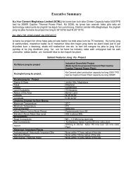
Executive Summaryprotectionwall- 11.59km,Breast wall- 501mGabion wall - 57.5mlength20.49 km (2 to 7m ht.)Extension of 5m wall- 4.63 kmGabion wall of 2m ht- 2.98 kmGabion wall at slope protection work-385m3.06 km by installing synthetic erosioncontrol mat etc. and rock bolts. (Slopeprotection measures will be taken asper IRC:56-1974)8 Bus stop Nil 17 at 10 location9 Toll plaza Nil 210 Truck parking Nil 111 Way sideAmenitiesNil 20.3 METHODOLOGY ADOPTED FOR EIA<strong>Environmental</strong> <strong>Impact</strong> <strong>Assessment</strong> (EIA) is the processes in which environmental factorsare integrated in to the project planning and decision making so as to achieve ecologicallysustainable development. Best practice EIA is to identify environmental risks, lessensconflict by community participation and minimizes the adverse environmental effects. Thishas to consider all environmental parameters that are likely to be impacted by a project.Such parameter may be physical, biological, Socio-economic and cultural.The process had involved Screening ; Scoping (Finalization of Terms of Reference at thisstage by Expert Appraisal Committee, MoEF); Preparation of <strong>Draft</strong> EIA report along with<strong>Impact</strong> analysis, mitigation measures, Environment monitoring and management plan;Public Consultation (present stage); preparation of final EIA report; Appraisal by the EACand then approval to the project if found environmentally sound.The <strong>Environmental</strong> Management and monitoring plan is developed along with costprovision, on the basis of potential impact analysis and possible mitigation measures, tomonitor implementation of mitigation measures on ground and provides detailed timeschedule and duration of monitoring measures. In developing the EIA/ EMP report, theEIA Guidance Manual – Highway by MoEF has been duly followed.0.4 REGULATORY FRAMEWORKReview of the existing legislation, institutions and policies relevant to the <strong>Environmental</strong><strong>Impact</strong> <strong>Assessment</strong> at the National and <strong>State</strong> levels has been done and clearancerequirements for the project at various stages of the project have been identified.The proposed rehabilitation and upgradation of NH 44 is between km 69.200 to km173.20 for a length of 104 km. In terms of the provision of Ministry of Environment andForests 2006 notification and subsequent amendments, this project is classified as acategory „ A‟ project” and requires <strong>Environmental</strong> clearance for execution since theproject requires an additional right of way greater than 20m and length is more than 30 m.It falls within 10 km of Interstate boundary (Assam / <strong>Meghalaya</strong>) and hence „GeneralCondition‟ applies. However, environmental clearance for the project stretch from Jowaikm 69.200 to Sonapur (km139.050) is already obtained (File No: 5-15/2008-1A-III dated10 th December 2008) for four lanning with 4 bypasses.Other requirement of obtaining the clearances from authorities at the state level for theproject is indicated in Table Es 2.Table Es 2: Clearance requirement for the present project<strong>Draft</strong> <strong>Environmental</strong> <strong>Impact</strong> <strong>Assessment</strong>Es - ii
![[FORM I] - Meghalaya State Pollution Control Board](https://img.yumpu.com/49771786/1/190x245/form-i-meghalaya-state-pollution-control-board.jpg?quality=85)