Draft Environmental Impact Assessment Report - Meghalaya State ...
Draft Environmental Impact Assessment Report - Meghalaya State ...
Draft Environmental Impact Assessment Report - Meghalaya State ...

You also want an ePaper? Increase the reach of your titles
YUMPU automatically turns print PDFs into web optimized ePapers that Google loves.
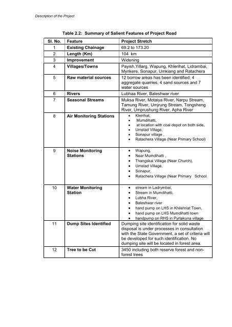
Description of the ProjectTable 2.2: Summary of Salient Features of Project RoadSl. No. Feature Project Stretch1 Existing Chainage 69.2 to 173.202 Length (Km) 104 km3 Improvement Widening4 Villages/Towns Payish,Yillarg, Wapung, Khlerihat, Lidrambai,Mynkere, Sonapur, Umkiang and Ratachera5 Raw material sources 12 borrow areas has been identified; 4aggregate quarries, 4 sand sources and 7water sources6 Rivers Lubhaa River, Baleshwar river7 Seasonal Streams Muksa River, Motaiya River, Narpu Stream,Tamung River, Umjrung Stream, TongshengRiver, Umprushung River, Apha River8 Air Monitoring Stations Kleirihat, Mumdihatti, at location with coal depot on both side, Umstad Village, Sonapur village , Ratachera Village (Near Primary School)9 Noise MonitoringStations Wapung, Near Mumdihatti , Thangskai Village (Near Church), Umstad Village, Sonapur, Ratachera Village (Near Primary School.10 Water Monitoring stream in Ladrymbai,Station Stream in Mumdihatti, Lubha River, Baleshwar river hand pump on LHS in Khilehriat Town, hand pump on LHS Mumdihatti town handpump on RHS in Pyrtakuna village11 Dump Sites Identified Dumping site identification for solid wastedisposal is under processes in consultationwith the <strong>State</strong> Government, a set of criteria willbe developed for such identification. Nodumping site will be located in forest area.12 Tree to be Cut 3450 including both reserve forest and nonforesttrees
![[FORM I] - Meghalaya State Pollution Control Board](https://img.yumpu.com/49771786/1/190x245/form-i-meghalaya-state-pollution-control-board.jpg?quality=85)