Meteorology Study Guide - Earth Science Regents Review
Meteorology Study Guide - Earth Science Regents Review
Meteorology Study Guide - Earth Science Regents Review

Create successful ePaper yourself
Turn your PDF publications into a flip-book with our unique Google optimized e-Paper software.
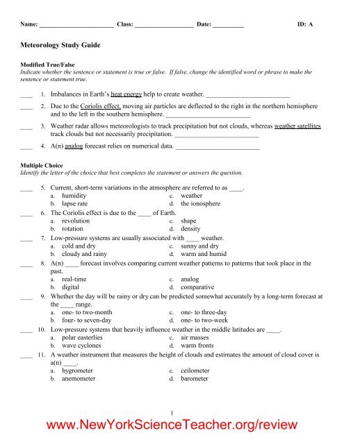
Name: ________________________ID: AProblem61. Fill in the chart below with the correct type of front. Use the following terms: cold front, occludedfront, stationary front, warm front.Movement of air massesAn advancing warm air mass displaces a cold air massand glides over the top of it.Two air masses with similar temperatures and pressuresmeet, and neither advances into the other's territory.A cold, dense air mass displaces a warm air mass andforces the warm air to rise steeply.A warm air mass is squeezed upward between two coldair masses.Type of fronta.b.c.d.62. Fill in the chart below with the names of the correct weather instruments. Use the following terms:anemometer, barometer, ceilometer, hygrometer, radiosonde, thermometer.What weather instrument doesMeasures relative humidity a.Measures temperature b.Measures height of cloud layers andestimates percentage of sky covered byclouds.Measures wind speed d.Measures air pressure e.Weather instrument namec.5www.NewYork<strong>Science</strong>Teacher.org/review
ID: A<strong>Meteorology</strong> <strong>Study</strong> <strong>Guide</strong>Answer SectionMODIFIED TRUE/FALSE1. T2. T3. T4. F, digitalMULTIPLE CHOICE5. C6. B7. B8. C9. C10. B11. C12. A13. B14. D15. C16. A17. B18. BMATCHING19. C20. A21. D22. B23. B24. D25. A26. CSHORT ANSWER27. climate28. weather1www.NewYork<strong>Science</strong>Teacher.org/review
ID: A29. Winds bring warm tropical air to colder areas and bring cooler polar air to warmer area, helping toovercome heat imbalances.30. A cool, dry air mass could move over a warm, moist part of <strong>Earth</strong>’s surface, such as a warm body ofwater. The air mass would then take on characteristics of the new surface beneath it, becomingwarmer and moister.31. Winds rotate around the centers of both systems. In a high-pressure system, air sinks at the centerand spreads outward at the surface. Winds move in a clockwise direction in the northern hemisphere.In a low-pressure system, air moves inward toward the center and rises. Winds move in acounterclockwise direction in the northern hemisphere.32. Meteorologists rely on accurate weather data to make reliable weather forecasts so that people can beinformed of significant changes in weather conditions and prepare for them.33. Meteorologists have technology that was unavailable 100 years ago. Satellites, computers, and radarare examples of technology that allow meteorologists to collect more precise data.34. Radiosondes allow meteorologists to create a profile of the temperature, air pressure, humidity, andwind speed/direction of a particular part of the troposphere. These data are important factors inmaking accurate forecasts.35. Both allow meteorologists to gather data about areas of precipitation. Traditional weather radarallows meteorologists to track the location of precipitation, whereas Doppler radar allowsmeteorologists to estimate wind speeds associated with areas of precipitation, including those inthunderstorms and tornadoes.36. Visible-light imagery doesn’t work in darkness, while infrared imagery does. Unlike visible-lightimagery, infrared imagery allows meteorologists to detect differences in thermal energy that canpinpoint cloud location and type, including large cumulonimbus clouds that can mean severeweather. Infrared imagery can also map surface temperatures, which visible-light imagery cannotdetect.37. Long-term forecasting involves predicting the interactions of numerous surface and upper-levelatmospheric factors. Over time, these factors interact to create progressively more complicatedscenarios.38. Both refer to the conditions of the atmosphere. However, weather refers to current atmosphericconditions, while climate refers to long-term weather patterns for an area.39. Both are global wind systems. The trade winds are easterlies that occur between 30° and the equatorin both the northern and southern hemispheres. The prevailing westerlies are westerlies that flowbetween 30° and 60° latitude north and south of the equator. The two systems have oppositecirculation patterns.40. Both involve the movement of weather systems. However, an air mass is a large body of air thattakes on the characteristics of the area over which it forms, while a front is a narrow regionseparating two air masses of different densities.41. Both are weather instruments. A thermometer measures temperature, while a barometer measures airpressure.42. Both are weather instruments. An anemometer measures wind speed and direction, while ahygrometer measures relative humidity.43. Both are methods of weather forecasting. The digital forecast relies on numerical data collected bymany weather instruments and analyzed by computers, while the analog forecast relies on comparingpast and current weather patterns.2www.NewYork<strong>Science</strong>Teacher.org/review
ID: A44. A large mass of air takes on the temperature and humidity characteristics of the land or water underit. An air mass redistributes energy by moving from place to place, transferring energy from one areato another.45. Jet streams are narrow bands of fast, high-altitude westerly winds that form as a result of greatdifferences in temperature and pressure between the boundaries of the major wind systems. Theyform in the midlatitudes between the polar easterlies and the prevailing westerlies, and between theprevailing westerlies and the trade winds.46. Cold fronts are associated with clouds, showers, and thunderstorms. Warm fronts are characterizedby extensive cloudiness and light precipitation. Stationary fronts usually are associated with lightprecipitation and light cloud cover, and, less frequently, weather similar to that of warm fronts.Occluded fronts are characterized by weather similar to warm fronts and cold fronts.47. Both are air masses that have taken on the characteristics of the area over which they formed. Acontinental polar air mass is cold and dry, having formed over polar land. A maritime tropical airmass is warm and humid, having formed over tropical oceans.48. Forecasts become less reliable when they attempt to predict long-term changes in weather. This isbecause many factors affect the weather and, over time, all these factors interact to createprogressively more complicated scenarios that are difficult to predict.49. Isobars that are closely spaced indicate a large pressure difference over a small area and strongwinds. Isobars that are far apart indicate a small pressure difference over an area and light winds.50. Wind systems exist because differences in temperature and air pressure create moving air. Withequal temperature and pressure all over the surface, there would be no global wind systems.51. Most likely, there is a high-pressure system over the area. High-pressure systems are characterized bysinking air, which works against the formation of clouds and precipitation.52. Possible response: Anemometer, thermometer, hygrometer, or ceilometer; these instruments wouldgive you data on wind speed, temperature, relative humidity, or cloud cover, which would be usefulin choosing clothing. The data from the barometer (air pressure) and radiosonde (high-level data)would be much less useful.53. It allows meteorologists to determine the temperature of a cloud. From this, they can infer the cloudtype and estimate its height. Because the strength of a thunderstorm is related to its height, infraredimagery gives data that can predict a storm’s potential severity. When people have advance warningof a severe storm, they can take precautions.54. Wednesday55. On Wednesday, there was rainfall and the associated increase in humidity.56. Clouds form at cold fronts, so clouds would have been visible as the front arrived.57. The pressure would have been lower on Wednesday, when the front was passing through with cloudsand precipitation.58. The high relative humidity indicates cloudy skies.59. They would be able to make a digital forecast if they knew how to express mathematically therelationships between the atmospheric variables they have collected. However, the forecast probablywould not be highly accurate because their data are not very dense.60. Possible answer: The temperature might be 18° or 19°C, since the trend seems to be risingtemperatures. The relative humidity has been falling for the past few days, so it is likely that Mondaywill have clear skies. Without air pressure data, however, it is difficult to make a guess as to whethera front is approaching.3www.NewYork<strong>Science</strong>Teacher.org/review
ID: APROBLEM61. a. warm frontb. stationary frontc. cold frontd. occluded front62. a. hygrometerb. thermometerc. ceilometerd. anemometere. barometer63. City B64. It is clear, 81° Fahrenheit, with light winds blowing at 1–3 mph. Students do not have to know winddirection.65. It is partly cloudy with about half the sky covered by clouds, 87° Fahrenheit, with light windsblowing at 1–3 mph. Students do not have to know wind direction.4www.NewYork<strong>Science</strong>Teacher.org/review