THE PORT OF MACKAY - North Queensland Bulk Ports Corporation
THE PORT OF MACKAY - North Queensland Bulk Ports Corporation
THE PORT OF MACKAY - North Queensland Bulk Ports Corporation

Create successful ePaper yourself
Turn your PDF publications into a flip-book with our unique Google optimized e-Paper software.
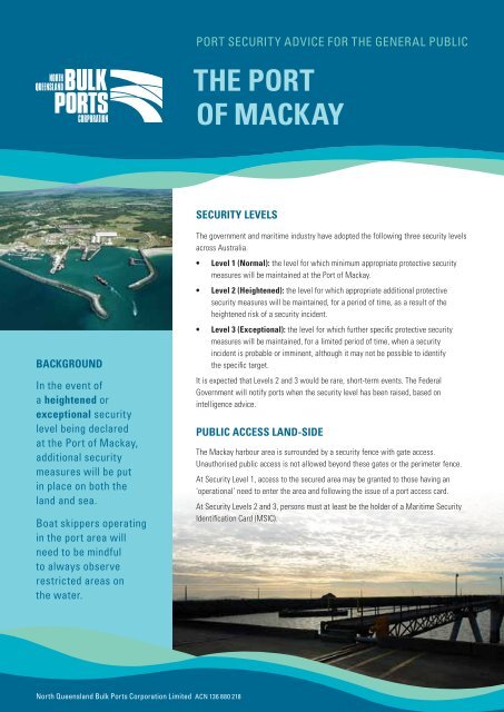
<strong>PORT</strong> SECURITY ADVICE FOR <strong>THE</strong> GENERAL PUBLIC<strong>THE</strong> <strong>PORT</strong><strong>OF</strong> <strong>MACKAY</strong>SECURITY LEVELSThe government and maritime industry have adopted the following three security levelsacross Australia.• Level 1 (Normal): the level for which minimum appropriate protective securitymeasures will be maintained at the Port of Mackay.• Level 2 (Heightened): the level for which appropriate additional protectivesecurity measures will be maintained, for a period of time, as a result of theheightened risk of a security incident.BACKGROUNDIn the event ofa heightened orexceptional securitylevel being declaredat the Port of Mackay,additional securitymeasures will be putin place on both theland and sea.Boat skippers operatingin the port area willneed to be mindfulto always observerestricted areas onthe water.• Level 3 (Exceptional): the level for which further specific protective securitymeasures will be maintained, for a limited period of time, when a securityincident is probable or imminent, although it may not be possible to identifythe specific target.It is expected that Levels 2 and 3 would be rare, short-term events. The FederalGovernment will notify ports when the security level has been raised, based onintelligence advice.PUBLIC ACCESS LAND-SIDEThe Mackay harbour area is surrounded by a security fence with gate access.Unauthorised public access is not allowed beyond these gates or the perimeter fence.At Security Level 1, access to the secured area may be granted to those having an‘operational’ need to enter the area and following the issue of a port access card.At Security Levels 2 and 3, persons must at least be the holder of a Maritime SecurityIdentification Card (MSIC).<strong>North</strong> <strong>Queensland</strong> <strong>Bulk</strong> <strong>Ports</strong> <strong>Corporation</strong> Limited ACN 136 880 218
Mackay Water-side Mackay Restricted Water-side Zone Restricted Zone21°06'19.47"S149°12'58.64"E(railway gate)21°06'34.36"S149°13'01.49"Eboundary follows security fencebetween two railway lines21°06'33.94"S149°13'03.26"E(security gate)21°06'39.15"S149°13'05.82"Esecurity fencing21°05'56.24"S149°13'06.68"E(railway gate)21°06'27.27"S149°12'58.63"E(railway gate)securityfencingsecurity21°06'45.31"S149°13'09.04"Efencesecurity21°06'32.37"S149°13'21.81"Esec.fencefencing21°06'06.09"S149°13'28.70"E21°06'19.58"S149°13'23.54"Esecurity fencing21°06'45.58"S149°13'20.52"EWater SideRestricted Zone100 50 0 100 20021°06'30.93"S149°13'33.04"E21°06'31.02"S149°13'23.52"EHigh Water Marksecurity fencing21°06'33.14"S149°13'32.88"E50 25 0 50 100Meters1:5,000See InsetMetersater-side RestrictedLegendZonesecurity21°06'33.93"S149°13'33.15"ELand-side Restricted ZoneWater-side Restricted Zone21°06'03.39"S149°13'25.70"EHigh21°06'32.06"S149°13'33.83"EHigh Water Mark21°06'33.83"S149°13'20.74"EWharf under constructionLovesJetty21°06'03.33"S149°13'26.25"E(security gate)21°06'07.14"S149°13'44.65"Esecuritygate21°06'10.62"S149°13'37.60"EMarkWaterfencingBerthsAbbot Point Water-side Restricted Zone21°06'34.94"S149°13'40.52"Esecurity fencing21°06'19.82"S149°13'26.57"E21°06'32.21"S149°13'37.25"EHigh Water21°06'33.51"S149°13'35.15"E21°06'34.00"S149°13'40.41"EMarkNo 5. WharfHighLeeSouthern BreakwaterBreast Wharf21°06'35.35"S149°13'44.54"E100 50 0 100 200Meters21°06'07.81"S149°13'44.20"E21°06'16.27"S149°13'56.61"EWater21°06'11.88"S149°13'43.16"E21°06'24.74"S149°13'38.26"EBreakwaterMark21°06'32.64"S149°13'40.57"E21°06'33.09"S Legend149°13'44.82"ELand-side Restricted Zone21°06'34.45"SWater-side Restricted Zone149°13'44.67"EFace of wharfsecurity fencingWaterHighunfenced100 50 0 100 200MetersMark21°06'35.09"S149°13'46.90"E100 50 0 100 200MetersPUBLIC ACCESS WATER-SIDEThere is no unauthorised access to theMackay Port Water-side Restricted Zone(WRZ) at any security level.BREACHING <strong>PORT</strong>SECURITY ZONESLegendLand-SideRestricted ZoneBreaking these restrictions wouldWater-sideRestricted Zonejeopardise the security and operation ofthe port, and anyone caught breachingthe rules faces serious fines. All of theoperators at the port and the enforcementagencies have been instructed to be onthe look out for breaches and will adopta zero tolerance.The Mackay port facilities are critical tothe interests of <strong>Queensland</strong> and Australiaand the security of these facilities willbe enforced. Breaches of security accessrestrictions may bring fines of upto $5,000.SEA<strong>PORT</strong>COMMUNITY SUP<strong>PORT</strong><strong>OF</strong> <strong>PORT</strong> SECURITYATTENTION - PLEASE READ CAREFULLYTHIS IM<strong>PORT</strong>ANT DISCLAIMER NOTICE1. No person should act in reliance upon theabove/attached map/s ("the Maps"), withoutfirst obtaining advice from a licensed surveyor orother qualified consultant.2. NORTH QUEENSLAND BULK <strong>PORT</strong>S ("NQBP"):-(a) gives no representation or warranty as to theaccuracy of the information shown on the Maps;(b) accepts no responsibility for any errors in,or omissions from, the Maps; and(c) is not responsible for any action taken inreliance, wholly or partially, upon the Maps, whichaction is taken at your sole risk absolutely.3. The Maps are provided by NQBP on an"as is/ where is" basis.4. The Maps may include information obtainedfrom third parties and (without limiting paragraph2(a)) there may be inaccuracies and errors inthat information.5. NQBP expressly disclaims and excludes, tothe extent it is lawfully able:-(a) all warranties, express or implied, relating tothe Maps or the use of, or reliance upon, thesame; and(b) all and all liability to any person, whether apurchaser, reader or user of the Maps orotherwise ("an Affected Person") for:-(i) the death of or injury to; or(ii) damage to any property of; or(iii) losses, claims, demands, actions,proceedings, damages, costs or expenses(including, without limitation, consequentiallosses, loss of profits, loss of use, loss ofefficiency, pure economic loss and any similarlosses) or other liability whatever suffered orincurred by any Affected Person, or anyoneclaiming under an Affected Person, arisingdirectly or indirectly out of use of, or reliance upon,the Maps or any of them, or any part thereof.6. As to any term implied by statute into your useof the Maps and which statute precludes theexclusion of such term, the liability of NQBP for anybreach of that term is limited (so far as lawfully canbe) to the re-supply of the Maps.7. Subject to the provisions of the Copyright Act1968 (Cth), the Maps must not be re-produced forany purpose whatsoever, without the prior writtenconsent of NQBP.Apart from observing the accessrestrictions, the general public and boatowners are asked to be on the look out forany suspicious behaviour. This should bereported to port and terminal authorities.Your co-operation would be much valued.These security measures have beenimplemented Australia-wide and NQBP,the Mackay Port operators, as well as themaritime industry generally, ask for yourunderstanding and assistance in meetingour security obligations.- GIS Section -06.09"S'28.70"E.58"S.54"E21°06'03.39"S149°13'25.70"EghHigh Water Mark21°06'03.33"S149°13'26.25"E(security gate)21°06'07.14"S149°13'44.65"Esecuritygate21°06'10.62"S149°13'37.60"E60m frommooring dolphinMark19°51'27.39"S148°04'55.48"E19°51'26.03"S148°04'58.15"E60m frommooring dolphinBerthssecurity fencing19°51'22.17"S148°04'57.37"E21°06'19.82"S149°13'26.57"ENo 5. Wharf19°51'25.67"S60m off backof wharfHighLeeBerth 1face of wharf21°06'07.81"S149°13'44.20"E21°06'16.27"S149°13'56.61"EWater21°06'11.88"S148°05'01.85"E149°13'43.16"E21°06'24.74"S149°13'38.26"EBreakwaterMarkback of wharf60m off faceof wharfLegendLand-Side InsetMeters Restricted Zone1:5,000Water-sideRestricted Zone50 25 0 50 10019°51'28.52"S148°05'10.70"E19°51'30.3"S148°05'14.0"E60m frommooring d19°51'28.4"S148°05'16.9"EATTENTION - PLEASE READ CAREFULLYTHIS IM<strong>PORT</strong>ANT DISCLAIMER NOTICEFOR INFORMATION PLEASE CONTACT:1. No person should act in reliance upon theabove/attached map/s ("the Maps"), withoutfirst obtaining advice from a licensed surveyor orother qualified consultant.2. NORTH QUEENSLAND BULK <strong>PORT</strong>S ("NQBP"):-(a) gives no representation or warranty as to theaccuracy of the information shown on the Maps;<strong>North</strong> (b) accepts no <strong>Queensland</strong> responsibility for any errors in, <strong>Bulk</strong> <strong>Ports</strong> <strong>Corporation</strong> Limitedor omissions from, the Maps; and(c) is not responsible for any action taken inreliance, wholly or partially, upon the Maps, whichaction is taken at your sole risk absolutely.Port3. The MapsSecurityare provided by NQBPOfficer:on an07 4955 8174"as is/ where is" basis.4. The Maps may include information obtainedfrom third parties and (without limiting paragraphDeputy 2(a)) there may be Port inaccuracies Security and errors in Officer: 07 4955 5107that information.5. NQBP expressly disclaims and excludes, tothe extent it is lawfully able:-(a) all warranties, express or implied, relating tothe Maps or the use of, or reliance upon, thesame; and(b) all and all liability to any person, whether apurchaser, reader or user of the Maps orotherwise ("an Affected Person") for:-(i) the death of or injury to; or(ii) damage to any property of; or(iii) losses, claims, demands, actions,proceedings, damages, costs or expenses(including, without limitation, consequentialFor more information about who we are and what we do, visit our website: www.nqbp.com.auWater