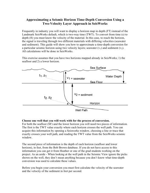
Approximating a horizon time-depth conversion using a two-velocity ...
Approximating a horizon time-depth conversion using a two-velocity ...
Approximating a horizon time-depth conversion using a two-velocity ...

You also want an ePaper? Increase the reach of your titles
YUMPU automatically turns print PDFs into web optimized ePapers that Google loves.
<strong>Approximating</strong> a Seismic Horizon Time-Depth Conversion Using aTwo-Velocity Layer Approach in SeisWorksFrequently in industry you will want to display a <strong>horizon</strong> map in <strong>depth</strong> (FT) instead of theLandmark SeisWorks default, which is <strong>two</strong>-way <strong>time</strong> (TWT). To convert from <strong>time</strong> (s) to<strong>depth</strong> (ft) you must know the <strong>velocity</strong> of the material. In this case, to reach the <strong>horizon</strong>,the signal is traveling through <strong>two</strong> different materials with differing velocities (seawaterand sediment). This guide will show you how to approximate a <strong>time</strong>-<strong>depth</strong> <strong>conversion</strong> fora particular seismic <strong>horizon</strong> <strong>using</strong> <strong>two</strong> <strong>velocity</strong> layers; seawater (v 1 ) and sediment (v 2 ).All calculations will be done in SeisWorks.This exercise assumes that you have <strong>two</strong> <strong>horizon</strong>s mapped already in SeisWorks; 1) theseafloor and 2) a lower <strong>horizon</strong>.Choose one well that you will work with for the process of <strong>conversion</strong>.For both the seafloor (SF) and the lower <strong>horizon</strong> you will need <strong>two</strong> pieces of information.The first is the TWT value exactly where each <strong>horizon</strong> crosses the well path. You canacquire this information by opening a Seisworks window, choosing a line or trace thatexactly crosses your well path, and reading the TWT value from the SeisWorks seismicwindow.The second piece of information is the <strong>depth</strong> of each <strong>horizon</strong> (seafloor and lower<strong>horizon</strong>), in feet, from the Bob Brown database. If you do not have access to thisinformation you can get it from Heather or one of the grad students working on theproject. As an aside - When looking at the well path in the Seismic View ignore the picksshown on the well, they don’t mean anything because you don’t know what <strong>time</strong>-<strong>depth</strong><strong>conversion</strong> was used to calculate these values.Before you begin your <strong>conversion</strong> you must first calculate the <strong>velocity</strong> of the seawaterand the <strong>velocity</strong> of the sediment in feet per second.
Velocity of the seawater:SF pick in feet/(SF TWT/2/1000) = <strong>velocity</strong> of seawater in ft/sYou must divide the <strong>time</strong> by 2 to get one way <strong>time</strong> and then divide by 1000 to convertfrom ms to seconds.Example: 2873ft/(1165.45ms/2/1000) = 4930.50 ft/s = <strong>velocity</strong> of water columnVelocity of the sediment:z2− z1Sediment Velocity =t2− t1where z = <strong>depth</strong> of pick in feet, and t = TWT where <strong>horizon</strong> crosses the well path (ms)1 refers to the seafloor, 2 to the lower <strong>horizon</strong>You must divide the <strong>time</strong> by 2 to get one way <strong>time</strong> and then divide by 1000 to convertfrom ms to seconds.Example: (15368.7ft – 2873ft)/(4582.93ms-1165.45ms) = 12495.7/3417.48Must divide the <strong>time</strong> by 2 and then by 1000 to convert to one-way <strong>time</strong> in seconds3417.48/2/1000 = 1.709So, 12495.7/1.709 = 7311.70 ft/s = <strong>velocity</strong> of the sedimentYou are now ready to perform the calculations in SeisWorks:STEP 1: CONVERT SEAFLOOR (SF) FROM TWT TO FTThe basic calculation is as follows:For the seafloor: Start with the SF in TWT (ms)Divide by 2 to get one-way <strong>time</strong>Divide by 1000 to convert ms into secondsMultiply by <strong>velocity</strong> of water (ft/s) (See calculation above)In SeisWorks seismic viewHorizon -> Computations -> StandardClick on “Horizon (oper) Constant” and choose your SF <strong>horizon</strong>Multiply by the above constant. SeisWorks will not accept decimal numbers, so you willhave to input the number as an exponent (for example 2465 x 10 -3 for 2.465). Choose aname for your output file and click “OK”.STEP 2: CALCULATE SEDIMENT THICKNESS IN TWTThe basic calculation is as follows:Subtract the SF in TWT from the <strong>horizon</strong> in TWT to get sediment thicknessIn SeisWorks seismic viewHorizon -> Computations -> StandardClick on “Horizon (oper) Horizon” and choose your lower <strong>horizon</strong> in TWTChoose Subtract, then enter the name of your SF <strong>horizon</strong> in TWT. Choose a name foryour output file and click “OK”.
STEP 3: CONVERT SEDIMENT THICKNESS FROM TWT TO FTThe basic calculation is as follows:Divide by 2 to get one-way <strong>time</strong>Divide by 1000 to get ms into secondsMultiply by <strong>velocity</strong> of sediment (ft/s) (See calculation above)In SeisWorks seismic viewHorizon -> Computations -> StandardClick on “Horizon (oper) Constant” and choose your output from step 2. Multiply by theabove sediment constant. SeisWorks will not accept decimal numbers, so you will haveto input the number as an exponent (for example 2465 x 10 -3 for 2.465). Choose a namefor your output file and click “OK”.STEP 4: ADD SEDIMENT THICKNESS (FT) TO SEAFLOOR (FT) TO GETTOTAL DEPTH OF THE HORIZON (FT)The basic calculation is as follows:Add the SF in FT to the <strong>horizon</strong> in FT to get a total <strong>depth</strong> to the <strong>horizon</strong> in FT.In SeisWorks seismic viewHorizon -> Computations -> StandardClick on “Horizon (oper) Horizon” and choose your output from step 3. Add the outputfrom step 1. Choose a name for your output file and click “OK”.You can now view this <strong>horizon</strong> in SeisWorks Map View. Click on View -> Contents,choose your new <strong>horizon</strong> file and change your color bar to reflect the <strong>depth</strong> of your<strong>horizon</strong> in feet.