Proceedings of 14th International conference „Maritime Transport and Infrastructure - <strong>2012</strong>”consistent ice packs located? (2) Where is the shell ice, lightercompounded ice located? (3) Where arethe crevasses accessible for navigation and, ultimately: most optimal course of voyage for getting intothe ice-free waters with minimal efforts and related risks?The basis of this method is deployment of UVA on short notice, as well as to get protractedvisual image of ice situation around the ship, compared with this view from bridge. Once this methodis used, command and control of UAV is being conducted by means of ‘’direct control”, or control bythe method of pre-planned waypoints. In particular situations, when ice-fields have to be crossedwithin restricted geographical areas, the ‘’direct control ‘’ of UAV is better suited, because it is moresimplistic and enables fast camera’s switching from ‘’perspective’’ to ‘’detailed’’ mode of view andobservation. The mode of ‘’perspective observation’’ is being executed on the certain altitude of flight,where the water space is being best visually embraced from, thus delivering better qualitycomprehension about ice conditions in surroundings. Altitude of flight is also constrained by cloudbase height and air visibility.In order to execute the surveillance pattern by method of Perspective surveillance (Fig.2),UAV is being raised up to definite altitude H, with further surveillance route in transversal plane togeneral course CoG. The flight is being executed within the range of ‘’direct control’’ from the ship,which is located at point O. First surveillance route dc delivers the factual visual data and informationwithin defined water zone ABCD. In case if acquired data do not provide sufficient information foroptimal route selection, then flight is being switch over to automated mode, when UAV proceedsbetween pre-planned waypoints. The automated mode’s waypoints should be designated consideringthe transverse ‘’sweep range’’ from initial surveillance track dc, in order to prevent surveillance gapsand blank spots. It means that for the sake of reliable data from two adjacent flying surveillance tracks,there should be 20-30% coverage overlap.Upon the initial visual screening, once preliminary data and information has been acquiredabout crevasses in ice-fields, ice thickness, ice concentration and availability of ice-free water space, aseafarer comes to a decision on further surveillance: if deemed necessary to get more detailed visualdata from certain areas.Fig. 2. The method of perspective surveillanceAdditional surveillance is being conducted by the method of ‘’Detailed Surveillance’’, whenthe flight is being executed on the low altitude with the main purpose to rectify ice conditions insurroundings and to eliminate doubts about most optimal ship’s course selection. DetailedSurveillance utilizes such the camera’s generous features like in-zooming of an object and/orobserving a particular object from different angles of view.In the process of Detailed Surveillance ice crevasses and ice-openings are being surveyed,with the aim to clarify their sizing and dimensions.60
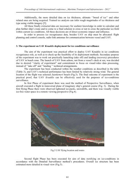
Proceedings of 14th International conference „Maritime Transport and Infrastructure - <strong>2012</strong>”Additionally, the more detailed data on ice thickness, ultimate ‘’breed of ice’’ and otherrelated ones are being acquired. Trained ice analysts can infer rough magnitudes of ice thickness andtype using visible imagery [5].All these finally extracted data are necessary for seafarer knowledge in order to calculate andplan further ship’s route and to come to a final solution to cross or not to cross the particular ice-fieldwithin current ice conditions. All these decisions are of direct economic impact and influence.In order to process ice recognisance data, besides UAV on ship must be allocated: flightplanning and control console, radio link antennas for communication between vessel and UAV.3. The experiment on UAV Krauklis deployment for ice conditions surveillanceThe aim of the experiment was practical effort to deploy UAV Krauklis in ice conditionsrecognisance role, as well as to check up the feasibility of its deployment methods. Secondary purposeof the experiment was to work out practically launching (take off) and landing (recovery) proceduresof UAV in beach zone. The launch of UAV from ashore, not from a vessel’s deck at sea, was decideddue to desired ‘’clarity of experiment” and commitment to focus on visual/video data processing,instead of ‘’take off” and ‘’landing ‘’ technical arrangements.The experiment has been conducted within the weather conditions as described in the table(Table 3), and UAV’s technical performance has been limited by relatively strong wind. The generallocation of the flight was selected Jaunkemeri beach (Fig.3). The final outcome of experiment is thepractical proof, that UAV Krauklis can be effectively used for the purposes of ice-conditionssurveillance.In first Phase of experiment there was used the method of Perspective Surveillance, whenaircraft executed a flight in transversal plane of imaginary ship’s general course (Fig. 3). During thefirst flying Phase there were observed tightened ice-packs, snowdrifts, and there was visually visibleice-free water space in a remote viewing perspective (Fig.4).Fig.3 UAV flying location and routesSecond flight Phase has been executed for aim of data rectifying on ice-conditions inaccordance with the Detailed Surveillance method’s procedures. Overall ice structure has beenestimated more detailed in visual view (Fig.5).61