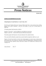
9350 VERŻJONI ONLINE<strong>Gazzetta</strong> <strong>tal</strong>-<strong>Gvern</strong> ta’ <strong>Malta</strong> 18,784It-Tlieta 9 ta’ Awwissu 2011 bejn id-9.00 a.m. u n-12.30p.m. u bejn 7.00 p.m. u l-11.30 p.m.L-Erbgħa 10 ta’ Awwissu 2011 bejn it-8.00 a.m. unofsinhar u bejn is-7.00 p.m. u l-11.00 p.m.Il-barkun li se jintuża biex minn fuqu jinħarqu l-mur<strong>tal</strong>i sejkun irmiġġat nhar it-Tnejn 8 ta’ Awwissu, 2011 bejn il-Ponta ta’Sant’ Anġlu u l-Ponta ta’ Bighi fil-pożizzjoni li ġejja:Latitude (T)Longitude (L)35°53’.645 14°31’.290Il-ħruq <strong>tal</strong>-mur<strong>tal</strong>i mill-barkun se jsir kif ġej:It-Tlieta, 9 ta’ Awwissu 2011 bejn il-10.00 p.m. u l-11.30p.m.L-Erbgħa, 10 ta’ Awwissu 2011 bejn is-7.00 p.m. u t-8.30p.m.Għandha tinżamm distanza ta’ 200 metru mill-Pontata’ Bighi u mill-pożizzjoni <strong>tal</strong>-barkun fid-dati u l-ħinijietimsemmija hawn fuq. Il-baħħara għandhom ibaħħrub’kawtela u bilmod u jobdu l-ordnijiet u d-direzzjonijietmill-Valletta Port Control.Chart affettwata: BA Chart 177.Il-pożizzjonijiet jirreferu għal WGS 84 Datum.Id-29 ta’ Lulju, 2011Tuesday 9th August 2011 between 9.00 a.m. and 12.30p.m. and between 7.00 p.m. and 11.30 p.m.Wednesday 10th August 2011 between 8.00 a.m. andnoon and between 7.00 p.m. and 11.00 p.m.The barge to be used for firework displays shall bemoored on Monday 8th August, 2011 between St AngeloPoint and Bighi Point in the following position:Latitude (N)Longitude (E)35°53’.645 14°31’.290Firework displays from the barge will be let off asfollows:Tuesday, 9th August 2011 between 10.00 p.m. and 11.30p.m.Wednesday, 10th August 2011 between 7.00 p.m. and8.30 p.m.A wide berth of 200 meters is requested from Bighi Pointand from the position of the barge on the days and timesindicated above. Mariners are to navigate with caution andslow speed. Instructions and directions given by VallettaPort Control are to be compiled with.Chart affected BA Chart 177.Positions are referred to WGS 84 Datum.29th July, 2011Transport <strong>Malta</strong>Avviż lill-Baħħara Nru. 72 <strong>tal</strong>-2011Marine Aids Ġodda għat-TbaħħirId-Direttorat <strong>tal</strong>-Portijiet u Yachting, Transport <strong>Malta</strong>,jgħarraf lill-baħħara li b’seħħ immedjat se jitqiegħdu erba’ (4)żubruni biex jimmarkaw diversi sikek.Qed issir riferenza għal BA Chart 211A, 2537 u 2538Iż-żubruni ċilindriċi għandhom dijametru ta’ 1.5 metri,għandhom torri ta’ 2m ’l fuq minn wiċċ il-baħar u għandhomdwal li jwasslu sa żewġ mili nawtiċi. Dawn se jitqiegħdu filpożizzjonijietli ġejjin:Transport <strong>Malta</strong>Notice to Mariners No. 72 of 2011New Marine Aids to NavigationThe Ports and Yachting Directorate, Transport <strong>Malta</strong>,notifies mariners that with immediate effect four (4) buoyswill be placed to delineate several reefs.Reference is made to BA Chart 211A, 2537 and 2538The cylindrical buoys are 1.5 metres in diameter, havea rectangular tower 2m high above the water level and arefitted with lights with a range of 2 Nautical Miles. These willbe placed in the following positions:Bajjiet Tip Latitude (T) Longitude (L)Bays Type Latitude (N) Longitude (E)1 Marsalforn Port Hand Lateral Mark 36º 04’.49 14º 15’.662 Comino West Cardinal Mark 36º 01’.04 14º 19’.203 Qawra (Ghallis Rocks) North Cardinal Mark 35º 57’.31 14º 26’.844 Gnejna Bay North Cardinal Mark 35º 55’.47 14º 20’.09
Id-29 ta’ Lulju, 2011 VERŻJONI ONLINE9351Il-baħħara għandhom jiftakru li ħadd ma jista’ jirmiġġakwalunkwe inġenji <strong>tal</strong>-baħar ma’ xi wieħed miż-żubruni <strong>tal</strong>-Awtorità msemmija.Il-pożizzjonijiet kollha jirreferu għal WGS 84 DATUM.Id-29 ta’ Lulju, 2011Mariners are reminded that it is prohibited to moor anycraft with any of the above buoys or any other buoy ownedby the Authority.All positions are referred to WGS 84 DATUM.29th July, 2011Transport <strong>Malta</strong>Avviż lill-Baħħara Nru. 73 <strong>tal</strong>-2011Żubruni Speċjali li jimmarkaw Żoni ta’ 200 metruta’ Veloċità RistrettaId-Direttorat <strong>tal</strong>-Portijiet u Yachting, Transport <strong>Malta</strong>,jgħarraf li b’seħħ immedjat tqiegħdu diversi żubruni speċjalimadwar il-Gżejjer Maltin biex jimmarkaw żoni ta’ 200 metruta’ veloċità ristretta (10 Knots u 5 Knots) ’l hinn mix-xatt.It-tqegħid taż-żubruni huwa staġjonali u se jdum sa Ottubru,għalkemm jistgħu jibqgħu mwaħħlin sa wara din id-data.BA Chart 2537, 211AŻubruni speċjali ta’ 1.5 dijametru, b’dawl li jteptepdarba kull erba’ sekondi u jwassal sa żewġ mili nawtiċi, sejitqiegħdu f’dawn il-pożizzjonijiet:Transport <strong>Malta</strong>Notice to Mariners No. 73 of 2011Special Mark Buoys Delineating the 200-metre SpeedRestriction ZonesThe Ports and Yachting Directorate, Transport <strong>Malta</strong>,notifies that with immediate effect several special markerbuoys will be placed around the Maltese Islands to delineatethe 200-metre speed restriction zones (10 Knots and 5 Knots) from the shore. The placement of the buoys is seasonaluntil October but may still be in place after this date.BA Chart 2537, 211ASpecial Mark Buoys 1.5 metres in diameter, fitted with alight flashing 1 every 4 seconds and 2 Nautical Miles range,shall be placed in the following positions:Bajjiet Veloċità Latitude (T) Longitude (L)Bays Speed Latitude (N) Longitude (E)A 1 Marsalforn 10 Knots 36º 04’.564 14º 15’.843A 2 Comino 10 Knots 36º 01’.303 14º 20’.379A 3 Qawra 10 Knots 35º 57’.732 14º 25’.817A 4 Dragonara Pt. 10 Knots 35º 55’.688 14º 29’.836A 5 Dragut Pt. 10 Knots 35º 54’.500 14º 31’.007BA Chart 2537, 2538, 211A, 211B, 36B’żieda ma’ dan żubruni ċilindriċi sofor b’dijametruta’ 0.9 metri, li jteptpu darba kull erba’ sekondi u li d-dawl tagħhom iwassal sa żewġ mili nawtiċi, tqiegħdu filpożizzjonijietli ġejjin:BA Chart 2537, 2538, 211A, 211B, 36Further to the above yellow cylindrical buoys whichare 0.9 metres in Diameter, flashing 1 every 4 seconds andhaving 2 Nautical Miles range, have been placed in thefollowing positions:Bajjiet Veloċità Latitude (T) Longitude (L)Bays Speed Latitude(N) Longitude (E)B 1 Ramla l-Hamra 10 Knots 36º 03’.827 14º 17’.018B 2 Mgarr ix-Xini 5knots 36º 00’.906 14º 16’.445B 3 Santa Marija 10 Knots 36º 01’.216 14º 20’.108B 4 San Niklaw 10 Knots 36º 01’.264 14º 19’.804B 5 Blue Lagoon 5knots 36º 01’.004 14º 19’.226B 6 Cirkewwa 10 Knots 35º 59’.059 14º 19’.789
- Page 1: Il-Ġimgħa, 29 ta’ Lulju, 2011Fr
- Page 4 and 5: 9338 VERŻJONI ONLINEGazzetta tal-G
- Page 6 and 7: 9340 VERŻJONI ONLINEGazzetta tal-G
- Page 8 and 9: 9342 VERŻJONI ONLINEGazzetta tal-G
- Page 10 and 11: 9344 VERŻJONI ONLINEGazzetta tal-G
- Page 12 and 13: 9346 VERŻJONI ONLINEGazzetta tal-G
- Page 14 and 15: 9348 VERŻJONI ONLINEGazzetta tal-G
- Page 18 and 19: 9352 VERŻJONI ONLINEGazzetta tal-G
- Page 21 and 22: Id-29 ta’ Lulju, 2011 VERŻJONI O
- Page 23 and 24: Id-29 ta’ Lulju, 2011 VERŻJONI O
- Page 25 and 26: Id-29 ta’ Lulju, 2011 VERŻJONI O
- Page 27 and 28: Id-29 ta’ Lulju, 2011 VERŻJONI O
- Page 29 and 30: Id-29 ta’ Lulju, 2011 VERŻJONI O
- Page 31 and 32: Id-29 ta’ Lulju, 2011 VERŻJONI O
- Page 33 and 34: Id-29 ta’ Lulju, 2011 VERŻJONI O
- Page 35 and 36: Id-29 ta’ Lulju, 2011 VERŻJONI O
- Page 37 and 38: Id-29 ta’ Lulju, 2011 VERŻJONI O
- Page 41: Id-29 ta’ Lulju, 2011 VERŻJONI O
- Page 46 and 47: 9380 VERŻJONI ONLINEGazzetta tal-G
- Page 48 and 49: 9382 VERŻJONI ONLINEGazzetta tal-G
- Page 50 and 51: 9384 VERŻJONI ONLINEGazzetta tal-G
- Page 52 and 53: 9386 VERŻJONI ONLINEGazzetta tal-G
- Page 54 and 55: 9388 VERŻJONI ONLINEGazzetta tal-G
- Page 56 and 57: 9390 VERŻJONI ONLINEGazzetta tal-G
- Page 58 and 59: 9392 VERŻJONI ONLINEGazzetta tal-G
- Page 60 and 61: 9394 VERŻJONI ONLINEGazzetta tal-G
- Page 62 and 63: 9396 VERŻJONI ONLINEGazzetta tal-G
- Page 64 and 65: 9398 VERŻJONI ONLINEGazzetta tal-G
- Page 66 and 67:
9400 VERŻJONI ONLINEGazzetta tal-G
- Page 68 and 69:
9402 VERŻJONI ONLINEGazzetta tal-G
- Page 70 and 71:
9404 VERŻJONI ONLINEGazzetta tal-G
- Page 72 and 73:
9406 VERŻJONI ONLINEGazzetta tal-G
- Page 74 and 75:
9408 VERŻJONI ONLINEGazzetta tal-G
- Page 76 and 77:
9410 VERŻJONI ONLINEGazzetta tal-G
- Page 78 and 79:
9412 VERŻJONI ONLINEGazzetta tal-G
- Page 80 and 81:
9414 VERŻJONI ONLINEGazzetta tal-G
- Page 82 and 83:
9416 VERŻJONI ONLINEGazzetta tal-G
- Page 84 and 85:
9418 VERŻJONI ONLINEGazzetta tal-G
- Page 86 and 87:
9420 VERŻJONI ONLINEGazzetta tal-G
- Page 88 and 89:
9422 VERŻJONI ONLINEGazzetta tal-G
- Page 90 and 91:
9424 VERŻJONI ONLINEGazzetta tal-G
- Page 92 and 93:
9426 VERŻJONI ONLINEGazzetta tal-G
- Page 94:
9428 VERŻJONI ONLINEGazzetta tal-G