City of Darebin Heritage Study Volume 1 Draft Thematic
City of Darebin Heritage Study Volume 1 Draft Thematic City of Darebin Heritage Study Volume 1 Draft Thematic
DAREBIN HERITAGE STUDY STAGE 2Brickworks then a council tip. The Ray Bramham Gardens are on the site of the CliftonBrickworks.Darebin Parklands was formerly the large bluestone quarry worked by John Sharp Adams ofAlphington from 1906. The site became the Alphington tip in 1966, and the surrounding landwas used for horse agistment. After the tip closed in 1975 local residents campaigned for theland to be made into a park. Northcote Council purchased the site and revegetation workswere undertaken by park rangers and local residents to restore the natural bushland. In 1979local volunteers assisted Sidney Clifton to construct a pedestrian bridge over Darebin Creek tolink the park with Rockbeare Park on the opposite side. Darebin Park is regarded as a pioneerof urban land reclamation and revegetation (“Darebin Parklands”).Darebin Creek Reserve where it interrupts Rathcown Road at Reservoir was mostly a swamp,which used to pose a hazard to people walking along Purinuan Road, especially in the dark(Jones, 1994:87). It is now parkland.Rescuing creeksBy the 1960s, creeks were the unsafe and ugly backs to lesser valued properties, but thepotential for their rehabilitation began to be recognised. Community interest in linearparklands and habitat creation led to acquisitions of parkland and development of trails and,Creek Management Committees formed.Merri Merri Park in Northcote, was a Melbourne Water Depot. When Melbourne Waterdecided to build a concrete flood levee there, the community and the Merri CreekCoordination Committee persuaded them to create an earthen levee in a parkland landscapedsetting with indigenous species instead. The park is now a popular area for walking andrelaxing.Another levee project on the north side of Normanby Avenue to Strettle Reserve on MerriCreek led to the conversion of industrial land to parkland along the Creek. Groves’ land, offMerri Parade in Northcote, held the Groves timber latticework factory up until the early1990s, on flood-prone land adjacent to Merri Creek. The area was converted to semi-naturalparkland with funding from Council and Melbourne Water.Street plantingsStreet beautification was an expression of civic pride. In 1885, around the same time as theNorthcote Park was planted, a row of elm trees was planted at Northcote’s High Streetentrance. As Northcote began to be re-discovered by people looking for suburban land, theNorthcote South Ratepayers Association, formed in 1901, did some further beautificationwork to ‘greatly impress visitors, and cause many to settle amongst us’. The plantings of lawnsand flower beds were completed in 1905. In 1913, the Northcote South RatepayersAssociation installed two cannons, which had formerly protected the South Channel in PortPhillip Bay, at the garden entrance. According to the writer of ‘Glimpses of our Past’ (p.5) therockeries were constructed in the 1930s at the same time as those at Northcote Park, however amuch earlier photograph, possibly taken at the time the cannons were installed, shows therockeries already in place (Lemon, 1983:142, 160-61).Figure 51Cannon on HighStreet, Northcote,1975Photographer:John T. Collins[State Library ofVictoria, AN:H98.250/1311,INjc013003]82
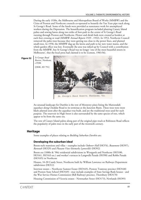
VOLUME 2: THEMATIC ENVIRONMENTAL HISTORYDuring the early 1930s, the Melbourne and Metropolitan Board of Works (MMBW) and theCities of Preston and Northcote councils co-operated to beautify the Yan Yean pipe track alongSt George’s Road. Some of the funds were provided as sustenance work for unemployedworkers during the Depression. The beautification program included planting Canary Islandpalms and sowing lawns along two miles of foot-path in the centre of St George’s Roadrunning through Preston and Northcote. Flower and shrub beds were created as borders ateach foot crossing or road (MMBW Annual Reports 1929 - 1932). In 1953, Northcote Councilremoved the palm trees because they were getting too close to the power lines, and plantedsmall trees. In 1958, the MMBW dug up the lawns and path to lay new water mains, and thewhole garden effect was lost. Eventually the area was tidied up by Council with a contributionfrom the MMBW, but St George’s Road was no longer ‘one of the most beautiful streets inMelbourne’, that the local press had claimed it to be (Lemon, 1983:56).Figure 52St Georges RoadReserve, Northcote,c1930s[DHE, ID 791]An unusual landscape for Darebin is the row of Monterey pines lining the Maroondahaqueduct along Cheddar Road to its terminus at the Junction Basin. These trees were mostlikely planted soon after the aqueduct was built, and are the traditional trees used for suchpurpose. The reservoir in High Street is also surrounded by the same species of tree, whichappear to be from the same era.The row of Canary Island palms along part of the original pipe-track at Robinson Road reflectsthe popularity of palm trees in the early part of the twentieth century.HeritageSome examples of places relating to Building Suburban Darebin are:Developing the suburban idealBoom-style mansions and villas – examples include Oakover Hall (HO76), Beaumont (HO97),Barunah (HO29) and Pleasant View (formerly Lyonsville) (HO92)Boom era (1880s & ‘90s) residential subdivisions in Westgarth and Northcote (HO100,HO161, HO163 etc.) and worker’s terraces in Langwells Parade (HO98) and Robbs Parade(HO105) in NorthcoteHouses, 16-20 Candy Street, Northcote built by William Lawrence on Railways Departmentsubdivision (HO12)Interwar estates – Northcote Sumner Estate (HO165), Preston Tramway precinct (HO168)and Preston State School (HO169) - may include examples of State Savings Bank houses - andthe War Service Homes Commission (Bell Railway) precinct, Thornbury (HO170)Housing Commission of Victoria estates - Newmarket Street (HO173), Newlands (HO95)83
- Page 39 and 40: VOLUME 2: THEMATIC ENVIRONMENTAL HI
- Page 41 and 42: VOLUME 2: THEMATIC ENVIRONMENTAL HI
- Page 43 and 44: VOLUME 2: THEMATIC ENVIRONMENTAL HI
- Page 45 and 46: VOLUME 2: THEMATIC ENVIRONMENTAL HI
- Page 47 and 48: VOLUME 2: THEMATIC ENVIRONMENTAL HI
- Page 49 and 50: VOLUME 2: THEMATIC ENVIRONMENTAL HI
- Page 51 and 52: VOLUME 2: THEMATIC ENVIRONMENTAL HI
- Page 53 and 54: VOLUME 2: THEMATIC ENVIRONMENTAL HI
- Page 55 and 56: VOLUME 2: THEMATIC ENVIRONMENTAL HI
- Page 57 and 58: VOLUME 2: THEMATIC ENVIRONMENTAL HI
- Page 59 and 60: VOLUME 2: THEMATIC ENVIRONMENTAL HI
- Page 61 and 62: VOLUME 2: THEMATIC ENVIRONMENTAL HI
- Page 63 and 64: VOLUME 2: THEMATIC ENVIRONMENTAL HI
- Page 65 and 66: VOLUME 2: THEMATIC ENVIRONMENTAL HI
- Page 67 and 68: VOLUME 2: THEMATIC ENVIRONMENTAL HI
- Page 69 and 70: VOLUME 2: THEMATIC ENVIRONMENTAL HI
- Page 71 and 72: VOLUME 2: THEMATIC ENVIRONMENTAL HI
- Page 73 and 74: VOLUME 2: THEMATIC ENVIRONMENTAL HI
- Page 75 and 76: VOLUME 2: THEMATIC ENVIRONMENTAL HI
- Page 77 and 78: VOLUME 2: THEMATIC ENVIRONMENTAL HI
- Page 79 and 80: VOLUME 2: THEMATIC ENVIRONMENTAL HI
- Page 81 and 82: VOLUME 2: THEMATIC ENVIRONMENTAL HI
- Page 83 and 84: VOLUME 2: THEMATIC ENVIRONMENTAL HI
- Page 85 and 86: VOLUME 2: THEMATIC ENVIRONMENTAL HI
- Page 87 and 88: VOLUME 2: THEMATIC ENVIRONMENTAL HI
- Page 89: VOLUME 2: THEMATIC ENVIRONMENTAL HI
- Page 93 and 94: VOLUME 2: THEMATIC ENVIRONMENTAL HI
- Page 95 and 96: VOLUME 2: THEMATIC ENVIRONMENTAL HI
- Page 97 and 98: VOLUME 2: THEMATIC ENVIRONMENTAL HI
- Page 99 and 100: VOLUME 2: THEMATIC ENVIRONMENTAL HI
- Page 101 and 102: VOLUME 2: THEMATIC ENVIRONMENTAL HI
- Page 103 and 104: VOLUME 2: THEMATIC ENVIRONMENTAL HI
- Page 105 and 106: VOLUME 2: THEMATIC ENVIRONMENTAL HI
- Page 107 and 108: VOLUME 2: THEMATIC ENVIRONMENTAL HI
- Page 109 and 110: VOLUME 2: THEMATIC ENVIRONMENTAL HI
- Page 111 and 112: VOLUME 2: THEMATIC ENVIRONMENTAL HI
- Page 113 and 114: VOLUME 2: THEMATIC ENVIRONMENTAL HI
- Page 115 and 116: VOLUME 2: THEMATIC ENVIRONMENTAL HI
- Page 117 and 118: VOLUME 2: THEMATIC ENVIRONMENTAL HI
- Page 119 and 120: VOLUME 2: THEMATIC ENVIRONMENTAL HI
- Page 121 and 122: VOLUME 2: THEMATIC ENVIRONMENTAL HI
- Page 123 and 124: VOLUME 2: THEMATIC ENVIRONMENTAL HI
- Page 125 and 126: VOLUME 2: THEMATIC ENVIRONMENTAL HI
- Page 127 and 128: VOLUME 2: THEMATIC ENVIRONMENTAL HI
- Page 129 and 130: VOLUME 2: THEMATIC ENVIRONMENTAL HI
- Page 131 and 132: VOLUME 2: THEMATIC ENVIRONMENTAL HI
- Page 133 and 134: VOLUME 2: THEMATIC ENVIRONMENTAL HI
- Page 135 and 136: VOLUME 2: THEMATIC ENVIRONMENTAL HI
- Page 137 and 138: VOLUME 2: THEMATIC ENVIRONMENTAL HI
- Page 139 and 140: VOLUME 2: THEMATIC ENVIRONMENTAL HI
VOLUME 2: THEMATIC ENVIRONMENTAL HISTORYDuring the early 1930s, the Melbourne and Metropolitan Board <strong>of</strong> Works (MMBW) and theCities <strong>of</strong> Preston and Northcote councils co-operated to beautify the Yan Yean pipe track alongSt George’s Road. Some <strong>of</strong> the funds were provided as sustenance work for unemployedworkers during the Depression. The beautification program included planting Canary Islandpalms and sowing lawns along two miles <strong>of</strong> foot-path in the centre <strong>of</strong> St George’s Roadrunning through Preston and Northcote. Flower and shrub beds were created as borders ateach foot crossing or road (MMBW Annual Reports 1929 - 1932). In 1953, Northcote Councilremoved the palm trees because they were getting too close to the power lines, and plantedsmall trees. In 1958, the MMBW dug up the lawns and path to lay new water mains, and thewhole garden effect was lost. Eventually the area was tidied up by Council with a contributionfrom the MMBW, but St George’s Road was no longer ‘one <strong>of</strong> the most beautiful streets inMelbourne’, that the local press had claimed it to be (Lemon, 1983:56).Figure 52St Georges RoadReserve, Northcote,c1930s[DHE, ID 791]An unusual landscape for <strong>Darebin</strong> is the row <strong>of</strong> Monterey pines lining the Maroondahaqueduct along Cheddar Road to its terminus at the Junction Basin. These trees were mostlikely planted soon after the aqueduct was built, and are the traditional trees used for suchpurpose. The reservoir in High Street is also surrounded by the same species <strong>of</strong> tree, whichappear to be from the same era.The row <strong>of</strong> Canary Island palms along part <strong>of</strong> the original pipe-track at Robinson Road reflectsthe popularity <strong>of</strong> palm trees in the early part <strong>of</strong> the twentieth century.<strong>Heritage</strong>Some examples <strong>of</strong> places relating to Building Suburban <strong>Darebin</strong> are:Developing the suburban idealBoom-style mansions and villas – examples include Oakover Hall (HO76), Beaumont (HO97),Barunah (HO29) and Pleasant View (formerly Lyonsville) (HO92)Boom era (1880s & ‘90s) residential subdivisions in Westgarth and Northcote (HO100,HO161, HO163 etc.) and worker’s terraces in Langwells Parade (HO98) and Robbs Parade(HO105) in NorthcoteHouses, 16-20 Candy Street, Northcote built by William Lawrence on Railways Departmentsubdivision (HO12)Interwar estates – Northcote Sumner Estate (HO165), Preston Tramway precinct (HO168)and Preston State School (HO169) - may include examples <strong>of</strong> State Savings Bank houses - andthe War Service Homes Commission (Bell Railway) precinct, Thornbury (HO170)Housing Commission <strong>of</strong> Victoria estates - Newmarket Street (HO173), Newlands (HO95)83


