Public Art for the TriMet Portland-Milwaukie Light Rail Project ...
Public Art for the TriMet Portland-Milwaukie Light Rail Project ...
Public Art for the TriMet Portland-Milwaukie Light Rail Project ...

You also want an ePaper? Increase the reach of your titles
YUMPU automatically turns print PDFs into web optimized ePapers that Google loves.
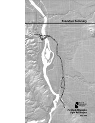
<strong>Public</strong> <strong>Art</strong> <strong>for</strong> <strong>the</strong> <strong>TriMet</strong> <strong>Portland</strong>-<strong>Milwaukie</strong> <strong>Light</strong> <strong>Rail</strong> <strong>Project</strong><strong>Portland</strong>, ORCALL SUMMARY<strong>TriMet</strong> invites qualified artists to apply <strong>for</strong> public art commissions <strong>for</strong> <strong>the</strong> <strong>Portland</strong>-<strong>Milwaukie</strong> <strong>Light</strong> <strong>Rail</strong><strong>Project</strong>. Up to seven (7) professional, established artists/artist teams will be selected to create majorworks <strong>for</strong> new light rail stations, adjacent station areas and at o<strong>the</strong>r significant locations along <strong>the</strong>alignment. Emerging public artists from <strong>the</strong> Pacific Northwest are also encouraged to apply to be shortlisted <strong>for</strong> future additional opportunities. Applications that do not meet <strong>the</strong>se criteria will not be reviewed.A budget of over $3,000,000 has been established <strong>for</strong> public art commissions on <strong>the</strong> project.TRIMET PUBLIC ART PROGRAMIn 1992, <strong>TriMet</strong> initiated <strong>the</strong> <strong>Public</strong> <strong>Art</strong> Program with <strong>the</strong> Westside extension of <strong>the</strong> MAX Blue Line. Theagency <strong>for</strong>malized its commitment to art in 1997 by establishing a policy to integrate public art into allnew, large-scale capital projects. <strong>Project</strong> specific art programs are funded at 1.5% of eligible project costsand guided by volunteer art advisory committees comprised of artists, arts professionals and communitymembers. Since its inception, works by over 175 artists have been added to <strong>the</strong> expanding bus and lightrail system.The goal of <strong>TriMet</strong>’s <strong>Public</strong> <strong>Art</strong> Program is to promote increased transit usage and community pride byintegrating permanent and temporary art work into <strong>the</strong> public transit system, which celebrate <strong>the</strong>contribution of public transportation and recognize <strong>the</strong> cultural richness in <strong>the</strong> region.PORTLAND-MILWAUKIE LIGHT RAIL PROJECTThe quality of life in <strong>the</strong> <strong>Portland</strong> region is <strong>the</strong> result of visionary long-term urban planning. By connectingland use and transportation, <strong>the</strong> <strong>Portland</strong> region has become a national model <strong>for</strong> maintaining andcreating vibrant communities. Greater <strong>Portland</strong> is expected to experience significant growth during <strong>the</strong>next two decades and <strong>the</strong> <strong>Portland</strong>-<strong>Milwaukie</strong> <strong>Light</strong> <strong>Rail</strong> (PMLR) <strong>Project</strong> is a vital transportation link in <strong>the</strong>region’s roadmap <strong>for</strong> continued growth management and building livable communities <strong>for</strong> futuregenerations.The new 7.3-mile PMLR line will have 10 stations and approximately 1,400 Park & Ride spaces.Extending from downtown <strong>Portland</strong> through inner SE <strong>Portland</strong> to <strong>the</strong> city of <strong>Milwaukie</strong> and Oak Grove inunincorporated Clackamas County, <strong>the</strong> alignment will run primarily at grade (i.e., street level). It includesa new bridge across <strong>the</strong> Willamette River and numerous elevated structures that cross over o<strong>the</strong>r bodiesof water, roads and freight rail lines. The project is partially federally funded.While <strong>the</strong> primary goal of <strong>the</strong> project is to provide efficient and sustainable transit options, it also presentsopportunities to make related improvements and add significant design features that connectneighborhoods, encourage pedestrian activity and bicycle use, and create engaging public spaces wherepeople want to be.
Design of <strong>the</strong> project is currently 30% complete. Final Design is anticipated to begin in fall 2010 and willcontinue through early 2012. Construction of <strong>the</strong> alignment is estimated to begin in summer 2012,however <strong>the</strong> building of <strong>the</strong> Willamette River Bridge, a new multi-modal transit bridge that accommodatesbicycles and pedestrians as well as light rail vehicles and buses, but not private vehicles, is scheduled tobegin in 2011. The new light rail MAX line is projected to open in 2015.Applicants are strongly encouraged to view <strong>the</strong> Conceptual Design Report and visual simulations, as wellas o<strong>the</strong>r extensive project materials available online at: trimet.org/pm.PUBLIC ART OPPORTUNITIES<strong>TriMet</strong> will continue its commitment to public art with <strong>the</strong> <strong>Portland</strong>-<strong>Milwaukie</strong> <strong>Light</strong> <strong>Rail</strong> <strong>Project</strong> working incollaboration with project partners, <strong>the</strong> Regional <strong>Art</strong>s and Culture Council, <strong>the</strong> Clackamas County <strong>Art</strong>sAlliance and <strong>the</strong> communities along <strong>the</strong> alignment.Station plat<strong>for</strong>m artwork will address <strong>the</strong> more intimate experience of patrons with site-specific imagery onshelter columns and on neighborhood “story boards” at each station, in a separate, but parallel ef<strong>for</strong>t thatwill coordinate with station area artwork.Significant public art opportunities exist at <strong>the</strong> following locations:Clinton Street StationOn <strong>the</strong> site of a <strong>for</strong>mer fruit-tree grove, <strong>the</strong> area immediately surrounding <strong>the</strong> new Clinton Street station islargely comprised of industrial/commercial uses and bisected by <strong>the</strong> Union Pacific <strong>Rail</strong>road, with <strong>the</strong>Hos<strong>for</strong>d-Abernethy residential neighborhoods extending to <strong>the</strong> north and <strong>the</strong> east, and <strong>the</strong> Brooklynneighborhood to <strong>the</strong> south of <strong>the</strong> station and Powell Boulevard. The new station will present opportunitiesto help connect <strong>the</strong>se active, urban, inner sou<strong>the</strong>ast neighborhoods. The station is located near <strong>the</strong>crossroads of three major arterials, but will have little visibility from <strong>the</strong>se streets, and is also immediatelyadjacent to <strong>the</strong> existing Union Pacific <strong>Rail</strong>road.In this very dynamic location, <strong>the</strong>re is an opportunity <strong>for</strong> several illuminated, large-scale, vertical works toprovide a strong visual connection to <strong>the</strong> station, as well as enhancements to a proposed new pedestrianbridge south of <strong>the</strong> station. Works that reference <strong>the</strong> past and future of <strong>the</strong> site using an innovativecombination of old industrial and new century materials may be desirable.SE 17 th Avenue CorridorThis corridor is characterized by <strong>the</strong> Brooklyn neighborhood’s residential and commercial properties to<strong>the</strong> west of <strong>the</strong> alignment and an industrial “sanctuary” to <strong>the</strong> east. A new pedestrian bridge east of <strong>the</strong>Rhine Street station will provide an improved connection in <strong>the</strong> neighborhood, replacing an existing onethat spans <strong>the</strong> Brooklyn <strong>Rail</strong> Yard. The Holgate Boulevard station area has similar characteristics to thoseof <strong>the</strong> Rhine Street Station, but is situated at a gateway location at <strong>the</strong> sou<strong>the</strong>ast corner of <strong>the</strong> Brooklynneighborhood’s residential core, providing east/west connections through this area. Properties east of <strong>the</strong>Holgate Boulevard station include <strong>TriMet</strong>’s bus staging area and maintenance facility.The opportunity exists <strong>for</strong> a series of sequential works that interact with, or are part of, <strong>the</strong> green streetenhancements along SE 17 th Avenue, such as topiaries, or organic ephemeral works. An illuminatedvertical beacon or landmark could assist with way-finding in <strong>the</strong> Rhine Street station area, since <strong>the</strong> viewof <strong>the</strong> station plat<strong>for</strong>m from <strong>the</strong> pedestrian bridge (and vice versa) may be partially obscured. Thepedestrian bridge also presents an opportunity <strong>for</strong> integrated art.
Bybee Boulevard StationThe Bybee Boulevard station area is largely characterized by <strong>the</strong> verdant landscape created byWestmoreland Park, Eastmoreland Golf Course, Crystal Springs Rhododendron Garden and <strong>the</strong> maturetrees that line McLoughlin Boulevard. Reed College is approximately a half-mile nor<strong>the</strong>ast of <strong>the</strong> station.The Willamette River, Oaks Bottom Wildlife Refuge and <strong>the</strong> Springwater Corridor multi-use trail are duewest of <strong>the</strong> station. In this location <strong>the</strong> plat<strong>for</strong>m is below <strong>the</strong> Bybee Boulevard overpass, which is a newerstructure that reflects <strong>the</strong> historic architecture of <strong>the</strong> original bridge. Access to <strong>the</strong> plat<strong>for</strong>m will be viastairwells and elevators on each side of <strong>the</strong> overpass. A gated enclosure <strong>for</strong> long-term bicycle parking at<strong>the</strong> plat<strong>for</strong>m level will support connections by bicycle.Numerous opportunities exist at this station <strong>for</strong> works of a highly-crafted, human-scale that engagepatrons in an introspective manner and <strong>the</strong>matically link to <strong>the</strong> natural setting or watershed restoration.Designs <strong>for</strong> small scale sculptures on <strong>the</strong> plat<strong>for</strong>m, plat<strong>for</strong>m paving inserts and elevator glass treatmentswill be closely coordinated with station plat<strong>for</strong>m artwork.Tacoma Street StationImbued with a long history of industrial uses dating back to <strong>the</strong> mid 1880s, <strong>the</strong> Tacoma Street station areais mostly comprised of industrial and commercial uses, with residences nearby. The Eastmoreland GolfCourse and neighborhood extend north of <strong>the</strong> station, <strong>the</strong> Westmoreland and Sellwood neighborhoods sitacross McLoughlin Boulevard to <strong>the</strong> west, and <strong>the</strong> Ardenwald-Johnson Creek neighborhood extends to<strong>the</strong> east. Johnson Creek flows through <strong>the</strong> site and runs just north of <strong>the</strong> future station plat<strong>for</strong>m. Thecreek area will be enhanced with riparian vegetation that can be viewed from <strong>the</strong> station plat<strong>for</strong>m, andwater quality impacts of <strong>the</strong> creek crossing will be minimized through storm water management design.A Park & Ride facility is located south of <strong>the</strong> station plat<strong>for</strong>m and north of <strong>the</strong> county line between <strong>the</strong>cities of <strong>Portland</strong> and <strong>Milwaukie</strong>.<strong>Public</strong> art at this location should celebrate and streng<strong>the</strong>n <strong>the</strong> connection to Johnson Creek, as well aseducate <strong>the</strong> public about <strong>the</strong> watershed. The potential exists to site numerous small scale sculptures,such as those that support bird or bat habitat, throughout <strong>the</strong> transitional zones of <strong>the</strong> site. The Park &Ride provides an opportunity to consider limited exterior screening of <strong>the</strong> structure. Enhanced interiorway-finding graphics could offer an additional way to fur<strong>the</strong>r connect patrons with <strong>the</strong> creek.Downtown <strong>Milwaukie</strong> – Lake Rd StationThe station will be <strong>the</strong> sou<strong>the</strong>rn anchor to Main Street in <strong>Milwaukie</strong>’s downtown, a classic small townenvironment that includes historic buildings, active businesses and a growing number of residents. Thestation is surrounded by established residential neighborhoods, Kellogg Creek and Riverfront Park on <strong>the</strong>Willamette River. The light rail alignment through this segment runs adjacent to <strong>the</strong> east side of <strong>the</strong> freightrailroad, which sits between downtown <strong>Milwaukie</strong> and <strong>the</strong> Historic <strong>Milwaukie</strong> and Lake Roadneighborhoods. This presents some unusual opportunities and challenges since <strong>the</strong> light rail plat<strong>for</strong>ms willbe adjacent to freight tracks on one side and to a small triangular site of developable land on <strong>the</strong> o<strong>the</strong>r.The freight tracks also create a barrier between <strong>the</strong> plat<strong>for</strong>m area and <strong>the</strong> adjacent land and activity to <strong>the</strong>west, which has been identified as a future plaza in <strong>the</strong> South Downtown plan. Improvements made by<strong>the</strong> project will be consistent with <strong>the</strong> guidelines and principles in <strong>Milwaukie</strong>’s Downtown Plan, <strong>Public</strong>Area Requirements and Downtown Design Guidelines. Additionally <strong>the</strong> project design will be coordinatedwith <strong>the</strong> City’s ongoing work to refine <strong>the</strong> plans <strong>for</strong> <strong>the</strong> South Downtown and <strong>the</strong> restoration of KelloggCreek.<strong>Art</strong>ists interested in this very complex site should be prepared to honor <strong>the</strong> historic character of downtown<strong>Milwaukie</strong> while celebrating its current revitalization. Opportunities exist to collaborate on <strong>the</strong> station