JeppView : LOWK (16 charts) - VirtuAliRoma
JeppView : LOWK (16 charts) - VirtuAliRoma
JeppView : LOWK (16 charts) - VirtuAliRoma

You also want an ePaper? Increase the reach of your titles
YUMPU automatically turns print PDFs into web optimized ePapers that Google loves.
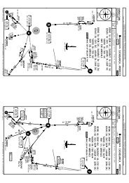
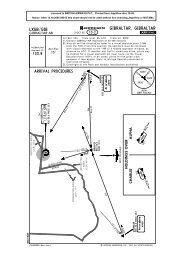
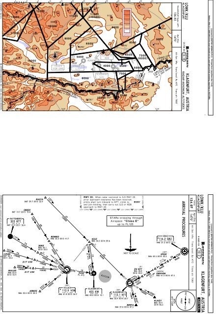
5 0 510 15 20 2530 35 40455055CHANGES: Sectors.| JEPPESEN SANDERSON, INC., 2005. ALL RIGHTS RESERVED.47-007336'46-3010092'15000D50115006952'5381'6732'D40100001200010000D30VILLACHVOR DME8000D20VIENNA LOVV FIR5000KLAGENFURTLctr900011000(10500)KLAGENFURTNDBKLAGENFURT300^270^240^KLAGENFURTLctr210^330^0^180^110009000700050003000CONTOURINTERVALS030^150^060^120^D107500(6000)7041'5174'6309'5757'7037'KLAGENFURT6972'VOR DME6329'9039'5226'8783' 8990'7008'7343'5561'80006864'10000 5427'5361'9397'8393'8488'5109'13-30 14-00 14-30 15-00MILAN LIMMFIR (G)9154'ITALYSLO VENIA7546'ITALY8005'6923'7625'AUSTRIA7037'7211'8009'6285'6040'7123'110003530'LJUBLJANA LJLAFIR/CTA (C/D/E)(up to 2500' AGL(G))5554'3117'(G)4390'5853'65003451'6037'6207'3574'5125'400095007861' 7175'5095'55007500650085005000AUSTRIASLOVENIA3458'90007113'LJUBLJANA LJLAFIR/CTA (C/D/E)(up to 2500' AGL(G))D206955'(G)VIENNA LOVVFIR*KLAGENFURT Radar (APP)126.82Apt Elev1470'Alt Set: hPa Trans level: By ATC Trans alt: 7000'JEPPESEN25 FEB 05KLAGENFURT 10-1R RADAR MINIMUM ALTITUDES<strong>LOWK</strong>/KLUKLAGENFURT, AUSTRIALicensed to BRITISH AIRWAYS PLC, . Printed from <strong>JeppView</strong> disc 13-05.Notice: After 21.7.2005 0901Z this chart should not be used without first checking <strong>JeppView</strong> or NOTAMs.CHANGES: Lost communication procedure added. | JEPPESEN SANDERSON, INC., 2002, 2003. ALL RIGHTS RESERVED.RTTRATTENBERG303 RTTN47 25.9 E011 56.4105^ 75LIZUM N47 06.9E011 45.4OBEDIN47 19.7 E013 19.8117^15000MALUGN46 42.4E012 35.9146^281500075 D171500010000089^RASTAN47 29.7 E013 22.9D17 VIWMIKEN46 50.1E013 33.3171000037 171500010000055^137^17D1710000136^R297^R285^R269^R326^100003<strong>16</strong>^R236^4712000ROMEON46 56.2 E013 41.710000096^(IAF)VILLACHDVIW112.9 VIWN46 41.8 E013 54.9RWY 28: When radar vectored to ILS RWY 28prior approach clearance has been received,pilots shall turn inbound to KFT, climb to 8500'and join holding, then carry out ILS or NDBapproach to RWY 28.LOST COMMS LOST COMMS LOST COMMS LOST COMMS LOST COMMSLOST COMMS040^138500By ATC<strong>16</strong>9^By ATC158500KILON46 54.5 E014 09.6DKWKLAGENFURT405 KW258500N46 40.0 E014 13.1STARs crossing throughAirspace "Class E"up to FL125(IAF)KFT113.1 KFTD KLAGENFURTN46 35.9 E014 33.7NOT TO SCALE(IF)D5 KFTD17 VIW N46 38.4E014 40.0ARNOSN46 32.5 E013 34.28500R317^911000R<strong>16</strong>2^8500BERTAN46 27.0 E014 37.5R118^342^5R058^4000LOST COMMS101000065000D11298^GRZGRAZD1<strong>16</strong>.2 GRZN46 57.3 E015 27.0SPEIKN46 43.5 E014 52.54(IAF)D158000[GRIFN]GRIFFENN46 41.5 E014 47.5KLAGYN46 30.9E014 46.5MSAKFT VOR238^289000ARRIVAL PROCEDURES9900'090^ 270^8700'*ATIS124.07 1470'Apt ElevAlt Set: hPa Trans level: By ATC Trans alt: 7000'KLAGENFURT<strong>LOWK</strong>/KLU10-28 AUG 03.ARRIVAL.JEPPESENKLAGENFURT, AUSTRIALicensed to BRITISH AIRWAYS PLC, . Printed from <strong>JeppView</strong> disc 13-05.Notice: After 21.7.2005 0901Z this chart should not be used without first checking <strong>JeppView</strong> or NOTAMs.
| JEPPESEN SANDERSON, INC., 2002. ALL RIGHTS RESERVED.<strong>16</strong>2^10 2311000D9<strong>LOWK</strong>/KLU10-3KLAGENFURTTrans level: By ATC Trans alt: 7000' 1. Due to high terrain inthe vicinity of airport and along departure track it is absolutelyApt Elev necessary to observe the required climb gradients. 2.Execute turns1470' with a bank angle of at least 20^. 3. For noise abatement reasonsaircraft should use runway 10 whenever possible. 4. An accelerationsegment according to PANS-OPS is not provided due tolimited airspace in the vicinity of airport.At or above3000'KLAGENFURT, AUSTRIAMSAKFT VOR.SID.SIDs crossing throughAirspace "Class E"up to FL125DOL 1KALTERNATE SID KFT 1XCHANGES: Climb gradients; new format.8700'090^ 270^9900'JEPPESEN22 NOV 02 .Eff.28.Nov.KLAGENFURTD 113.1 KFTN46 35.9 E014 33.7These SIDs require minimum climb gradientsofDOL 1F352' per nm (5.8%) up to 11000'.DOL 1K5<strong>16</strong>' per nm (8.5%) up to 11000'.Gnd speed-KT 75 100 150 200 250 300352' per nm 441 587 881 1175 1468 17625<strong>16</strong>' per nm 646 861 1291 1722 2152 2582SID RWYROUTINGDOL 1F 28285^ track to KW, turn LEFT to KFT, turn RIGHT, intercept KFTR-<strong>16</strong>2 via BERTA to DOL.10 105^ track to KFT, turn RIGHT, intercept KFT R-<strong>16</strong>2 via BERTAto DOL.R343^089^21R269^4285^105^9R285^KLAGENFURT405 KWN46 40.0 E014 13.1KFTBERTAN46 27.0 E014 37.5DDOLDOLSKO112.7 DOLN46 05.0 E014 46.7DOL 1FDOL 1KLicensed to BRITISH AIRWAYS PLC, . Printed from <strong>JeppView</strong> disc 13-05.Notice: After 21.7.2005 0901Z this chart should not be used without first checking <strong>JeppView</strong> or NOTAMs.KWDOLSKO ONE FOXTROT (DOL 1F)DOLSKO ONE KILO (DOL 1K)RWYS 28, 10 DEPARTURESSPEED: MAX 205 KT BELOW FL100NOT TO SCALEDOL 1FAt or above8000'DOL 1KAt or above6000'At or above11000'CHANGES: New format.| JEPPESEN SANDERSON, INC., 2002. ALL RIGHTS RESERVED.At or above3000'GRZ 1KALTERNATE SID KFT 1XKFT 1XSIDs crossing throughAirspace "Class E"up to FL125405 KWKLAGENFURTN46 40.0 E014 13.1089^These SIDs require minimum climb gradientsofGRZ 1F334' per nm (5.5%) up to 3000'.GRZ 1KGnd speed-KT 75 100 150 200 250 300334' per nm (5.5%) up to 8000'.334' per nm 418 557 835 1114 1392 <strong>16</strong>71KFT 1X243' per nm (4.0%) up to 8500'.243' per nm 304 405 608 810 1013 1215SIDGRZ 1FRWY28ROUTING285^ track to KW, turn LEFT to KFT, turn LEFT, intercept KFT104285^21105^GRZ 1FGRZ 1K, KFT 1X9KFTKLAGENFURTD113.1 KFTN46 35.9 E014 33.7GRZ 1FAt or above5800'GRZ 1KAt or above4400'KFT 1XAt or above3700'On returnenter holdingat or above8500'R285^R269^8500R-058 to GRZ.105^ track to KFT, turn LEFT, intercept KFT R-058 to GRZ.24105^ track to KFT, turn LEFT, intercept KFT R-058, atLEFT to KFT and enter holding at or above 8500'.KFT 1X6000' turnKFT 1XTurn at6000'D11 KFTAt or above8000'GRAZDGRZ1<strong>16</strong>.2 N46 57.3 E015 27.0NOT TO SCALE9000GRZ 1F, 1KSPEED: MAX 205 KT BELOW FL100GRAZ ONE FOXTROT (GRZ 1F)GRAZ ONE KILO (GRZ 1K)KLAGENFURT ONE X-RAY (KFT 1X)RWYS 28, 10 DEPARTURES238^058^12 31 R238^MSAKFT VORApt Elev1470'necessary to observe the required climb gradients. 2.Execute turnswith a bank angle of at least 20^. 3. For noise abatement reasonsaircraft should use runway 10 whenever possible. 4. An accelerationsegment according to PANS-OPS is not provided due tolimited airspace in the vicinity of airport.9900'090^ 270^8700'Trans level: By ATC Trans alt: 7000' 1. Due to high terrain inthe vicinity of airport and along departure track it is absolutelyKLAGENFURT22 NOV 02<strong>LOWK</strong>/KLU10-3A.Eff.28.Nov..SID.JEPPESENKLAGENFURT, AUSTRIALicensed to BRITISH AIRWAYS PLC, . Printed from <strong>JeppView</strong> disc 13-05.Notice: After 21.7.2005 0901Z this chart should not be used without first checking <strong>JeppView</strong> or NOTAMs.
| JEPPESEN SANDERSON, INC., 2002. ALL RIGHTS RESERVED.170^317^D25<strong>LOWK</strong>/KLUKLAGENFURTTrans level: By ATC Trans alt: 7000'10-3BKLAGENFURT, AUSTRIA1. Due to high terrain inthe vicinity of airport and along departure track it is absolutelyApt Elev necessary to observe the required climb gradients. 2.Execute turns1470' with a bank angle of at least 20^. 3. For noise abatement reasonsaircraft should use runway 10 whenever possible. 4. An accelerationsegment according to PANS-OPS is not provided due tolimited airspace in the vicinity of airport.[RAST1F][RAST1K]MSAKFT VOR.SID.SIDs crossing throughAirspace "Class E"up to FL125At or above3000'ALTERNATE SIDRASTA 1YCHANGES: New format.8700'090^ 270^9900'22 NOV 02JEPPESENRASTA ONE FOXTROT (RASTA 1F)RASTA ONE KILO (RASTA 1K).Eff.28.Nov.RWYS 28, 10 DEPARTURESMAX 205 KT BELOW FL100NOT TO SCALEKLAGENFURT405 KWN46 40.0 E014 13.1These SIDs require minimum climb gradientsof395' per nm (6.5%) up to 5000'.Gnd speed-KT 75 100 150 200 250 300395' per nm 494 658 987 1317 <strong>16</strong>46 1975334' per nm 418 557 835 1114 1392 <strong>16</strong>71280' per nm 349 466 699 932 1<strong>16</strong>5 1398KLAGENFURT313 KIN46 38.0 E014 22.9SID RWYROUTING28KFTKLAGENFURTD 113.1 KFTN46 35.9 E014 33.7RASTA 1K 10 105^ track to KFT, turn LEFT, intercept KFT R-317 to RASTA.13RASTA 1F4285^105^9RASTA 1KR285^287^9350^17N46 45.4E014 21.4KI29 181200012Licensed to BRITISH AIRWAYS PLC, . Printed from <strong>JeppView</strong> disc 13-05.Notice: After 21.7.2005 0901Z this chart should not be used without first checking <strong>JeppView</strong> or NOTAMs.SPEED:RASTAN47 29.7 E013 22.9KILON46 54.5E014 09.6At or above10000'D43 KFTAt or above12000'KWRASTA 1F334' per nm (5.5%) up to 5000', thereafter280' per nm (4.6%).RASTA 1KRASTA 1FRASTA 1FAt or above5000'At or above5000'285^ track to KW, turn LEFT to KI, turn LEFT, intercept 350^ bearingfrom KI, intercept KFT R-317 to RASTA.| JEPPESEN SANDERSON, INC., 2002. ALL RIGHTS RESERVED.317^170^D25<strong>LOWK</strong>/KLUKLAGENFURTApt Elev1470'Trans level: By ATC Trans alt: 7000'10-3CKLAGENFURT, AUSTRIA1. Due to high terrain inthe vicinity of airport and along departure track it is absolutelynecessary to observe the required climb gradients. 2.Execute turnswith a bank angle of at least 20^. 3. For noise abatement reasonsaircraft should use runway 10 whenever possible. 4. An accelerationsegment according to PANS-OPS is not provided due tolimited airspace in the vicinity of airport.[RAST1X][RAST1Y].SID.SIDs crossing throughAirspace "Class E"up to FL125OMRASTA 1XCHANGES: New format.22hdg15 350^RASTA 1WRASTAN47 29.7E013 22.9D43 KFT[RAST1W]MSAKFT VORRASTA 1WAt or above3800'RASTA 1WAt or above3000'8700'090^ 270^9900'22 NOV 02JEPPESEN.Eff.28.Nov.RWYS 28, 10 DEPARTURESMAX 205 KT BELOW FL100KILON46 54.5 E014 09.6NOT TO SCALEKLAGENFURT405 KWN46 40.0 E014 13.1These SIDs require minimum climb gradientsofRASTA 1W498' per nm (8.2%) up to10000'.RASTA 1X395' per nm (6.5%) up to 10000'.RASTA 1Y334' per nm (5.5%) up to 5000'.SID RWYROUTING28RASTA 1WRASTA 1X10KFTKLAGENFURTD 113.1 KFTN46 35.9 E014 33.7Gnd speed-KT 75 100 150 200 250 300489' per nm 623 830 1246 <strong>16</strong>61 2076 2491395' per nm 494 658 987 1317 <strong>16</strong>46 1975334' per nm 418 557 835 1114 1392 <strong>16</strong>71RASTA 1Y 28 285^ track to KW, turn LEFT to KFT, turn LEFT, intercept KFT R-317to RASTA.089^21RASTA 1YR269^44285^ 105^350^29287^At or above12000'29 1812000Licensed to BRITISH AIRWAYS PLC, . Printed from <strong>JeppView</strong> disc 13-05.Notice: After 21.7.2005 0901Z this chart should not be used without first checking <strong>JeppView</strong> or NOTAMs.RASTA ONE WHISKEY (RASTA 1W)RASTA ONE X-RAY (RASTA 1X)RASTA ONE YANKEE (RASTA 1Y)SPEED:At or above10000'KW285^ track to KW, turn RIGHT, intercept 350^ bearing from KW toKILO, intercept KFT R-317 to RASTA.105^ track to OM, turn LEFT, 350^ heading, intercept KFT R-317 toRASTA.
DCHANGES: New format.| JEPPESEN SANDERSON, INC., 2002. ALL RIGHTS RESERVED.RTTRATTENBERG303 RTTN47 25.9 E011 56.47515000MIKEN46 50.1 E013 33.3At or above15000'SIDs crossing throughAirspace "Class E"up to FL125D17VILLACHDVIW112.9 N46 41.8 E013 54.9297^At or above10000'KLAGENFURTN46 40.0 E014 13.1RTT 1FAt or above3800'RTT 1KAt or above7000'277^These SIDs require minimum climb gradientsofRTT 1FGnd speed-KT 75 100 150 200 250 300498' per nm (8.2%) up to 10000', thereafter 498' per nm 623 830 1246 <strong>16</strong>61 2076 2491304' per nm (5.0%).304' per nm 380 506 760 1013 1266 1519RTT 1K286' per nm (4.7%) up to 10000'.286' per nm 357 476 714 952 1190 1428SID RWYROUTINGRTT 1FALTERNATE SID VIW 1Y28 285^ track to KW, turn LEFT, 277^ bearing to VIW, turn RIGHT,VIW R-297 via MIKE to RTT.RTT 1K 10 105^ track to KFT, turn LEFT via KW to VIW, turn RIGHT, VIW R-297via MIKE to RTT.R097^13405 KW285^4 9RTT 1F105^NOT TO SCALE21RTT 1KKFTKLAGENFURTD113.1 KFTN46 35.9 E014 33.7At or above4000'R285^SPEED:RWYS 28, 10 DEPARTURESMAX 205 KT BELOW FL100269^RATTENBERG ONE FOXTROT (RTT 1F)RATTENBERG ONE KILO (RTT 1K)MSAKFT VORTrans level: By ATC Trans alt: 7000' 1. Due to high terrain inthe vicinity of airport and along departure track it is absolutelyApt Elev necessary to observe the required climb gradients. 2.Execute turns1470' with a bank angle of at least 20^. 3. For noise abatement reasonsaircraft should use runway 10 whenever possible. 4. An accelerationsegment according to PANS-OPS is not provided due tolimited airspace in the vicinity of airport.9900'090^ 270^8700'KLAGENFURT22 NOV 02<strong>LOWK</strong>/KLU10-3D.Eff.28.Nov..SID.JEPPESENKLAGENFURT, AUSTRIALicensed to BRITISH AIRWAYS PLC, . Printed from <strong>JeppView</strong> disc 13-05.Notice: After 21.7.2005 0901Z this chart should not be used without first checking <strong>JeppView</strong> or NOTAMs.CHANGES: New format.| JEPPESEN SANDERSON, INC., 2002. ALL RIGHTS RESERVED.ERKIRN47 32.3E012 00.576DETSAN46 48.2E012 <strong>16</strong>.9At or above15000'1751 17D17 VIWD17 VIWAt or above15000'ARNOSN46 32.5 E013 34.2At or aboveFL150D17136^ 10000302^275^3<strong>16</strong>^236^170^12R097^ISTRIN46 29.9E013 57.6VILLACHDVIW112.9 N46 41.8 E013 54.9At or above11000'At or above10000'KLAGENFURTN46 40.0 E014 13.1VIW 1FAt or above3800'VIW 1XAt or above7000'VIW 1YTurn LEFTto KFTThese SIDs require minimum climb gradientsAt or aboveof3000'VIW 1F498' per nm (8.2%) up to 10000'.Gnd speed-KT 75 100 150 200 250 300VIW 1X498' per nm 623 830 1246 <strong>16</strong>61 2076 2491286' per nm (4.7%) up to 10000'.VIW 1Y395' per nm 494 658 987 1317 <strong>16</strong>46 1975334' per nm (5.5%) up to 3000'.334' per nm 418 557 835 1114 1392 <strong>16</strong>71VIW 1Z395' per nm (6.5%) up to 10000'.286' per nm 357 476 714 952 1190 1428SID RWYROUTINGVIW 1FALTERNATE SID VIW 1Y28 285^ track to KW, turn LEFT, 277^ bearing to VIW, join cleared ATSroute.VIW 1X 10 105^ track to KFT, turn LEFT via KW to VIW, join cleared ATS route.VIW 1Y 28 285^ track to KW, turn LEFT to KFT, turn LEFT via KW to VIW, joincleared ATS route.VIW 1Z 10 105^ track to OM, turn LEFT to KW, 277^ bearing to VIW, join clearedATS route.13405 KW277^SIDs crossing throughAirspace "Class E"up to FL125089^4285^VIW 1F, 1Y VIW 1X10⁵^21VIW 1Z4VIW 1YOMNOT TO SCALE15521VIW 1X, 1YSPEED:RWYS 28, 10 DEPARTURESMAX 205 KT BELOW FL100KFTKLAGENFURTD113.1 KFTN46 35.9 E014 33.7R285^R269^VIW 1XAt or above4000'269^VILLACH ONE FOXTROT (VIW 1F)VILLACH ONE X-RAY (VIW 1X)VILLACH ONE YANKEE (VIW 1Y)VILLACH ONE ZULU (VIW 1Z)holding pattern and leave at an altitude sufficent to reach airwayMEA not later than at the indicated DME distance.MSAKFT VORTrans level: By ATC Trans alt: 7000' 1. Due to high terrain inthe vicinity of airport and along departure track it is absolutelynecessary to observe the required climb gradients. 2.Execute turnsApt Elev with a bank angle of at least 20^. 3. For noise abatement reasons1470' aircraft should use runway 10 whenever possible. 4. An accelerationsegment according to PANS-OPS is not provided due tolimited airspace in the vicinity of airport. 5. If necessary join VIW9900'090^ 270^8700'KLAGENFURT22 NOV 02<strong>LOWK</strong>/KLU10-3E.Eff.28.Nov..SID.JEPPESENKLAGENFURT, AUSTRIALicensed to BRITISH AIRWAYS PLC, . Printed from <strong>JeppView</strong> disc 13-05.Notice: After 21.7.2005 0901Z this chart should not be used without first checking <strong>JeppView</strong> or NOTAMs.
CHANGES: Climb gradients; new format.| JEPPESEN SANDERSON, INC., 2002. ALL RIGHTS RESERVED.SIDZAG 1F405 KWKLAGENFURTN46 40.0 E014 13.1At or above3000'089^These SIDs require minimum climb gradientsofZAG 1F352' per nm (5.8%) up to 10000'.ZAG 1K444' per nm (7.3%) up to 10000'.Gnd speed-KT 75 100 150 200 250 300352' per nm 441 587 881 1175 1468 1762444' per nm 554 739 1109 1479 1848 2218RWY28ZAG 1K 104285^21105^ZAG 1F9ZAG 1KKLAGENFURTD113.1 KFTN46 35.9 E014 33.7R285^R269^KFTZAG 1FAt or above8000'ZAG 1KAt or above5200'NOT TO SCALEROUTING285^ track to KW, turn LEFT to KFT, turn RIGHT, KFT R-118 viaKLAGY to ZAG.105^ track to KTF, turn RIGHT, KTF R-118 via KLAGY to ZAG.DSIDs crossing throughAirspace "Class E"up to FL125118^ R299^10KLAGYN46 30.9 E014 46.5At or above10000'7410000SPEED:ZAGREBD113.7 ZAGN45 53.7 E0<strong>16</strong> 18.4RWYS 28, 10 DEPARTURESMAX 205 KT BELOW FL100ZAGREB ONE FOXTROT (ZAG 1F)ZAGREB ONE KILO (ZAG 1K)MSAKFT VORTrans level: By ATC Trans alt: 7000' 1. Due to high terrain inthe vicinity of airport and along departure track it is absolutelynecessary to observe the required climb gradients. 2.Execute turnsApt Elev with a bank angle of at least 20^. 3. For noise abatement reasons1470' aircraft should use runway 10 whenever possible. 4. An accelerationsegment according to PANS-OPS is not provided due tolimited airspace in the vicinity of airport.9900'090^ 270^8700'KLAGENFURT22 NOV 02<strong>LOWK</strong>/KLU10-3F.Eff.28.Nov..SID.JEPPESENKLAGENFURT, AUSTRIALicensed to BRITISH AIRWAYS PLC, . Printed from <strong>JeppView</strong> disc 13-05.Notice: After 21.7.2005 0901Z this chart should not be used without first checking <strong>JeppView</strong> or NOTAMs.JEPPESENApt Elev 1470'11 JUN 04 10-9KLAGENFURTN46 38.6 E014 20.2*ATIS*KLAGENFURT Tower124.07GLIDERSTRIP2329'710mGRASSIFR DEPARTURE PROCEDUREA careful calculation of the take-off parameters and the aircraft climb gradient is essential. In no caseenter a holding pattern below the published minimum holding altitude.| JEPPESEN SANDERSON, INC., 1999, 2004. ALL RIGHTS RESERVED.CBA<strong>16</strong>83'1709'<strong>16</strong>63'1962' 14-20 2225'1742'1522'1598'46-39 1552'46-39Treesup to1549'AIS+METControl TowerTrees Elevup to 1473'1532'ZMB L<strong>16</strong>96'CYTreesup to17<strong>16</strong>'Treesup to1528'02^E<strong>LOWK</strong>/KLUKLAGENFURT, AUSTRIA118.114-19STAND1112, H12122 thru 26, 6627, 28H2, H3PARKING POSITIONSCOORDINATESN46 39.0 E014 19.6N46 38.9 E014 19.6N46 39.0 E014 19.5N46 38.9 E014 19.5N46 38.8 E014 19.5N46 38.8 E014 19.6ARP14-19.446-39ControlTowerAIS+MET46-38.91543'Rwy 28 approved for CAT II/IIIoperations, special aircrew andacft certification required.46-38 Feet 0 1000 2000 3000 4000 5000Parachuting activity.46-38Birds in vicinity of apt.Meters 0 500 1000 15001739'14-1914-2014-2114-2214-21M14-19.5 14-19.6 14-19.7TML46-39TL202<strong>16</strong>6222324252627281112TL10H1H2H346-38.8L 46-38.814-19.4 B 14-19.6 C 14-19.714-22HANGAR146-38.9HANGAR2ADDITIONAL RUNWAY INFORMATIONRWYThreshold10 HIRL (60m) CL (15m) HIALS PAPI (3.5^) RVR 8268' 2520m28 HIRL (60m) CL (15m) ALSF-II SFL TDZRVR10Grass runway281 PAPI (angle 3.0^).1LANDING BEYONDUSABLE LENGTHSGlide SlopeTAKE-OFFWIDTHPREFERENTIAL RUNWAY SYSTEM:To minimize noise, landing on rwy 28 and take-off on rwy 10 shall be performed whenever possible.LOW VISIBILITY PROCEDURESLVP will become effective in two stages in relation to weather conditions:Stage 1: LVP becomes effective when RVR for TDZ is 1200m or less and/or cloudbase/vertical visibility is300' or less. Pilots will be informed either via ATIS or RTF: "LOW VISIBILITY PROCEDURES STAGE ONEIN OPERATION".Stage 2: LVP becomes effective when RVR for TDZ is 600m or less and/or ceiling/vertical visibility is200' or less. "RUNWAY VACATED" is to be reported by the pilot as soon as the acft has left the yellow/green colourcoded section of the exit twy. Pilots will be informed either via ATIS or RTF: "LOWVISIBILITY PROCEDURES CAT II/III STAGE TWO IN OPERATION".ABCD1ApprovedOperatorsHIRL, CL& mult. RVR req125m150mTAKE-OFF1LVP must be in ForceRL, CL& mult. RVR req150m200mRL & CL200m250m& IFR DEPARTURE PROCEDUREAll RwysRCLM (DAY only) RCLM (DAY only)or RL or RL250m300mNIL(DAY only)400m 500mOperators applying U.S. Ops Specs: CL required below 300m; approved guidance system requiredbelow 150m.CHANGES: Lights.8924' 2720m28285^Elev1472'Elev1463'Elev1463'Elev1444'2001' 610m7874' 2400m148'45m82'25m.JAR-OPS.10105^Licensed to BRITISH AIRWAYS PLC, . Printed from <strong>JeppView</strong> disc 13-05.Notice: After 21.7.2005 0901Z this chart should not be used without first checking <strong>JeppView</strong> or NOTAMs.
330^285^CHANGES: See other side.| JEPPESEN SANDERSON, INC., 1999, 2004. ALL RIGHTS RESERVED.PANS OPS1 W/o OEK DME apply LOC MDA(H); RVR 800m, ALS out RVR 1200m.DA(H) CAT A <strong>16</strong>54'(210'), CAT B <strong>16</strong>67'(223').2 3 DA(H) CAT A 1759'(315'), CAT B 1808'(364').DRVR 800m RVR 1200mRVR<strong>16</strong>00mCRVR2000mBRVRRVR550m 1000mRVR RVR600m 1000mRVR RVR800m 1200mRVR1200mARVR1500mSee 19-1 forCIRCLE-TO-LANDwith prescribedflight tracksRVR 1000mDA(H)C:<strong>16</strong>77'(233')DA(H)<strong>16</strong>44'(200') 2 D: 1805' (361') 3FULL ALS out FULLALS out FULL ALS outALS outMDA(H)DA(H) DA(H) C: (374') ABC:D: (531')1818'1975'1900'D: 2030' (456')(586')Not authorizedNorth of airportMissed Apch climb Missed Apch climb Missed Apch climbgradient mim 4.0% gradient mim 3.0% gradient mim 2.5%.JAR-OPS.STRAIGHT-IN LANDING RWY 28 CIRCLE-TO-LANDILS 1LOC (GS out)377 485 539 647 755 8625.2%MAP at LMM/D1.4 OEKILS GS orLOC Descent GradientGnd speed-Kts3.00^PAPI PAPI70 90 100 120 140 <strong>16</strong>0ALSF-II285^ D5.0OEKIn case of GP or OEK DME inoperative climb on 285^ up to 2600', then turn LEFT inbound KI Lctr and continuemissed apch as described above. Accelerate after completion of the missed apch turn and homing KI Lctr.RWY 28 2.44.2 1.11.3MISSED APCH: Climb on 285^ to D5.0 OEK, then turn LEFT to KI Lctr. Continue climb on 105^to OM and join procedure turn not below 4000'. Continue climb to 8500' via KI Lctr. Aftercompleting Baseturn proceed inbound to VOR and join holding at 8500'.1444'TCH 57'LOCGS 1900'285^2700'D8.0OEK6000' 5100'105^105^GS 2700'4000'330^ 285^KW Lctr8500'105^D1.4 OEK D3.8 OEK5 054000LMM OM14-10 14-20 7041' 14-30 14-403000AA4000MVORD9.1 OEK8500'5000500020003000LO(D)-293000400030002000200020002000KLAGENFURTD 113.1 KFT3000K F TD9.1 OEK200046-35PROCEDURE TURN:D 43117'3192'2209'2279'R EMA I N. 7Avoid City ofKlagenfurtbelow 3000' AGL285^ 110.1 OEK D8.0OEKILS DMEO E K285^K F T3028'2490'239^WI T H IN060^8500From KILO orafter Holding105^285^105^D3.8 OEK2201'OM059^D5.0OEK330^349^2000200046-4012546'2024'2000KLAGENFURTK 313 KID1.4 OEKIMSA KFT VOR85002785'1 105^ 7.1 5100to KI Lctr9900'3000<strong>16</strong>9^2000090^270^30002000KLAGENFURTK 405 W KWD14.8 KFT3451'20003537'8700'20003574'3980'1. Below 8500' procedure based on MAX IAS 185 KT.2. Intercept localizer not later than overhead VOR.MSA KW LctrAlt Set: hPa Rwy Elev: 52 hPaTrans level: By ATC Trans alt: 7000'BRIEFING STRIP TM055^10,900'Missed Approach - See Below290^OEK110.1LOC124.07 126.82 118.1GSILSOMFinalApch Crs285^ 2700'(1256')DA(H) Apt Elev 1470'Refer toMinimums RWY 1444'9600'8400'180^*ATIS *KLAGENFURT Radar (APP)*KLAGENFURT TowerJEPPESEN<strong>LOWK</strong>/KLUKLAGENFURT, AUSTRIAKLAGENFURT 11 JUN 04 11-1ILS Rwy 28Licensed to BRITISH AIRWAYS PLC, . Printed from <strong>JeppView</strong> disc 13-05.Notice: After 21.7.2005 0901Z this chart should not be used without first checking <strong>JeppView</strong> or NOTAMs.CHANGES: New procedure.| JEPPESEN SANDERSON, INC., 2004. ALL RIGHTS RESERVED.PANS OPS1Radio altimeter and coupled approach required.ACCORDING SPECIAL PERMISSION.JAR-OPS. STRAIGHT-IN LANDING RWY281Gnd speed-Kts 70 90 100 120 140 <strong>16</strong>0GS 3.00^ 377 485 539 647 755 862PAPI PAPIALSF-II285^ D5.0OEKAccelerate after completion of the missed apch turn and homing KI Lctr.RWY 28 2.44.2 1.11.3MISSED APCH: Climb on 285^ to D5.0 OEK, then turn LEFT to KI Lctr. Continue climb on 105^to OM and join procedure turn not below 4000'. Continue climb to 8500' via KI Lctr. Aftercompleting Baseturn proceed inbound to VOR and join holding at 8500'.1444'TCH 57'GS 1900'285^D8.0OEKGS 2700'4000'105^5100'105^6000'D1.4 OEK D3.8 OEKLMM OM46-307041'14-20 14-30 14-40AAMVORD9.1 OEK8500'3000400050005 05The use of this procedurerequires authorization byAustro Control GmbH.For detailed informationand instructions see page11-1B.30004000LO(D)-29D9.1 OEK20003000285^ 110.1 OEK3117'14-10ILS DMEO E K2000KLAGENFURTD 113.1 KFTK F TREM2279'3192'2209'OEK20002000285^2000PROCEDURE TURNAIN WITHIND4.7 K FTD1.4 OEKOMD3.8 OEKD8.0239^3028'2589'Avoid City ofKlagenfurtbelow 3000' AGL:060^8500From KILO orafter Holding059^2300'105^285^105^330^2000349^46-40D5.0OEK20002546'200020002024'8500KLAGENFURT313 K KII2785'MSA KFT VOR<strong>16</strong>9^3451'3000200020009900'2000KLAGENFURT405 KWD14.8 KFTto KI Lctr105^ 7.1 5100090^270^1 MISSED APCH CLIMBGRAD MIM 4.7%2000K W3537'20003574'30003980'8700'1. Below 8500' procedure based on MAX IAS 185 KT.2. Intercept localizer not later than overhead VOR.MSA KW LctrAlt Set: hPa Rwy Elev: 52 hPaTrans level: By ATC Trans alt: 7000'BRIEFING STRIP TM055^10,900'Missed Approach - See Below290^OEK110.1LOC124.07 126.82 118.1GSCAT II ILSOMFinalApch Crs285^ 2700'(1256')Refer toMinimumsApt Elev 1470'RWY 1444'9600'8400'180^*ATIS *KLAGENFURT Radar (APP)*KLAGENFURT TowerKLAGENFURT<strong>16</strong> JAN 04.Eff.22.Jan.<strong>LOWK</strong>/KLUJEPPESEN11-1A 1KLAGENFURT, AUSTRIASpecial CAT II ILS Rwy 28Licensed to BRITISH AIRWAYS PLC, . Printed from <strong>JeppView</strong> disc 13-05.Notice: After 21.7.2005 0901Z this chart should not be used without first checking <strong>JeppView</strong> or NOTAMs.
KLAGENFURT, AUSTRIAKLAGENFURTApt ElevLicensed to BRITISH AIRWAYS PLC, . Printed from <strong>JeppView</strong> disc 13-05.Notice: After 21.7.2005 0901Z this chart should not be used without first checking <strong>JeppView</strong> or NOTAMs.1470'<strong>16</strong> JAN 0411-1B.Eff.22.Jan.<strong>LOWK</strong>/KLUSPECIAL NOTESSPECIAL CAT II/III ILS DME PROCEDURE RWY 28 GUIDELINES1. Purpose and ScopeAs this CAT II/III ILS DME approach procedurecontains a NON-ICAO STANDARD missed approach(higher than normal missed approach climb gradient),special authorization by Austro Control GmbH isrequired for each operator and acft type.This is to prove the performance of the acft to, i.e.:have sufficient climb capability during a criticalengine-out missed approach.JEPPESEN2. Missed Approach RequirementsIt is necessary to prove a climb gradient of 4.7% forthe critical engine-out climb capability at 4000' MSLin the approach climb configuration (whereapplicable) under the following conditions:- at ISA +10^C (i.e. OAT +20^C at 4000' MSL)- at ISA -10^C (i.e. OAT 0^C at 4000' MSL) andthe ANTI-ICE equipment ON .3. ApplicationOnly operators of multi-engine acft shall apply forsuch a permission.The application shall contain:- acft and engine type- the maximum permissible landing weight forthat type of approach- minimum autopilot cut out height or autolandcapability- instrument approach and landing chart (IAL)The following missed approach performance data arerequired for an altitude of 4000' MSL:a) all-engines climb gradient:- IAS- ISA +10^C (i.e. OAT +20^C ),- ISA -10^C (i.e. OAT 0^C)andthe ANTI-ICE equipment ON .b) one-engine inoperative climb gradient:- IAS- ISA +10^C (i.e. OAT +20^C ),- ISA -10^C (i.e. OAT 0^C)andthe ANTI-ICE equipment ON .The relevant performance data shall be submitted ina listed form together with copies of the relevantpages of the Airplane Flight Manual or PerformanceManual. Applications shall be conveyed at least sixweeks prior to the intended operations.Operators shall address their application to:Austro Control GmbHDepartment OperationsSchnirchgasse 11A-1030 VIENNATel: +43 (0)5 1703-7010Fax: +43 (0)5 1703-76CHANGES: New page.| JEPPESEN SANDERSON, INC., 2004. ALL RIGHTS RESERVED.PANS OPS5 05 10BRIEFING STRIP TM300020003000200020002000200020003000105^ 105^D2.0VIW097^2.09000VIW2.0 2.0 2.0 2.0 2.68000 7000 6000 5000 35004000D4.0VIW VIW D6.0VIW D8.0 D10.03000500020002000200020003000300050004000400050004000500040006000MISSED APCH CLIMBGRADIENT MIM 3.1%D11.0KFT105^JEPPESEN<strong>16</strong> JAN 04KLAGENFURT <strong>16</strong>-1.Eff.22.Jan.LctrKW405 105^Minimum AltLctr3500'MDA(H)2800'(1330')(2030')RWYMISSED APCH: Climb to KFT VOR, then turn LEFT and follow R-059KFT (for at least 1 Min) climbing to 6000', then turn LEFT toKFT VOR and hold. Do not enter KFT VOR holding below 8500'.KLAGENFURT, AUSTRIANDB DME Rwy 10Apt Elev1470'1470'9600'MHA8500KW 8400'Lctr10,900'8700'KFTLctr9900'STRAIGHT-IN LANDING RWY 10Missed apch climb gradient mim 3.1%090^270^*ATIS124.07*KLAGENFURT Radar (APP)126.82*KLAGENFURT Tower118.1Alt Set: hPa Rwy Elev: 53 hPa Trans level: By ATC Trans alt: 7000'Below 8500' procedure based on MAX IAS 185 KT.Lctr3500'D11.0KFT3.80.7TO DISPLACED THRESHOLD 4.5 0KFT113.1PAPI PAPIMAP at D11.0 KFT.JAR-OPS.ABMDA(H) 2800'(1330')ALS outRVR 1500mMaxKts100135CIRCLE-TO-LANDNot authorized North of airportMDA(H)2800'(1330')2800'(1330')VIS1500m<strong>16</strong>00mCD180RVR 2000m1852800'(1330')2800'(1330')2400m3600m105^<strong>LOWK</strong>/KLU46-456285'46-4046-352119'VOR NOT USABLEBELOW 8000'FinalApch CrsVILLACHDV 112.9 I VIW W3530'3028'4390'KLAGENFURT405 K W KW2024'3117'2300'2589'Avoid City ofKlagenfurtbelow 3000' AGLMSAMSA14-00 14-10 14-20HIALSRVR 1800mRVR 2000mCHANGES: Printing sequence.| JEPPESEN SANDERSON, INC., 2000, 2004. ALL RIGHTS RESERVED.059^059^4390'3451'MISSED APCH FIXKLAGENFURTD 113.1 KFTK F T2546'3192'3574'RWY 10 1470'055^290^180^Licensed to BRITISH AIRWAYS PLC, . Printed from <strong>JeppView</strong> disc 13-05.Notice: After 21.7.2005 0901Z this chart should not be used without first checking <strong>JeppView</strong> or NOTAMs.
2985'3540'CHANGES: Chart reindexed. Communications. New chart format. | JEPPESEN SANDERSON, INC., 2000. ALL RIGHTS RESERVED.PANS OPSDRVR 1800mRVR 2000mCRVR 1400mSee 19-1 for CIRCLE-TO-LANDwith prescribed flight tracksBRVR 1500mARVR 1200mALS outMDA(H) 2400'(956')Not authorized North of airport.JAR-OPS.STRAIGHT-IN LANDING RWY 28CIRCLE-TO-LANDMAP at KI LctrPAPI PAPI3500'on 285^HIALSRWY 281444'6.30 1.2 7.5OCA(H) RWY 282400'(956')285^273^4000'(2556')273^1 Min6000'(4556')105^5100'(3656')093^057^Start4600' turn at(3156')KW Lctr8500'(7056')330^ 273^105^KI LctrKFT NDB8500'(7056')5 05 10400020005410'5538'14-10 14-20 7041' 14-30 14-40500030003000400040003000400030002000300020002000LO(D)-2930003031'2000200020003192'46-35below 3000' AGL2694'200020 00Avoid City ofKlagenfurt20002352'2 0002589'2000From KILO or 2300'after HoldingKLAGENFURTK 313 I KI273^273^2000285^057^to KI Lctr330^093^349^105^510046-407.1850020002546'2000200020002000KLAGENFURTK 374 F KFT T2785'3451'<strong>16</strong>9^200030002000KLAGENFURT374 KFT3579'2000KLAGENFURTK 405 W KW8500239^059^20003000KLAGENFURTHOLDING46-4520002000400030004006'MSA KFT NDBAlt Set: hPa Rwy Elev: 52 hPa Trans level: By ATC Trans alt: 7000'(5556')Below 8500'(7056') procedure based on MAX IAS 185 KT.9900'Accelerate after completion of the missed apch turn and homing KI Lctr.090^270^MISSED APCH: Climb on 285^ to 3500', then turn LEFT to KI Lctrand continue climb on 093^, cross KFT NDB not below 4600'and in reverse of the let down procedure up to 8500'.8700'BRIEFING STRIP TMMSA KW LctrNDBKFT374124.07 126.82Minimum AltKFT NDBFinalApch Crs273^4000'(2556')MDA(H) Apt Elev 1470'2400'(956') RWY 1444'055^10,900'290^118.19600'8400'*ATIS*KLAGENFURT Radar (APP)*KLAGENFURT Tower180^JEPPESEN<strong>LOWK</strong> KLAGENFURT, AUSTRIA28 JAN 00KLAGENFURT <strong>16</strong>-2NDB Rwy 28Licensed to BRITISH AIRWAYS PLC, . Printed from <strong>JeppView</strong> disc 13-05.Notice: After 21.7.2005 0901Z this chart should not be used without first checking <strong>JeppView</strong> or NOTAMs.20002000200020002000Rwy10MISSED APCH:If visual contact to the apt is lost, climb to MDA(H) and turnRIGHT to KI Lctr, then follow missed apch procedure as described for ILSor NDB apch.Not authorized North of airport20002950'2421'3451'1920'2474'2152'2093'2425'2490'2454'1706'1526'2201'2241'2330'1801'1834'2034'1703'17<strong>16</strong>'1765'1709'1703'2303' 2566'1552'1762' 1739'1453'Klagenfurt2225'1742'1542'2507'2546'2333'2041'1749'2005'2320'2638'1883'Glan2438'2805'1529'2526' 2543'V ISUAL M ANEU VERING AREAGlanfurtVISUALMANEUVERINGPROHIBITEDOM285^ILS240^273^NDBKI LctrGurkDo notovershoot106^KI LctrKW LctrAvoid City ofKlagenfurtbelow 3000' AGL1962'Glan2000Licensed to BRITISH AIRWAYS PLC, . Printed from <strong>JeppView</strong> disc 13-05.Notice: After 21.7.2005 0901Z this chart should not be used without first checking <strong>JeppView</strong> or NOTAMs.<strong>LOWK</strong>Apt Elev 1470'19-1CIRCLE-TO-LAND28 JAN 00JEPPESENWITH PRESCRIBED FLIGHT TRACKSKLAGENFURT, AUSTRIAKLAGENFURT.JAR-OPS.MaxKtsA 100BC135180MDA(H) VIS2750' (1280')1500m2750'(1280')2850' (1380')<strong>16</strong>00m2400mD 185 2850' (1380')3600mCHANGES: New chart.| JEPPESEN SANDERSON, INC., 2000. ALL RIGHTS RESERVED.