Colorado Statewide Forest Resource Assessment
Colorado Statewide Forest Resource Assessment Colorado Statewide Forest Resource Assessment
Map 4 – Colorado Forest Legacy AreasActively and Sustainably Manage Forests• Spatial Analysis – Identify opportunities to focus management assistanceprograms for private forest landowners. 24Map 5 – Colorado Spatial Analysis Project24See Appendix D: Forest Stewardship Spatial Analysis Methodology Report for Colorado, December 2005 at http://csfs.colostate.edu/pages/statewide-forest-assessment.html24
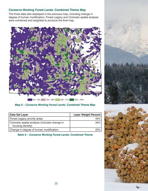
Conserve Working Forest Lands: Combined Theme MapThe three data sets displayed in the previous map, including change indegree of human modifi cation, Forest Legacy and Colorado spatial analysiswere combined and weighted to produce the fi nal map.Map 6 – Conserve Working Forest Lands: Combined Theme MapData Set LayerLayer Weight PercentForest Legacy priority areas 44%Colorado spatial analysis (includes change in34%housing density)Change in degree of human modifi cation 22%Table 6 – Conserve Working Forest Lands: Combined Theme25
- Page 1 and 2: Colorado Statewide ForestResource A
- Page 3: Table of ContentsI. Executive Summa
- Page 6 and 7: II.BackgroundThe Colorado Statewide
- Page 8 and 9: National Guidance for Statewide For
- Page 10 and 11: III. Overview of Colorado’s Fores
- Page 12 and 13: Spruce-Fir 9Spruce-fi r is among th
- Page 14 and 15: Mixed Conifer 14The mixed conifer f
- Page 16 and 17: Oak ShrublandsOak shrublands cover
- Page 18 and 19: Windbreaks, shelterbelts and their
- Page 20 and 21: Owner Spruce-Fir Lodgepole Aspen Mi
- Page 22 and 23: forest management costs per acre ha
- Page 24 and 25: include standard ownership data and
- Page 26 and 27: The second metric is an estimate of
- Page 30 and 31: NATIONAL THEME: Protect Forests fro
- Page 32 and 33: Map 7 - Wildland Fire Susceptibilit
- Page 34 and 35: Map 8 - Wildland Fire Intensity Ind
- Page 36 and 37: ot (CSFS 2001 and 2002). Some insec
- Page 38 and 39: Map 10 - Insect and Disease Mitigat
- Page 40 and 41: is legally mandated, as well as dal
- Page 42 and 43: change, including species extinctio
- Page 44 and 45: transport of materi als that can ad
- Page 46 and 47: Map 15 - Post-Fire Erosion RiskMap
- Page 48 and 49: environment, many homes and other s
- Page 50 and 51: Owner 0.5 mile 1 mile 2 mile TotalU
- Page 52 and 53: Map 18 - Wildland-Urban Interface w
- Page 54 and 55: Map 20 - Wildland-Urban Interface w
- Page 56 and 57: They also are important partners in
- Page 58 and 59: Forest TypeAcres for Wood Products
- Page 60 and 61: of fragmentation to help forest man
- Page 62 and 63: Forest Type Low Moderate High Very
- Page 64 and 65: Map 25 - Important Habitat for Econ
- Page 66 and 67: ACRESImp. Habitat for Econ.Imp. Spe
- Page 68 and 69: Forest Type Low Moderate High Very
- Page 70 and 71: Map 28 - Community Forestry Opportu
- Page 72 and 73: Enhance Public Benefits from Trees
Conserve Working <strong>Forest</strong> Lands: Combined Theme MapThe three data sets displayed in the previous map, including change indegree of human modifi cation, <strong>Forest</strong> Legacy and <strong>Colorado</strong> spatial analysiswere combined and weighted to produce the fi nal map.Map 6 – Conserve Working <strong>Forest</strong> Lands: Combined Theme MapData Set LayerLayer Weight Percent<strong>Forest</strong> Legacy priority areas 44%<strong>Colorado</strong> spatial analysis (includes change in34%housing density)Change in degree of human modifi cation 22%Table 6 – Conserve Working <strong>Forest</strong> Lands: Combined Theme25


