

11MB PDF - Association for Mexican Cave Studies
11MB PDF - Association for Mexican Cave Studies
11MB PDF - Association for Mexican Cave Studies

You also want an ePaper? Increase the reach of your titles
YUMPU automatically turns print PDFs into web optimized ePapers that Google loves.
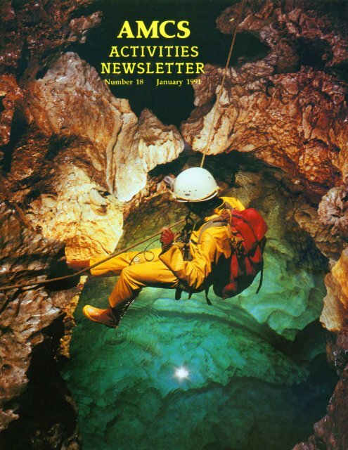
NUMBER 18AMCSACTIVITIESNEWSLETTEREditorPatricia KambesisTranslationsPeter Bosted, Raul Puente, Jorge Riano, Peter SprouseArtwork and GraphicsLinda Heslop, Jerry WallaceJANUARY 1991Publisher<strong>Association</strong> <strong>for</strong> <strong>Mexican</strong> <strong>Cave</strong> <strong>Studies</strong>with assistance from William RussellStaffCarl Anderson, Kris Green, Dave Hughes,Susie Lasko, Bill Mixon, Karen Sotona, Shirley Sotona,Peter Sprouse, Carol VeselyFront CoverRolf Adams at the Swim Gym,Sistema Cuicateco, Oaxaca (Bill Stone)FrontispieceBill Storage at the fifth drop inCueva de Agua Carlota, Oaxaca (Jim Smith)Title PageSan Agustin, Sistema HuautlaOaxaca (Jim Smith)Back CoverBrian Steele at second pitch in Nita Ka,Oaxaca (Jim Smith)EditorialMexico remains on the <strong>for</strong>efront ofworld-class speleologyoffering opportunities to cavers, both local and international,whose commonpursuitis theexploration, study anddocumentationofthe country's many caving areas. This is reflected inthe exploration and project reports submitted to this publication.<strong>Cave</strong>s that have systematically been worked over the yearsstill yield new discoveries. Ongoing explorations in the Purificaci6narea caves delineate the complexity and extensivenessof these systems. The secrets of the deep and extensiveSistema Huautla continue to be revealed through explorationscoupled with scientific investigations. Renewed interest inknown areas due to the availability of updated topographicmaps orothernew in<strong>for</strong>mation, has inspired more than one tripto places that had been worked in the past as evidenced byrecent excursions to Acathin (Puebla) and Yerbabuena (Chiapas).And, even heavily visited areas still offer surprises.Explorations instigated by <strong>Mexican</strong> cavers in the San Franciscoarea (San Luis PotosI) resulted in the discovery of asignificant new cave called Resumidero el Borbo1l6n, noted<strong>for</strong> its 217 meter, in-cave pit. A major extension in Pozo deMontemayor (near Bustamante), makes it northern Mexico'sfirst 500-meter deep cave.Ventures to southern Mexico's remote mountains haveopened up some new, exciting areas. Sistema Cuicateco hasthe potential to be the world's deepest cave; it already claimsthe world's deepest dye trace. The remote and mysteriousCerro RabOn, another area of great depth potential, is beingexplored by a Swiss-American contingent of cavers. TheAustralians continue to tenaciously pursue deep caves inChilchotla, Zongolica and near Huautla.And, one must not overlook the major ~ave diving ef<strong>for</strong>tsin Quintana Roo where persistence in exploration and surveyhave resulted in the discovery and documentation ofextensiveunderwater caverns.Curiosity and subsequent explorations take us farther anddeeper underground as we push the physical boundaries ofthecaves. The extremes of underground camping, technical rigging,and the logistics ofcave diving are the tools necessary topush the limits ofexploration. Consequently, these also pressthe limits ofourendurance and make <strong>for</strong> a much leaner margin<strong>for</strong> error. As Bill Stone said (AMCS #6,1977) "as the holesget tougher, then we had best get tough on safety".Pat Kambesis<strong>Association</strong> <strong>for</strong> <strong>Mexican</strong> <strong>Cave</strong> <strong>Studies</strong>P.O. Box 7672Austin, Texas 78713Copyright 1991 by AMCS Membership Committee
AMCS ACTIVITIES NEWSLETTER NUMBER 18CONTENTSMEXICO NEWSCAVE LISTSEXPLORATIONSAcatlan RevisitedResumidero El BorbollonDiscoveries in Pozo de Montemayor1990 Excursion en Pueblo Nuevo SolistahuacanChilchotla 1987 - Australian Expedition to Mexico<strong>Cave</strong>s of the Chiapas Highlands of Southern MexicoSistema NaranjalPROJECT REPORTSProyecto Espeleologico Cerro RabonCerro Rabon 1989Huautla ProjectNita Ka Expedition 1988-891990 Cueva de Agua Carlota ExpeditionHydrogeology of the Sierra JuarezProyecto PapaloProyecto Papalo 1989Speculations in Speleology: Sistema Cuicateco The Inside of a MountainProyecto Espeleologico PurificacionInfiernillo 1989Tecolote 1989EQUIPMENT & TECHNIQUESAn Optimum Sleeping Bag SystemReturn to GolondrinasBOOK REVIEWSOBITUARYPhilippe RouillerDIRECTORY OF MEXICAN CAVING GROUPSCONTRIBUTORSPeter SprousePeter SprouseTerri TreacyJohn StembelBill SteeleDon Coons & Miles DrakeAlan WarildDave HughesJim CokeKarlin MeyersJames H. SmithJames H. SmithJames H. SmithCarol VeselyDon Coons & Patricia KambesisPeter SprouseDale PateBill SteeleBill CuddingtonKarlin MeyersPeter Sprouse6202227303340505964707782879499102106106108111112112
AMes ACTIVITIES NEWSLETTER NUMBER 18MEXICO NEWSCHIAPASIn March 1990, Guy Meauxsoone andcompanions took on the exploration of theawesome river cave Shumubt, or Yochibhli,unaware that SMES cavers were planningtheir own assault <strong>for</strong> April. After thefIrst two large cascades, the caveleveled outinto a lake <strong>for</strong> the remaining nine hundredmeters to the resurgence.source: Ram6n EspinasaGUERREROIn late December 1989, Australians JimBlyde, Mark Wilson and Alan Warild spentfour days looking at the Sierra Tigre (orMojarona) near Chilpancingo. This 2200meter-high ridge turned out to be dry andmore dirt than rock. They found and markedwith red paint, ten holes altogether. The besttwo were located about two hundred meterspast two brown ponds beyond the last bendin the road be<strong>for</strong>e it heads offthe ridge. ST7 was a nice shaft a hundred meters deep,andjustbesideitwas ST8, which went downfIve pitches to a dirt choke at -150 meters.source: Alan WarildSMES cavers mapped Cueva de AguaBrava near Cacahuamilpa in March 1990.After mapping 819 meters, they couldn'tfInd a way on from the fmal chamber. Amonth later, in the same area, they foundCueva del Coyote near Mogote. Althoughonly 248 meters long, the cave is unusual inthat it is <strong>for</strong>med in Tertiary conglomerates.On September 1, 1990 they mapped Michapa,a 256-meter-long cave.source: Ram6n EspinasaHIDALGOIn May of 1989, <strong>Cave</strong>rs ofthe Asociaci6nde Excursionismo del Instituto PoliteenicoNaciomU continued explorations in the Acatepeearea, Municipio de Xochicoatlan. Thedeepest cave found thus far in the area isResumidero de Justine Vite at 150 metersdeep and 345 meters long. It is located eighthundred meters south ofthe village ofAcatepeeat an elevation of 1740 meters. Thefenced, circular entrance receives local drainage,and slopes down a seven-meter ramp.The low passage leading off, drops downpits of three and ten meters to intersect apasssage about one hundred meters long. Itterminates shortly in the uphill direction, anddownhill goes to a ten-meter drop. This drophas a waterfall inlet, and pinches at the bottom.A small, side lead above the drop leadsto a 15-meterpit overa breakdown chamber.A low, wet passage continues <strong>for</strong> a hundredmeters to a fIve-meter drop into a roomcontainingwhitegours. A continuation couldbe seen through a helictite-encrusted constriction,which would have to be damagedto continue.Nearby, the AEIPN cavers explored Cuevade TezitIa, a vampire bat cave a hundredmeters long. Near Mixtla, they descendedSOtano de EI Puertecito, an eight-meterdeeppit.source: Ricardo Arias Fernandez~~---: Cl..,.... "/./'QNm1._~~-RESUMIDERO DE JUSTINE VITE (ACA.2.)ACATEPEC, MUNICIPIO, DE XOCHICOATLANHIDALGO, MEXICOEXPLORADO POR:Ricardo Arias FernandezCarlos Garcia CaticaJose Luis Hernandez TovarAlberto Menu LaraRoberto Vargas L6pez---~ Pedro A. Quezada Ramfez.." -,\ ._.-__ .....0r"H"~/-Long: 345 meters. Prof: 150 metersMay-June, 1989GEM-AEIPN"'''~"A;'O(llJOO'/ ", ,--~/CGG6
AMCS ACTIVITIES NEWSLE1TER NUMBER 18compiled by Peter SprouseOAXACABritish cavers of the Black Holes Expeditionexplored a stream cave by Presa MiguelAleman in 1988. Agua de Mano is threekilometers long, wet and well-decorated.Farther south, they investigated the RIo Usilavalley, accessible by light plane. The rivercuts through a ridge at one point and portionsof an underground river, totaling two kilometersin length, were explored. A large,dry, system four kilometers long called CuevaEscalera was found which contained numerousartifacts.source:Bob North,<strong>Cave</strong>s and Caving,No. 33, Spring 1989In December 1989, the Australian SantaAna '90 Expedition checked caves aroundSanta Ana Ateixtlahuaca, five kilometersnorth ofthe road to Huautla. The most substantialcave found was Xongo Dwi Ni, animpressive stream sink which had beenexplored <strong>for</strong> fifty meters to a blockage by aCanadian team in the 1960's. The Australiansfound it cleared, with both a wet and adry route leading off from the entrancechamber, both which produced sporting,flood-prone caving. The "wet route" endedin a dirty sump, and the "dry route" wentthrough some tight squeezes to a largechamberwith a lake. This was the deepest point,at -443 meters, still about a thousand metersshort ofits presumed potential. An inlet offof this terminal chamber was followed upstreampast detergent wrappers to a sump,presumably the downstream continuation ofthe wet route. Mapping in this cave produced6500 meters of passage, with muchremaining to do. Other caves found on theexpedition were small, but some containedbone deposits and old water pots.Proceeding on toward their project areaat Zongolica, Oaxaca, the Australians stoppedin EI Eden to look at a cave in the middle oftown which had been located two yearsbe<strong>for</strong>e. Cueva de El Eden turned out to bea nasty hole running downdip along a shalebed to -276 meters. It was 948 meters longand contained giant spiders. The only othermajor cave found in the area was a largeentrance by the new road near Santa Rosa. Itwas an easy walk down to a mud choke at 190 meters.In February 1990, the Australians revisitedZongolica <strong>for</strong> "one last bash", fmdinginstead, enough leads <strong>for</strong> two more expeditions.They only had time to explore twocaves. Nia Quien Nita (Dead Dog <strong>Cave</strong>),which had been explored in 1988 to -175meters, was extended to -750 meters. It wasmapped to 3100 meters in length with severalbig pitches, large streamways and uncheckedleads. X'oy Tixa (Man Hole) wasnot as nice, but seemed likely to produce thearea's first 1000-meter-deep system. However,it got progressively worse down -813meters in only 1124 meters oftraverse length,with one lead remaining <strong>for</strong> the next expedition.source: Alan WarildA pit near Chicahuaxtla, west ofOaxacaCity, has apparently been used as a suicidehole <strong>for</strong> generations of Trique Indian women11 () {J!!~HACEGCUEVA DE TEZITLAACATEPEC, MUNICIPIODE XOCHICOATLAN. ~HIDALGO, MEXICOEXPLORADO POR:Ricardo Arias FernandezJose Luis Hernandez TovarDibujo: Ricardo Arius FernandezLong: 100 metersGEM-AEIPN - May 6, 19891NCGG7
AMes ACTIVITIES NEWSLEITER NUMBER 18oSOTANO DEL PUERTECITOExplorado por:SmCOMMUNIDAD DE MIXTLAMunicipio de Xochicoatlan, Hidalgo, MexicoRicardo Arias FernandezJose Luis Hernandez TovarGEM-IPN5·Mayo-1989Prof: 10 metersLong: 8.5 metersdistraught by family problems. In the past 25years, eight women have allegedly cast themselvesinto the 16-meter-deep entrance pit toDua Nun, the most recent on December 23,1989. Caving elements of the Cruz Roja<strong>Mexican</strong>a from D.F. pulled the latest bodyout, but the remains of the previous victimshad never been recovered until a group ofU.S., <strong>Mexican</strong> and Canadian cavers exploredthe cave in October 1989 and January 1990.They removed the bones and handed themover to the locals.Beyond the first drop they found a looseslope leading to a second drop of nine meters.This was followed by a ten-meter dropto a muddy breakdown area filled with garbage,including suspicious red shreds ofwomen's robes. Several difficult climbdownsthrough the breakdown led to the sheer,fourth drop of 38 meters. This landed in alarge room containing a deep fissure. Herethey picked up the survey on the second trip,with Raul Puente rappelling into the six-secondfissure. Partway down the pitch, a rockpeeled loose cutting open Raul's left <strong>for</strong>earm.With arm wrapped up, he made it out ofthe cave with some assistance, and was drivento a clinic in Oaxaca where he receivedtwenty stitches.NUpon their return, the group wastold by local officials that they hadto leave. The locals were convincedthat the cavers were removinggold from the cave. They gotpermission only to do a short trip tode-rig the cave. Hurriedly, they setabout trying to bottom the cave.Greg McNamara descended thefissure which is broken by five majorledges into drops of 25,30, 10,36,and IS meters. Below, the caveended at a sump in a small, mudcoveredroom at around -251 meters.source:Greg McNamara,CIG Newsletter,March 1990The 1990 Proyecto Piipalo expeditionto Sistema Cuicateco succeededin increasing both the lengthand depth ofthe system, as well asproducing major finds at the resurgencelevel. Via the Cueva CheveCGG entrance, Camp III was set at 1100meters depth and seven kilometersback into the caveat the breakdownwhich had stopped the 1989 ef<strong>for</strong>t.Several passages were pushed past thispoint. Some resulted in loops, while onewent down to rejoin the main stream. Thissumped at a new depth <strong>for</strong> the cave, 1340meters below the highestpoint in the system.However, the cavers were unable to followthe wind, which is lost somewhere in thebreakdown. Near the Cheve entrance, a climbin the Surprise Stream resulted in sevenhundred meters of new passage that stillgoes.In the high karst above Cheve, Cueva delViento Frio was pushed beyond the previousterminus to a depth of two hundredmeters, resulting in a connection into theOsto de Puente Natural section of SistemaCuicateco, which is now 20,415 meters long.The two entrances to Cuates were joined tothe three Escondido entrances, <strong>for</strong>ming asystem a thousand meters long. A fissurepassage at the bottom of a liS-meter pit inCuates-Escondido is within twenty metersof connecting to an upstream lead off ofMondo Pit in Osto de Puente Natural. Thisconnection would add 25 meters to the depthof Sistema Cuicateco.Jim Smith conducted a successful dyetrace from Cueva Cheve to the Rio Frio deSanta Ana resurgence on the RIO SantoDomingo. The dye took three days to reachthe cavers at Camp III and, after eight days,cavers saw the dye color the Santa Anaresurgence. The dye travelled 17 kilometershorizontally and 2400 meters vertically,making it the deepest dye trace in the world.Eleven cavers worked on the caves aroundthe resurgence. Bill Stone had previouslydone a dive at that site, referring to it as theBat Junction in Cueva del Mano (Carol Vesely)8
AMCS ACTIVITIES NEWSLETTER NUMBER 18H65-POZO CON CARNE-HUIT ZP1AllOC ·PUf8lA-H[XI(OGSA8----AV IUl-"H26POMNOSATLhuizmalocpuebla - mexicoGSAB 87 ~•• to·-1 '"\\ i;,,\rh ,,""""~,/:;'~.";,"P 70 ----------lHIIII"1-------.1P 80-2J2COUPEproj.part, N· S~,')00Western Resurgence. He had surfaced in apool inside Cueva del Mono, which has nowbeen connected to the largest of the resurgencearea caves, Cueva del Mano. Cuevadel Mano is situated just above the resurgence,and has been mapped to a length of6630 meters and a depth of110 meters. It hassome large passageways and is well-decoratedwith helictites, anthodites and flowstone.The cave contains several sumps andprogresses about a thousand meters into themountain toward Sistema Cuicateco. A tiny,blowing crack was found in the White RiverPassage which is in close proximity to Cuevade Buenavista. This cave has three hundredmeters of large <strong>for</strong>mation passage. To thewest ofthe resurgence, about five hundredmeters was mapped in Cueva Mariposa, anoverflow route <strong>for</strong> the spring water.source: Carol VeselyPUEBLASix cavers oflhe Black Holes Expeditionwere shown the entrance to Cueva Yohualapawhile investigating the Coyalapa valleyin 1988. Two survey teams mapped 180stations, prompting them to move their basecamp from Comalapa, Veracruz. In theirfinal week in Mexico, they mapped eightkilometers in this cave be<strong>for</strong>e they had toleave. They were also shown other cavesnearby which had strong airflow.source:Bob North,<strong>Cave</strong>s and Caving,No. 33, Spring 1989Members ofthe GSAB 1987 Expeditionto Mexico concentrated their ef<strong>for</strong>ts inareas within the states of Puebla and Veracruz.They explored and surveyed ten cavesover four hundred meters long or two hundredmeters deep and mapped 15.8 kilometers ofpassage. In addition, they mapped orlocated56 other caves <strong>for</strong> a total of 18 kilometersduring this expedition.One of the caves discovered during theGSAB 1985 expedition was Aztotempa. Theyreturned to that area in 1987 and foundseveral caves nearby. Aztutla is located in avalley below Aztotempa. A good size riverflows into the large entrance and down athirty-meter pit to a room. Several hundredmeters ofpassage eventually led to a sump at-177 meters. Total surveyed passage is 470meters. The large entrance to Pomnosatl,another cave near Aztotemp, is obscured bythick vegetation. Hop!ng to make a connectionto Aztotempa, expedition members madethree trips and surveyed 560 meters ofpassageto a depth of-310 meters. However, aconnection was not found.Sistema3S is situated three hundred metersfrom Aztotempa, on the other side of thedoline. It was the largest cave explored inthis area and is accessed through severalentrances. The passage within attains dimensionsof twenty by thirty meters andtrends downdip to the four hundred meterlevel to an eighty-meter pit. GSAB membersdescended the pit and upon reaching thefive-hundred-meter depth, discovered largestream passage. The upstream section quicklyended. Sumps at -746 and -753 meters terminatedthe downstream passage. Returning tothe eighty-meter pit, the explorers foundmore passage which continued down-dip to-610 meters. Ef<strong>for</strong>ts were stopped at the topof a 15-meter pitch with no discernable airmovement. A total 0 f 4070 meters 0 fpassagewas mapped, most ofit ten to 15 meters wideand reaching a depth of -753 meters.9
AMes ACTIVITIES NEWSLE1TER NUMBER 18PtAN"LE MEANDRE QUI TRAVERSE"CH54ESTADO DE PUEBLADEV.: 2500M PROF.:-588 MAnother significant find was "I.e Meandrequi-Traverse"(Canyon Which Cuts Across.)This cave is developed on a fault which canbe observed in the entrance doline. Theroute follows canyon passage down 35 metersto a 48-meter pitch. A stream flowsalong the axis ofthe fault taking a multi-droproute to reach a lower level. The caversdiscovered a series of waterfalls and followedthe very wet, vertical passage to adepth of-350 meters. The water flows intobreakdown and thepassage becomes larger.At a depth of four hundred meters, theyfound an L-shaped room and a small infeederwhich issued a strong wind. Thenorthwest trending passage leaving theroomwas not explored. They continued southeastto a narrow canyon which ended at a sump at-588 meters. The explorers ran out oftimeand were unable to finish mapping the re-maining side passages: surveyed passage todate totals 2500 meters.Locals told GSAB members ofPozo ConCarne, a 190-meter deep pit. One ofthemlost a mule to the pit at one time. The caversbottomed the pit and discovered a largebreakdown cone, covered with vegetation,leading to a low point at -232 meters. Theyalso found the skeleton of a mule.They returned to Pozo Verde, the deepentrance drop to Sistema Ocotempa. Theoriginal GSAB survey had shown it to bemuch deeper than the 221-meter and 81meter pitches measured by Terry Raines.They rigged their original route and remeasuredthepit. The results cameto within<strong>for</strong>ty centimeters ofRaines' measurements.source: Richard GrebeudeRegards 4, 1988In 1989, GSAB conducted their eighthexpedition to the Siena Mazateea. Five caversspent a month working the resurgence zonearound Oztopulco, mapping over ten kilometersin various caves. Atlixcalla (<strong>for</strong>merlyTamazcako), which had been mappedto 3200 meters length in 1985, was increasedby 8500 meters to 11,700 meters. Itis a temporalresurgence with river passages andseveral sumps. Xantiko, explored previouslyto -161 meters, was pushed to baselevel at -280 meters. Possible resurgencesinclude Topizalt or more likely OZ9.source: F. SaussusRegards 5, 1989GSAB continued a yearlaterwith ProyectoTzontzecuiculi '90. A higher entrance toAkemati was found, called Akemabis, was10
AMCS ACTIVITIES NEWSLETTER NUMBER 18AKEMATIZONE PRINCIPALERESURGENCENom Prolondeuf Ot....eloppem.nl Nom Protondet.l00_.onm 8nm onm onmAKEMATI ·1135 3_7~O COYOLATL ,240 "000SiSTEMA DE OCOTEMPA ·1070 4.720 ATUXICAlLA 232 (. 140. + 921 ".120SiSTEMA H31·H3S ·7!03 5.745 CUEVA XANTllCO ·16) 80'AlTOTEMPA ·700 4000 CUEVA DEL RIO TOPIZATl 60 1+ 33.·171 1.290SISTEMA A n.ALAOUIA ·623 4 !o30MEANQAE aUI TRAVERSE ·598 2600SiSTEMA Hl-H4 430 1.300ZONE SUD·OUESTPOMNOSATl 310 560SUMIOERQ DE CAMPO NUEVO ·309 924SOTANO ATLALAOUIA ·29'i ·470 QUIPA XITLAMA ·33' 4SOoc. ·264 300 SOlANO De RIO COYOMEAPAN ·337 3.900CUAUBIEMPA ·232 • 250 SUMIOERO DEL RIO XOCOTLAT 3231+ 16. - 30Bl 1.600AlTUTLA ·171 '20 AOUIOOUCI ·235 6SOSOTANO DE LA MVGALE -161 212 CUEVA DE LAS RANAS ·136 60000 · ,so lSOOC' · '60 • ,soHU 10 ·116 • 120 ZONE NORDHU 7 '02 • 115OC30 · '00 140MONTllLA 71 1.020 SISTEMA ICTLATLELA 2811+ 13.·2841 1.836SISTEMA HOWUAZTLE ·204 1630• grand PUltS CORRAlCO ·'80 660AL 7 71 lIlOLA 80ARACHON 40 lIlO-1135GSAB EXPLORATION IN THE SIERRA MAZATECAexplored to -1015 meters at the edge of a<strong>for</strong>ty-meter drop. This cave is consideredhazardous due to loose rocks and flooddanger. Also explored was a tightand muddycave to a depth of -582 meters.source: Ram6n EspinasaFour Canadian cavers continued the explorationof Nelfastla de Nieva (<strong>for</strong>merlyOlfasUe Niebla) in the Sierra Negra in April1990. The group included Marc Boutin,Jean-Pierre Boivin, Jane Mulkewich andSteveWorthington. They had difficulty gainingpermission to explore from the authoritiesin Tlacotopec de Diaz.In Nefastla de Nieva, the main streamwaywas pushed until itdisappeared in breakdownat -664 meters. At this point a largehorizontal passage took off. It pinched aftereight hundred meters at a new depth of732meters. Another vertical cave, called NelfasUag6telt,continued with a streamway to-281 meters, where it got too tight.Nelfastla de Nieva (TP413)Tepepa de Zaragoza, Coyomeapan, PueblaRelevtllOpomtUiqUCS en jlUlYkr 1989 (dtveloppemenl 11 14m. prololldcur ..'i14m)Roll AdaITD,. PieRe Berzeron, Jean·Pi«rt 80MB. Mkbel CadieUJ., AIIIM: Gray.Rent Jou:rcbiA, MKbcI Labrie. Jane Muncewich. JatqutS Onob. Sieve Wonhln&IOne1 en aYriI 1990 (dt'l'doppcmenl 5J8Om. profoDdeur .732.IIl):Jeaa.PierTe 8oMn, Jane Mulkcwich, Steve Wonll.lop.Dcssin: SIe'Ye Wonhio&lonSocitleO~
AMes ACTIVITIES NEWSLE1TER NUMBER 18<strong>for</strong> an additional six hundred meters. Thepassage still goes, and a pristine room withan exit to the surface was found.m. osource:Steve Gerrard,Underwater Speleology,November-December 198910On June 19, 1988, two divers enteredCueva Chacalal in Chacalal Lagoon, nearAkumal. They were not trained in cavediving, but intended to recover SCUBA gearleft from a double diving fatality of May 3,1987. Using improper diveline techniques,they were sixty meters in when the rear diverpanicked and retreated to the entrance withthe dive reel. Expert cave diver Jim Cokewas summoned and the fIrst diver's bodywas located. He had run out of air andevidently panicked, since his "fmgers appearedto have clawed at the rock. "source: Steve Knutson, Mike Madden,NSS News,December 1989, Part IIo 5 10I ! !Escolo graficoPERFIL.SOTANO DEL JOCONOSTLEALTAMIRA, SLPALT-'2030IrISAN LUIS POTOSI<strong>Cave</strong>rs of the Asociaci6n Potosina deMontaiiismo y Espeleologia (APME) continuedexploration in the Sierra de Alvarezeast ofthecity ofSan Luis PotosI. They haveexplored fIfty caves in this area includingSOtano La Cacalotera and Resumidero EIBorbo1l6n. The latter has an entrance dropof 217 meters and reaches a total depth of678 meters. Exploration was by an expeditionwhich included cavers from Mexico,Canada and the United States. In the Altimiraarea they mapped SOtano del JoconostIe.<strong>Cave</strong>s surveyed near Las Rusiasinclude SOtano de Las Rusias (-46 meters)and SOtano de las Cuatesones (-25 meters).Finds in the Valle de los Fantasmas area includeSOtano de las Llantas (-76 meters),SOtanito de la Lagartija (-21 meters) andCuevas de los Eucaliptos Nos. 1 y 2.Farther east in the state, APME caversJuan Cancino and Jesus Rodriguez discovereda new lava cave, called Cueva de losPastores, located four kilometers south ofCardenas. The cave consists of two interconnectedlevels. The upper level is about2000 meters long, fIve to ten meters wide,and up to twenty meters high. The lowerlevel goes <strong>for</strong> more than 2500 meters and isten to thirty meters high. The two levels areconnected in three places by collapses. Thecave contains a large bat population. InBRUNTON Y CINTA 2/89RAUL PEUNTEFEUPE MOREHOGILBERTa TORRESmany places the floor is covered with guanoand the smell is quite strong. The APMEbegan a surveyofthe cave in February 1990.source:Raul Puente MartinezOn February 20,1989, a group ofAustincavers explored several caves south ofMagueyes del Oriente, Municipio de Cuidaddel Malz. Allen Cobb, Susie Lasko, BarryMarks, Peter Sprouse and Cathy Winfreywere guided onto the Sierra Zarzamora, fIrstexploring two small caves, then anotherwhich was said to have been used by bandidosa century be<strong>for</strong>e to dump their victims 0bodies. Indeed, a humanjawbone was foundin the dirt floor of Cueva de los Muertos.Nearby, they descended SOtano del CharcoPrieto, a fIssure that dropped 26 meters to aledge, then another 14 meters to a blowingconstriction. Rocks bounced down anotherdrop beyond.Near Xilitla, some of the same Texascavers explored several caves in May andSeptember 1989. Continuing work begun byWest Texas cavers in SOtano de Apetzco,they went down the third drop of 15 metersLONGITUD: 38 MPROFUNDIDAD: -65.0 MA.P.M.Eto discover a large breakdown chamber,Xilitla Hall, at a depth of 130 meters. Withhelp from SMES caver.s from Mexico, D.F.,three more drops of 8, 45, and 15 meterswere descended to a collapse at -245 meters.A large pit east of Tlamaya that had beenseen on aerial photos, SOtano de las Guacamayas,was located and explored. It isabout two hundred meters in diameter, witha high-side drop of a hundred meters and alow-side drop oftwenty meters. Total depthis 150 meters. North of La Soledad, 34meter-deep SdtJmo de la Ladera was mapped.source:Peter SprouseA new survey of SOtano del Tigre wasbegun in December 1989 as part ofMexpeleo'89 activities. It had been mapped twentyyears previously to a length of three kilometers,but a map was never made. About 1500meters weresurveyed in the newef<strong>for</strong>t, withnew side passages discovered as well.source:Bill Farr,The Texas <strong>Cave</strong>r,February 199013
AMes ACTIVITIES NEWSLETTER NUMBER 18oA_~-BCUEVA DE LOS MUERTOS~" .... I d I.". ....,...,III , , , •••4. C..ltb. ,. 5" ....... C. VI .."."10.,~c-~~-o20PL.-.NLEVELSA-10c-4045 "HERS-8."~(-"\ \,, ' ,'"SOTANO on CHARCO PRIETOr1AGUEYES DEl ORIENTE. SlPEKPLORED 20 f£SRU"AY 1989"'EMORv SKETCH BY SUSI£ LASKOA survey was also begun in the Cuevadel Aire-Cueva del Brujo System, a complexcave near Huichihuayan. The entranceareas had been mapped in the 1950's byFederico Bonet and others, and the caveswere connected in 1973. A group led byCarol Vesely first mapped the Aire portion,getting into the large sloping <strong>for</strong>mation chamberthat leads to Brujo. Although the surveyis incomplete, over four hundred metershave been mapped thus far.source:Carol Vesely,The Texas <strong>Cave</strong>r,February 1990A group of Canadian cavers explored anumber of caves in the Xilitla area duringand after Mexpeleo '89. Continuing the explorationof SCStano de Tampemocbe ( AMCSAN 16, p.13), they descended two drops tobottom the cave at -142 meters. East ofTlamaya they explored a number of newpits, including Scorpion Pot, 73 meters longand 26 meters deep, SOtano CAN2, a 25meter-deep pit and SOtanos del CementerioNo.1 (34 meters deep), No.2 (29 metersdeep) and No.3 (18 meters deep). SouthwestofTlamaya, they explored SOtano CAN3A(29-meter pit) SOtano CAN3B (45-meterpit), and Cueva CAN4, to a choke at -55meters.source: Steve Grundy,B.C. <strong>Cave</strong>r,January 1990Two pits near Xilitla were mapped onDecember 31, 1989 by Joe Ivy and EdSevcik. SOtano de San Antonio No. 1-112was twenty meters deep and SOtano delPossum Muerto was 24 meters deep.source: Joe IvyTAMAULIPASProyecto Espeleol6gico Purificaci6n caverssetaten-day camp in Cueva del Tecolotein March 1990, increasing the cave's length3136 meters to 20,796 meters. Based out ofCamp I at a depth oftwo hundred meters, sixcavers mapped various areas in the cave.Areas near camp produced minor clean-upsurveys at Mumble-a-Bit Pit, Peter's AlpineSlide, Mickey Mouse Maze, Galactic TrashCompactor and the Spine Line. A large,mazey area offofGoofy's Boreholewas discoveredand named Gargoyle Gallery. Thiscontinues west as a series of lakes. Most ofthe mapping was done in the remote southwesternpart ofthe cave, the Chihue Frihue.Left the previous year in the middle of acanal, it was followed another fifty meters todry borehole. A major lead was soon foundgoing north, the Forking Borehole, with themain way continuing southwest into a tall,complex borehole. Stopping at a short drop,attention turned to the Forking Borehole,where considerable passage was mapped inmeandering, muddy trunks. An upper levelwas found which connected through to theForking Borehole via numerous shafts.PEP cavers also mapped a number ofpitsat Las Chinas in September and October1989. Deepest was Pow de Las Chinas, a154-meter shaft with a total depth of 163meters. Also mapped were Pow Sanguijuela(PI03 meters), Pow del Gran Esperanza(p68 meters), Pow Galileo (P50 meters),Pow del Mano Caliente (P45 meters), PowTrow (P50 meters) and Pow Yerbabuena(pI0 meters). <strong>Cave</strong>s mapped included CuevaAsa Meshi Mae (-50 meters), Cueva de laCalavera del Vmado (-28 meters) and Cuevadel Cabeza Tractor (50 meters).source: Peter Sprouse<strong>Cave</strong>rs from Houston, Texas exploredcaves along the Rio Guayalejo in late February1985. Marcus Buck, Mike Connolly,John Fridye, Charles Fromen, Bill Rupley,Brian Smith and Harry Walker reached thelargeentrance visibleon the north wall 0 f theriver canyon east of Jaumave. The steep,75G-meter climb above river level, culminatedin a vertical, ten-meter pitch led byMarcus. They found the cave to beone largeroom, floored with dry guano dust. Dateswritten on the wall were Oct. 1, 1863 and1960. Bottles placed under dripping <strong>for</strong>mationsprovided meager water supplies <strong>for</strong> thegroup while they camped overnight in thecave. Local residents had no name <strong>for</strong> it, sothey called it Gruta del Polvo.Descending back into the canyon, theylooked at a wet-weather resurgence on thesouth side of the river. Large rocks are14
AMes ACTIVITIES NEWSLETTER NUMBER 18SOTANO DE LAS RUSIASLAS RUS'AS, MPIO ZARAGOZA, S.L.P.Mayo de 1989.SOTANO DE IILOS CUATESONES·LAS RUSIAS, MPIO. ZARAGOZA, S.L.P.PLANTACAA'210Bru'jula y cinta30Longltud, 28.0 mProfundldod: 48.30 mBrunton y clntoOct,ubre 1999Longltud: 12.0 m.Profundldad: 25.0 m.40R. PuenteF.J. GonzolesV. Jonea.J. CancinoO. BerroneaJ. Cancino Z.S. Vela P.48.30 CPERFILCDlb. R. PuentePER F/LDlb.: R. Puente M."SOTANO DE LAS LLANTAVALLE DE LOS FANTASMAS.MPIO. ZARAGOZA, S.L. P.NA-$-,oA'2030CUEVA DE LOS EUCALIPlOSV. DE LDS FANTASMAS,@MPIO. ZARAGOZA,S.L.P.~Croquls aprolC 1madoR. Puente M. .Junia 1990OJEVA DE LOS EUCAUPlOSV. DE LOS FANTASMAS, @MP/O. ZARAGOZA,S.L.P."" A'"~"...., .. ",""';'. '. ~ ~ I:.....~. ',. '" .P/anta--~ m o~rl" J_~ .. 8Croqul. apro)(lfriadoR. Puente M. Junia /990Profundidad, 76.0 mLongltud, 12.0 m40Brunton y clnta.Abril 1989 y Junia 1990R. PuenteF. JonesM. Jane.O. BerronesJ. Vargas60"5. DE LA LAGARTlJA"VALLE DE LOS FANTA"SMAS IMPIO. ZARAGOZA, S.L~P. "Ii· ,.S ..A ~~~~.~~~~~~:~~~oDlb. R. Puente70Croqu;s aprox/modo .Junia 1990Long/tud 12.0 mPrafu nd/dod 2/.0 mR. Puente M.R. Hernandez R.Perfil- - - - - - - -- A15
AMes ACTIVITIES NEWSLETTER NUMBER 18SOlANO DE TAMPEMOCHEAaJ&smoIl. S.I..P.s..-...-S.I'l....... T.'"'I........ P~.o cr~", a Whl~. R KcDMI. S. G"'''I0Y,J J~~J'·...6&21·12-.11!tl~. r.~. s.~.ar-. p"""""om O_l
AMes ACTIVITIES NEWSLE1TER NUMBER 18Cueva del TunelTamaulipas, MexicoSurvey byGreater Houston GrottoSOtano de GOmez FariasTamaulipas, MexicoSurvey by:N. Pace, J, Pollock, P,T. Taylor, L. Turpin6/11/75Map by N. PaceI "Sprouse ' .....L["[-0[0 CP"""u..( ,~~~~~,.~ --//o30mIGRUTA DEL POLVO > ? 9°scaleMUNICIPALITY OF JAUMAVETAMAULIPAS. MEXICOSURVEYED BY:MIKE CONNOUYHARRY WALKER8lU RUPUYBRIAN SMITHC FROME"JOHN FRJDYEMARCUS BUCKDATE OCT. 1, 1863ENTRANCE17
AMesACTIVITIES NEWSLETTER NUMBER 18Nt 0--:-:0PLANHOLJUAZTLEI.i,tent. ~I miradOf""I.Io..O(t'oillanedo. ..,.-.c:ru!~.IU>GSAB 87:rAllan Cobb in S6tano de Laksi, G6mez Farias,Tamaulipas (Peter Sprouse)promising cave partway up Volcl1n Orizabawhich captures snowmelt runoff as it hitslimestone at the contact. In three, weekendtrips in January, Ruth Diamant and Ram6nEspinasa mapped to -409 meters. On April14, the SMES caven werejoined by severalnovice capitaleiios and three Britons. Thecave split and the main route went downanotherpitch to a tight, nasty meanderwhich<strong>for</strong>tunately, sumped a few hundred meterslater at -515 meters. The Surprise Streamwaywas followed down three drops, thelongest ofwhich was 42 meters. They stopped<strong>for</strong> the day at the head ofa fourth pitch intoa big chamber at -570 meters and surfacedafter a 17-hour trip.On April 17, 1990, three caven made thefive and a half hour trip to the bottom. Thenext drop landed them in a round chamberand, over a breakdown ridge, they found theperfect site <strong>for</strong> a future camp. A long climbdownensued, followed by a drop to another,tight meander. This was pushed <strong>for</strong> <strong>for</strong>tymeters to the edge of a five-meter drop.Three days later a final, push team enteredcarrying only three ropes. Squeezing throughthe meander (the Squashed Walt Series),they descended two drops. At the bottom,they found three, good-looking leads: a crawltaking the water flow, a walking-size inletand large passage to a deepp. at -656 meters. They threwin rocks that fell free <strong>for</strong>three and a half seconds, thenrattled down a slope out ofhearing range. Out of rope and time, theymapped and de-rigged out, planning to continuein 1991. Several large springs aboutnine hundred meters lower were vsited inAugust 1990, but they are situated on the farside of a major fault from S6tano de ElBerro.Elsewhere in Veracruz, the SMES caversinvestigated a lava cave at Perote on July7-8,1990. Cueva del ArcoatthecraterofElVolcancillo is an impressive pit twenty meterswide and <strong>for</strong>ty meters deep. A large passagecould be seen taking offat the bottom ofthe second drop of 15 meters.source: Ram6n EspinasaIn addition to working in the Puebla area,the 1987 GSAB Expedition to Mexico alsoexplored and mapped caves in Veracruz.From their base camp at El Mirador (next toSan Miguel Eloxochitlan), expedition membersexplored Holsjauztle, located in a dolinenear camp. Spacious corridors led to a 15meter pit, a crawl and more, big passage. Astream passage zigzagged to a boulder choke,but a few minutes ofdigging led to more, bigcave. On a return trip, a connection wasfound to Tlilastok at a depth of 194 meters.The surveyed length ofSistema HolsjauztJeTlilastok is 1.63 kilometers with a depth of-204 meters. Other caves in the area whichwere surveyed and explored included Corralco(550 meters long, 180 meters deep),TepetIampa, (167 meters in length) andIctlatleJa (1.88 kilometers in length, 297meters deep). The other major cave exploredin the area was Sistema Atlalaquia.This multi-drop cave has ten entrances.Exploration conducted from the three contiguousentrances to CH40 led to a series ofdrops, the deepest being 135 meters. Thecave ended in a sump at -570 meters. Theother six entrances were explored and mappedand found to <strong>for</strong>m a complicated gridworkof passage. Over 4500 meters of passagewere mapped in Sistema Atlalaquia to adepth of 623 meters.The GSAB group also explored Sobinod'Atlalaquia at -285 meters deep and 47018
AMes ACTIVITIES NEWSLETTER NUMBER 18meters long. This deep pit is <strong>for</strong>med in avertical fracture and is located only 150meters from the CH40 entrance to Atlalaquia.The bottom ofthe soLano is blockedby massive breakdown.source: Richard Grebeude,Regards 4, 1988In February 1988 British cavers of theBlack Holes Expedition explored severalhundred caves near Zongolica. In the SierraModelo, over two hundred shafts were explored,mostly between 25 and one hundredmeters deep. The deepest pit was 227 metersdeep, at Sierra Chica, followed by one atColonia Modelo that measured 175 meters.A huge pit, dubbed the Lost World, measuredone hundred by three hundred meters.It was not entered, but was estimated to havea drop varying from fifty to 150 meters dependingon the rigging site. Thejungle at thebottom looked "too terrifying" <strong>for</strong> their tastes.Nearby they found the deepest cave in thesierra, S6tano de los Hermanos Peligrosos,390 meters deep and 531 meters long.Some caves near base level in the Coma1apa area were also explored. SumideroXochiotepec was explored down flowstonecascades in a canyon series and opened upinto a large, phreatic tunnel. This cave wasover two kilometers long and 126 metersdeep. Cueva Komosavewas seven hundredmeters long and dropped into the previouslyknown Rio Tonto resurgence via a 45-meterpitch. Only a ten-minute walk from theirbase camp were Cueva de Comalapa, 7750meters long, and Cuevita Chica, 2500 meterslong. Also explored were Nacimientode Siete Aguas, which contained crabs andcatfish and Cueva de Juan Sl1nchez, previ-SISTEMA ATLALAQUIACHIAPA. ELeXVER.MElO~ mOM.- 62611 ....GSAB 97 ~'.4.ously mapped by U.S. cavers (see AMCSAN No.4, p. 22).Farther west, a number of caves werefound near Soledad Atzompa. Two verticalcaves, five hundred and two thousand meterslong, were linked via a series ofpitches.Also found was a two hundred-meter shaft.source:Bob North,<strong>Cave</strong>s and Caving,No. 33, Spring 198919
AMes ACTIVITIES NEWSLETTER NUMBER 18Deep and Long <strong>Cave</strong>s of MexicoCompiled by Peter SprouseJune 1990(all lengths and depths in meters)Name State Depth Name State Length1. Sistema Huautla Oaxaca 1353 1. Sistema Purificacion Tamaulipas 761102. Sistema Cuicateco Oaxaca 1340 2. Sistema Huautla Oaxaca 526533. Akemati Puebla 1200 3. Sistema Cuetzalan Puebla 224324. Sistema Ocotempa Puebla 1070 4. Cueva del Tecolote Tamaulipas 207965. Akemabis Puebla 1015 5. Sistema Cuicateco Oaxaca 204156. Kijahi Xontjoa Oaxaca 973 6. Coyalatl Puebla 190007. Sonconga Oaxaca 943 7. Atlixicalla Puebla 111208. Guizani Ndia Guinjao Oaxaca 940 8. Nohoch Nah Chich Quintana Roo 103639. Sistema Purificacion Tamaulipas 904 9. Grutas de Rancho Nuevo(San Cris.) Chiapas 1021810. NitaCho Oaxaca 894 10. Sistema Naranjal Quitana Roo 823011. Sotano de Agua de Carrizo Oaxaca 843 11. Cueva Yohualapa Puebla 800012. Sotano de Trinidad San Luis Potosi 834 12. Sumidero Santa Elena Puebla 788413. X'oy Tixa Oaxaca 813 13. Cueva de la Perra Colorada Oaxaca 779314. Olfastle Niebla Puebla 780 14. Cueva de Comalapa Veracruz 775015. Nita Ka Oaxaca 760 15. Atepolihuit de San Miguel Puebla 770016. Sistema H31-H32-H35 Puebla 753 16. Sotano del Arroyo San Luis Potosi 720017. Nia Quien Nita Oaxaca 750 17. Actun de Kaua Yucatan 670018. Sonyance Oaxaca 745 18. Cueva del Mana Oaxaca 663019. NitaXonga Oaxaca 740 19. Sotano de las Calenturas Tamaulipas 658120. YU3 Nita Oaxaca 704 20. Xongo DwiNi Oaxaca 650021. Aztotempa Puebla 700 21. Sumidero de Jonotla Puebla 638122. Sotano de los Planas Puebla 694 22. Cueva del Abuelo Chiapas 600023. Resumidero el Borbollon San Luis Potosi 678 23. Olfastle Niebla Puebla 600024. Sotano de EI Berro Veracruz 656 24. Gruta del Rio Chontalcoatlan Guerrero 582725. Sotano de Tilaco Queretaro 649 25. Sistema H31-H32-H35 Puebla 574526. Nita Nash! Oaxaca 641 26. Gruta del Rio San Jeronimo Guerrero 560027. Sistema Atlalaquia Veracruz 623 27. Los Bordas Chiapas 521128. Cueva de Diamante Tamaulipas 621 28. Cueva de Agua Blanca Tabasco 520029. R'ja Man Kijao Oaxaca 613 29. Grutas de Juxtlahuaca Guerrero 509830. Nita He Oaxaca 594 30. Cueva Quebrada Quintana Roo 500031. CH54 (Meadre-Qui-Traverse) Puebla 588 31. Veshtucoc Chiapas 493032. Sistema Cuetzalan Puebla 587 32. Sistema de Angel (Ehecoklh) Puebla 485733. Sotano de las Coyotas Guanajuato 581 33. Sistema Ocotempa Puebla 472034. Sotana Arriba Suyo San Luis Potosi 563 34. Cueva del Nac. del Rio San Ant. Oaxaca 457035. Sistema de Angel (Ehecoklh) Puebla 533 35. Sac Actun Quintana Roo 454236. Sotano del Rio Iglesia Oaxaca 531 36. Sistema Atlalaquia Veracruz 453037. Sotano de Nogal Queretaro 529 37. Sotano de la Tinaja San Luis Potosi 450238. Grutas de Rancho Nuevo Chiapas 520 38. Sotano de Japones San Luis Potosi 450039. Sotano de Ahuihuitzcapa Veracruz 515 39. Sotano de Agua de Carrizo Oaxaca 447740. S6tano de las Golondrinas San Luis Potosi 512 40. Sistema San Andres Puebla 447141. Hoya de las Conchas Queretaro 508 41. Cueva de Agua de Carlota Oaxaca 440142. S6tano del Buque Queretaro 506 42. S6tano del Rio Iglesia Oaxaca 420643. Cueva de Agua de Carlota Oaxaca 504 43. Sistema Zoquiapan Puebla 410744. Pozo de Montemayor Nuevo LeOn 501 44. Sima del Borrego Guerrero 408745. Nita Chaki Oaxaca 493 45. Cueva Escalera Oaxaca 400046. Hoya de las Guaguas San Luis Potosi 478 46. Aztotempa Puebla 400047. Cueva de San Agustin Oaxaca 461 47. Cueva Burrodromo Quintana Roo 396248. S6tano de EI Barro (EI Sotano) Queretaro 455 48. Sumidero San Bernardo Puebla 393149. Hoya de San Miguel Guerrero 455 49. S6tano del Rio Coyomeapan Puebla 390050. S6tano llama Veracruz 454 50. Sumidero de Pecha Blanco No.2 Chiapas 379020
AMesACIWITIESNEWSLEITER NUMBER 1821
AMes ACJIVITIES NEWSLETTER NUMBER 18ACATLANREVISITEDTerri TreacyIt had been 14 years since cavers visitedthe AcatIan, Oaxaca area. Though severalsignificant caves had been surveyed in thearea during the middle-to-Iate seventies, by1989 the area had been <strong>for</strong>gotten. That is,until we saw the new topographic maps,showing huge sinks all along the tops oftheranges.Acatlan sits in the middle ofan elongatedvalley that is surrounded by a series oflong,narrow, broken ranges. These are the frontranges of the Sierra Madre, just west ofTierra Blanca, with the highest point risingto an elevation of six hundred meters. Notsurprisingly, most of the surveyed caves inthe area are located near villages and mostare fairly close to the valley floor.Armed with a set ofnew maps, Jim Rodemakerand I arrived in Acatlan pleasantlyPrevious page:Stream passage in Xongo Dwi'iii,Santa Ana Atiextlahuaca, Oaxaca(Alan WariJd)surprised to find that Jim's friends in townhad an entire house <strong>for</strong> our use, completewith hot waterand a watch dog. After a greatday exploring some of Presa de Aleman inour friend's boat, we set off on daily jauntsthrough sugarcane-filled valleys to the mountainsin search ofcaves. Itdidn'ttake us longto detennine that, without a guide, it wouldbe hard to fmd any caves in the densejunglecoveredmountainsides.One of our first objectives was to checka large dolina seen on the map at a placecalled Agua Escondida at four hundred meterselevation. At thebottom ofthe deep sinkwas a small settlement and an even smallercave spring that served as the town watersupply. A local told us that water flowedfrom the cave during heavy rains. We sawfish in the stream that looked similar to thefish found in some of the base level caves.This same fellow offered to take us to somebigger caves back down the road. Cueva dePiedra Verde and Cueva de Dos Piedraswere large-room caves along the easternedge of the range and we explored andsketched them.The following day, while hiking in thenext range to the west, we climbed downthrough some breakdown along the edge ofa dolina and found ourselves in cave passage.At the top of a drop, the sound offlowing water could be heard. We woulddefmitely be returning to survey Cueva delas Begonias.OLD CAVES, NEW CAVES,EVERYWHERE YOU LOOK CAVESThe next evening we drove to Veracruzto pick up the rest ofthe crew at the airport.The new arrivals were Preston Forsythe,Richard McGehee, David Scott and CyndieWalck. The following day we were on thetrail to Cueva de Sala Bonita. On the way,wedropped offJim , Preston and Dave to explorethe numerous caves along the base ofthe cliff. They estimated that they entered atleast 25 small caves and did explore andsketch one, Cueva de Veintuino de Mayo.Cyndie, Richard and I continued up tothe Sala, an impressive sinkhole containing aclassic, <strong>Mexican</strong> cave entrance measuring22
AMes ACTIVITIES NEWSLEITER NUMBER 18fifty meters wide by twenty meters high.The entrance room narrowed to a beautiful,flowstone climbdown into a hugechamber.Another unsurveyed cave from 14years ago, was Cueva de Cayatano.Preston, Dave, and Richard set off tomap it. After thrashing about in the hotcane fields <strong>for</strong> a few hours, Preston relocatedCayatano and they mapped 216meters of walking-sized passage.Meanwhile, Jim, Cyndie, and I returnedto Cueva de las Begonias withropes and survey gear. Cyndie was thefirst one down the fourth and final drop.She proclaimed it wasn't necessary <strong>for</strong>anyone else to come down because thecave pinched off at both ends. As shestarted back up the rope, one ofCyndie'spack buckles broke and we were highlyentertained by her verbal antics as shefished the pack out ofa deep pool. Backon the surface with plenty oftime to kill,we explored a whole series of small,interconnecting caves located along theedge of the ridge. One can go <strong>for</strong> hundredsof meters and never be more thanten or twenty meters from an entrance.We found caves like this everywhere wewent.CUEVATT/
AMes ACJlVITIES NEWSLETTER NUMBER 18Dollno not surveyedmeters20 40.ofExtended ProfileCUEVA DE SALA BONITAAeallan. OaxacaSurveyed 11 f'etl.uo.)' 1990 byR ....kGehcf' C V. 'lid, t. ) 11"0(,lT/~OCUEVA AIAJO OE OOS PI EOMSAcat 1'n I OaxacaSketched 15 Feb. 1990by J. Rodetftllker, T. TreacyCUEVA DE LA LINEAAcatlan. OaxacaSketched 20 Feb. 1990by C. WalckA'oo 10'-------'MetersMetersTT/9024
AMes ACTIVITIES NEWSLETTER NUMBER 18trrronce~ .:~.,\~a-w' ~_~~ "",, ...'----_·_n :~~-- --CUEVA DE ARROYO ENMEDIOSur".yed '" ebl"vor\l' li90 b,J, Rodemok., . f ".ocy ., c "Ok"o 10II-",.,ft/90Fntronce.Q,'0CUEVA DE MODESurveyed 22 r et>rulYy 1990 byJ. Rodemoker , T. Treacy ." C WolckCUEVA DE VE' NT I UNO DE "AYOAcat lan. Oa",ec.aSketched 17 Feb. 1990by P.Forsythe1l/'jOThe same guide who showed us Enmediooffered to show us Cueva del Diablo. Hesaid you could walk: in it <strong>for</strong> an hour. On theway to Diablo, he showed us Cueva deMode. It was a great cave with a largeentrance room and major, side passage thatour guide said he traversed <strong>for</strong> a long waywhile hunting coatimundi. We quickly mappedMode as we were anxious to get to the evenbigger, cave he knew about.The entrance to Diablo was beautiful.From the huge boulders at the entrance wecould see thirty meters often-meter-high byten-meter-wide trunk be<strong>for</strong>e it made a bendout of sight. We decided to eat lunch andplan our mapping strategy. After much debate,we all agreed to explore to just beyond theentrance area. Then, oneteam would surveyfrom our limit of exploration out to the entranceand the other team would surveyahead. We got to the end of the cave tooquickly to proceed with that plan, so wesimply surveyed the hundred, or so, metersback out. Although it wasn't what we werehoping <strong>for</strong>. it was nice and we did spend justabout an hour in the cave.a 20,"etersWHEN TIME RUNS OUT, LEADSGET GOODTT /90It was our last day in the area and thoseof us who hadn't come down with the touristaswere ready <strong>for</strong> a final day of caving.25
AMes ACTIVITIES NEWSLETTER NUMBER 18Jim, Preston, Cyndie and I headed off toCayatano to fmish it and, if there was time,to visit Cueva de Culebra. However, ourplans were abruptly changed when we discoveredthe road impassible due to the rainthat had fallen all night. Realizing no onehad ever checked the ridge that lay immediatelybe<strong>for</strong>e us, we set off hiking. We raninto people who took us to caves, told usabout caves and, we found some on ourown.One was an interesting, archeological cavewith abstract pictographs covering all thewalls. As we drove back we gave a ride toman who said that he would show us a bigcave the next time we were in the area.From all the broken pottery covering thefloors ofmost ofthe caves in the area, alongwith several significant sites in a few of thecaves, it is easy to deduce that these caveswere once heavily used by an earlier Indianculture. The majority ofthe current populationis not direct descendants of those thatonce used the caves. Most ofthe them havecome from other areas over the past fiftyyears, or so, to work the sugar plantations.Consequently, many of the locals are notaware of alot of the caves. In fact, most.'INo 10L...--..JMetersEntrance- trseemed afraid 0fthem. Ourbestguides turnedout to be hunters who roamed the mountainsidesand discovered entrances.- ,CUEVA DE PIEDRA VERDEAcatlan, OaxacaSketched 15 Feb. 19~Dby J. Rademaker, T. Treacy.f>.,TT/9DMore trips, more guides and more hikingwill undoubtedly yield many caves in thefuture.ACATLANHabi'a sido 14 anos desde que espele610gos visitaron el area de Acatlan, Oaxaca. Aun cuando algunas cuevas de significanciahan sido topografilidas durante la mitad y fmales de los setentas, para 1989 el area fue grandemente olvidada. Acatlan se situaen la cordillera frontal de la Sierra Madre al oeste de Tierra Blanca. La disponibilidad de nuevos mapas topograficos del area,mostr6 grandes dolinas a 10 largo de las cimas de la sierra. Un pequeno grupo de espeleologos pas6 algun tiempo buscandonuevas cuevas para explorar y topografiar en esta area. Con la ayuda de los habitantes de los poblados, se localizaron variascuevas interesantes. Muchas de esas fueron exploradas y topografiadas durante esta expedici6n.26
AMes ACfIVITIESNEWLE1TER NUMBER 18The teams merged and pushed the canyonpassage down a series of drops andclimbdowns. At the next pit, the internationalteam shared cheese, cantaloupe andchocolate suckers while Alan set two morebolts. The <strong>Mexican</strong>halfofthe rig team, Rauland Jose, decided to leave while the remainingexplorers tied three ropes together toreach the bottom.Below this pit, the cave leveled offinto afew hundred meters of beautiful, streamcarvedcanyon and some more climbdowns.Pits ofnine and five meters were descended,then more walking passage with at leasttwenty meters of free climbs led to anotherpit. After this pit of 19 meters, the teamstopped at aT-junction. The leftroute led toa 45-meter pit, and the right a shallowerdrop. Since they had less than <strong>for</strong>ty metersof rope left, they decided to exit. The teamestimated that they hadexploredto a depthofat least, five hundred meters.SECOND PUSH AND MAPPINGBEGINSThe second push team consisted ofNeeldMessler, Chris Stine, John Stembel, andAsdrubal Mendizabal Zaldivar. They enteredBorbollon the next afternoon, pickingup 250 meters ofrope atthe top ofthe big pit.They reached the previous limit ofexplorationand rigged the longest rope in the pitonthe right of the T-junction. The first dropwas 12 meters to a wide ledge, where Asdrubalset a bolt, then it was 15 meters to the floor.Around the next corner were two more drops.The previous weekofhard caving compelledAsdrubal to exit after these drops.The team planned to pick up two boltskits along the way, but Alan's was neverlocated. A quick inventory of the availablebolting gear revealed only one bolt left.Hopefully, natural anchors would be present.The passage continued downward asgently-sloping stream passage and easyclimbdowns and wall protrusions and a wedgedboulder provided the rigging .At the bottom was the first crawling passagesince the entrance series above the bigpit. All nine push ropes and packs weredropped and the passage was investigated.Mud coated the walls indicating that a sumpwas expected soon. Seventy-five meters lateranother drop was encountered. Chris andNeeld retrieved all the ropes and packs asJohn set the last bolt.The pit measured 12 meters, and aftertwo corners and two climbdowns they foundyet another drop. With nobolts and very little to rig to<strong>for</strong> this six-meter drop, Johnchoose a large knob on thewall. The rig certainlywould not break, yet the ropemight easily slip off. Neeldinched over the drop carefullywhile the otherswatched and held the ropein place.Forty meters further,they discovered a sump.Red-colored larvae of unknownextraction, strangeblue fungus and an endlessassortment of bactera inhabitedthe small lake.Nobody cared to enter thewater. Anyway, it lookedcertain that the ceiling dippedto water-level four metersaway. The crew left theirseven push ropes at the Tjunction.Also on Monday, Gerald Moni, ShariLydy, Linda Palit and Adrian Sanchez Gardunoentered the cave to survey from thebottom of the big pit down as far as theycared to go. They set 63 stations surveyingdown to a depth of approximately 440 meters.They stopped at avery, sheer andexposed, four-meter climbdown, three dropsshort of the T-junction.SURVEY-PUSH-PHOTOGRAPHAfter the second push team reportedthat the cave was bottomed and had endedat a sump, camp enthusiasm quieted down.However, there was still plenty to do. Theleft-hand, 45-meter pit at the T-junctionwas still undescended. There was plenty ofcave unsurveyed. Also, the big pit had notbeen photographed.John Sullivan, Sergio Santana, MikeNewsome and Victor planned to descendthe 45-meter pit and push on from there.Nearthe endofthe first survey, Johndevelopeda headache and had to exit. The otherscontinued, picking up rope and bolts on theway. The 45 -meter pitch connected to theotherroute, bypassing two, short drops anda couple of climbs. They bottomed thecave, hauled extra rope towards the surfaceand exited the next evening.Meanwhile, Joe, Raul, Felipe and BobCohen surveyed from the end of the firstsurvey to the T-junction during a 25-hourSalon de las Grietas, the big room at the base ofEI Tiro Grande (Maureen Handler)trip. Terry Raines led a team comprised ofAlejandro Pacheco Ramirez, Julie Jenkins,Josontiel, Jose Luis Soberones andFernandoCarrancoh. They surveyed from the entranceto the pit. After derigging the rebelayand padding the lip, Terry measured the pitat 217 meters using a laser theodolite andthen tied into the other survey.AnotherteamconsistingofMaureen, MikePalethorpe, Bruce McLaren, Mike Taylorand Tim Farmer spent ten hours taking multiflashpicturesofthebig pit and the expansiveroom below.FINAL SURVEY AND DERIGAlan, Marion, Terry and Ed Sevcik enteredthecaveThursday morning planning tomap to the bottom and then beginde-rigging.Ed decided to turn back after the big pitbecause of gear problems, while the otherscontinued down. At the supposed sump,Marion was burning up and decided he neededto cool off. Dog-paddling around, Marionnoticed a very small air space and could hearwater splash down some sort ofvoid on theotherside. Thelargest area was wide enough<strong>for</strong> anose and maybe three centimeters high.So thesumpwasnotasump,butanasty,lowair space. There was no noticeable wind, butvery little wind could ever be felt in Borbollon.Entering late Thursday afternoon, Neeld,Maureen and John Stembel were to meet the28
RESUMIDERO DE EL BORBOLLONPERFIL DE SECCION A-A'PERFIL DE SEeC'ON 0-0'('00-U-O_531mj' T4mPIEDRA AGUJERADA, MPIO. ARMADILLO DE LOS INFANTE, S.L.RCOORDENADAS: 22- 05' 5711 N, 100- 36' 40" WSUUNTOS, EDM Y CINTA.T OPOGRAFIADO PORELEVACION 2100 m,'.n.m.ENERO 1989APME. DRACO Y TEQUITEPETL (MEXICO)LONGI TUD TOPOGRAFIADA: 1346.46 mMARZO 1989AMCS Y NSS GROTTOS (USA).PROFUNDIDAD TOPOGRAFIADA: - 679.32 m.NOVIEMBRE 1990ENERO 1991JO.OmATI4mT22m-29.5 m/TLa Caido de OztotlT7m, I0'--~~TI4m ~T 38m- -600mM E"Il'a••~o 5 10T20Ros40- 377m -EL TIRO GRANDE217.312 m-347~------679mto-246m'~8-~rT 14m//'IPosoJe topogrofiodoPasaje inferiorPosaje superiorPored indefinidaPendient.Pasaje can oguoArenaBorroTecha bojoPilo de roco solidoCorrient. intermitent.Tiro vertical- 653mSIMBOLOGIA---------~ BloQues de derrumb.UJ?Estoloctilas,TyrrrEstologmitos'1·).,*'Columno.Colada estorog:--=--- !mID~ COlumno de roco ~-"---:Y Sifon~~ Profundidod de tiro15 TI5m~ Profundidod bojo datum - O"')Om-{-->~-{ Dotum0Alturo d. techo-=rEstocion morcadoG>C226TllmT22mLa Regadera-307ma--8 '-320m \.NOTA: SECCIONES TRANSVERSALES Y VISTAS DE PERFILDIBUJADOS A MISMA ESCALA, EXCEPTO PERFIL DESECCION A - A' (ESCALA INDICADA).DIBUJADO POR: RAUL PUENTE M. 1991.-246.9 m-~. Eo.~:IIIII)KII10 25
AMCS ACTIVITIES NEWSLETTER NUMBER 18mapping team on their way out and help withthe de-rig. Passing Terry, they continueddown and met Alan and Marion near the Tjunction. Neeld saddled seven, lengthy ropesand headed <strong>for</strong> the surface. Outside, he alertedthe camp that the de-rig crews would be atthe bottom of the pit soon and that help wasneeded to haul out the ropes.A crew of thirty cavers spread out fromthe entrance to the top of the pit. Marion,Alan and John uncoiled all the ropes andsnaked them end to end. Maureen and Alanclimbedthe pit, thenMarion andJohn waitedas the eight hundred meters of rope washauled out. An old Modelo beer can affixedto the tail ofthe rope signaled the end. Aftersix hours ofhauling ,everyone was outofthecave at sumise Friday morning.WRAPUPFriday was spent sorting gear, makingplans <strong>for</strong> a return trip and collecting addressesof new friends. Americans, <strong>Mexican</strong>sand Canadians had worked together tomake the expedition a great success. Resumideroel Borbo1l6n is currently 678 metersdeep and 1324 meters long with a nasty,low air space waiting to be pushed.Besides exploring thecave, Bruce Smith and otherexpedition members hadspent many hours teachingvertical techniques to the<strong>Mexican</strong>s. Since qualitygear is hard to come by inMexico, many folks soldany extra gear they had, aswell as some essential gearthat the Americans couldeasily replace when theyreturned home.Other participants:Miguel Angel Flores, BerthaJimenez, Jesus GarciaMarquez, Norma Hatch &Fernando Chavez, AngelMendizabal, Arriba! Mendizabal,Alfredo Varela, EduardoPena, Antonio Bautista,Ana Lara, JuanCancino, Francisco JavierJones, Silvia Yolando VelaPalos, Francisco JavierGonzalez, Miguel AngelJones, Rogelio Shez, ClaudioEspinosa Anguiano, Cesar Torres, JosilbertoTorres Jimenez, Oscar Berrones Con-LINDA. HESLOPtereras, Bethany Jablonsky, Jim Hodsen,Gretchen Reinhardt and B. Daniel Stickney.RESUMIDERO EL BORBOLLONDurante Mayo de 1989, un grupo Americano-<strong>Mexican</strong>o-Canadiense exploraron y topografiaron la Cueva del Borbo1l6nhasta una profundidad de 678 metros. EI total de pasaje horizontal topografiado fue de 1324 metros. Un gran tiro en la partesuperior de la cueva fue medido siendo de 217 metros. EI punto mas alejado durante la exploraci6n fue en una poza con unpequeno espacio de aire. Los cueveros reportaron haber escuchado agua corriendo en el otro lado a pesar de que no se observ6movimiento de aire. Se planea volver para continuar con la exploraci6n y topograffa.29
AMes ACTIVITIES NEWSLE7TER NUMBER 18DISCOVERIES IN POZODE MONTEMAYORBill SteelePassage below third drop in Montemayor (Andy Grubbs)Minas Viejas, located in the mountainrange east of Bustamante, was named afterthe cinnabar mining operations started overtwo hundred years ago by the Spanish. Miningwascurtailedearly in this century and all thatremains is a complex of buildings, whereover a thousand people had once lived. Today,a mere dozen or so people reside there. Inaddition to the mines, there are many cavesin the area.In the fall of 1980, a new cave was discoveredon top ofthe mountain range eastofBustamante. Upon the insistence of theowner, Senior Pedro Elizaldi, Pozo deMontemayor was named after the first caverto descend the 35-meter entrance pit, AlanMontemayor.From the entrance pit, five short drops ledto the top of a monster. Dan Klinefelter andBill Mayne were the first to descend thislI5-meter, freefall pit. Over the ensuingyears it was visited infrequently. In addition,other caves nearby were explored andproved to be interesting. However, the areawas not considered to have potential <strong>for</strong>world-class, deep caves. Pozo de Montemayorwas the deepest cave at Minas Viejasat 236 meters, half that depth coming in oneshaft.Due to scheduling conflicts with plannedtrips to the cave, I had not been able to makea trip to Montemayor. My home grotto, theBexar Grotto, was big on the area, but mostshied away from that last, deep drop. Ahandful ofmy friends who went to the cave.encouraged me to check it out. They reportedsteady airflow on the way to the bigdrop. What was needed to really check it outwas a strong light to study the walls, someoneexperienced with swinging around onshaft walls and, probably, climbing aids.30
AMCS ACTIVITIES NEWSLETTER NUMBER 18POZO DE MONTEMAVORMINAS VIEJASNUEVO LEON, MEXICOp37oLENGTH: 1380 METERSDEPTH: 601 METERSPROFILE: 316.0 DEGREE VIEWIVY.' CUI.-p18p113100-200PLOT GENERATED.V ELLIPSEMAY 1990p106ARGO MU.300500IOTTOM .c>flEHOl£RECONNAISSANCEIn early October of 1989, a trip was organizedby Ioe Ivy to thoroughly check outMontemayor. My son Brian, Don More1yand I volunteered to rig the cave and scan thewalls of the last drop. We rigged the caveand made our way to the bottom. I had aWheat Lamp and scanned the walls of thelast drop as I made the first descent. Nearthebottom, a thirty-meter-high canyon snakedaway from the shaft. At the bottom there wasno airflow. I followed thirty meters ofpassage away from the shaft and came to theknown bottom ofthe cave. At -236 meters Iarrived at the sump, observing mud coveringthe walls <strong>for</strong> ten meters up. But,approximately ten meters above the sump,there seemed to be a higher floor to thecanyon I had been following. Even higher,about thirty meters, the ceiling continued.I came back to the base of the drop tobottom-belay More1y. We only had two setsof gear and he would climb back up be<strong>for</strong>eBrian would come down. All went well andhe and I went to scope the climb above themud sump. We kicked steps into an existingmud bank and gained the top. I hammeredthe wall to check <strong>for</strong> good limestone andfound mud overlying rotten rock. This wasthe place to begin the climb. The mud bankhad given us three meters and sloped up towhere the wall could be followed to the floorabove the mud sump. I hammered a conicalhole into the rotten rock which went twentycentimeters deep be<strong>for</strong>e coming to solidrock. The good stuffwas great. It resonatedwith that mother earth, flat sound.After this, I accompanied Don back tothe baseofthe long drop to give him his firstlesson in ascent. I rigged him with a Mitchell-jumar setup and gave him pointers as hestruggled to leave the ground. As he climbed,I turned off my lamp and leaned against thewall to observe. The first ten meters tookhim several minutes. However, in a shorttime I heard a rhythmic click-elicking. Hewas now thirty meters up and had the hangof it.Next, Brian came down and I took him tosee the sump and the hopeful climb above it.I placed a bolt at the back of the conicalshapedhole in the wall; the climb was nowset to be done.The next day, Ioe Ivy and a handful ofothers came in and zipped down to the climb.Ioe decided that hammering into the wall toget to solid rock was a lot of trouble so hebrought out a Ninja grappling hook. He gotit to hold at the top of the climb and swungover the wall right above the mud sump.From there he was belayed from my bolt,inched a jumar up the rope to the grapplinghook and cut steps in the mud to gain height.In four hours he reached the top.A high canyon faced him. Fossil <strong>for</strong>mationshinted at going cave. The airflow washere again. Ioe and a few ofthe others followedthe passage <strong>for</strong> fifty meters to anotherdrop. They found some rocks to toss in andlooked at each other in disbelief when thecountofsix seconds was reached. Therockslanded in water.ANOTHER DEEP DROPThe return to push this new drop wasplanned <strong>for</strong> Thanksgiving and Montemayorwas going to be jam-packed with the multitudes.A group of us decided to begin thefour-day weekend with a descent into the31
AMes ACTIVITIES NEWSLEITER NUMBER 18canyonoffthe edgenearthemining communityto explore a large horizontal cave spottedat the base. What was planned to be along day stretched to become two. It tookquite a while to follow the ridge around, godown through cactus and woods, step downdropoffs and reach the top ofthe set ofcliffsabove the entrance. Bypre-arrangement wehad folks from the caver camp come over tothe edge every two hours and guide us witha walkie-talkie.We rigged about 250 meters ofrope andreached the floor ofthe canyon with none tospare. The entrance was large and inviting,but the cave ended in less than two hundredmeters. We spent the night in the entrance,huddled around a bonfire, sleeping in thirtyminutestretches between waking up shivering.We named itForcedBivouacBear<strong>Cave</strong>.The bear part of the name came from theabundance of bear scat and torn up logs wehad passed on the mountainside. It wasFriday evening when wereturned tocamp. Abelated Thanksgiving feast was in progress.The temperature had dropped and a strongwind gusted.Argo Well was the name given to the newdrop. It was approximately 125 meters deepand freefall to thigh-deep water. A short,five-meter dropfollowed, then a passage ledto a fifty-meter drop. At the baseofthis dropittook awhile to locate the way on, buta verytight and sticky mud tube was found. Namedthe Rebirth Canal, it lead to a dry, meanderingcanyon then a <strong>for</strong>ty-meter drop.Most of the multitudes present at theMinas Viejas cavercamphad seen what theywantedofPOlo deMontemayor. Itwas downto serious business. We were looking at afive-hundred-meter deep cave. At the baseof this undescended <strong>for</strong>ty-meter drop it wouldbe close to that magic number, indicative ofa world-class, deep cave.Pool at the base of Argo Well (Andy Grubbs)We decided on two teams; one to rig onahead and survey back ifit ended or if theyran out of rope, and a second to survey beginningat the <strong>for</strong>ty-meter drop.The <strong>for</strong>ty-meter drop opened into a decoratedroom twenty meters wide and slopingdownonflowstone and rimstone dams. Thisled to a trunk passage whichjaggedtothe leftthrough a <strong>for</strong>est ofcolumns, stalagmites anddraperies. In a <strong>for</strong>ty-meter wide passage,reminiscent of Mammoth <strong>Cave</strong>, we tied insurveys with the others, and sat <strong>for</strong> a chatwith Ivy, Linda Palit and Rolf Adams andAnne Gray from Australia. The passagedropped in height not far ahead. It was thena sumpy-looking crawlway to a mud fill.On the way out, the long drops causedbottlenecks. Even though we climbed tan-dem there were long, cold waits. We emergedfrom the cave to the warm sunshine on Sundaymorning. It had been a 23-hour trip.Pozo de Montemayor calculated to be 501meters deep. It still has leads off the canyonbetween the RebirthCanal and the <strong>for</strong>ty-meterdropbe<strong>for</strong>e the muddy trunk passage. The twotrips to the cave taken to date since the Thanksgiving1989 trip have been to de-rig it and totake photos. Neither trip went through theRebirth Canal. Itremains to be seen what elseis down there. Some of the other caves in thearea seem all the more appealing. POlO deMontemayor is now Mexico's most northern,five-hundred-meter deep cave.POZO DE MONTEMAYORDurante una excursi6n a Minas Viejas en Octubre de 1989, los cueveros descubrieron un nuevo conducto en el POlOMontemayor. Una escalada tecnica de 9 metros permiti6 el acceso a un pasaje el cual conduce a un tiro profundo. La falta detiempo y cuerda pospuso el descenso de este tiro hasta noviembre de 1989. En esa ocasi6n se decendi6 y topografi6 hasta unaprofundidad de 502 metros, haciendo esta, la cueva de 500 metros de profundidad mas al norte de Mexico.32
AMes AITIVITIES NEWSLETTER NUMBER 181990 EXCURSION ENPUEBLO NUEVO SOLISTAHUACANPHASE IOONCOONSHighway 195 winds its way throughnorthern Chiapas connecting the Tuxtla/SanCristobal area with Villahermosa. The countrysideis mainly limestone ridges with deep,intermediate valleys. Most of the area hasbeen slashed and burned by the Indians, butareas of pine <strong>for</strong>est still remain. Near thehigh point of the highway, just north ofPueblo Nuevo Solistahuacan, the mountainsrise to an altitude ofover 2300 meters. Partof the ridge and western flank is owned bythe Seventh Day Adventist Church and namedYerbabuena. It was founded three generationsago by an American family namedComstock and today has, as its central feature,a medical clinic and nursing school.I was first introduced to the area byGerald Moni and Marion Smith. They wereon route back to the States after a raft trip onthe Usumacinta River. Gerald had met RubenComstock at the previous National SpeleologicalSociety convention. With Ruben asguide, we were all keen on doing S6tano delArroyo Grande, a deep pit that had beendiscovered in the area by the Draco Grotto.Ruben, the present generation Comstock,carries on the family tradition ofhospitalityin grand style. <strong>Mexican</strong>-born to an Englishspeakingfather and a Spanish-speakingmother, Ruben speaks both tongues with hisown flare. His first sixteen years were spentin Mexico; he has since attended school andworked in the States. Ruben currently livesin Delaware <strong>for</strong> nine months, but returns toYerbabuena <strong>for</strong> the winter. He carries on hisgrandfather's interest in caving and also inprotecting the land from destructive agriculturalpractices. Together with his wife,Michelle, they hosted this year's excursion,which will be the first of many. With a "micasaes tu casa"attitude and a cousin ineverycomer of the community, Ruben and Michellepave the way <strong>for</strong> an unparalleled opportunityin <strong>Mexican</strong> caving.View to the northeast toward the spring (Fred Grady)A three-day visit to the area in earlyJanuary intrigued me greatly. Marion, Gerald,Ruben, Ron Simmons and I bottomedthe thirty-meter diameter, muddy-floored,gunbarrel pit of Sotano del Arroyo Grande.Named <strong>for</strong> a nearby village, it is one ofMexico's deeper pits at -283 meters. On thefollowing day, Ron, Sheri Engler, KathyHaverly and I visited Cueva del ArroyoGrande, a large, horizontal boreholeofdustybreakdown. Its entrance lies only <strong>for</strong>ty metershigher in elevation than the pit, and oneand a halfkilometers away. How could twocaves be so totally different, yet have developedin the same limestone, in such closeproximity?On January 16th, I returned to Yerbabuenatotry and learn more. TwoofRuben'sfriends from the States, Jerry Wilson andChuck Allen had arrived in the meantime,and with Sheri and Michelle we now totaledsix. Although most were inexperienced invertical and survey techniques, we learned alot together. In the next three and a halfweeks, along with those ofPhase II, we catalogued,surveyed or began exploration ofmore than thirty caves.On the mountainside above the clinic, wemapped three pits on January 28th. SimaEscondida is a sixty-meter free pitch to aslope and a second l5-meter blind pit, Michelle'sflTst pit. SimadeAbuelo Ray and Simade la Cerca are on the trail. The flTst is a fme,eighty-meter free pitch to a talus floor. Itwas first descended some twenty years agoby Ruben's grandfather. He accomplishedthis feat, hand over hand on one line whilebeing hauled up by a second line tied aroundhis chest. Sima de la Cerca is close enoughnearby that both pits can be rigged with asingle line. Cercawas flTst bottomed in 1985by the Draco Grotto at 106 meters in threepitches of 70, 20, and 16 meters, respectively.Preliminary exploration in Sima SoconuscowasbegunonJanuary2lst.Afme,free,l20-meter entrance pitch splits into twobranches at the bottom. Oneis blind, but theother reaches a stream that sumps upstream.Downstream continues as one-meter-wide,four-meter-high canyon. We ran out ofropeat this point, but it looked like an auspiciousbeginning to a fme cave. At least <strong>for</strong>ty peoplehad cometo watch as we exited the cave thatevening.More than two kilometers upslope and620 meters higher in elevation was SimadelCedro and Sima Dos Puentes, less than 7033
AMCS ACTIVITIES NEWSLETTER NUMBER 18'0Me'e',"'...,.10• 000...,.,.SIMA DE LA CERCAChl.p••, M••lco"Chlapa., Mexico1-28-90fIIe'.r.• 0Chlapa., Mexico,,,.,-- / .'."
-300000120150110210240270-~lSIMA DOS PUENTESChiapas, Mexicorig point..oCompa•• and Tape Survey:~ e:::J1/30/110D.CoonoSo EnalorR.e-.1._", I/~-Cross SectionsPLANtI-c::rr: ,.,?--_.- -,,/ -'~, ', '.~,I ,1_Enl,.nee(:,l',·'50m-120m{)30eo00120'501802'0Widow m"rSIMA DEL CEDROChiapas, MexicoCompa.. and Tape Survey:D. COONSA. COMSTOCKJ. WILSON12990~~Cross SectionsPLAN~Nm~OO~--di,........,15'IC1\\,\\\\__ Entranc.\-30m-SCm~;..9 ::s:::j~~~~~::.;,JOOmet.f.North viewo 30metersWest viewCOONS. KAMBESlS/,990240me'."West Viewo 30l.-..---"-------'met.rsNorth ViewCOONS. KAMBESIS/1990wVI
AMes ACTIVITIES NEWSLETTER NUMBER 18CUEVA DE RIO HONDOCHIAPAS, MEXICOSUUNTO CON PASS lSURVEYED BY:"iles DrakeFred GradyJill P1sarow1czINCLlNONETER SURVEYJoanne SIIi thJerry W11 sonTOftl Wi hon~NI0 2. .ei~ metersIdeveloped. In February, the startofthe dry season, we were not inconvenienced.Temperatures werepleasant, between fIfty and eight)'degrees Fahrenheit. This year,the dirt road from Solistahuacanoverthe ridge to the villageofArroyoGrande was passible, whendry, <strong>for</strong> two-wheel drive vehicles,which means we could get withinone kilometer of many caves.FOCUSthey arise. His welcome included stagingsupport at his part-time home, the Church'sReserva La Yerbabuena just north of Solistahuacan.This facility included a modem,concrete slab outbuilding with electricityand, nearby, running tap water and outhouses.Within three hundred meters was aMedical Clinic (the area hospital) and cafeteria.Our four-member team agreed thatthis opportunity would be hard to tum down.Unbeknownst to us, others thought so too.We were met at the Villahermosa airport byRuben and Jim Pisarowicz and were toldDon Coons and Sheri Engler had alreadybegun surveying. Jim, Don and Sheri were inMexico awaiting the start oftheir own, separateprojects. Don and Sheri, with the assistanceof Rubin and his two friends, ChuckAllen and Jerry Wilson, had plumbed severaldeep pits (see Phase I).ENTRANCEENTRANCEENTRANCEnortheast. The contours between opposing,four-kilometer cliff lines are strikingly perpendicularto the axis of the wedge. Theentire wedge drainage represents more thantwenty square kilometers and is mostly subterranean.Its <strong>for</strong>m is so regular that it appearsas if it had been strip-mined.The wedge has been stripped ofits <strong>for</strong>estvegetation. The ridgeline of the mountainacts as a barrier to the weather, allowing asunny day on one side, while causing rain onthe other. The pattern reverses s with thechange in wind direction. The ridge receivesthe bruntofthe rainfall and a cloud<strong>for</strong>est hasKnown in the area was deadbottomSOtano del Arroyo Grandeand a large, complex cave previouslyexplored and surveyed byan Italian group from Rome in1987 and named by us, Cueva delArroyo Grande. Thecave was soimpressive, and yet so obviouslya mere fragment of a large system,that we decided to resurveyit. The first entrance we visitedlies north of the village. Off the bottom ofa large sinkhole, the paleo-trunk passagebeyond is seldom less than twenty meterswide, dry and lacks <strong>for</strong>mations. The floorconsists of small- to medium-sized breakdownslabs and occasional, choked funnels.After about a kilometer, a breakdown-chokeddome blocks the passage. Dripping waterand surface debris indicate a possible connectionwith a surface sink above.Halfway to this point a large passage canbe followed upstream <strong>for</strong> half a kilometerbe<strong>for</strong>e it branches into much smaller passages.One high-level passage from theKambe.i.1990GEOGRAPHYThe mountain ridge trends north-southand has several summits above 2300 meters.This mountain roughly divides two surfacedrainage basins; Rio Durango, to the west(the Solistahuacan side) and Rio Toroon theeastern side. What is very obvious from aglance at the topo is a two-square-kilometersinkhole karst region on the western flank.To the east is a wedge-shapedvalley linedonboth sides by three, receding cliffs all convergingto a narrow canyon, downdip to theMiles Drake in Rfo Hondo (Fred Grady)36
AMes ACTIVITIES NEWSLE1TER NUMBER 18UPPER ARROYO GRANDELOWER ARROYO GRANDESURVEYED .,:CMUCKAUD.U.N~MK'HIlUCONr1"OC&OO!
AMes ACTIVITIES NEWSLEITER NUMBER 18a cool breeze issues from a tight craw1. RayComstock, Ruben's grandfather, dug throughthis in the 1950's to discover the nicelydecoratedpassage beyond. The majority ofthe rest of the cave is joint-controlled passagewith many <strong>for</strong>mations. At several points,one can climb back down to traverse thestream level. The final upstream section getstoo tight and the upper level chokes withbreakdown. However, one climb-up throughbreakdown leads to a third level and twomore entrances. Of particular interest werethe vampire and fruit-eating bat roosts andthe volcanic sand deposits dating, no doubt,from Chichinal's eruption in 1982. Four,short, survey trips netted 706 meters.North of the village of Rincon Chanulalies a karst valley where we spent a dayhiking, escorted by local Indian childrenwho were helpful in finding the less- obviousentrances. Intending to do only surface reconnaissance,we left full caving gear behind..It was just as well; seven entranceslater it was obvious that we might make aweek-long project of this one valley alone.GEOLOGYDon CoonsThe following are geologic observationsmade during the course of the four-week expedition.The limestone mountains, probablyofOligocene age, rise over 2000 metersin a single, large, anticline. Its axis trendsnorth-south with an eastern slope <strong>for</strong>medalong a continuous northeast-trending monoclinewhich dips 10-15 degrees. The westernslope is much steeper and nearer the flexpoint of the anticline, with bedding dippingat sixty degrees. Although most of themountain is limestone, a sandstone and shaleunit up to fifty meters thick interupts it nearthe top. The exposure ofthis unit on the eastflank <strong>for</strong>ms a zone ofcave and pit entrancesin the limestone immediately below. Anorth-south band across the mountain between1600 and 1800 meters elevation delineatesthe zone. Above thenon-calcareousunit lies more internally-draining karst. Noentrances are known there and the drainageresurges as small streams flowing across thesandstone and sinking again into much thickerlimestone units below.Earlier erosional downcutting in the areawould have first breached the sandstonealong the anticline above the present-dayclinic. Water from the Rio Durango on thewest may have been pirated through faultcracks along the flexure line into the underlyinglimestone. These waters follow thebedding downdip to the east and flow completelyunder the mountain. They resurgeagain at its base where the sandstone isbroken by much more rapid downcutting ofthe Rio Toro as it drains to the coastal plain.Further erosion in the Rio Durango has returnedits water to the surface, flowing on anigneous bed. The western bank presumablyflows underground to the large spring in theheadwatersofthe RioToro to the east. Muchmorerecent solution by watercomingoffthesandstone has drilled a number ofdeep shaftsvertically to join this pirated water, drainingthe entire mountain.In summary, caves in the area fall intotwo types. Either large, thirty-meter diameterdry, horizontal, boreholes or deep (60280 meter) shafts. Although both are enteredjust below the sandstone contact, one typelong predates the other in its genesis. Thehorizontal caves still capture small amountsof local drainage <strong>for</strong>ming smaller, lowerlevel,active canyons. Several of the pitscontinue as multi-pitch caves with smallstreams. All ofthis water eventuallyjoins to<strong>for</strong>m the Arroyo Grande System resurging atMichelle Comstock in Cueva delArroyo Grande (Fred Grady)the baseofthe mountain. Whetherthe cavecan be integrated into one large systemremains to be seen.Marion Smith calls the area a yo-yo'sdream. Miles Drake declares "there is somuch horizontal passage, the vertical typeswill neverreally beinterested. RubenComstocksays "I just want to attract as manycavers as possible to my cornerofMexico."Whateveryourcaving desires, Yerbabuenaholds the answer.ACKNOWLEDGEMENTS: We wouldlike to thank the following people <strong>for</strong> theirsupport: Doug Dotson f
AMCS ACTIVITIES NEWSLETTER NUMBER 18CHILCHOTLA 1987Australian Expedition to MexicoAlan WarildRoss BanI (Alan Warild)40
AMesACTIVITIES NEWSLETTER NUMBER 18Chilchotla '87 was the second Australianexpedition to Zongolica, in the municipalityofSantaMarfa Chilchotla at the northernendof the Sierra Mazateca, Oaxaca. The aimwas to continue exploration of the caves inand around the village of Zongolica in thehope offinding caves inexcess ofa thousandmeters deep and, establishing a world depthrecord. The Zongolica area has a theoreticaldepthpotential of1900meters, but a perchedbase level at650meters above sea level maymean it has only 1250 meters potential. Ourexpedition in 1985 had already proven thearea to be a great place <strong>for</strong> deep caves: overfour vertical kilometers in nine weeks ofcaving.\ ~:::})" ,pSlonl~KII"""1Ia ',0 "J.. ... ~"'1500 ~ ,,-gTHE TRUE STORYLife in the Sierra Mazateca is rarely dull.The Mazatec Indians live at a near-subsistencelevel, selling a few coffee beans andfirewater known locally as calla to buy thoselittle extras that they can't grow or make.When a bunch of strange people from Australiaarrive (fewofthe Mazatecs understandwhere that is...a state of the USA perhaps),the reactions are varied.At one stage, we were asked to check outa cave as a possible village water supply.While many villagers wanted us to look <strong>for</strong>water, the nearest resident to the cave thoughtotherwise. He screamed at us in a languagewe could not even begin to understand, butthe machete he was waving made his intentionclear. Iftllat wasn't enough, the villageschool teacher wound up his PA system thatnight and broadcast across the hills accusationsthat we were stealing gold and artifactsfrom the caves. A few weeks later the storywent around that we were capturing seals inthe caves and carrying them off. Any storyabout what we weredoing there seemed to bebelievable except the real one: that we weregoing into holes in the ground <strong>for</strong> fun.An advance team of Stefan Eberhard,Mark Wilson and I set up camp and startedexploration ahead of the main group, whoarrived at the end of November 1987. Thefirst cave to fall was Yua Nita - Suck <strong>Cave</strong>.Perhaps it was the strong in-draft, or maybethe nasty, tight stretches ofpassage betweenpitches. The name stuck. But in all truth,Yua looked good from the start. A ninetymetershaft led to drop after drop, and therewas no mistaking where this cave was going.At -689 meters it hit a large collapse chamber,a classic Zongolica "death of a cave"fonnation. Sure enough, there was no wayI" ,,Survey by CHILCHOTlA '85. ' _.... I \April. November-Decembel1985 -.,;,- ,and CHILCHOTLA '87, ~. / ...December-January-February 1987.8 If ~PLAN1/I \Surface featuret from 150 000 HUlUU& ahe"500, Imetres1000,I \out that we could find. Suck <strong>Cave</strong> had runout of slurp at -704 meters.With two and a half months to go, onecave bombing out was noproblem. Anyway,another had already taken precedence, R'jaMan Kijao, better known to us as Black Bull<strong>Cave</strong>, has an entrance at the 2044-meterelevation, making it one ofthe highest cavesin the area. Any cave at such an altitudewithout a large cachment could not be expectedto be good, and it wasn't. R'ja Mansurely must be the classic of its kind; tight,nasty, dirty and unrelenting. At the bottomof every pitch was another slimy hole thatpopped out over yet another miserable pit.At a loweraltitude it wouldhavebeenleft <strong>for</strong>future generations. On Stefan's fifth pushtrip, this time with Arme Gray (his companionsrarely lasted more than one trip), a foul,mud wallow took him into large, clean passage.Notmuch farther on, they encountereda big stream entering as a waterfall andflowing ondown the largestriverpassage yetseen at Zongolica. The horrorofthe entrancepassages had paid off; all that remained wasto follow the river to base level 1300 metersbelow. Around the comer the stream sankinto the boulders of a large collapse chamber.Done again. Stefan was so deflated thathe could hardly face another cave. Fortunately,the othereleven cavers in campcouldand daily groups were heading out and pokinginto any hole that they could find. A fewdays ofprospecting, butnot finding gets anybodydown. <strong>Cave</strong>rs get irritable, depressedand desperate.GUIXANI N'DIA KUAO •REVISITEDDesperate can be the only word to describere-rigging Guixani Ndia Kijao, deepestcave of the 1985 expedition. At thebottom, -940 meters down, was a lead seenonly by me and, at the time, left as toohorrible when there were other good cavesgoing. By now we were desperate <strong>for</strong> an allconsumingcave to give some direction toour ef<strong>for</strong>ts. So began the re-rig of Guixani41
AMCS ACTIVITIES NEWSLETTER NUMBER 18and the inevitable jockeying <strong>for</strong> position.Who was going to be the one to pass thethousand-meter-depth mark? There are nofriends when it comes to booty a kilometerdown. Anne and Mark won the first pushand got their booty. Forhours they groveledthrough grit, dug sand, slithered in mud.They never did find the climb that I remembered,butthey did stop at a strongly-draftingsqueeze just above water level. Next daythey emerged totally disillusioned.•'IfWarilddoesn't rush straight back to a lead it isn'tworth anything," they were saying. I neversaid it was going to be easy...or nice.The bottom of Guixani is a particularlyscary piece of cave. Between Anne andMark's visit, and mine and Judy McNeall's,it had rained a little, perhaps a millimeter orso. At the bottom ofGuixani the water levelhad risen thirty centimeters. The problemwas that the squeeze to be pushed was onlyhalf a meter above water level.With a little hammering the breakthroughcame, but beyond some climbs the air dispersedthrough rocks into an even moredesperate lead. Two days later it rainedproperly and the water level rose ten metersand stayed that way until well after we gaveup and de-rigged the cave a month later.l- ."",,--1 at 90~.~~'I'l'n,,"Y1HGzaCCIHI'llRO'rHnR&32 " 1 '" 105 I>....., I>,1210,, .. 25/ 4--: iII Cl •1l 1S 2013 35 CI,. 8) ill~10 12Ie '0 '3/ 11 35 CI....... ,a 2"..f\II__-.:hlrPJ·~n:opey.'t~YU8 Nita....'" ~_..1....,I'W~~16.ll-2Z.b·J6211M, 1>7,'-17p..,.... ,...2N1.b~uNI-0.2na1(V)NI(n-..,~(Y1.l)-$2nIIl.2b-2.1-641If""'.b-3.b-lJ.b-
AMesACTIVITIES NEWSLETTER NUMBER 18R'ja Man KijaoZongolica-ChilchotlaOaxaca, MexicoSurveyed using Topofil,November/December 1987by CHILCHOTLA '87o,100,metres200,FALSE PRETENCESsumpTHE RIVEROF WHICHsumpDEVELOPED LONG SECTIONWE DAREDstreamsinks-613 mteristic chink-chink-chink of a bolt beingdrilled. Another big, dead chamber had anescape route out the bottom. We sat in its drycom<strong>for</strong>t to let Stefan get ahead again, but,be<strong>for</strong>e we knew it, he was coming back. Wewere almost too disgusted to take the surveydown those last two pitches: -945 metersdeep and stopped by a puddle.The long drag up began. At one a.m.one's judgement is not what it should be. At-840 meters Stefan was in front, then me,with Ross half asleep at the bottom of thedrop. Instead of delicately prusiking up therope, I was powering up at full speed toavoid a total soaking, when the bolt burst outof the rock above me. I was dumped backonto a ledge under the waterfall as the ropepulled tight to Stefan who was almost at thetop ofthe pitch. While I returned to a drier location,Stefan did a quick repair job on therigging and resumed his climb out. As hewas clipping past the double anchor at thetop, there was a sudden flash ofred coverallsas he dropped two meters and a clack as hisjumar hit the rock beside me. Just above himswung the belay, a football-sized rock, stillattached to the tie-off sling. Ever so carefullywe teetered up the remains ofthe SpaceCadet Pitch and got the hell out of there.NITACHOFor a week we had no great, going caves.It was also time <strong>for</strong> many people to leave,when Olegario, our landlord, showed me ahole he'd found while clearing the <strong>for</strong>est.Like all caves which go, it looked good.There was no shortage of cavers willing toPitch 2 of -150 meters in Stonindo Nita (Alan Warild)43
AMes ACTIVITIES NEWSLETTER NUMBER 18Nita Ch6Zongollca·Chtichotla.Oaxaca. MexIC:O.~,*"",TOOOIl~IFetWUarv'".. 0
AMes ACTIVITIES NEWSLETTER NUMBER 18SOUTHNORTH20441500/1000500metres as!ZONGOLICA CAVESZONGOLlCA-CHILCHOTLA,OAXACA, MEXICOSurvoy by CHllCHOTLA '85,April, November-December t 965and CHllCHOTLA '87,December·January-February 1987·8PROJECTED SECTION180°-0°nating with meanders, then the cave dropsmore steeply. Initially, the cave is relativelydry, with no remarkably good or bad featuresuntil minus four hundred meters. Here,the stream is lost <strong>for</strong> a while and the waydown lies through some disgustingly muddypassage. The water abruptly returns and isfollowed through excellent, wet passage mostofthe way to the bottom. Three times, it ispossible to escape out the bottom of largerockfall chambers, only to have the cave endin a sump as it picks up more water. Thesump is 115 meters above the six-hundredmeterelevation level and, as the cave wasexplored during wet weather, the sump maydisappear in milder conditions.NiaCho(AnUnaICav~Length: 1554 meters, Depth: 894 metersCho begins with Pelique Pozo, an angledshaft that immediately picks up a stream atthe bottom. The stream is followed to -160meters, where it is lost down a hole. Theobvious overflow route soon comes back toit and goes through a meander, after which itdrops steeply down dry pitches to a boulderchoke. The choke goes 150 miserable metersuntil it becomes impassible, but stillcarries strong air and water flows. At -160meters, a short climb up leads to a separate,descending passage and stream, which alsocarries a strong in-breeze. This streamwayis followed until it drops down a hole at adepth ofseven hundred meters. An obviousover-route drops down two hundred metersof spiraling shafts to the bottom: a rockchokeor, in wetweather, a sump. NanaNitais a higher, smaller entrance above PeliquePozo that connects into Cho at a depth oftwohundred meters. Several leads still exist.At -640 meters the breeze is lost up a shaftand, at -250 meters, there are extensive,fossil passages. At -180 meters there is aseparate stream and descending passage.Yua Nia (Suck <strong>Cave</strong>)Length: 1360 meters, Depth: 704 metersNamed due to the strong airflow and natureof the passage. Almost the entire caveis developed on a fault, such that the cavezig-zags back and <strong>for</strong>th in an east-west directionwith almost no north-south development.The predominant direction is down,until the final chamber. The cave begins asa nintcy-meter entrance pitch and is a seriesofdrops interconnected by small, short passagesand squeezes. Near the bottom itchanges character to a meander, a pitch,then larger passage into a long, collapsechamber with no way out. The airflow at thebottom is very strong, but cannot be followedonce in the big chambers. A shaft enteringthe final chamber may well be wherethe air goes, but climbing would be requiredto explore it.R'ja Man Kijao (Black Bull <strong>Cave</strong>)Length: 2347 meters, Depth: 613 metersThis was the highest elevation cave exploredon the expedition. The first three hundredmeters is characterized by tight, dirty fissurepitches, often with squeeze starts and nothingto recommend them. A clean, wet, fIftymeterpitch signals a change. It leads to adry, rotten, fifty-meter pitch and a mud wal-45
AMesACJIVITIES NEWSLEITER NUMBER 18entranceXongo Dwi'niSanta Ana AteixtlahuacaOaxaca, MexicoSurveyed using Topofil (±2 0 )January 1989by Greg Tunnock & Alan WarildmagPLAN?o,50Imetres100,streamentersXongo Dwi'nientrancewaterfallSanta Ana AteixtlahuacaOaxaca, MexicoSurveyed using Topofil (±2 0 )January 1989by Greg Tunnock &Alan Warildo100P~ch Len th Ro R' in4 climb4 2 nat2 climb2 15 20 nat+b4 climb3 40 45 nat, b -5, b -15, b-354 25 27 nat + b5 4 8 nat + b6 15 25 nat+b7 8 11 2 nat8 7 9 pr + nat, nat -49 3034 nat+b,r-5,b-2010 15 20 2nat,r-411 10 12 2nat12 10 15 pr + nat, nat-313 15 17 2 natnat - natural anchor b • boltpr • previous rope r _ redirectionDEVELOPED LONG SECTION?20046
AMes ACTIVITIES NEWSLETTER NUMBER 18ENTRANCE FOYERSoncongaZongolica-Chilchotla,Oaxaca. Mexico.Surveyed using Topohl.December/January 1987/8by CHll..CHOTLA '87.DEVELOPED LONG SECTIONbig, dry, spectacular pitches into a largerockfall chamber at a depth ofthree hundredmeters. Several streams converge here anda way out can be found through rockpile toa dirty streamway which gets no better be<strong>for</strong>eit ends in a muddy rockpile. StonindoNita has a spectacular pit entrance with asecond pitch of150 meters to a big chamber.From there, four small pitches lead back tothe fmal chamber in Stonindo Kijao.PitctlLanglh~1 .. 502 20 2S" 3 " 13 '" 1$56"1032127 5 7850"9 15 1810 10 1211 as 45'*'"12 123, •13 20 2S'4 1S 2015 3S 40_"""5816 5 1017 " , ..'*'" 218 35 4019 15 2520 18 2521 10 1622 2Il :Jl23 10 1324 8 12..... 6 1025 12 ,.2& 13 16" 2SQYtrMtO:Jl1528 a 122Il 20 2S30 8 1231 8 832 8 10:D 8 834 17 22315 • •36 20 2S:r7 7 10nat_ncuraland'lOtpt.~viousrope'(.'t'~2nII.,·7.r·15~~.':•. ""'8 /2na1.1>17.,·3(I2nal+tl2nal+O2""2nat2nal:(y),b-4.,.-4I)2""pr+t*.f·Spt.nat~Jl,t·1S,nal·20.r·30...._....~"*"0(h1int1 ~naJ+b.'·20 ~Itv'ou9h"' fClCN"'- uptIoI.l+b.NI-2",..31'111,b-13.~20M1+b. r-3. Nt·tO~~".a~5b-2------------"*l.b-2.r-61\IIt+O. Nt·l. f·3_V)pr.2N1t,,-5nII.nM·2,..1+0. ,~. 1>-8.1>15. MI·20M1eKh end KtOU pool2Nll.b-3.''''pr+2~Y),r-8.....t\II+b.r-tpt.nal+bpr+fWll,I>5"',..nat.bo2pr+nal~Y)•• POI,.reciltlclionhi. handlinelow. So much <strong>for</strong> the change. When allappears lost, a rapidly improving flood overflowis reached which runs to a large streamwayat a waterfall. This goes some twohundred meters to a tenninal rockpile chamber.A bypass some meters back leads to adeeper, but even deader, chamber.Ska Kijao (Seal <strong>Cave</strong>)Length: 1095 meters, Depth: 380 metersSo, the locals thought we were catching sealsin the caves....a big entrance at a respectable50 100'-_-.L'_-J'metres_SPACE KAOET PITCH ,;."altitude leads to a large, breakdown passageand, after a rockpile, to a hundred-meterpitch series. A section ofancient, coral-linedpassage drops to a small, gritty streamwaywhich only gets worse be<strong>for</strong>e it chokes inrockpile without a single seal.Stonindo Kijao/Nita (Over the Hill <strong>Cave</strong>)Length: 600 meters, Depth: 330 metersAn impressive cave at a lower altitude.Stonindo Kijao has an abandoned, vadose,walk-in entrance, which leads to a series ofTRANSPORTA total oftwo tons offood and equipmentwas freighted in, fIrst, by post or personalbaggage to the USA; then van to Chilchotla,and fmally by burro/horse/mule/human, thelast few kilometers up to Zongolica. Most ofthe food was bought at Tehuacan, the lastmajor town, and only special items such asgranola bars came from the USA. Buying avan is a major outlay, but offers mobility andalso allows the equipment to pass easily intoMexico via a land border rather than fIght itsway through customs in Mexico City.GEARThree kilometers of rope were taken,mostly nine-millimeter, to be rigged Alpinestyle (although several people rigged subalpineanddamaged ropes). Sixteen hundredmeters of rope and one hundred meters oftape were bought at a wonderfully low pricefrom BEAL Ropes and the rest was personalrope brought on the basis of a hundredmeters per person although, <strong>for</strong> variousreasons, many people brought other thanwhat they weresupposed to. Bolts and slingswere the main rigging gear. Bolts were usedextensively (sorry Terry). Five hundredwere bought, of which about four hundredwere used. Approximately eighty ofthe fIvehundred Spit brand anchors had flat teethand were next to useless. Pegs were usedabout three times and the same <strong>for</strong> nuts.Expedition members were: Stefan Eberhard,Mark Wilson, Alan Warild, MarkBonwick, Julia James, Nick Melhuish, JudyMcNeall, Anne Gray, Keir Vaughan-Taylor,Ross Bannennan, Rolf Adams, PhilCole, Richard McNeall, David Martin, SueCade , Ed Holliday and Bob Runser.ACKNOWLEDGEMENTSThanks must go to our sponsors, BEALRopes ofFrance, who gave us an unbeatable47
AMesACTIVITIES NEWSLETTER NUMBER 18WORLD'SDEEPESTENTRANCEWORLD'S BIGGEST CHAMBERSka KijaoZongollca-ChllchotlaOaxaca, MexicoSurveyed using Topolil,January 1988by CHILCH011..A '87o 50metresDEVELOPED LONG SECTION,380mSTQNINOO NITA~Stonind6 Nlta/KijaoZongolfea-ChilchotlaOaxaca. MexIcos.........,... Ulin~ looolti.F.DtIIaty 1986tJrOUl..OtO'Tt..A'I1.DEVELOPED LONG SECTIONnatnat ·15natNa'cha Jao NitaZongolfca-ChilchDtlaOaxaca. MexicoSurveyed using TOpOtil.January 1988by ctm.CHOTLA '87,DEVELOPED LONG SECTION, ,", , ,"~K~, ,, "...,10 U20 nf~-·:!~:120pmetres"" "-,","50,,", ,"·330-220m48
AMCS ACTIVITIES NEWSLEITER NUMBER 18deal on their excellent, Antipodies rope andtape. Australian Geographic gave A$2000cash, which went a long way toward paying<strong>for</strong> the rope and its transport.Also, special thanks go to Diana Northrup,whose Albuquerque house we invaded,Kenneth Ingham and Ziggy <strong>for</strong> tolerating usin the above house, Fritzi Hardy <strong>for</strong> mindingour truck and yelling atbank managers <strong>for</strong> usand Olegario and Porfirio de la Cruz wholooked after us in Zongolica, as well asshowing us more caves than we could checkin a year.CHILCHOTLA 87EI objetivo de la expedici6n australiana de 1987 a Zongolfca fue continuar con la exploraci6n y topografla de cuevas en yalrededor del poblado de Zongolica, con la esperanza de encontrar cuevas de mas de 1000 metros de profundidad y establecerun record mundial de profundidad. EI area de Zongolfca tiene un potencial te6rico de 1900 metros de profundidad, pero unatabla de agua aislada a 650 metros sobre el nivel del mar, podrfa limitar el potencial de profundidad a 1450 metros. Aproximadamente14 kilometros de pasaje fueron descubiertos y mapeados en el area y 5.66 kilometros de cueva vertical.>..:====::::==::-------~------~----------->49
AMCS ACTNITIES NEWSLETTER NUMBER 18<strong>Cave</strong>s of the Chiapas Highlandsof Southern MexicoBy Terry WhitakerAbridged by Dave HughesINTRODUCTION"'. ~2.W...... r.f·............ 17Chiapas is the southernmost state in Mexicoand abuts the western border of Guatemala.Elevations range from sea level atthe Pacificcoast to 2900 meters at Cerro Tzontehuiz.Rainfall is plentiful in all areas but Decemberthrough February tend to produce thedriest season. Chiapas encompasses approximately74,00 square kilometers andposesses a rich variety of karst features. Ofparticular interest is the region of the ChiapasHighlands near SanCristobal (Figure 1).The highest points around San Cristobalare tower karst at the scarp edges with largecliff-walled dolines on flatter ground. A fewsmall areas of pinnacle karst occur aboveCarrizal. Lower down on the driermountainslopes facing the Grijalva Valley, extensiveareas of scrub-covered limestone pavementare present on strata which dip up to thirtydegrees. This limestone displays a wide varietyof karren grooves. Close to the intrusiveTertiary volcanic rocks, the imperviouscatchment or a cover of Terra Rossa (a redargillaceous deposit) results in a typical fluvio-karstwith large river sinkholes or smallermud-choked sinks. The underground flowof these rivers is chiefly dip-controlled givinga radial pattern of flow from the highlandsnear San Cristobal. The streams flowinginto the huge, closed depression in whichthe town is situated, travel southwest to theMunicipio of El Zapotal close to the villageofSan Lucas. ThehugeriversinksofSumideroTenejapa probably flow northwest towardChenalho and from the Sumidero deChenalho further northwest to the RIO SanPablo. A large sink on the RIO Rashanal atYochib is believed to flow northward to thewestern branch of the Chacte River.The eastern highlands contain cockpitcountry on a vast scale. Closed depressionsare often two to three kilometers in diameterFigure 1. Region of the Chiapas Highlands near San Cristobaland up to four-hundred-meter deep. Dense,tropical vegetation makes cave hunting verydifficult. In some ares, huge vertical pitssuch as El Suspiro, El Pozoron, Chen-VenSil-Mut and Chen Ulish have been exploredshort distances to boulder blockages or sumps.Several pits of this type also have beenobservedfrom the airin a regiontwenty kilometersnorthwest ofComitan. In mostofthehighlands, searches have led to the discoveryof a scattering of dolines, several of whichcontain pits two hundred meters or moredeep.The 1982-83 British expedition to Chiapascontinued the series ofinternational <strong>for</strong>aysvisiting the area since 1970. From a speleologicalstandpoint, the mostproductive oftheearlier trips were those organized by Canadiancavers from McMaster University inHamilton, Ontario. Their ef<strong>for</strong>ts led to theI 2">kmmajority of the significant discoveries knownup to 1982 .The bulk of this British expedition was inChiapas from December 1982 through January1983. FromabasecampneartheHotclMolino Alborado, on the Periferico Sur ofSan Cristobal, small groups set out andexplored caves in four main areas. Theseincluded: 1.) The region ofColonia ArtIculo27, south ofLas Margaritas and about eightyroad kilometers from San Cristobal; 2.)Close to San Cristobal at Zacualpa, RIOSalida del Tunnel, El Corralito, El Arcotete,(Rio Quinta) Rancho Nuevo and the Ranchof Liebrevitz O'Shaunessy of the alia PoridaRestaurant. These areas were accessibleon foot from the campsite but involvedwalks of up to 12 kilometers; 3.) The areasofSan Lucas in the municipio ofEl Zapotal,(15 kilometers by foot from San Cristobal,50
AMesACTIVITIES NEWSLETTER NUMBER 18buteighty kilometers byroad) and; 4.) Otherareas such as the Tuxla-Pichucalco Road(Highway 195), the San Cristobal-Ocosingoroad and Agel Albino Corzo in the Municipioof Trinitaria.CAVING HIGHLIGHTS IN THECOLONIA ARTICULO 27 REGIONExploration was carried out in the regionnear Colonia Articulo 27. Two major sinkswere entered and both yielded several hundredmeters ofimpressive, active passage endingin sumps. These are Sumidero Recuirdo, theflood sink of the Rio San Joaquin which, inthe dry season, terminates in a lake calledLaguna Recuerdo. The other is the Cueva deSan Nicolas which is the sink of the streamflowing through Colonia Articulo 27 fromthe Ejido de Xahac resurgence. These twoswallets, although not water traced, are presumedto unite and feed the impressive risingEl Nacimiento de Buena Vista Pachan, havingflowed northeast through the anticlinalridge. At this resurgence, a large riveremerges from beneath boulders at the foot ofa seventy-meter cliff. The flow in earlyJanuary of 1983 was estimated at about twocubic meters per second. A huge cave entranceimmediately closes down to a clear,blue lake that should be a major target <strong>for</strong>any future expedition withdiving capability.Q ,~.Closer to Colonia Articulo 27, a series ofold, dry phreatic cavesystems was explored.Seven separate caves are presumed to havebeen part of one system which is now fragmentedby roofcollapse and stalagmite blockages.Undoubtedly many more caves remainin this area, but digging will be necessaryin most cases. All these segments areexceptionally well-decorated with flowstone<strong>for</strong>mations. Most contain fragments ofpotterywhich may havebeen used by theMayas<strong>for</strong> ritual purposes.A number of other caves were visited inthe area and maps and descriptions <strong>for</strong> aselection of these follow.Cueva de la Cruz(Rift <strong>Cave</strong>), LasMar garita s,L315,D89.There are fourpossible entrances.Descentof entrance furthestsouth involvesan II-meterpitch to a largemud-flooredchamber containinga large cross.To the north, aclimb-up passesbeneath another-i---L----i---L--.L------L---'------JiCUfVA GRAl()f-----~I--------------------------~-1l."lJIt!'o'a de Dos {ntrtN»:s('.A:-.. cr~. {~ZRIFT (AvEt --"-:----..::--_ .. ~_....'~'-ao.' -_.- ---..._~entranceand leadsdown a steep boulderslope under afurther entrance. Ablind pitch needs55 meters of rope.Continuing north,one reaches anotherlarge and welldecoratedchamberwith a stone walland the final entrance pitch. Landowners inLas Margaritas should be consulted to avoidtrouble. Many small rodent bones are foundat one entrance. Bats are found throughout.Cueva de Dos Entradas, Las Margaritas,L500, 025. Two obvious entrances lead toa lengthy series of chambers with wallsalmost entirely covered by calcite. Ends ina stalagmite blockage. Three blind pitsof 8,10 and 16 meters are located in the floor.Cueva Grande, LasMargaritas, L295, 089.Entrance is a huge pit, shown on the topographicalmap. A <strong>for</strong>ested entrance collapse is<strong>for</strong>ty meters wide and deep. Tufa gours stepdown fifty meters to Salon Grande, an impressive,blind chamber with much decorationand a shallow pool. Another passageleads from the west end of the entrance to afour-meter climb and a glistening crystalrirnstone slope <strong>for</strong>ty meters long. Fromthere, a mud-flooredpassage leads sixty metersto a breakdown area and a completechoke at a depth of eighty meters.j.151
AMes ACTlVlTIES NEWSLETTER NUMBER 18SA.. ( ..IIS-lCBA: .'l:.< .... ,~Js"..., ,n6. 58'''1'.'' ,"' ..CO f.p."O.p'" 12'"(U~V
.......~.~._.cliAMes ACTIVITIES NEWSLETTER NUMBER 18."""00]_(- ~"-:"'.~-~-which may be bypassed via an entrance tothe east; this uses a ledge to descend. Fourpassages radiate off. Three close down rapidly.All contain dry, stone walls and cairnswith wooden crosses and urns. The fourthpassage descends a steep boulder slope intoa large, well-decorated passage. Graffittimentions "El Rio Subterraneo." A climbdownover boulders leads to the river passage.This glutinously muddy, walking passageis a hundred meters long from sump tosump and obviously sumps in wet weather.The streamway contains many bats. Thewater is said to resurge at a well near ColoniaArtfculo 27, called El Ejido de Xahac.__________~ ___L__ _.J(iJev.~ _dt?5..r~aJ(I)fIt!Y~. _~.!:.: :. ~'. ~ ~~e~._~~------------------):::T1C\.·-':__~~~~illESi£J -~E 1-=-. [J-------------.J'!!!!!!!S\...,,,,.,,r;:::::::.~..--
AMes ACTIVITIES NEWSLETTER NUMBER 18into the Salon Kramsky. Dip increases to thesouth and the cave descends more steeplyreaching the sump level at -120 meters in adistance of two and one-half kilometers.The depth potential ofthis system cannotbe overstated. It begins at over 2200 metersaltitude and flows toward Ojo de Agua at sixhundred meters. The Expeditions's rmdingin this system was limited to the discovery ofanother, small sump upstream 0 f the largestsump, the Caracol del Diablo. A large,muddy chamber was reached by two, shortpitches under the righthand wall a hundredmeters be<strong>for</strong>e the main passage sump. Thischamber, Salon Winge, contains two boulder-strewnsumps.To the west ofthe town ofSan Cristobalis a narrow rim ofpine- and oak-elad mountainsreaching 2300 meters. Dirt roads windover them from San Felipe, northwest ofthetown past Zacualpa and the Salida del Tunelto Carrizal. There is another from near theairfield west of the city going to Carrolitoand San Antonia. Largedolines and roundedhills cover the highest land and dissectedcave fragments abound. A few large, openshafts such as Spacemen's Pit, choke inmassive boulder piles. In some areas, especiallyaround the village of Zacualpa, smallstreams sink into muddy shafts in mature oakwoods. In almost all cases, the initiallyroomyshafts show little horizontal development,usually pinching out into muddy chokes.Cueva del Murcielago, SC20, San Cristobal,L125, D29. Horizontal cave with severalentrances. Full of bats and guano... ...$1111 IE LA PUERTOSC 3(
AMes ACfIVITIES NEWSLETTER NUMBER 18SPAUMAN'S PIT, SC 28.,.t.,Sun.., ., )0••1"Ic. , ••••.':15.tI // IJI II ....H ....5.c.,--P'W--+-----"~iiiiIi~iI!!!!!~3OInL-...j~~~~~~".~U.OU~I...-.m .,....... •...~....... __••••__ .... 'rH""· .r••·•· IC..._.oP""ljIca.o40mIIiiiIiISima del Puerto, SC34, San Cristobal,D139. A series of pitches in one rift.Pitches of 20, 4, 36, 7 and 5 meters lead to alarge ledge and a last pitch of seventymeters. A tiny stream sinks in boulders andsilt.Sima de Gabacho. SC24, San Cristobal,095. Pits of four and nine meters lead to atraverse onto a loose pitch of 19 meters.Traverse over a blind pit to a 22 meter pitch.A further pitof37 meters canberebelayed at-7 and -11 meters. This leads to a calciteblockage.Skuttle Pot, SC33, San Cristobal, D89.Entrance is one meter diameter throughboulders. Belay to a bolt two meters down;rope is needed at ten meters down. Rebelayafter 35 meters. Nexthang of33 meters leadsto a flat floor with three holes. One is tootight, but the largest leads through a squeezeover boulders and leads down 12 meters to acrawl on mud beneath a tight fissure. Twovery narrow squeezes lead to a high rift.This rift, which contains crystal <strong>for</strong>mations,becomes too tight after 15 meters. There isa slight breeze at the end.Spaceman's Pit, SC28, San Cristobal, D125.Spectacular shaft concealed in a small woods.Pitchends onrubblecone in a largechamber.Contains some large <strong>for</strong>mations including atiered, gour <strong>for</strong>mation about ten meters highwhere a small stream enters. A climb downthrough mud and boulders at the lowest pointchokes out.CAVING HIGHLIGHTS IN THE ELZAPOTAL AREATIle limestone escarpment leading ontothe Chiapas Highlands rises steeply from thelow hills in the Central Valley ofChiapas. The limestone dipssteeply toward the Rio Grijalvaand, at the foot of the slope, numerousresurgences supplystreams flowing southwest to theGrijalva.Near San Lucas, two of thelargest streams, the Rio Blancoand the Rio Trapeche (the lowerpart of the Rio Salado), unite toflow into the Rio Frio. The RioBlanco rises from the boulderstrewnOjo de Agua in the villageof San Lucas and is therising <strong>for</strong> the polluted San Cristobalwater. In contrast, the RioSalado flows from an idyllic,blue, tree-lined vauclusian poolwhich is more than fifty metersdeep. In the dry season, thewater only flows about eightymeters be<strong>for</strong>e sinking in sandand gravel to re-emerge as theRio Trapeche. NorthwestofSanLucas is another large rising whichfeeds the Rio Frio. This maydrain tlle area to the northwestofSan Cristobal. The British teamwas unable to penetrate muchfurtller into the boulder chokethan George Tracey's originalexploration in the mid-1970's.Little cave is associated withany of these risings. Close toSan Lucas is a huge, drainedvauclusian rising, the spectacularCueva Borohuitz which speculation ascribesto the same waters that <strong>for</strong>med theGrutas de San Cristobal.Near the towns of Venustiano Carranzaand las Rosas, are several other resurgencesfeeding the irrigation ditches of a large area-_.-:-t-!-+-----+), I .IIIi~~---i~,'\ I.- Ilil ~I,-;,:".' y.' I! ==-- ------:----.,-----+---~of sugarcane plantations. The only streaminvestigated between Chiapilla and VenustianoCarranza rises from a bouldery-pooltwo hundredmeters north ofthe road and hasno prospect of cave passage. Unusual <strong>for</strong>this region, a major surface stream cascades55
AMes ACfIVITlES NEWSLETTER NUMBER 18r-----,r-----,r-----,--~-----__r--___r--"-~I ---"1"----r---....,..,cave associated with the rising is a small,phreatic fragment reached by swimming.This cave contains many bats and is implicatedas the origin of a histoplasmosis outbreakduring the 1982-83 British Expedition.Entry is not recommended.BOROHUIXCHIAPASIIl urallunnn IIUI IIIII11n .UICI IIPII.LIIIII 711.11"1 Ul.a hundred meters down a cliff originatingfrom the area of Aguancatenango.The only cave of any length was discovereda halfkilometer northwest of San Lucas.This is an obvious flood rising called Veshtucoc(literally, the place where the waterflows in the rainy season"). This was theExpedition's most important fmd, five kilometersofwell-decorated, large and sportingstream cave over three hundred meters invertical extent. It contains three, free-diveablesumps and ended at its upstream endin a huge breakdown chamber where thewater emerges under boulders. In anotherbranch a large, static sump awaits the attentionof cave divers. In 1984, the SpeleoNederland Expedition revisited the cave andpushed upstream <strong>for</strong> a further 1.3 kilometersto an inlet sump. Maps and descriptions ofthe major fmds made during the BritishExpedition are included in this report.Cueva Borohuix (<strong>Cave</strong> of Jaguar Mountain),El Zapotal, L700, D135. Archedentrance leads to steeply descending tiers oflarge, gour terraces. Main chamber is 55meters below entrance and measures nearlya hundred meters in diameter. Two passageslead off. Right is a short crawl to a smallchamber from where a nasty, sixty- meterdescent through boulders is possible. Leftconsists of 240 meters of mainly horizontalpassage. The cave is regarded by many localpeople to have mystical significance. Asmall shrine guards its entrance.Ojo del Agua, El Zapotal, L297, D42.Located at thenorth endofthe villageof SanLucas where the Rio Blancorises. The watersinking at the Sumideros de San Cristobaland the water of the Rio Salido del Tunnelresurge at a large, partly-dammed pool througha large pileofboulders. A wetcraw1throughboulders enters a small chamberwhich givesrise to a series of constricted rift passages,ending in narrow squeezes or at water. Aroof fissure has been climbed <strong>for</strong> over <strong>for</strong>tymeters then becomes too tight.Nacimiento del Rio Salado, El Zapotal,L66, D12. A large vauclusian rising in anidyllic setting gives rise to the Rio Saladowhich sinks in gravel 200 meters away. Itre-emerges as the Rio Trapeche. The onlyVeshtucoc, (The place where water emergesin the rainy season), EI Zapotal, L4.9 km,D380. The entrance is situated at the head ofa prominent area of light-colored rock slabsabout two kilometers to the northwest andtwo hundred meters higher than San Lucas.Moderate climbing reaches a small vegetatedcliff where a cross marks the entrance.A six-meterropeclimbleads to water. A sixmeterswim leads to a duck. Climb out ofsmall pool into a passage which proceedseight meters wide over and through gourpools. Take a twenty-meter swim to thesand-floored Pacific Highway. A stream isencountered emerging from boulders andvanishing down a tiny hole. This stream isconstantly met in the restofthe cave. Blockageof the hole will completely sump theentrance duck. The passage continues tenmeters wide through a stooping section to aboulder-strewn enlargement. Climb boulderson the right past alarmingly-tilted stalagmites,up to ten meters high. A pit isencountered back to a shortlengthofStreamway.Bolt on the right wall needs twentymeters ofrope, but it is shorter and easier touse a rope tether around muddy bouldersfurther along a broad ledge; a very muddydescent. Leave the stream and ascend oversand initially on the left, but traverse towardthe right to rocks at the top ofthe slope. Thispassage enlargement is Salon Schenker.Descend to the stream at the end of thechamber where a very low airspace leads toa smaller, four-meter square passage. Leavethe stream at an area ofsandbanks and climbto a higher level, cross passage. Underneathis a small stream which provides an altemative,muddy squeeze. Right leads to a draftyaven, while left leads to a muddy chamberand on via a short section of streamway.Climbing out of a boulder pile leads to agloomy area ofjagged,blacklimestone. Thestream is again met, but leave it to climbaround and over boulders following a largeroof tube and back to another short sectionof streamway. Leave the water again byclimbing up the left wall on steep slabs to reencounterit in a fme, sporting canyon up tothree meters wide and twenty meters high,with waterfalls and pools. A short length ofwading leads to a large, sump pool. There is56
AMes ACTIVITIES NEWSLETJER NUMBER 18a serious free-diveable siphon four meterslong and one meter wide. Do not divetoward the right wall. Swim into a chamberand crawl through an eye hole to anothershort swim to a gravel beach at a passagejunction. Left leads to the muddy boulderstrewn,very large Planta Baja ending at avery large, deep, sump pool. Right followsa fme streamway. Leave the stream toclimb to an obvious, higher chamber. Aseries of chambers leads to the well-decoratedSalon Ben Dors which can also bereached in the streamway. An inclinedpitch of twenty meters leads through acalcited-constriction back to the most excitingstreamway in thecave. Waterfall climbsand a short technical sling climb, the AztecTwostep, leads to the monstrous bouldercollapse of Montezuma's Revenge. Here,a narrow inlet enters at room level, but themain water is lost under a huge mound ofrock.The area between Salon Ben Dors andPlana Baja is highly faulted with an intricateseries of boulder chambers and rifts. Asecond inlet to Salon Ben Dors is RisingMain which proceeds northward to a highchamber, Surveyor's End. Bolting reachedthirty meters to a constriction where theway on could be seen on the opposite (left)wall. The cave is a very exciting, butserious undertaking.r-------------------------------------,i ~ ~. ,\'-.~--~__~...----J - . -~O
AMes ACTIVITIES NEWSLETTER NUMBER 18eral other regions of Chiapas. The bestcaves found during these supplemental<strong>for</strong>ays include Cueva de los Bancos andPrisoner's Hole.Prisoner's Hole, OCR 4, Uistan, L185,D55. Entrance is a small hole undera treeinto an 18-meter entrance shaft. This encountersa well-dccorated passage containinga small stream. Upstream bothways become low. Downstream is afour-meter pitch. The passage becomestall and narrow. Traverse to a ten-meterpitch. A further, short traverse leads toan eight-meter drop back to the stream.The fissure is too narrow to follow thewater, but a way on is obvious at rooflevel. Traversing and bolting appears tobe feasible from the head of the eightmeterpitch. Not fully explored.Cueva de los Bancos, La Trinitaria,L6O. A seven-meter entrance pit leadsto a single chamber with funerary remainsand about three hundred humanskulls. This is an archaeological site withno possibility ofextension. Consult INAHat Tuxla be<strong>for</strong>e visiting.Longest caves in Cbiapas up to 1986Name ",,":'::;';'.::'Cueva d~'Veshtucoc*Sumidero YochibCueva del ChoreoderoGrutas de San CristobalCueva Zapaluta (San Fransisco)Sumidero de TenajapaSumidero ChicjaCochoiCuerro 'RuccoSumidero Chenalho ,Joya C~:er..'Sumideft{Recuerdo'"Cueva'Botohuix*Cueva Snajchawuck*Sumider San Nicholas·Chen-Ven-Sil-MutCueva de Dos Entradas*Chenalho ResurgenceHuistan ResurgenceSima de San JoseSima deli Cruz.Sima des Ttes CrucesSalida de Cruz Pilal:'Cueva dCl Rio 'RondoLength'(in metbs)49303316,32843000 c.17501741 c.143113611000,945:: ,.;,87~833 .".700611575522500433430360315300 c.'300c.300Deepest caves in Cbiapas up to 1986NameCueva de Veshtucoc*Cueva del ChoreoderoGrutas de San CristobalSumidero YochibShaft near Yochib, TenehapaSumidero de TenejapaChen-Ven-Sil-MutSima del Puerto*Sumidero San Nicholas.Cueva ,Bo~ohuix*C'en UUs :-..}(.::;.Depth(in meters)3803453000.213213210139139138135134*Found by the 1982-83 British ExpeditionEPILOGUE Table 1 - Long and deep caves of Chiapas up to 1986.Original exploration, discovery andsurveying continues in Chiapas. A particularlysignificant trip was staged byDutch speleologists in 1984 and 1985 andtheir finds nicely supplement those madeby the British Expedition of 1982-83.Table 1 tabulates the long and deepcaves of Chiapas up to 1986 and highlightsthe contributions of the British trip detailedin this report.ACKNOWLEDGEMENTThanks are due to Dr. Terence M. Whitaker<strong>for</strong> permission to excerpt from his expeditionreport published in <strong>Cave</strong> Science - The Transactionsof the British <strong>Cave</strong> Research <strong>Association</strong>,Volume 15, Number 2, August1988.CHIAPASCompilado porD. Hughes de un reporteporT.M. Whitaker 1982-83 EXpedici6n BriUinica a Chiapas, Mexico. La expedici6nbriUinica de 82-83 continu6 con la serie de irrupciones internacionales que han estado visitando el area desde 1970. EI gruesode la expedici6n estuvo en Chiapas de diciembre de 1982 hasta enero de 1983. Desde un campamento base cerca del HotelMolino A1borado, en el Periferico Sur de San Crist6bal, pequenos gropos salieron y exploraron cuatro areas; la regi6n deColonia Articulo, cerca a San Crist6bal en Zacualpa. el area de San Lucas en el municipio de Zapotal y otras areas tales comola carretera Tuxtla- Pichucalco, la oarretera San Crist6bal-Ocozingo y Angel Albino Corzo en el municipio de Trinitaria.Muchas cuevas fueron exploradas y topografiadas en esas areas durante la expedici6n y mapas y descripci6nes son incluidosen este reporte.58
AMCS ACTIVITIES NEWSLETTER NUMBER 18Southwest Sacba, Cenota Naharon (C. C. Lockwood)SISTEMA NARANJALJIM COKEEk's brief excursions to the sacred cenote brought many earthly rewards. Therefreshing dip in the crystalline pool soothedhis mindand body. Sharing fruits fromaromatic citrus trees with brassyparrots was an addedpleasure. However, the spiritofthe d'znot's perpetualspring was enchanting to the young Mayan's soul. A specialgiftt/owedfrom a large ,blackvoidin the d'znot; a life sustaining gift. Itwas an offeringthat came from the abyss of the Chacs. Ek often dreamed of living next to their lair,to learn more of this special gift. Yet, to remain there was <strong>for</strong>bidden; the d'znot wasa sacred locale to all mortals in the walled city of Tulum. But if the Chacs gave thewateras a bequestto man, howcouldthe gods stealitbackthrough an oppositeshaftin the cenote? The Chacs were truly mysterious in their ways.59
AMes ACTIVITIES NEWSLETTER NUMBER 18Scholars propose that the Mayans centeredtheir life and religious beliefs aroundthe local geologic features which played animportantrole in theirlives; nativedry cavesand cenotes, or karst windows. The latterprovided an endless supply of water <strong>for</strong> theMayan's needs, as long as the cenotes wereaccessible. The scarcity of surface water onthe Yucatan Peninsula motivated the Mayansto explore many dry caves in search <strong>for</strong>"the gift of the Chacs". Their need <strong>for</strong> freshwater resulted in a religious expression thatcombined water gods and rain gods into avivid cave mythology. We are still discoveringMayan artifacts near wet sections ofnewly-discovered, dry caves.INTRODUCTIONDuring the past five years, we haveturned our attention to caves that theMayanswere not able to explore; those that areconcealed by a 10,000 year old water table.Our study of these underwater caves is justbeginning to reveal how vast and fragilethese freshwater conduits are. The NaharonMaya Blue <strong>Cave</strong> system, Sistema Naranjal,is only one of many underwater cavernslocated near Tulum, in the State ofQuintanaRoo.The Sistema Naranjal is situated on a lowrelief, coastal plainonly four to five kilometersfrom the ocean. This close proximity tothe ocean has subjected the caves to theeffects of glacial and inter-glacial periodsand resulted in the <strong>for</strong>mation ofa multiplicityoffresh and salt waterlevels. Transgressingand regressing ocean levels caused alternateflooding and partial flooding of thecaves. These events produced highly-convoluted,vadose caves with a significant degreeof speleothem development. This intimacywith the ocean has resulted in a fresh/saltwater interface, or halocline. As the drainagelens of fresh water becomes thinnertowards the discharge point at the ocean, theoverlaying sweet water contacts a lower,static, salt water layer. The salt water layeris similar in composition to ocean water,though it lacks the correctsalts anddissolvedoxygen concentrations to be classified as atrue sea water. The halocline also acts as aspeleogenetic agent <strong>for</strong> the caves. It is notonly affected by glacial epochs, but alsofluctuates in depth with hydrostatic drainagehead and with the daily tide. As the waterlevel changes, it creates a mixing zone thatresults in a dissolution process that removeslimestone rapidly.Preliminary studies ofthis systembegan in 1985,with intense explorationofthe upstream section ofCenote Naharon. CenoteMaya Blue was discovereda year later and setoff an exploration frenzy.Underwater and land surveysindicated that Naharonand Maya Blue <strong>Cave</strong>sshared a common drainagepattern and that thetwo cenotes were only ninehundred meters apart.CENOTE NAHARONExplorations in CenoteNaharon were initiated inthe fall of 1985 by JohannaDeGroot, Hilaire Hiler andJim Coke. Historically apopular swimming hole,the cenote's proximity to a modem roadmakes <strong>for</strong> an acceptable hike with the 55kilos of equipment needed <strong>for</strong> a cursoryunderwater push. The first penetrations inthis cave left us puzzled by a phenomenonnever be<strong>for</strong>e found in this area. <strong>Studies</strong> inother caves had exposed us to light-
NOTESIn the present geological epoch, this limestone cave is completely underwater. Itchannels fresh water from a large inland Karst area through fault passages. Typicalenvironmental conditions include black silt floors, walls and ceilings. A halocline isnormally encountered at a depth of 60 feet (18 meters). Only trained individuals withproper equipment should enter this unique andiragile cave system.A Suunto compass and fiberglass tape were used to confirm all azimuths anddistances, except where noted as knotted line survey (KLS). A knotted line surveywas incorporated beyond the KLS symbol appearing on the map plan. A precisiondepth gauge (+ 1 foot accuracy) was used to measure water depths. All distanceshave been corrected <strong>for</strong> the plan view. Penetration (i.e., p. 3000) from the entranceand the depth have been recorded in feet. Because of the vadose nature of the cavesystem, this survey depicts the major features of the cave passage.p.3000DE FUEGOMEGAGLYPHPASSAGEMAGi~Jl:JAII;]~I~~INDEX OF SYMBOLSUNDERLYING PASSAGESURVEYED PASSAGEIII-- ...... ~:UNSURVEYED PASSAGE~BOULDERo, C!)~FLOOR-TO-CEILING COLUMN (LARGE, TAPERING)FLOOR RELIEFPITI::]~ICLUSTERED SPELEOTHEMS//\\\ SLOPE~ DIRECTION OF CURRENT~ DAYLIGHT LIMIT----ACROSS SECTION (ARROW TO VIEW)SILTYZERO VISIBILITY CAN BE EXPECTEDiO@DEPTH OF FLOORCEllING-TO-FLOOR HEIGHT~ KNOTTED LINE SURVEY BEYOND ARROWklsMINOR RESTRICTION(DIVERS PASS IN SINGLE FILE)MAJOR RESTRICTION(DIVER IN DOUBLE TANKS CANNOT PASS)p.900ENTRANCEPRINCIPAL EXPLORERSJ, CokeJ, deGroot T Youngp, Deloach M, Madden J, ZumrlckS, Gerrard p, Turner~~[N]©lF~ [N]~[}={]~~©[N]yf- CE N OT~r',u.u,j:-;"J.// "\.;/~\, ''j).((NAHARON)l--FOOT PATH,(~', ~),'/.~ ~~:;=:~/;::: /~ TULUM?~ A~TULUM, Q.R. MEXICOUPSTREAM SECTION SURVEYEDJANUARY 1988 TO OCTOBER 1989BYJAMES G. COKETHOMAS M. YOUNGASSISTED BY HARVE THORNDRAFTED BY JAMES G. COKEGRAPHICS DESIGN BY ROD V. McCASLANDLENGTH: 15,900 FEET (4846 METERS)FEETo 100 200 100 400 aooI I! I ! I I Iiii io ao 100 noiPAVED HIGHWAYIMEX 307) ~CHUNYAXCHE' ~~A~~=/~""~ ~//~z2300 FT.TO ICENOTE---:':=3 MAYA BLUE'-..........}-'©J.G. COKE & T.M. YOUNG, 1989METE'"
AMes ACTIVITIES NEWSLFlTER NUMBER 18stone was tan in color. Only black stalactitesbore mute testimony to the common ancestryofMaya Blue and CenoteNaharon. Maya'srooms and passages were enonnous and sidepassages seemed to be everywhere. Thewhite cave below the halocline was a lure togreater depths and innumerable leads. Ourgoal in exploring Maya was simple at thetime: fmd the connecting passage to Naharon.Itcertainly could not be that difficult. As theChacs would have it though, an enonnousbreakdown chamber was discovered sevenhundred meters from the Maya upstream entrance.Only 350 land meters distance fromCenote Naharon, numerous side passagesradiated from the Battle Ship Room at greaterdepths. The connection was not going to beeasy.Denny and Mike persevered in the explorationof the lower sections, finally discoveringa key passage to the NaharonCenote. The Chacs did it again, as thispassage was only a small part of a greaterpuuJe. After many dives beyond nine hundredmeters ofpenetration at depths of24 meters,and hours ofcold decompression, it was time<strong>for</strong> more help. The connection passage tothe Naharon Cenote proved to be elusive.With help from Parker Turner and JohnZumrick, Jolm and I found an obscure, sidepassage on Mike's and Denny's lead, 925meters into the cave.The remains ofa turtle and plastic trash inthis section confinned the imminent connection.Our lead set Mike and Johanna up <strong>for</strong>the next dive. They tied the knot to a line laidby Woody Jasper and Parker from the severely-restrictedNaharon siphon cracks. Theunselfish help of Juan Jose Tucat and SteveDeCarlo in establishing an air dump 650meters into the cave made the dive muchsafer.A swim through, from one cenote to theother, was not a viable possibility at thistime. Although it was considered, the restrictedNaharon siphon cracks presented ahuge tactical problem, ifnot a gamble. Whatwas really needed was a true undergroundconnection between the two cenotes.four hundred meters of cave in the SouthwesternSacl,e, the Trifurcate. During thetaped survey of this section, a small, siltytunnel was found to open into borehole passageleading due south. This was too good tobe true. In one dive. Tom Young and PaulHeinerth explored over six hundred metersofcave, returning to the decompression stopswith empty reels. They had run out of timein giant, going passage. Further survey divesto the Southern Sacbe revealed another sidepassage which accessed a large, dome room.We were extremely close to the Battle ShipRoom in Maya. But where was the way to goin this vadose maze? In the last momentsbe<strong>for</strong>e air tum, a strong push dive saw MikeMadden, Tom Young and I finding an exploratoryline that originated from the MayaBlue explorations. I couldn't believe it. Yetthere it was, a route that I had hoped <strong>for</strong>, butthe worst one to follow.To my chagrin. the line did connect tolarger passage, but only after one passedthrough thirty meters of silty bedding planepassage that was barely a meter high. I hadfollowed Woody Jasper through this restrictedlead three years ago searching <strong>for</strong> a MayaNaharon connection. Stage bottles could beextremely troublesome in this area, to saythe least. Ironically, this section was also themidpoint between the two cenotes with eighthundred meters to either exit, and air. I hadto think about this one <strong>for</strong> a while be<strong>for</strong>eattempting a swim-through.July 16, 1989 found Tom and I in the coolwaters of Cenote Naharon, ready <strong>for</strong> theswim-through. Lorie Conlin, Richard Ribb,and Harve and Toni Thorn acted as oursupportteam at the MayaBlueexit. TomandI used three, independent tanks on DIN fittings,back-mounting two tanks with thethird stage tank clipped beneath us. Eachdiver was stocked with 7571 liters of air,using the thirds rule <strong>for</strong> each cylinder. Ourgas supplies were adequate <strong>for</strong> the trip andany problems thatwe mighthave in the cave.By entering the spring side of Naharon, thedive plan utilized the siphon flow after ashort swim upstream. My familiarity withboth caves suggested that the trip would takean hour ifthere were no complications. And,of course, there would be none.Leading the pace in the first eighthundredmeters gave me a chance to reflect on thefour years ofexploration and work that wentinto this system. Our perseverance in exploringthe cave, the people who dedicatedthemselves to this study, and the survey thatfound this route - all those ef<strong>for</strong>ts wereworthy of this final underground connection.As we approached the crux ofthe dive,I allowed Tom a moment to view the frrstpart of the restrictions in their natural, siltfreecondition. Being in the lead, I knew thatmy visibility would be good, and his poor. Iwas very concerned about route finding,with the real possibilities ofencountering anold, buried guideline. Passing the hardest,1989The re-survey of Naharon resulted in4000 meters of underwater passage. However,it was time to leave the tape at homeand do a poke dive. Entering DesconocidoDome and exploring to the south, we foundan inconspicuous tunnel where the flowsiphoned. Four dives later we scooped over<strong>Cave</strong>rn Naharon Cenote (Jim Coke)61
AMCS ACTIVITIES NEWSLETTER NUMBER 18ten-meter stretch, I looked back to wait <strong>for</strong>Tom. He appeared a few moments latershaking his head at me. To this day he won'ttell me ifthat was a comment on the passage,or my technique.The rest of the swim was a cake walk aswe alternately switched between the threebottles, keeping each tank's volume equal.As we approached the fmal twenty metersbe<strong>for</strong>e exiting the cave into Maya Blue Cenote,I looked at my watches to confirm a 67 minutebottom time at 21 meters in depth. Wedecompressed while small stones rained onus from the surface welcome committee.When we surfaced, to many helping hands,we felt an urge to walk thekilometer outto theNaharon entrance. Three hundred meterslater, we took a ride and talked about thesurvey of Maya Blue.ACKNOWLEDGEMENTSThese studies would not have been possiblewithout the generous support of ExcursionesAkumal S.A., Dive-Rite Manufacturing,The National <strong>Association</strong> <strong>for</strong> <strong>Cave</strong> Divingand the <strong>Cave</strong> Diving Section ofthe NationalSpeleological Society.SISTEMA NARANJALLa exploraci6n del Sistema Naranjal,localizado en el estado de Quintana Roo, se inici6 en 1985 cuando los espeleobuzosentraron primeramente al Cenote Naharon. Un ano despues fue descubierto el Cenote Maya Azul. Las topograffassubacwlticas y superfIciales mostraron que los cenotes se encuentran separados solamente por 900 metros. Esto motiv6 unesfuerzo para unir las dos cuevas en un sistema. En 1989 los espeleobuzos tuvieron exito en conectar los dos cenotes.Page 63 Ramon Espinasa in theGalactic Trash Compactor - Cueva delTecolote, Tamaulipas (Dave Bunnell)62
AMesACfWITIES NEWSLE1TER NUMBER 1863
AMes ACTNITIES NEWSLETTER NUMBER 18PROYECTO ESPELEOLOGICOCERRO RABONCERRO RABON1989Karlin MeyersEntrance to Kijahe Xontjoa (Ernie Garza)The cool, green plaza square ofTehuacanwas the meeting spot <strong>for</strong> this year's CerroRabon expedition members. Some last minuteshopping and fmal bus arrivals occupiedmost of the day be<strong>for</strong>e we headed to Huautlaon March 7, 1989. Expedition participantswere: Philippe Rouiller, Pierre-Yves Jeannin,Thomas Bitterli, Patrick Diriaz andJean-Marc Jutzet of Switzerland, and ErnieGarza, Dana Yuricicit, Toni Williams, JebSteward, Todd Burt, Jim Brown, Beth andKarlin Meyers, Bruce Fouke, and Judy Ogdenfrom the U.S. and Linda Gough from England.Permission was already procured throughthe mail earlier in the year by Blane Colton,and the officials in Tenango let us pass withno problems.Already having learned hard lessons inburro rentals, we opted to send a small partyahead <strong>for</strong> pack animals from one owner. Wewould have Anselmo, our connection uptop, send down some of his mules, therebyarranging <strong>for</strong> more dependable business.On March 9th, we set up a base camp inthe same location as in 1987. We built acommunity area <strong>for</strong> cooking, eating and <strong>for</strong>food and equipment storage. Large, rooftarps were installed to drain rainwater intotwo, fifty-gallon water basins that Ernie hadmade. Water is scarce on the Cerro RabOnand this year had been very dry. Our interiordecorating talents produced luxuriant stonetables, kitchen counters and wooden benches.The big avocado tree that graced camp wasrigged with a practice rebelay, hammocksand a shower.Those who were returning to the area <strong>for</strong>the second or fourth time were very disappointedto see more large areas of<strong>for</strong>est cutdown. Approximately five hectares have nowbeen cut just south of the trail near basecamp.All ofthe trails into the woods beginin this area. Philippe and I spent nearly twohours locating our main trail in the devastation.Patrick, Thomas and Jeb immediatelyset out to a large cave entrance located in anewly-de<strong>for</strong>ested doline just west of SanMartin. This entrance had caught everyone'sattention on the hike in. After dark, the threecavers returned from being lost. The bigentrance was a shelter cave, but near it wasa going cave.With temperatures dropping to fifty degreesFarhenheit, we hoped <strong>for</strong> a thunderstormto fill our water tanks. The next morning,with the rains having missed us, wewere <strong>for</strong>ced to do one of many water portagesfrom a local cistern in town. Thomas.Philippe, Dana andI hiked the old trail whichwas still recognizable from last year. Ourdestination was the Xontjoa valley and thegoal was to cut a new trail directly north tothe main San Martin/Tenango trail. We64
~·~0J.I \)'\.'San Martin CaballeroOaxaca, MexicoDepth:-973mLength: 4300m:~i~•.... ,; .. . ~. '."': ,.. '. ".;~ ,'. !. :,:;
AMes ACTlVlTIES NEWSLETTER NUMBER 18and constructed graves indicating a very oldburial site. Toni and Ernie had been unsuccessfulin trying to fmd the old woodcutterstrail which led to a large, open, bird pit.KNOWN XONTJOA RIGGED·THE FIRST PUSHKarlin Meyers at 6O-meter pitch in Nita Ya Heke (P. Diriaz)navigated the lush jungle <strong>for</strong> five and a halfhours ending up in a clearing which could beseen on aerial photos. We located a trail thatled us straight to the main trail. Time to hiketo the main cave from basecamp would beabout oneand a halfhours. This would eliminatethe need to camp in the cave entranceafter a big, push trip. The same day, Jeb,Judy and Todd set out to the western dolineto check out the shelter cave which reportedlycontained artifacts. They did indeedfind, but did not disturb, many bones, shardsThe morning of March 11th was a cool45 degrees Fahrenheit with still no rain.Today, our main cave, Kijahi Xontjoa,would be rigged to the known limit. Thomas,Philippe and I were equipped with anew, two-hundred-meter Wellington rope,half of which was kindly donated to us byBob and Bob. The 188-meterpitwas re-surveyedto be 199 meters. The error wasprobably due to the difficulty of measuringthe pitch which had been rigged with eightmillimeterrope. This drop was rigged withtwo bolts located in a small room. The <strong>for</strong>tycentimeterslot gives little hint as to what liesbelow. Once beyond the slot, the ropehangs free in a superb shaft, touching thewall only at thebottom. Thenext two pitchesof 16 and 12 meters lead into a streamKIJAHEXONTJOA65
AMes ACTIVITIES NEWSLE1TER NUMBER 18Rappelling into the big room- Kijahe Xontjoa (Jean-Marc Jutzet)passage. Thomas and I surveyed upstreamabout eighty meters to a small dome and infeederwhile Philippe rigged the next twodrops to the top of the 1987 survey. At thispoint, the water disappeared down a smalldrain which was not pushed. We descendeda 29-meter pitch. The passage split at thebottom so we left this <strong>for</strong> the next trip. Thecave was now rigged to -390 meters andshowed good promise.Jean-Marc, Thomas and Philippe wentback in the next day and pushed the obviouslarge passage which split off at a slightlyhigher level. This passage soon led to the topofa dry, shaft series. Thesepopcorn-coveredpitches quickly pushed the depth to -525meters and ended in a small, shallow sump.This, however, was not the end and just 15meters up the last pitch was a large windo>\'leading to a meander. Afternearly a hundredmeters and several pits, the explorers stoppedand headed out. The trail was, by now, clearenough to be navigated easily at night. Meanwhile,Jeb led a short trip into Spider <strong>Cave</strong>.A wrong turn led them into a tight, muddysection dubbed the Sewer.THE VOIDThe next morning Thomas, Patrick and Iset offtopush the Dry Series Extension. Theprevious group left seventy meters of ropeand rigging gear <strong>for</strong> us at the last surveypoint; the top ofyet another pitch. A drop of17 meters, a few down-climbs and a verysmall, wet crawlway which Thomas pushed,led us to a 23-meter drop. This left usperched in a window overlooking a largeroom. A 16-meter rappel dropped us to thefloor. A dead-air feeling dampened our sensationsof going cave. However, the large,breakdown room required two hours to surveyand this gave us hope that some big cavecould still exist somewhere deep in the CerroRabon.A bit disappointed, we climbed back tothe top of the 17-meter pit. While Patrickand I re-packed gear and ropes, Thomasclimbed up a few meters into another window.Inless than ten minutes he returned andin his calm and gentle voice said, "Itcontinuesto a very big room." I thought he musthave come outsomewhere near the top of thelast room we surveyed. However, he confidentlyrestated, with a grin, "No. This is avery big room." Patrick and I quickly followedhim along some fifty meters of passagewhich ended abruptly in a tall doorwaythat marked the portal to a black void. Ourstrong, electric lights saw nothing in any directionand ourechoes sonared to us that thisroom was slightly larger than the last one. Itwas like a science fiction movie; standing ina doorway to space, the final frontier. Only,our frontier would require a sixty-meter ropeto reach the floor. This was surely one ofthemost dramatic entries to a large room in theworld. We returned to camp with news ofgoing cave.CAVE BEAR?Our new trail to Xontjoa had passed adoline on the upper edge ofthe old clearing.Itbecame Nita Arbol Muerte or in Mazatec,Nita Ya Heke, <strong>for</strong> the very large, dead treethat was used as the rigging point. Philippeand Jean-Marc frrst dropped the fine, sixtymeterentrance shaft which led to a tall,horizontal cleft trending north into the clearing.The cleft ended, but there were manyholes in the right wall leading to large,fossil, stream passage. We traversed thestream <strong>for</strong> a few hundred meters until itfmally ended. Near the terminus was alarge, fully-articulated skeleton lying in agroove in the floor. How did an animal ofthis size get back here, through the squeezesthat were barely large enough <strong>for</strong> us? Philipperetrieved somejawparts from this cowsizedanimal which was later identified as anAmerican Black Bear. The age is stillunknown, but it proved to be a fascinatingfmd. Returning down the passage, we locateda shaft series and began to rig it be<strong>for</strong>ereturning to camp.During the same day, Ernie, Beth, Toniand Bruce found their way to the bird-pitsouth of Vincentes. The beautiful, eightymeters6tano turned out to be blind. However,it adds another, nice, open-airpit to ourplateau list. By now, Pierre-Yves Jeanninand Linda Gough had arrived rounding outour crew at 16.THE VOID PUSHEDOn March 15th, a large group, led byPhilippe, set out to see the main cave. Thisincluded Linda, Todd, Jim, Dana, Jeb andErnie. All made itdown the 199-meterpitch.Philippe and Jim checked the far side of thebig drop only to fmd another pit. Theyrigged and descended the thirty-meter pitchand did a climb back up nearly as high to aninfeeder dome. From here, the passage continueddown and soon opened into nice,stream passage. It was surveyed to anotherdrop which was left <strong>for</strong> a later trip. This wasnow one of several good leads in the uppersection ofthe cave. While the others headedout, Pierre-Yves and Jean Marc came in tomeet up with Philippe to go to the big room.The jumping off spot turned out to be 56meters above the talus-covered floor. Thewalls were so overhung that one ends upabout twenty meters from the wall at thebottom. The room is a round chamber oversix hundred meters in circumference; it isapproximately 160 meters across with a ceilingheight of one hundred meters, judgingfrom our rocket flares. The talus <strong>for</strong>ms aridge to one side ofthe room and, on anotherside, the room slopes gently down with about<strong>for</strong>ty meters of relief. The other side slopessteeply down a funnel of talus to a large,black abyss. Rocks easily tumbleddown thisslope and disappeared with thundering echoesmasking any clue as to the true depth.The unstable slope was negotiated by rigginga rope on one of the walls ofthe room.Philippe descended into the blackness with ahundred meters of 3/8 inch PMI. Down theimmense shaft he went, finally stopping atthe end ofthe rope with the bottom nowherein sight. He then ascended the drop and alsoback up the 56-meterpit to thejunction roomwhere more rope awaited.While Philippe ran the ropes, the otherssurveyed the room. Philippe returned witheighty meters of rope and descended theshaft once more. One hundred fifty five66
AMes ACTIVITIES NEWSLETTER NUMBER 18NitaVa Hekethey would go as far as they could. The LostCity shows up on aerial photos as two, verylong, linear sinks 0 f unusual defmition. Theyare located about two kilometers from theXontjoa entrance, deep in the virgin <strong>for</strong>est.Patrick, Thomas and I set out to push Nita YaHeke and Ernie and Linda went to photographBone <strong>Cave</strong>. Beth and Bruce were dueto leave today.t. ~9' hNITA VA HEKE,.,.,.... c.". 1II."... "Ill":URJ~']$. b)'."'~'>"'"- ..~~ ~..,'0-..- >- '",.e~...~~l"H~~'~,.. ~'"~ ...meters below the rig point, he touched bottomin a large chamber with no exit. Fromthe floor ofthe shaft to the ceiling ofthe roomwas nearly three hundred meters of space!Appropriately, it was Philippe's birthdayand so the shaft thus named. The threereturned to camp the next morning, after a24-hour trip. Also on the 16th, Ernie, Jeband I made what was to be the last trip into--.-r- .~.-......:" ..:.. ...,Spider <strong>Cave</strong>. Our promising horizontal cavewas just not to be. Less than one hundredmeters down a tight meander from the 1987survey, the passage ended in a breakdownjunction with no airflow. It seems onlyvertical caves thrive in this region.On Friday the 17th, Jim, Todd, Jeb andJudy set out to an area we had named theLost City Valley. Prepared <strong>for</strong> an overnight,Nita Ya Heke continued as a multi-shaftseries. Jean-Marc had previously rigged theflfst two drops of32 and 24 meters, respectively.The rock of the 24-meter pitch wasrotten and Thomas got quite a scare whenone ofthe chock anchors popped out. This,and the next pitch of38 meters, were riggedwith eight-millimeter rope. We now had agood length oftrusty PMI. At the bottom ofthe 38 -meter pitch we found ourselves lookingthrough a huge gateway into a very largeshaft. Patrick rigged while we surveyed. A<strong>for</strong>ty meters landed us on a steep, talus slopewhere we were funneled down to the top ofthe another pitch. This pit was partiallyblocked by some large boulders. A dicey rigoff one of these, allowed us to descend anotherflOe shaft of sixty meters to somedisappointingly-narrow leads. Out of rope,we did not feel inclined to push these, or thefar shaft at the top of the sixty-meter pitch.Our survey reached -255 meters.The following day, Philippe, Pierre-Yvesand Jean-Marc returned to continue in NitaYa Heke. The tight passages near thebottom soon terminated adding only twentymeters to the depth. The other shaft at thetop of the sixty-meter pitch was descendedwith a ten-meter rope. A 78-meter pitchwas encountered then, another broken shaft,which paralleled it, connected. Both endedin breakdown plugs at -291 meters. At theend ofexploration, the cave was de-rigged.Patrick, Thomas, Linda, Dana and Ihad entered Xontjoa. Patrick and Thomaswent ahead to de-rig Philippe's BirthdayShaft and I led the others down to the bigroom. We all took photos and admired thechamber which must be very close to 3/4million cubic meters in volume. We thendeparted, de--rigging to the minus five--hundredmeterlevel.The next day, a clean-up survey wasdone by Philippe, Pierre-Yves, and JeanMarc. We were all a bit disappointed that thebig room had no continuation. However,once again, a window was discovered near67
AMes ACTIVITIES NEWSLE1TER NUMBER 18l~ita.Va He~~JSan Martin Cab.ll~ro Oa.aca MexicoNita Ya Heke IIP8\ _~~._~c_o_.__,_Nita Ya "eke Io '0 28 mSiii...........iiiiiiiiiiii=d=dP80Proyeeto Cerro Rabon 1080 SCRA 4C PRthe bottom of the Dry Shaft Series. It wasentered and the three spent the next 16 hourssurveying a labyrinth section of cave whichbypassed the 525-meter sump. Then, suddenly,a nice stream passage reappeared andbegan to plunge into the depths. An 18meter drop was rigged and they took in aquick view ofwhat lay ahead be<strong>for</strong>e returningto the surface after 24 hours of caving.We were all excited because the passagewas heading in the direction opposite ofthebig room. While all this was going on, Toni,Thomas and I went to the old clearing tobegin checking the many other dolines.Thomas had meticulously drawn out a surfacemap which included 27 dolines.The fIrst, 15-meter doline, which wasblind,was checked by sliding down a tenmeterwet, slimy tree. However, near its topedge was an offset and a promising entrancethat became Nita Skua. But, we passed it <strong>for</strong>a more inviting hole nearby. This s6tanohada large, one-meter wide tree stretched acrossthe top which became an ideal rig point.Un<strong>for</strong>tunately, this, and the next doline,turnedouttobeblind. There wouldbeplentymore to check in this area so we left the ropeand headed back to camp to get ready <strong>for</strong> apush in Xontjoa. Patrick had returned atdinner time with a new entrance that he hadlocated about one hour down the main trail.The next morning, he and Linda set out tocheck this new fmd and Philippe, PierreYves, Thomas and I went into Xontjoa.PUSH FIVEWe moved quickly to the last surveypoint in Xontjoa. With Philippe rigging andthe rest surveying, we moved down moredrops and climbs. The passage size increasedand the rock bedding becamemore inclined.The passage clearly took high water at timesand we admired the melon- sized cobbles invarious, high-water pools. The next threepitches, totaling 120 meters, followed nearverticalbedding which bowed near to horizontalat the bottom ofa 64-meter pitch, thelast, and very wet, drop. The passage branchedand shrunk in size as the cavepulledoutofitsnose dive. One route led us down numerousclimbs and small passages to the top of alarge room. The floor was probably thirtymeters below and we had no more rope. WeDry Shaft Series in Kihaje Xontjoa(Ernie Garza)68
AMes ACflVlTlES NEWSLETTER NUMBER 18returned to camp. Patrick and Linda alsoreturned, their cave bottoming out at nintymeters depth in a tight meander.XONTJOA - PUSH SIXOn the 24th, the five Swiss left <strong>for</strong> the lastpush in Xontjoa. My foot disabled me, so Iwould miss out on this trip. The team wouldundoubtedly be moving fast. They took twohundred meters ofeight-millimeter push ropeto continue from the -840 meter level. Thenext morning, Ernie hiked to the Lost Citywhile Anselmo came into camp and taught ushow to make baskets from philodendronvines. The deep team had not returned at11:00 a.m. so we guessed, optimistically,that they had gone much deeper.At one p.m. they plodded into camp aftera 28-hour trip. The large room at -840meters was entered via a 32-meter pitch.The chamber measured <strong>for</strong>ty meters acrossand had a series ofpitches and climbs whichended in tight passage at -897 meters. Themain split descended 13 meters to a crawlway,across a pool of water, and through a tightconstriction and another shaft was encountered.Beyond, the cave is wet and would beuncom<strong>for</strong>table during higher water. A 15meter drop led to another drop of56 meters.A stream passage followed thebedding withmany plunge pools to climb around. Thestream dives down two more drops (13meters and 28 meters) to a sloped walkingpassage. A 12-meterdrop leads to a sump at-973 meters, the deepest point of the cave.At the top of the 12-meter pitch was,again, the omnipresent window that alwaysleads to more cave. This accessed a largegallery with two, horizontal tunnels takingoffinto the blackness. These two passages,about four meters wide and three metershigh, looked very promising. The leadsmoved alot of air and the cavers anticipatedthat a great deal oftime would be necessaryto throughly check them out. Perhaps, ajunction with another, larger cave was possible.The cavers stopped exploration andheaded out.Everyone was elated with the new discoveryand very curious as to what would liedown those tunnels. We brokecamp and organizedourselves <strong>for</strong> the hike out, alreadyeager to return in the spring of 1991.CERRO RABONLa planicie de Cerro Rabon esta situada a 300 km al SE de la Ciudad de Mexico en la Sierra Mazateca. Formacioneskarsticas esUin esparcidas y bien desarrolladas en esta area. Las cuevas hasta ahora deseubiertas han mostrado mascaracteristicas alpinas que las tfpicas para Mexico. Generalmente, presentan una serie cpmpleja de tiros separados pormeandros cortos. Frecuentemente, las cuevas intersectan galerias f6siles las cuales representan etapas antiguas de desarrollode las cavidades. La presente direcci6n de las corrientes de agua es todavfa desconocida.Sin embargo, una gran resurgenciase encuentra directamente al sur, en la base de la planicie. Se han descubierto muchas cuevas pequeiias. Algl1nas de las cuevasmas grandes pueden alcanzar 200 a 300 metros de profundidad. La extenci6n vertical del sistema principal es de -973 metros.69
AMes ACTIVITIES NEWSLETTER NUMBER 18HUAUTLAC':) PROJECTNITA KA EXPEDITION1988·89James H. SmithCrumbling Rock Canyon, Nita Ka (Jim Smith)Huautla de Jimenez is located 240 kilometerssouth of Mexico City in the SierraMadreOriental del Surin the northern end ofthe state of Oaxaca. The city of 10,000inhabitants is the largestpopulationcenterofthe 100,000MazatecaIndians scatteredoverthe Sierras in small villages and towns. Huautlais world renowned <strong>for</strong> its world- class deepcaves and psychoactive mushrooms. Sincethe mid-1970's, American cave explorershave fielded 18 expeditions to the highlandkarst to explore the complicated labyrinth ofcave passages andvertical shafts beneath thesurface. The deepest and most extensivecave is Sistema Huautla, the world's sixthdeepest at a depth of 1352 meters. The cavecontains 53 kilometers ofsurveyed passagesexplored through 17 entrances. Each of theentrances leads to a vertical shaft series andconnecting passages. The drainage systemcontains six hundred shafts with a cumulativevertical extent of 17.75 kilometers.Other deep caves are located in the Huautlaarea and six caves deeper than five hundredmeters have been explored. Sotano de Aquade Carrizo is the deepest of those caves at -834 meters and was surveyed to a distance ofsix meters from Sistema Huautla. All of thecaves are hydrologically related to the masterdrainage of Sistema Huautla.The goals of the 1988-89 Nita Ka Expeditionwere to continue hydrologic investigationoftheSistema Huautla Karst GroundwaterBasin, conclude exploration in NitaKa, begin exploration of Frog <strong>Cave</strong> (NitaSke), investigate the potentia] <strong>for</strong> caves inthe Agua Munde area. and assist in a movieproduction of the caves of the Huautla region.THE RIVERFrom eight hundred meters above theRio Santo Domingo and a distance of fivekilometers, we could see the majesty of themighty river below; an awesome panoramaconsisting ofa deepgorge lined with precipitousbands of white limestone cliffs fivehundred meters high. I turned to Bill Steeleand David Doyle and remarked that therewas something different about the river. Itwas not the usual jade color, it was white.Bill, David and I were on our way to theSistema Huautla Resurgence to place charcoaldye receptors <strong>for</strong> a dye trace from Cuevade Agua Carlota to the resurgence of thekarst groundwater basin to continue hydrologicresearch. We had arrived the day be<strong>for</strong>e,on December 20th, 1988, at the tail endoffifteen days ofsolid rain. The question remained,was it possible to reach the resurgencesalong the Rio?We emerged from a large sugarcane fieldinto dense scrub and followed the familiarpath to a connecting field and into the fringing<strong>for</strong>est clinging to the last vestige ofwilderness in the Perra Colorada Canyon.The canyon is named <strong>for</strong> an orange-stainedfour hundred-meter high headwall. At streamlevel, the canyon becomes cave-like with awidth of 15 meters or less. Large vines hangfrom thirty-meter tall trees in the spotty canopyand between the shadows grow cacti andthorny plants in the transition zone betweendesert and cloud <strong>for</strong>est.At river level in the Perra Colorada, wewitnessed a much larger and more violentstream than from the previous year. Be<strong>for</strong>e70
AMes ACTIVITIES NEWSLE7TER NUMBER 18NITA KASan Andreas, Oaxaca, MexicoMunicipio de Huautla de Jimenez..... Oil" .".n[W~- .. .. '.6m5mSuuntol end Tape Surv.yJ~ h,."" ••,W.A.S.P.Room For Thr••M'1 11188 - Olclmb.. 11188Ma.on ea'.' Ed HolladayAnd1 Grubb. Jlml. SmithBill 511.11Tota. Depth: 780 met.,.Tota. Trav.r••; 1813 met.r.Data Reduction and PloUlng by Elllp••Drafted by Jam•• Smith, 1888ASSOCIATION FOil MElllCAN CAVE STUDIES-Plan""''''- 7601888SCALEo so 100 "'.....----..heading downstream, we climbed <strong>for</strong>ty metersup to Cueva de Peiia Colorada to tour theentrance area. I was amazed to see a laketwenty metersdownslope in the entrance andevidence that water had recently flowed fromthe entrance into the canyon. The pool levelwas at least ten meters higher.It is hypothesized that the phreatically<strong>for</strong>medCueva de Peiia Colorada is the overflow<strong>for</strong> Sistema Huautla. I believe it was theoriginal perennial spring and was hydrologicallyabandoned when the base level dropped.Bill Stone led an expedition in 1984 to divein the cave and mapped seven kilometers ofpassages through six sumps, terminating exploration150 meters into the seventh sump.The last sump was thought to have streamflow and to be the main drainage ofthe SistemaHuautla drainage basin.After a hair-raising river traverse wewere finally able to set charcoal dye receptorsin the Huautla Resurgence. The resurgencewas spewing water ten times the volumeof what we had ever seen and I wasskepticalofthe survival ofthedye receptors.We returned to shore via another wet andwild, adrenalin-pumping route and left theriver by an ancient trail which links theSierra Mazateca with the Sierra Juarez.Fourdays later, Steele,Bill Storage, DavidDoyle, John Ganter, and I headed east towardsTenango to the community of RioSantiago. A large stream issues from aspring and flows through the community <strong>for</strong>over a kilometer be<strong>for</strong>e sinking into thekarst. Even though Nacimiento de Rio Santiagowas an unlikely resurgence <strong>for</strong> Cuevade Agua Carlota, it is equally important toknow which springs are negative. Later thatday, 16 pounds of fluorescein dye wereinjected in the sinking stream of Cueva deAgua Carlota.Two weeks later, the charcoal dye receptorswere retrieved from the Sistema HuautlaResurgence and Rio Santiago. The twocharcoaldye receptors at the Sistema HuautlaResurgence were found dry and on a ledge.The water level in the resurgence cave haddropped six feet.When the activated charcoal was treated,the results were negative. A water sampleanalyzed with a fluorometer was also negative.1tis possiblethatthe dyepassed throughthe system after the dye receptors were highand dry, or the dye exited through a yet undiscoveredresurgence. Dye injected in 1988passed through the system <strong>for</strong> two monthsdespite fluctuating water levels, attesting tothe adsorption ofthe dye on clay particles inflooded phreatic passages. The dye trace isthere<strong>for</strong>e inconclusive.CAVE EXPLORATIONAfter the river adventure, cave explorationteams entered both Nita Ka (Fire <strong>Cave</strong>)and Frog <strong>Cave</strong> (Nita Ske) to begin exploring.These caves are located west of the onehundred-meterdeep and four hundred-meter71
AMes ACTIVITIES NEWSLETTER NUMBER 18.00300.00s•••0.reo30..20m\NITA KAS.n Andr•••• O.x.c•• MexicoMunicipio de Hu.uU. de Jlmen.z~~:l'"40M...."....,••••• h , ,o:om ",\_::~:, Flel Rock WallM.y ,." - D••••••, ""Om...... E•••• 14 "en•••,A.lIIy 0 '.It•. 21..,1111 .,.... Slot DropTe.el D••'''; "0 ••'.r.t 3mTo'a' Tr....'••: "" ••t.r.Dat. 1It•••eUa••,... IItla.tt_. It, 1111...'-\ to'"XD,a"a.,lt, "•••• '."", ,."Hall,s""Nita Ka was fIrst explored to a depth of758 meters during the 1988 SistemaHuautlaExpedition. The cave was one of the bestdiscoveries of an unconnected vertical drainageroute (unconnected to Sistema Huautla)since 1980 in the Huautla Region. Below 25rope drops, in a large chamberknown as TheRoom For Three, remained several leadswhich beckoned our return. It was our hopeto connect into Sistema Huautla and add tothe 17.75 kilometers of infeeding verticaldrainage routes.The fIrst trip into Nita Ka was undertakenby Bill Steele and I <strong>for</strong> the purpose of riglongLa Grieta dolina. La Grieta holds twoof the 17 entrances into Sistema Huautla.The758-meterdeepshaft series ofNita Ka issituated in a thirty-meter deep dolina. Kaand Ske are 150metershigherthanLa Grietain less spectacularsubdrainage basins in thecommunity of San Andres.NITAKARoom For flu••ging. A push team consisting ofBill Storage,John Ganter, David Doyle, Bill Steele and Ientered the cave the day after Christmas tobegin investigation ofleads remaining fromthe previous expedition.The upper cave is mostly horizontal,offering a series of dry, hands and kneescrawls and narrow, jagged canyons punctuatedby short shafts of no more than 12meters. After descending the seventh shaft,the character of the cave changes to a sixtymetertall, three-meter wide canyon calledthe Crumbling Rock Canyon. Aptly named,thecanyonis a seriesofshafts interruptedbyshort segments of walking passage. Theshaft series is quite hazardous because ofloose walls consisting of mud, chert, andintensely folded thin bedded limestones. Someof the shafts bear names like The Shot GunShaftand Flat RockWell, where the exploreris constantly pelted with rockfall. TheCrumbling Rock Canyon has more than adozen infeeding waterfalls which increasethe size of the stream deep into the cave.From the bottom of the Air Sump, thecharacter of the cave changed again intosmaller canyon and abundant breakdown.The rest of the team continued to depth,rigging ropes down to the Slot Drop at -620meters. Thirty meters oftight canyon led toa chest-tight crack and an eight-meter drop.At the bottom ofthe shaft, a narrow continuationled to a fIve- meter drop and the beginningof a large, steeply sloping canyon. Wedescended two shafts andbeganrigging ropeon freeclimbs where the water obscured handand footholds.With the additional rope in place, Ka nowhad 28 rigged drops down to The Room ForThree. While Ganter and Storage made aquick circumnavigation of the chamber <strong>for</strong>leads, Bill and I headed down to what EdHolladay had described as a one-foot highcrawlway in breakdown at the lower end oftheroom. Billchecked an obvious crawlwayto one side ofthe room which was actually aseparation between a bedding plane andbreakdown block. The crawl curved downwardas it followed the fold of the rock andwas extremely slippery. It became too tightand he fought to retreat from the steeplyinclined,headfIrst position. We checked anothercrawl and hammered our way throughthe breakdown along the edge of the room,fmding ten meters of cave passage and aseparationbetweenceiling and floor that wastoo tight to negotiate. I could see a halfmeterhigh crawlway leading off and felt astrong draft on my face. No additional discoverieswere made, so we exited the cavewith plans to return to the windy crawlway.On the 28th of December, Nita Ka wasentered by Nancy Pistole, Matt Oliphant,Mason Estes, Lee Perry, Steele and I. Thesix ofus traveled to the bottom ofNita Ka inthree and a half hours. We brought with usspecialized equipment to enlarge the tightaccess point into the crawl. Twenty metersofcrawl led to borehole and the cry <strong>for</strong> ropeand vertical gear. Steele exclaimed, that"WASP Hall" was the appropriate name<strong>for</strong> the twenty-meter diameter borehole.However, exploration yielded disappointment.We were unsuccessful in fmding anydown-trending leads in the breakdown. Instead,we explored a small, uptrending passage<strong>for</strong> three hundred meters to a breakdownchoke in the ceiling. Steele, Masonand I surveyed back to the junction to fmdthat Lee Perry had per<strong>for</strong>med a gOl1lD freeclimbto a large, upper level. This was exploredand surveyed to breakdown. The surveyrevealed that both passages ended at the72
AMes ACTIVITIES NEWSLEITER NUMBER 18First Drop into Crumbling Rock Canyonat -200 meters (Jim Smith)same choke. All leads were explored andNita Ka was considered to be fmished. Webegan de-rigging and pulled ropes up to the-620 meter level and hauled several more tothe -420 meter level. In the following threedays, Nita Ka was completely de-rigged withadditional support from Doug and CarlaPowell and Brian Steele.NITA SKE (FROG CAVE)While exploration was taking place inNita Ka, Frog <strong>Cave</strong> was also being pushed.During the 1987 expedition, Alan Cresslerand I found the entrances to Frog <strong>Cave</strong> andanother nearby pit. The fIrst attempt at explorationof Frog <strong>Cave</strong> began during the1988 expedition when Andy Grubbs and Isurveyed ISO meters and stopped at the topofthe second drop. Only 15 meters away, aIS-meter deep pit was named Tarantula<strong>Cave</strong> by Keith Goggin. Exploration ofTarantula <strong>Cave</strong> was initiated by Keith, EdHolladay and Stephan Eberhart. They exploreddown fIve drops in each oftwo routestrying to follow the water down narrow,body-tight fIssures in the lower stream canyon.An upper level led to a fossil passagewhich was easierto traverse. Their progresswas terminated at the top of a shaft and anincoming water route. A later attempt toexplore this cave was thwarted by an angrylandownerbrandishing a machete and spewingfoul language. The close proximity ofthe two caves indicated they may connect. Inspite of permission from the government,landowner problems were a serious threat.In order to explore Tarantula <strong>Cave</strong>, a horizontalcave entrance was needed to preventropes from being chopped.On December 23rd, the Frog <strong>Cave</strong> explorationteam suited up in the heat of theday. They listened to the history ofthe cavethey were to enter and about the trouble withlocals living on the side ofthe hill overlookingthe entrance of the cave. John Ganterand Bill Storage briskly hiked down into thedolina where the two cave entrances arelocated and ducked into Frog <strong>Cave</strong>. The twoexplorers hauled their burdens through narrow,jagged canyons and a tight, popcorncrack to the fIrst drop. Their exploration kitconsisted of two hundred meters of PMIrope, bolting gear and survey equipment.They enlarged the gnarly, tight spot andfound their way to the end ofthe survey andthe last rope. They descended the virgin,On December 28th, Ganter, Storage andDavid Doyle entered Nita Ske and linked upthe survey with 33 stations in two hundredmeters ofpassage. At the edge ofthe drop,the last point ofexploration, the crew couldhear the streamway and could see a changein the character ofthe cave. Blackness loomedacross the expanse of the canyon. A fIvemeter,wetchute led to another drop ontiltedbedrock. Theslick, blackrockofthe streamwayled to the edge of a IS-meter shaft.Ganter set a bolt and descended the shaft. Athree meter handline drop was rigged to therampart of a deep shaft. Storage timed arockfall at three seconds. The team mappedtwo hundred meters of passage over thecourse of25 stations to link up with the lastsurvey station. Nita Ske's survey was 450meters long and 170 meters deep.On January 2,1989, Ganter and Storagerenewed theiref<strong>for</strong>t in Nita Ske after Nita Kawas fmally de-rigged. At the fIfty-metershaft, Ganter set a bolt and dropped to awater-blasted ledge ten meters lower. Hecould seethe end ofthe rope swinging in theblackness and spray ofthe shaft. Hetied tworopes together and crossed the knot in thedrenching shower.ten-meter shaft and dropped to a streamwayand the beginning of the miserable, tight,lower route of Tarantula <strong>Cave</strong>. Then,connection...they had dropped into thejunctionbetween the lower streamway and a dry,upper route. They knewthis was fact because oftheabundant caver tracks. Theyavoided the lower, tight rift,FlO Root Ce•• a CII••e de Incllnedethough it still presents itselfA 111 •• 0 •••0., 100as a beckoning lead. It has".nlclplo III. M•••U. d. JI n.zbeen reported that a voicefrom that passage moans,"Nanta was wimp comparedto what lies ahead,come and see. " Enough tosend cold shivers down one'sback!A handline and two moredrops were rigged be<strong>for</strong>ethe altitude and driving laginduced premature fatigue.They stashed the explorationequipment and surveyedtoward the entrance of thecave. Without linking tothe existing survey they left•••••••••• T.~•••r •• ,the cave after 11 hours toF.•.C. L•••''': la, ••,...face a three and a halfki1ometerhike to the field house.c.•. L •••''': 11•••'.r.D.~tlt I ., "a'.'.The next morning, Storageand Ganter asked thePI.t "y ••,.,. a.alocals the name <strong>for</strong> "Frog"....... ,..... Par •••,••• Ca•• at......in Mazateca. "Ske" wasthe reply. Nita Ske metDraU•• It" tI•••• ••"". ,."with approval.o to ,0"C=:C:::X:J..,.,.M••utla Itr.J•• '73
AMesACfIVITlES NEWSLETTER NUMBER /8NITA SKESan Andreas, Oaxaca, MexicoMunicipio de Huautla de JimenezSurveyed Lenglh 728 Mele..8mI I.. C1Deplh 10 Solano de Agua de Carrizo ,-J ~~Connecllon 258 Mele.. 1; =,~''7"',. 5m~;. 15m.-----:"1 5 m_>'.6 5m45 Degree Profile3mSuunto and Tape SurveyDecember 1 GSeOata Reductlon and Plotting by EIUp••50mBombardle'Shall/c'~258Ske -Carrizo -843 Metar., Length 4,477.2 Me'er.Sca'.o-----50Dra" by Jame. Smith, 1 989100 MeIer.Loose rock detached from the walls,sending down deadly bombs. Ganter reachedthe end ofthe rope to find he was still abovethe floor. After untying the knot, he gaineda toe hold and was able to freeclirnb the slopingwall. He had entered a huge canyon.Out ofharms way, he instructed Storage thatthe rope was short. The two explorers wereastounded at the size of the passage theydiscovered. Shock and elation soon followedwhen Ganter spied station 89 on thewall. They had connected into the RockyHorror ofS6tano de Agua de Carrizo, one ofthe most dangerous areas in the Huautlacaves. Renowned <strong>for</strong> its sandy funnel coneofshifting slabs at the angle ofrepose, its awonder the death slopeclaimed no victims inthe sixty-meter deep chasm. The surveyplots in the field house indicated Nita Skewas headed toward S6tano de Agua de Carrizo,an 834-meter deepcavewith 76 pitchesand three separate series of vertical shafts.The two climbed the fifty-meter BombadierShaft and linked the fmal survey <strong>for</strong> aconncection after six stations. De-rigging towithin 150 meters of the entrance, the crewexited the cave after 12 hours.SURFACE RECONNAISSANCEBetween cave explorations, expeditionmembers walked the ridge karst located twohundred meters higherthan the field houseinsearch ofentrances. On December 27, twoteams would search different areas, eachfollowing up on past reconnaissance. BillSteele, his son Brian, Janet Steele and BillStorage hiked several kilometers to La Providenciaand checked a lead that had beenseen years be<strong>for</strong>e. They named the caveCueva de No Requerdo. I suppose it meant"cave that wasn't worth remembering". However,they are all worth doing at least once!It consisted ofa IS-meter drop to a slope anda parallel pit offive meters with a mysteriouswind but no leads.The same day, John Ganter and I checkedleads around Nita Ka, searching the brush<strong>for</strong> obscure holes. Wefound round soil pipesin the residually-weathered soil which endedin small drains in subsurface crevices. Someof the soil pipes were five meters deep andchanneled both surface runoff as well assmall springs issuing from bedded chertlayers in the limestone. Soil pipes are notgreat fmds from a cavers point ofview, butto the karst scientist it is another phenomenonworth reporting. Near the soil pipes wefound two caves. One we named Nita DonPetty after our expedition benefactor. Theother was called Cueva de los Ojos or <strong>Cave</strong>of the Springs. It was explored to a fIvemeterdrop and fifty meters 0 f passage waspushed to a tight watercrawl with soil plasteredto the ceiling. There was little air flowto inspire a return trip. Nita Don Petty hadstrong air flow giving the explorers hopes<strong>for</strong> a new discovery. Later that day, Johnand I hiked above and to the east ofNita Nidoand Nita Ntau to hamlets of Nuevo Progressoand Agua Munde. The area immediatelyimpressed me as it did when I saw it in1987. A large solution valley is sectioned bya series ofdolina walls separating the valleyinto three sizeable dolinas and numeroussmall sinkholes. Several springs and largeclumps of cane marked perennially wet areasin the floor ofthe dolinas. Our questionwas, are there caves in the Munde dolinas?More importantly, nine hundred meters belowus is the drafty Doo Da Dome section ofLa Grieta.74
AMes ACTIVITIES NEWSLETTER NUMBER 18o.0.....,.1ao O••r•• ProW.1111•• Ity ."A". a.aNITA DIAAgua Mundo, Oaxaca, MoxlcoMunicipio do Huautla de JlmenozD."." I' ".t.,.L ,.,.Drafta" b, JaM••••Itlll. , •••••Nita Don P.ttyI.n Andr•••• O••• c •• 1II ••lcolIIunlclplo d. Hu.utl. d. JI",.n••.....,••••• T.,. '.r••,Da"."ar, , •• ,L......:D.,t.. : I •••'.r.'71 ."ar."'et ., DIU'" 1.1A••••I.tI•• ".r .... 1•••c•••• t.~I••Ora"," It, '.ltll, ""o=L..10 ".'.r.At Agua Munde, we descended the sidesofone dolina. After a briefinvestigation wefound that at least two of the dolinas wereblind. On the flanks ofthe second one abovea karst spring, we found a small sinkholewith a cave entrance. John did the honorswhile I watched the equipment. He descendeda steep passage <strong>for</strong> fifty meters and returnedwith an encouraging report of strong airflow. Could we be this lucky? Happens allthe time in Huautla.Andy Grubbs, Tina Shirk, Matt Oliphantand Nancy Pistole entered Cueva de Inclinada,as John chose to name it. The teamsurveyed 118 meters of traverse and 52meters of depth be<strong>for</strong>e the drafty cave becametoo tight. Another cave only thirtymeters away was found next to a trail. FigRoot <strong>Cave</strong> was explored <strong>for</strong> one hundredmeters to small passageand thetop ofa drop.This cave also has lots of air movement.Nita Don Petty was not virgin. Bill Steele,Lee Perry and I explored the cave to findremnant equipmentofsomeotherparty. Wethought that it was most likely Australian, asthey were active in the area in 1978. Thecave passage became more difficult to traverse.Stoopway turned into a narrow canyonleadingto a sloping, eight-meterdrop <strong>for</strong>medin thin bedded limestone and chert. Immediately,a second drop of nine meters led tostoopway followed by fifty meters of low,wet crawl. The crawl was punctuated byclimbs and ended at a twenty-meter shaft.The pit was the single most interesting featureof the cave. Twenty meters from thebottom ofthepit, the cave passage is too tightto follow. There is enough· wind blowingthrough the constriction to warrant a hardpush with Instant <strong>Cave</strong>. We left our thirteenpush ropes and hardware <strong>for</strong> the next crewtoresume the push and surveyed out of thecave with 171 meters oftraverse. The totaldepth ofthe cave is 62 meters. Doug, Masonand Brian later attempted to push the bottomleads but left in disgust.Tina, Andy, Lee and Mason returned tosurvey in Fig Root <strong>Cave</strong>. They spent nineplus hours mapping 231 meters ofcave passageto a depth of 97 meters. The caveended in large breakdown collapse chambersbut probably more due to an ebb in enthusiasm.The wind in Fig Root beckons!Two other caves were also discovered.Nita Margarito, an eighty-meter shaft, wasshown to cave explorers by farmers. It wasdescended frrstby John Ganter who reportedno leads to explore. Nita Dia was a nicediscovery <strong>for</strong> a small cave. It is located75
AMes ACTIVITIES NEWSLETTER NUMBER 18below a trail and consists of a 19-meterfreefall shaft 25 meters in diameter. A seconddrop of28 meters led to a five-meter pitand the main passage ends in a narrow canyonwith little wind. Nita Dia was surveyedto a depth of 56 meters and a length of 86meters. A surface survey was run <strong>for</strong> over akilometer to the new area. All new discoverieswere tied into the 110 kilometers ofoverland surveys.CONCLUSIONIn all, the expedition surveyed 1.644 kilometersofnew passage. A major connectionto S6tano de Agua de Carrizo increased thedepth ofthe cave to 843 myters and increasedthe length from 3.74 to 4.47 kilometers. NitaKa's depth was increased to 760 meters andthe length was increased from 1502 metersto 1813 meters.Jay Arnold returned to Huautla <strong>for</strong> histhird filming adventure. He documented thesurface topography, dye traces and cave entrances.TIlls expedition concludes his ef<strong>for</strong>tto film a documentary of the Huautla cavesand their exploration.The 1988-89 Nita Ka Expedition was asuccess in that leads were fmished and somenew ones noted. Nothing was found worthnaming a return expedition after, but goodDavid Doyle at the entrance crawl in Nita Ka (Jim Smith)potential remains deep in the Sistema HuautlaNita He and Nita Nashi are two caves thatmay eventually link-up physically.SPONSORSThe 1988-89 Nita Ka Expedition thanksall of its sponsors <strong>for</strong> their generous finan-cial donations and <strong>for</strong> equipment that helpedto further exploration and scientific study.The Huautla Project would like to acknowledgeDon Petty, Pigeon Mountain Industries,GTE Sylvania, Bob and Bob Enterprises,Lane Equipment Sales and the Dogwood CityGrotto <strong>for</strong> their contributions.NITA KALos objetivos de la Expedici6n Nita Ka 1988-89 fueron los siguientes: continuar con la investigaci6n hidrol6gica de laCuenca Acuffera enel karst del Sistema Huautla, concluir la exploraci6nen Nita Ka, iniciarlaexploraci6n de Cuevade la Rana,investigar el potencial para cuevas en el areade Agua Munde y ayudarenla producci6n de una peHcula a colorsobre las cuevasde la regi6n de Huautla. De todo, la expedici6n topografi61644 metros de pasajes nuevos. Un mayor conexi6n a S6tano deAgua de Carrizo aument6la profundidad de esta cueva a 843 metros y la longitud de 3740 a 4470 metros. La profundidad deNita Ka se increment6 a 760 metros y la longitlid fue aumentada de 1502 a 1813 metros. Se termin6 de explorarvarios pasajes y se descubrieron algUnos nuevos.76
AMes ACTIVITIES NEWSLEITER NUMBER 181990 CUEVA DEAGUA CARLOTAEXPEDITIONJames H. SmithDon Coons at the 25-meter deep shaft that dropsinto the South Borehole, Cueva de Agua Carlota(Jim Smith)For more than twenty years, the secrets ofCueva de Agua Carlota lay hidden in thekarst hills ofLa Providencia, Oaxaca, Mexico,waiting to be revealed. The last entree intothe cave had been by Canadian cavers in1970. They surveyed 1,396 meters of passagebe<strong>for</strong>e ending exploration at a sump ata depth of -152 meters. During the last 14years, the secrets of the Sierra Mazateca'sSistema Huautla have been revealed throughdifficult exploration and scientific study.Major discoveries and ultimately, the key tothe subsurface drainage, lay beyond theexplorations of the original pioneers bothCanadian and American. History is destinedto repeat itself in Huautla. Because of thishistory, the Huautla Project's explorationgoal was to re-enter Cueva de Agua Carlota<strong>for</strong> further investigation.CUEVA DE AGUA CARLOTAA yawning black hole below an overhanginglimestone cliff marks the entranceof Cueva de Agua Carlota. The entrance isrecessed in a karst hill and drains a broad,shallow sink. Flowing across the sink on topof a shale bed, is a perennial stream, linedwith thirsty Carrizos (cane), which disappearsinto the heavily-vegetated entrance.Vines hang from the thirty-meter high, archingcave entrance to the ground. Among thevines are tree ferns and many varieties oflush tropical plants occupying a uniquehabitatin the shade ofthe recess. Two entrancesare situated beneath the overhang. The higherentrance is accessed by a steep, loose, soilslope. The Jungle Entrance enters "TheGreat Room", passage that steeply descendsover rubble to the edge of twilight, 130meters from the entrance. This is the mostscenic entrance inthe caving area. The lowerentrance is the stream route which follows awalking-size passage until it intersects TheGreat Room.Our first trip into Cueva de Agua Carlotawas through the higher entrance. LauraCampbell, Bill Storage and I entered thecaveonFebruary 6, 1990. Sounds ofdelightwere followed by cautious warnings as footingwent from precarious to out-of-control.As the slope failed, the integrity of plantholds also failed. Mud, vegetation, rocksand cavers cascaded down the steep slopeand crashed into The Great Room. Thesounds of excitement were drowned by theroar of cascading water.We entered the cave with enough rope tomeet the rigging requirements according tothe Canadians' map. We were intrigued bythe sizeable stream. One this magnitudemust intersect the main Sistema Huautlahydrologic flow route, but where? Will itenter Sistema Huautla, or is it the key to thedrainage between Sistema Huautla and Cuevade Perra Colorada? These questions posedintriguing exploration possibilities.The stream rumbled around our feet andover a short cascade. The stream passage isdeveloped along the strike of steeply-dippingshales and is slick as grease. A shortdistance beyond a pool, is the fust drop (1377
AMes ACTIVITIES NEWSLETfER NUMBER 18meters deep). I took several photos and wecontinued down the impressive eight-by-tenstreamway. The stream descends steeply tothe edge ofa six-meter pitch. The remainingdrops were purposely rigged through thewater <strong>for</strong> action-packed photography and <strong>for</strong>fun. The streamway continued down slipperycorridors filled with deep potholes andsmall cascades to the next drop. where itdisappeared down a pitch ofsteeply-dippingshale. If this had been limestone it wouldprobably have been free climbable. As itwas, a large rooster tail of water explodedfrom a shale ledge. PMI rope was riggedfrom a large block of shale and the descentwas through the middle of the fury. At thebottom, the passage narrowed to a canyon<strong>for</strong>med along steeply-inclined strata. Onehundred thirty meters of scalloped streamwayled to two more, sporting. wet dropsseparated by several deep pools. A sidepassage with notable air flow continuedupstream and the footprints of the originalexplorers ended at a steep bank of paleosediment.Opportunity presented itself andwe climbed up the bank into an eight-meterhigh. virgin passage. This led to a twentymeterwide corridor with a thirty-meter highceiling. One wall is shale that tilts steeply tothe west. The stream was followed until thepassage became too tight to traverse. Atleast 150meters ofvirgin cave was netted onthis tourist trip. Could this be an omen ofgood luck and a sign pointing to the Canadianslack of thoroughness? We hoped so!We continued downstream, rappelling thelast waterfall pitch. A long, wet section ofbeautiful, scalloped passage led to the edgeof Hamilton Hall. We climbed up the hugeboulder pile into an enormous chamber 240meters long and <strong>for</strong>ty meters wide with afifty-meter high ceiling. This is truly one ofthe impressivechambersofthe Huautla area.We decided to exit the cave early and leftropes to await our return.DISCOVERYFebruary 8th, Bill, Laura and I returned toCueva de Agua Carlota. It took less than anhour to reach Hamilton Hall despite thetreacherous footing on slippery shale. Wewere still in tourist mode and didn't carryany ropes <strong>for</strong> exploration. We had an additionalrope left over from the previous tripand used it to rig a short drop parallel to theexposed, free climbing route the Canadiansused to reach the level below Hamilton Hall.We followed a sizable stream gallery andobserved that the water disappeared into aswallet. Noticeable air movement sparkedoptimism that a way past the sump mightexist. Beyond the swallet, we climbed up amud slope into upper galleries looking <strong>for</strong>high passages that might yield the source ofthe air flow.At the sump, Bill and Laura checked <strong>for</strong>a low air space passage while I looked high.Above the sumpt, I spotted a passage andfree climbed up eight meters to investigate.TIle passage led to two drops. More importantly,there was strong airflow! The othersclimbed up to investigate the discovery andin unison we thanked the Canadians <strong>for</strong>Matt Oliphant descending a shaft at-450 meters in Cueva de AguaCarlota (Jim Smith)leaving booty. Bill and I returned to the lastdrop and cut offthe excess PMI rope to giveus at least 15 meters to work with.A natural rig allowed us to descend bothdrops to the other side of the sump. Thepassage led to a swim across a deep pool anda short drop. I thought we were going to bestopped <strong>for</strong> lack of rope, but a parallel tubeoffered a crawl bypass. I jumped into deepwater and urged the others who were concernedabout being able to get back up theshort, overhung drop. They had not seen thebypass. We lost the stream at a sump at -152meters and were following an overflowpassage.A six-meter climb led to a canyon withfluted limestone floor pendants and a secondclimb which accessed a multi-level canyon.Below, we could hear the stream rumble.The canyon floor opened up and we had tostep across a 20-meter deep abyss to get to aspacious chamber with a breakdown floor.Laura and Bill waited while I free- climbeddown twenty vertical meters over a series ofledges to the streamway. A few metersfurther, I was stopped by a very wet, 13meter shaft. I returned to the crew and wesurveyed to the beginning ofthe booty. Wemapped 240 meters with less than twentymeters of vertical change. Now we had acave to explore and it bid great promise!BSURVEYThe next trip into Cueva de Agua Carlotatook place on February 10th. This time Bill,Laura, and I carried four hundred meters ofrope among the three of us. The sportingwaterfall riggings of the upper cave offereddifficulty with our loads and Bill dropped a75-meter rope into a deep pool.From the entrance, it took two hours toreach the end of survey. At the end ofthe ASurvey, I rigged a traverse line down thetwenty-meter climb to protect this exposed,crumbly, pitch. Carrying heavy loads isawkwardenough withoutrisking yourlifeonprecarious free climbs. The volume ofwaterin the 13-meter shaft required a drier rigpoint. A narrow, exposed ledge-traversewith good handholds minimized danger. Onthe opposite side of the pit. a short climbfollowed by a rappel, accessed the low. butdrier, side of the pit...or so we thought. Idescended first and encountered the furiousblast of an explosive falls. I rappelled intodeep water and had to tread water in blindingspray in order to de-rig from the rope. I swamthrough the curtain of water and found acontinuation on the other side. Laura descendednext through the furious spray screamingwith delight. She suggested the wet pitchbe named the Cyclone Shaft because of theturbulent nature of the waterfall.While wading in the waist-deep water,we discovered that the stream split in twodirections.We followed the main route to theedge of another wet shaft. Laura descendedthis first and disappeared through a torrent ofwater. We heard, "Off rope!" and felt therope go slack. This drop was even wetterthan the Cyclone Shaft because we were inthe full <strong>for</strong>ce ofthe falls. In the waterfall. itwas difficult to fmd the way down the ropedue to ledges and the explosions from horizontalwater blasts. We called this successionof drops the Cyclone Shaft Series.78
CUEVA DE AGUA CARLOTALA PROVIOENCIA.MUNICIPIO DE HUAUTLA DE JIMENEZ,OAXACA, MEXICOe'c........" hftM·:tJHUAUTLA ~OJl!CTOIlAOE 5 IUtlVEYSUIIVEY LEItClTH .,.0' llIII!TEIISSURVIY DEPTH 505 MITE'"£~,..€I' ....... c......_l_Delli C ....allen ' ,I&HtYITO.IL_.C_ .....no......'....'~..I*.....ttlrl.. IIOf'".....o 12 t04 "'WIe1.1 LI.rLTJhat IT'.".f'o(If)c ....~I--- .............(j),iI'o.o0\\''''i_f}_.o.,."'G""~~_ J •• /-:.\. "•• "?)< ,Ho."'o" Ho' ,/..' -.:.- ~ __ /) ....PIIOFILE U DEOIIEES......o..ttoft ,o.,n" 'f: ",...... c....._. c•.,••tlM....N....... (!) t ItorI. :sH 10I_.i' 120I:;,.~;,.(J::j::j[;;~~t'-'t>l~ '0.j "0~::.:.h~
AMes ACTIVITIES NEWSLETTER NUMBER 18It became apparent that we were in asteeply descending, fault-controlled canyonand there would be a succession ofdrops. Aseries of wet pitches and climbs led to thediscovery of a 25-meter diameter borehole.Blackness loomed downstream and we hurriedlyexplored several hundred meters ofpassage, watching it diminish in size to anarrow canyon. The passage trended duesouth toward the RIo Santo Domingo Canyonwhere the Sistema Huautla Resurgenceis located. In fact, the stream passage oftheSouthern Borehole parallels the SistemaHuautla drainage located west of this cave.The stream disappeared in breakdown andwe stemmed across a canyon into a dry,upper level, but were <strong>for</strong>ced back down viaan awkward climb-down.We regained the pothole-filled streamwayand were stopped by a five-meter, waterfalldrop. Rigging from slings off ofnatural projections, we descended the wetdrop into a deep pool. A second waterfallentered the passage and the overall dimensionincreased to ten meters in diameter. Wefollowed this <strong>for</strong> two hundred meters to asteeply-descending shale-floored passage.It became obvious that the 45-degree shaleslope would require a rope.After rigging, I rappelled first, to dealwith rope hanging up on shale ledges. Thepassage turned westward in the down-dipdirection and I could see into an archedborehole 25 meters in diameter to my right.This was very exciting and I yelled <strong>for</strong> theothers to venture <strong>for</strong>th. We had been in thecave <strong>for</strong> nine hours and it was decided thatthis was a good place to start mapping out tothe A-Survey. We started the B-Surveydesignation and set 54 stations in the courseof seven hours. Total passage mapped onthat trip was 680 meters.BOREHOLEThe expedition complement had increasedfrom a skeleton crew of three caves to ninetotal. On February 11, 1990, Don Coons andSheri Engler arrived in Huautla. On the 13thof February, Matt Oliphant, Nancy Pistole,and Herb and Eve Laeger arrived from Cali<strong>for</strong>nia,eager <strong>for</strong> caving.On February IS, 1990, six of the nine expeditionmembers entered Cueva de AguaCarlota to continue exploration. Underground,the caving crew reached Hamilton Hall injust under two hours. While attempting toget off rope on the six-meter drop out ofHamilton Hall, Sheri Engler injured her hipand returned to the surface with Don in accompaniment.It took five hours to reach the B-Survey assome ofour teammates had yet to acclimateto the 1500-meter elevation. We were loadeddown with additional ropes, bolts andchockstones<strong>for</strong> rigging drops that awaited exploration.The team followed the 25 meterdiameter, northwest-trending borebole belowsurvey station B-1 across, and in between,large breakdown blocks along a twentydegreeslope. In the Northwest Passage, as itwas called, we waded deep pools and foundan obstructing breakdown pile from whichwe climbed up into a large chamber abovethe stream. Breakdown offered its ownobstacles and slowed our progress. Wereached the stream and then found a secondcollapse. Above us a small hole in a bridgedceiling collapse offered a potential bypass tothe obstruction at stream level. Matt climbedup five meters on loose rock. A clatter ofrock caused him to lunge <strong>for</strong> a more secureposition at the top of the five-meter climb.He then rigged a rope <strong>for</strong> the rest ofthe team.We traversed across the top of the breakdownto discover a deep shaft. After settinga bolt,Mattdescended the drop and yelled upto us that it was about 15 meters deep. Atstream level, water flowed from deep potholesthrough a wide canyon to a waterfall.Nancy rappelled frrst to find breakdown andpools in the canyon.The next drop was a ten-meter waterfalldescended first by Laura Campbell. It wasmore like a steep chute and is <strong>for</strong>med in thebend of the canyon. The next shaft wasextremely wet and a deep pool at the bottomrequired a swim to reach dry land. This pitwas rigged with a rebelay to avoid the waterfalland the sharp, rope-cutting lip.The next pit was also in a bend of thecanyon and offered a drop of four meters.We heard a whooping yell behind us whichmeant we had a visitor. It was Don whosoloed into the cave after delivering Sheri tothe surface. We gave him the honor of descendingthe four-meter pit.The cave took on a new configuration,changing from a steeply-descending, diptrending,vadose canyon to a phreatic, strikeorientedtube perched on a shale bed. Wefollowed this corridor <strong>for</strong> 360 meters throughincreasingly muddy passage and deep lagoons.It looked very sumpy and the airflowwas minimal. At the end of a deep pool, asmall opening led to a breakdown terminus.The pile consisted of small, tightly-packedboulders which we perused <strong>for</strong> obvious holesLaura Campbell in stream passagebe<strong>for</strong>e Hamilton Hall - Cueva deAgua Canota (Jim Smith)with no luck. We would need to return <strong>for</strong> acloser look at a later date. We surveyed outof the cave, noting several side leads <strong>for</strong> thereturn trip. A total of 54 stations were set,netting 812 meters of traverse.OVERLAND SURVEY AND A NEW,HIGHER ENTRANCEOne ofthe most important aspects of theHuautla Project's cave survey data base isthe complete integration of all cave entrancesby overland survey. Cueva de AguaCarlota was surveyed to the basedatum pointat San Agustin. In all, Don, Sheri and Nancysurveyed 59 stations <strong>for</strong> a total distance of2365 meters.February 17th, Don, Herb, Bill and Mattwere shown a higher entrance to Cueva deAgua Carlota by Cerco Martina Garcia andJovita Martina whose family owns the dolinaand all of the cave entrances. Cueva deGarcia is 32 meters higher than the mainentrance. The crew connected to the mainentranceof Cueva de Agua Carlota, increasingthe overall depth. Of interest, is a chamberfilled with pleistocene (?) deer boneswi th cavecoral growing on the teeth. Theexporersleft several leads <strong>for</strong> the next surveytrip.RESURVEYThe Huautla Project's survey files did notinclude the Canadians' survey notes <strong>for</strong>80
AMes ACTIVITIES NEWSLETTER NUMBER 18Cueva de Agua Carlota. On February 18th,two survey crews entered Cueva de AguaCarlota <strong>for</strong> the purpose of resurveying thepassage explored by the Canadians.Don, Sheri and Herb started at the ASurvey and mapped from the sump area toHamilton Hall, and up the mainstream passage.They surveyed two drops and stoppedat the first side passage discovered duringthe expedition. Matt and Nancy surveyedfrom the entrance into the cave and tied intothe othercrew's last survey station. The totalef<strong>for</strong>t yielded 1204 meters of resurvey.CUEVA DE GARCIAFebruary 19th, Don and I began the surveyof Cueva de Garcia. At the entrance, Itumed around to see Joveta, her brother andseveral friends who had followed us to theentrance, curious ofour intentions. Don andI surveyed down the steeply-descendingpassage with the Mazatecs on ourheels. Donloaned one of them his backup light andeventually the rugged passage filtered themout. We surveyed through a gallery ofmeterlongstalagmites to a sporting c1imb-downon slippery flowstone which sloped downeight meters to a passage junction. Wefollowed this route, passing through a chamberwith a sizable bat colony. Climbing to alower level we were able to see the twilightofThe Great Room in the Jungle Entrance ofCueva de Agua Carlota.After linking the survey, we backtrackedto the junction and carried rope and verticalgear to an undescended drop Don had discoveredon the scoop trip. From the top ofthefive-meter drop we could see passage trendingin two directions. We rappelled thepopcom-encrusted pit into spacious passage.Donclimbed down a slope whileI checked<strong>for</strong> a couple hundred meters in the otherdirection. Webegan up therouteI chose firstand surveyed 250 meters to a terminal collapsechamber through com<strong>for</strong>table walkingpassage. All total, we had surveyed 688meters of passage in three hours.THE BOTTOM OF CARLOTAFebruary 20th, Bill, Herb, Laura, Nancy,Don, Matt and I entered Cueva de AguaCarlota to push the bottom cave and surveyside passages beyond the 1970 terminus ofthe cave. Our best lead was a borehole passageabove the IS-meter drop that Matt hadbolted. I moved a few rocks and found abypass. We followed the gallery which graduallydiminished in size until it ended in smallbreakdown after 124 meters. It trended northwest,away from the main stream canyon.We then tumed our attention to the bottomof the cave in an ef<strong>for</strong>t to bypass thebreakdown. Every passage that intersectedthe north-south trend ended in breakdown.Bill discovered an inhumanly-small, verticaltube rising five, or more, meters thatmoved air. It was the only unobstructedpassage we found. However, it would takevery extensive mining to push it. Attemptsto fmd a way through the breakdown atstream level were also futile.A large, side passage with an infeedingstream was surveyed upstream by Don, Laura,Matt and I. We entered a breakdown chamberand skirted its treacherous slope of talusto a dry crawl-stoopway. It had a lot of airand we surveyed 330 meters up the passageuntil we connected atop the twenty-meter,wet, shale drop, closing a loop. We backtrackedto the chamber where we lost thestream. A six-meter climb-down gainedaccess to the stream. We followed a nicelysculptedstream canyon <strong>for</strong> 95 meters until itended in collapse. We exited the cave with540 meters of surveyed passage.FINAL SURVEY AND DE-RIG TRIPBill, Laura and I returned to Cueva deAgua Carlota on February 22 to finish derigging,photographing and to mop up somecave survey in the entrance area.Below the first drop in the cave, wemapped a side passage <strong>for</strong> 155 meters. Wewere unable to finish the survey of an additionalhundred meters of crawls and multilevelbreakdown. In this portion ofthe cave,we found human skulls that had been flattenedduring early growth. This was a practiceofPre-Columbianindians, whoused thisdisfigurement to distinguish aristocracy. Afew pottery shards were found along withmany scattered bones. The total survey ofCueva de Agua Carlota reached 4.4 kilometersand a depth of 504 meters.ACKNOWLEDGEMENTSThe 1990Cueva de Agua Carlota Expeditionthanks the following sponsors <strong>for</strong> donationsand grants which aided cave explorationand scientific study conducted duringthe expedition. The Explorers Club <strong>for</strong>awarding Flag #24, Nalgene Company, PigeonMountain Industries and Dr. NicholasC. Craw<strong>for</strong>d (thesis advisor) of the CenterFor <strong>Cave</strong> And Karst <strong>Studies</strong>, Westem KentuckyUniversity, Bowling Green, Kentucky.CUEVA DE AGUA CARLOTAEn febrero de 1990, los espele610gos del Proyecto Huautla visitaron la Cueva de Agua Carlota, una cueva de 1396 metrosde longitudcercadel Sistema Huautla. Una escalada de8 metrosenel fondodelacueva sobrepasoel sifon terminalconduciendoa un pasaje amplio donde eI arroyo se pierdeentre los bloques de derrumbe. Desde ahf el PasajeNoroeste conduceentre bloquesy cursos de agua, eventualmente se hace horizontal y termina en una constriccion sin aire. Una nueva entrada lIamada Cuevade Garcia fe encontrada y conectada a Agua Carlota, aumentando 32 metros de profundidad a 1a cueva. La topografla de Cuevade Agua Carlota ahora permaneca a 4401 metros de 10ngitUrl y 504 metros de profundidad.81
AMes ACTIVITIES NEWSLETTER NUMBER 18HYDROGEOLOGY OF THE SIERRA JUAREZOAXACA, MEXICOJames H. SmithINTRODUCTIONSince 1988, karst hydrological and geologicalfield studies have been conducted inthe Western Hemisphere's most complexvertical drainage systems, located in theSierra Juarez Geologic Subprovince in thestate ofOaxaca, Mexico. Twenty-five yearsof exploration and survey in the SistemaHuautla Karst Groundwater Basin have revealeda labyrinth of caves which are composedofmore than one hundred kilometersof active conduits and shafts. Fifty-threekilometers of physically-connected shaftsand conduits are known as the Sistema HuautlaThe remaining <strong>for</strong>ty-seven kilometers arebelieved to be hydrologically related andexist in the same karst groundwater basin.These field studies and ensuing researchhave involved defming the drainage basin,fmding the resurgences <strong>for</strong> two karst groundwaterbasins, dye tracing of unconnecteddeep caves into Sistema Huautla, relatingstructural controls to groundwater flow, defmingthe stratigraphic horizons in whichcaves are found, and developing a regionalmodel <strong>for</strong> speleogenesis. The main researchemphasis has been on Sistema Huautla andusing nearby Sistema Cuicateco as a comparison.SISTEMA HUAUTLA AND SISTEMA CUICATECOKARST GROUNDWATER BASINSREGIONAL GEOLOGYThe Sierra Juarez Geologic Subprovincecomprises the front range of the Sierra MadreOriental del Sur from Orizaba to the Isthumusof Tehuantepec. The study areas includethe Sierra Mazateca, location of theSistema Huautla Karst Groundwater Basin,and the Sierra Juarez, situated south of theRio Santo Domingo, which holds the SistemaCuicateco Karst Groundwater Basin(Figure 1).Stratigraphically, a continental cortex ofGrenville age, Precambrian granulites andmetamorphics (Fries et aI., 1962) are exposedin the southern area of the subprovince,Orlzaba and Oa.acaTopographic Quadrangl••and are uncon<strong>for</strong>mably overlain by Triassicand Jurassic red beds and Cretaceous carbonates(Viniegra, 1965) of the CordobaPlat<strong>for</strong>m (Gonzalez-Alvardo, 1976). LowerFIGURE 10[1::r::oo:::if Kilo m• t • raMesozoic units are believed to have been depositedin the Huayacocotla aulacogen, afailed rift which <strong>for</strong>med at the initial openingof the Gulf of Mexico during the Lower Ju-82
AMes ACTIVITIES NEWSLETTER NUMBER 18~-"-----------------.,STR" T1:lRI.PHIC COLUMN OF TH! SIERR" JUAREZElU. IVIn.. SERlE.• :>0~·~w..U 0c II.. •" uc;U ~0 .. 0•..1I~u ~;; ,• c"::I,'".~~,,"Q2•lOWEllUPPERIiAG!liTHCOIlO••O"~IAtltl••A,n••,.,....".!iIHaIt1.rtvl."V.I.".Irt~"a'."talilltHI'..,lan•· ---THo"IO"--c ---~ ' ••"."'0" ~~:•J ... ,~",,-.· --; DI....lall.!Calto"I_,.;.1.11'101\1.11_.Ioe.anLia•• le"all."Not'."Ca,,,".Co_".... f,•• ~11l".'•.FlOUR! :ISTRUCTURAL GEOLOGY-FORMATIONUNITeD O"'Z"."CA"OL-UCA"TE"!XllOnAPlIED aEO'(CAP"S ROJ"'''MUIZ .... CMALTODA' ....NTO.rassic (Effing, 1980). The Cordoba Plat<strong>for</strong>mconsists of thick sequences ofcarbonatescontaining rocks that exhibit reef, <strong>for</strong>ereefandback-reef facies (Figure 2). On thewest side of the Sierra Juarez Subprovinceare Cretaceous metamorphics of the CuicatceoComplex. TIlese consist of schists.gnciss, serpentines and metavolcruucs (Charleston,1980). The youngest rocks areTcrtiaryin age and arc found south of the RioSanto Domingo overlying Cretaceous rocksand in the Tertiary-age Veracruz Basin tothe east.The Sierra Juarez fold belt was fonned inthe Early Tertiary during the LaramideOrogeny. Subduction of the Pacific Plateunder continental North America resultedin back-arc uplift. TIlis caused gravityslidingof strata overlying the Oaxaca Peninsulatoward the nortlleast (Carfrultrul, 1981).TIle result is a thin-skinned style, overthrustfold belt with many minor imbrications.TIlis complexly-folded region is a large,thrust sheet and the overall shortening andnel movement of the range have not beendetennined. The Sierra Mazatecacontains several major faults (Viniegra,1966). The Cerro RabOnFault is a sole fault that extendsfrom the eastern portion of therange to the west 40 kilometers,where it is buried under allochthonousmetamorphics ofthe CuicatecoComplex. It extends north <strong>for</strong><strong>for</strong>ty kilometers to Zongolica. Thedecollement strata are believed tobe Jurassic flysch deposits.The Huautla Fault, located onthe west side of the Sistema HuautlaKarst Groundwater Basin, is a highangle,reverse fault in which Jurassicflysch and Lower Cretaceouslimestones of the Tepextotla andTuxpanguillo Fonnations (Echanove,1963) have been thrustedover Upper Cretaceous limestonesof the Maltrata Fonnation (Viniegra,1965). This fault is notexposed south of the Rio SantoDomingo. but has been traced tothe north to Santa Rosa south oftllevolcanic peak of Orizaba (Viniegra,1966). Beneath the HuautlaFault is an overturned syncline thatextends north-to-south from westof Agua de Cerro to Rio SantoDomingo.The Cuicateco Overthrust consists oflower Cretaceous metamorphic and metavolcanicrocks of the Cuicatlan Complex. Itextends on a north-south trend along tllewestern edge of the Sierra Juarez (Charleston.1980). This fault lies adjacent to theSistema Cuicateco Karst Groundwater Basin.The Huautla and Cuicateco karst groundwaterbasins are defined by their associationwith plunging, synclinal folds. Theinternal structure of Sistema Huautla KarstGroundwater basin differs from that ofSistema Cuicateco's in degree of folding.Sistema Huautla <strong>Cave</strong> System is fonnedin an overturned syncline, bounded to thewest and cast by high-angle, reverse faults.The Huautla outcrop belt consists of LowerCretaceous, thin-bedded rocks of the Tuxpanguillo-CapolucanFonnation and UpperCretaceous rocks of the Maltrata Fonnation.The core of the syncline is recrystallized,Middle Cretaceous limestones of tlleUnited Orizaba Fonnation of the EscamalaSeries (Viniegra. 1965). This structuralstyle and degree ofmetamorphism has alsobeen found to the north in folded strataadjacent to the Huautla Fault. TIle SistemaCuicateco Karst Groundwater basin is alsofonned within a syncline which consists ofless severlcy-folded, massive-bedded dolostonesthat are. most likely. part of the UnitedOrizaba Fonnation. The diminished degreeof folding may be attributed to changes intangential-compressive <strong>for</strong>ces owing to ahypothesized tear fault where the presentday Rio Santo Domingo flows (Viniegra,1967) and to a thiJUling of decollementstrata south ofthe river. The plunge ofeachfold is influenced by differential movementsduring Plio-Quaternary uplift andblock faulting associated with the fonnationof tlle 8OC)()-meter deep, Tertiary VeracruzBasin. In addition to basin development,construction of the Neovolcanic Plateauprovides another mechanism affectingthe rise of the Sierra Juarez. Uplift of meregion continues.KARST HYDROLOGYGeologic field mapping has detenninedthat thc karst groundwater basins of SistemaHuautla and Cuicatecoare narrow andelongate, corresponding to the configurationof the folds. Drainage within theaquifer to discharge point is controlled bythe plunge of the fold.Base level is controlled by structure andlithology. In the Sistema Huautla KarstGroundwater Basin, the structural controlon base level is detenninedby the degree ofplunge of the fold on top of imperviousshales. At the Sistema Huautla Resurgence,the base level is controlled by the watertable at river level and there is no evidenceof an impervious shale.Drainage patterns within the aquifer aredetennined by the strike and dip of strata,and orientation along faults. Sistema Huautladrainage has fonned along the eastern limbof overturned strata to the west, and flowsnorth-south along the strike and down theplunge to the south (Figure 3).Sistema Cuicateco has fonned on thewesten! limb ofa syncline which dips to tlleeast. Conduit now is to the east until itreaches the tTough of the syncline and thenit flows along a NW-SE strike and followsthe plunge to the north (Figure 4).HYDROLOGIC FIELD RESEARCHTo study groundwater now direction,qualitative dye tracing was per<strong>for</strong>med intlle Sistema Huautla Karst GroundwaterBasinin 1988. Stone (1984) located springs83
AMes ACflVlTIES NEWSLETTER NUMBER 18SISTEMA HUAUTLA HYDROLOGIC NETWORKo,.f.c.,.'.....7· .......n ... HUAunA REII.HItGlWCI "-""'" 0~'/~•""'M "YOtltOLOGIC PLOW "oun CHY"OTHf.IIZao,)',-------\~'''....In. IWIUllIn_cu.y... 01 P'NA COLO"ADA'aYSISTEt.lA HUAUTLAOAXACA, lloIEXICO'o'I:It!llOft ,nltUjl,lty, "to (.....::S)PLAN' "OlATEO J52.0 OEGR[(St '''2 l00! 1009C,ta...... H,~o'•••"'''' ftow ....t. of C..... de ...... Carlot••FlOUR. :son both sides of the Rio Santo Domingo.For Sistema Huautla, a single perennial,outflow on the north wall ofthe Rio SantoDomingo (Sistema Huautla Resurgence)was established by a dye trace. Thedendritic, vertical drainage system of SistemaHuautla was provento have a verticalrelief of 1770 meters. The linear drainageof the karst groundwater basin is approximatly17 kilometers.In 1990, a dye trace was conducted atSistema Cuicateco's Cueva Cheve entranceto the Nacimiento de Rio Frio de SantaAna. The input is located at 2720 meterselevation and the resurgence is a singlespring at three hundred meters. The 2420meter-deep dye trace is currently the world'sdeepest. The proven vertical hydrologicextent is 2580meters. Theelongate drainagebasin has a minimum linear drainageof 21 kilometers along the syncline.Additional dye tracing in 1988 connectedthe vertical caves Nita He and NitaNashi into confluences within SistemaHuautla a thousand meters below the dyeinjection point. Surface swallet input wasalso traced to a major confluence (Li NitaWaterfall Room) seven hundred metersbelow the injection point. Dye tracing inthe largest swallet, Rio Iglesia, proved that itdoes not flow intostreamconfluences withinSistema Huautla. Instead, the Rio Iglesiaflows into the hypothesized main hydrologicroute which discharges from SistemaHuautla.Cueva de Pena Colorada, a wet weatheroverflow, is hypothesized to have been theoriginal spring during the fonnation of SistemaHuautla. As the mountain range uplifted,the hydrologic flow route fonnedconduits at a lower stratigraphic level and,consequently, a new spring. A dye traceproved that Pena Colorada entrance andSump One are isolated from the main hydrologicroute and there<strong>for</strong>e perched.During 1990, the stream caves Cueva deCongrueo and Cueva de Agua Carlota weredye traced to the Sistema Huautla Resurgence.The dye from Carlota took almost amonth to exit. It was observed in Cueva deAgua Carlota that dye was impounded bypotholes and slowly released into cave streams.It is further hypothesized that dye was alsoimpounded in deep sumps in phreatic loopsunder low flow conditions at a base levelwith low gradient (Figure 3).TIle dye from Sistema Cuicateco exitedafter eight days, indicating a steady gradientalong the base level with, perhaps, briefimpoundments.SPELEOGENESISIn Sistema Cuicateco and Sistema HuautlaKarst Groundwater Basins, surficial featuresindicate a fluvial overprinting relatedto the ancient Papalo Drainge Basin. Helu,et al.. (1977) described a thick sequence ofMiocene conglomerates consisting of Jurassicclastics, Cretaceous limestones, chertsand metamorphic rocks derived from theSierra Juarez. These sediments were transportedinto the Veracruz Basin by fluvialcurrents from an ancient Papalo DrainageBasin. The Veracruzbasin contains 5000 to8000 meters of such sediments.Remnants of Jurassic flysch and Cretaceousmetamorphics overlie carbonates inthe Sierra Mazateca and Sierra Juarez indicatingoverthrusting. While the extent ofthis overthrusting is not clear, it is hypothesizedthat much ofthe western Sierras wereonce covered by such allochthonous clasticsand metamorphics. This thick sequenceof noncarbonate material provided a protectivecaprock <strong>for</strong> the underlying limestones.84
AMCS ACTIVITIES NEWSLETTER NUMBER 18~.0\,.. ..•••T••• CUICATI!CO HYOJIIOLOOtC NIT_OIlt.system. The principal styleof cavern <strong>for</strong>mation is afterthe Draw Down Vadose <strong>Cave</strong>Model of Ford and Ewers(1978).Within one hundred metersabove the current baselevel, phreatic lift tubes arefound inCuevade PenaColorada,located above the SistemaHuautla Resurgence. Thesame phenomenon occurs inthe Black Borehole of SistemaCuicateco. Inboth cases,development of shafts andsteeply-inclined passages ina down-dip direction indicatevadose development whilephreatic development occursalong strike down the plungeof the syncline, and proximateto the potentiometric surface.(Figure 4)CONCLUSIONSDuring the Laramide Orogeny and, morerecently, during the Plio-Quaternary interval,constant uplift and erosion breached thecaprock and exposed the underlying limestone.Surface streams began to invade thelimestone <strong>for</strong>ming a karst topography andcutting off the surficial tributary transportsystem into the ancient Papalo DrainageBasin.In the Huautla karst, cave entrances withextensive vadose conduit development arefound on narrow ridges. This indicates thata much largerdrainage basin was required todevelop these conduits. Allogenic rechargewaters are believed to have flowed from aclastic caprock aquifer that is no longerpresent, topaleoswallets that are survived bysteeply-descending conduits in narrow ridgetops.Active, allogenic recharge occurs fromallochthonous clastics southwest of the ridgetopcaves along the San Agustin, Rio Iglesiaand San Miguel dolinas. The presence ofthese ridgetop conduits indicates that theconduits are older than the topography.The phreatic morphology of passages inSistemaCuicateco and Sistema Huautlaneartheir present base levels, indicate that at thetime the caprock was breached, the potentiometricsurface was about one hundred metershigher than the active springs along theFIGURE 4Rio Santo Domingo. This surface curved uptowards the recharge area following the axisof the syncline updip, implying that therewas considerable relief between the breachedcarbonates and the true potentiometric surface.If uplift rates were approximatley onemillimeter per year, the difference betweenthe highest level of phreatic developmentand presentdevelopment wouldrequireonlyabout 100,000 years to <strong>for</strong>m.Prior to the development of a throughflowsystem, the anisotropic framework (cave<strong>for</strong>mingrock) was saturated and initially<strong>for</strong>med a phreatic system. As a juvenile,through-flow system developed, turbulentflow and corrosive waters enlarged existingfractures. Because the fractures were saturatedandunable to handle the inputofinvadingsurface streams, the system remainedphreatic.Continued development of the throughflowsystem drained the saturated fractures.This resulted in the development of vadoseshafts from allogenic waters and, ultimately,<strong>for</strong>med the vertical extent of the drainagesystem. Simultaneously, a true, phreaticsystem was developed and enlarged proximateto the potentiometric surface. Thismodel is represented by both vadose andphreatic elements <strong>for</strong>nling a multiphase caveResearch and the <strong>for</strong>mulationofideas concerning thegeology, hydrology and speleogenesisof these vertical drainage systemsare continuing. Based on the researchto this point, the following conclusions arepresented: Sistema Huautla and SistemaCuicateco Karst Groundwater Basins are<strong>for</strong>med in, and controlled by elongate synclines;springs <strong>for</strong> the karst groundwaterbasins occur down the plunge of the synclines;hydrologic flow patterns are controlledby the structural geology; SistemaHuautla's Karst Groundwater Basin is <strong>for</strong>medstratigraphically within the Tuxpanguillo,United Orizaba and Maltrata Formations;Sistema Cuicateco's karst groundwater basinis <strong>for</strong>med, in part, within the UnitedOrizaba Formation; and, both karst groundwaterbasins havesingleperennial springs asdischarge points.It is believed that the proposed speleogeneticmode, Draw Down Vadose <strong>Cave</strong>Model (Ford and Ewers, 1978),applies to thefollowing situations: areas where thick sequencesof allochthonous noncarbonates coverfolded limestones and later were breachedby fluvial systems during tectonic uplift;areas with sufficient vertical relief to <strong>for</strong>mmultiphase conduit development, i.e., extensivevertical relief between the potentiometricsurface and input points to <strong>for</strong>mvadose shaft drainage and simultaneousbase85
AMCS ACTIVITIES NEWSLETTER NUMBER 18level phreatic development; areas where allogenicwaters from a clastic or metamorphiccaprock flow into a vadosecave system;and, areas with an anisotropic frameworkdeveloped in a folded syncline. This may beapplicable as a regional model <strong>for</strong> similarhydrogeologic conditions.This research will culminate in a Master'sthesis advised by Dr. Nicholas C.Craw<strong>for</strong>d, director of the Center <strong>for</strong> <strong>Cave</strong>and Karst <strong>Studies</strong>, Western Kentucky University.REFERENCESCarfantan, J. Ch. (1981) Paleogeographyand Tectonics Of The Sierra De JuarezIsthumus Of Tehuantepec Area And ItsRelations With Other Terranes Of Southern Mexico and Central America. GeologicalSociety Of America Abstract WithPrograms, Vol. 13 (2), p.48.Carfantan, J. Ch. (1981) Evolucion Estructural Del Sureste De Mexico; PaleogerafiaE Historia Tectonica De Las Zonas Internas Mesozoicas. Univ. Nal. Auton. Mexico,Inst. Geologia, Revista, Vol. 5 (2), pp.207-216.Charleston, S. (1980) Stratigraphy and Teetonics of the Rio Santo Domingo Area,State Of Oaxaca, Mexico. 260. CongresGeologique Int. (Paris) Resume(Abstracts),Vol. 1, sections 1 a 5 , p. 324.Effing, Reinhard S. (1980) The HuayacoctlaAulacogen In Mexico (Lower Jurassic)and The Origin Of The Gulf Of Mexico.The Ori-gin Of The Gulf Of Mexico AndThe Early Opening Of The Central NorthAtlantic Ocean. (Rex Pilger, ed.) Proceedings Of A Symposium at Lousiana StateUniversity, Baton Rouge, March 3, 4, 5,pp.79-86.Echanove, O. A. E. (1963) Estratigrafia DeUna Porcion De La Sierra Madre OrientalComprendida Entre Huautla De Jimenz,Oaxaca Y Coyomeapan, Puebla. Tesis Profesional, U.N.A.M., Mexico, D.F., 112 p.Ford, D. C. and Ewers, R. O. (1978) TheDevelopment Of Limestone <strong>Cave</strong> SystemsIn The Dimensions Of Length AndDepth. Canadian Journal Of Science, Vol.15 (11), pp.1783-1798.Fries, C. Jr. and Schmitter, E. (1962) RocasPrecambricas De Edad Grenvilliana de laParte Central De Oaxaca En Oaxaca EnSur De Mexico. Boletin Universidad NacionalAutonoma de Mexico, Instituto de Geologia,Vol. 64 (3), pp. 45-53.Gonzalez-Alvardo, J. (1976) ResultadosObtiendos en la Exploracion dela Plat<strong>for</strong>ma Cordoba y Principales Campos Productores. Bol. Soc. Geol. <strong>Mexican</strong>a TomoXXXVII, No.2, pp. 53-60.Helu, P. C., Verdugo, R. V., and RodolfoBarcenas P. (1977) Origin and DistributionOf Tertiary Conglomerates, Veracruz Basin,Mexico. American <strong>Association</strong> Of PetroleumGeologists, Vol. 61, No.2, pp. 207222.Stone, W. (1984) The 1984 Pena ColoradaExpedition. Report submitted to the governmentof Mexico, July 6th, 1984, p 104Viniegra, O. F. (1965) Geologia del Macizode Teziutlan y Cuenca Cenozoica deVeracruz. Bol. Asoc. Mex. de Geo. Petroleros, Vol. 17, pp. 101-163.Viniegra, O. F. (1966) Paleogeografia Y Teetonica Del Mesozoico En La Provincia DeLa Sierra Madre Y Macizo De Teziutlan.Bol. Asoc. Mex. de Geo. Petroleros, Vol.18 (7-8), pp. 147- 171.HIDROGEOLOGIA DE LA SIERRA JUAREZ, OAXACADesde 1988, se han estado realizando estudios hidrol6gicos y geol6gicos en el sistema de drenaje vertical mas complejo conocidoen el hemisferio occidental, localizado en la subprovincia geol6gica de la Sierra Juarez en el estado de Oaxaca. Veintecinco ariasde exploraci6n y topografia en la cuenca acuffera de Huautla han revelado un laberinto de cuevas, las cuales estan <strong>for</strong>madas pormas de 100 kil6mctros de conductos activos y tiros. Cincucnta y tres kil6metros de pozos y conductos ffsicamente conectados sonconocidos como Sistema Huautla. Los rcstantes 47 kil6metros se considera estan hidrologicamentc relacionados y existen en lamisma cuenca acuffera. El principal enfasis de la investigaci6n ha sido en Sistema Huautla, emplcando el ccrcano Sistema Cuicatecocomo un comparaci6n.86
AMes ACTIVITIES NEWSLETTER NUMBER 18• °1"'to aoPROVECTOPAPALO 1989Carol VeselyWaterfall drop in the East Gorge, Cueva Cheve (Bill Stone)A series of underground camps at -850meters enabled cavers to push Sistema Cuicatecoto 16.3 kilometers in length with a verticalextentof1243 meters. This makes it thesecond deepest cave in Mexico and the eighthdeepest cave in the world. In addition, 890meter-deep Osto de Puente Natural wasconnected into the system adding a higherentrance.INTRODUCTIONThe Papalo area is located in the SierraJuarez in the state of Oaxaca, just south ofand across the RIO Santo Domingo from thefamous Huautla caving area. There had beena total of four trips to the area prior to the1989 Expedition. Sistema Cuicateco, themain cave in the Papalo area, had been surveyedto 9.4 kilometers long and 1038 metersdeep, the fourth deepest cave in Mexicoand the twenty-sixth deepest in the world.A ROUGH STARTIn mid-February, after three days andnights of driving from Cali<strong>for</strong>nia, Bill Farrand I arrived in Oaxaca ahead of the rest ofthe team, to begin making preparations. Wewere surprised when the Presidente ofConcepcionPapalo denied us permission to remainin the area without approval from a"higher authority." In the past we had neverhad any problems. But as the size of ourexpeditions grew, the local people found itdifficult to believe that we were there merely<strong>for</strong> fun and not to steal gold from the caves.We knew that Don Coons, who speaks betterSpanish than either of us, had been backpackingin the area <strong>for</strong> two weeks. With thePresidente's permission, we located Donwho was waiting <strong>for</strong> us at Llano Cheve.Don and I headed to Oaxaca City to try toobtain permission. For three days we wentfrom office to office explaining our plight.We tried archaeology, tourism, geology,geography, etc., and the reply was alwaysthe same: a puzzled look and ambiguousdirections to yet another office. Then afterthree days, we fmally got lucky. Wernet theHead of the Bureau of Mines, who spokeexcellent English and understood our situation.He graciously provided us with a letterof permission and even sent one of hisassistants along with us to talk directly withthe Presidente. Thus, everything was allsettled by the time the main group began to87
AMes ACfIVITIES NEWSLETTER NUMBER 18was not necessary. Peter Bosted stayed withSteve the second night and the next morningthe surface crew arrived. Steve made itthrough the wet drops ofthe Turbines and upl20-meter Saknussemms Well the next day.Thatnighthe stayed in CampI at minus fourhundred meters in the Giant's Staircase.Here, Dr. Noel Sloan, who had been summonedfrom theV .S., was abletoreach Steveand assess his condition. The following day,everyone made it safely to the surface. Althoughhe was unable to do anymore cavinginCuicateco, Steverecovered sufficiently tocontinue with his plan to lead a return expeditionto Jul Mas Nim in Guatemala later inMarch.PUSHING DEEPFlowstone Canopy at -400 meters in Osto de PuenteNatural (Andy Grubbs)arrive at the end of February. Trip participantswere Bob Benedict, Jeb Blakely, PeterBosted, Don Coons, Bill Farr, Andy Grubbs,Louise Hose, Tim Jones, Steve Knutson,Mark Minton,Matt Oliphant, Nancy Pistole,PeterQuick,Bitsy Ray, JohnSchweyen,RonSimmons, Pam and Jim Smith, Bill and PatStone, Carol Vesely, Todd Warren (all fromthe V.S.) and Rolf Adams (Australia).To establish good relations with the locals,we arranged to give a slide show on thecave at the Papalo town square. Bill Stonedid such a good job of narrating that thetownsfolk insisted on a repeat per<strong>for</strong>mance<strong>for</strong> latecomers. In addition, we handed outfifty copies of a description of the project,written in Spanish, to the people attending.Finally, it was time to begin exploration.In order to push the deepest part of thesystem, it was necessary to set an undergroundcamp since trips from the surfacewere exceeding thirty hours. The beginningof Cueva Cheve (the main part of SistemaCuicateco) consists ofa series ofdry pitchesinterspersed with large, breakdown-floored,borehole passage. At -450 meters is thelongest drop in Cheve. Saknussemms Well,a magnificent, flowstone-lined, offset pit.Shortly after this, it is impossible to stay outof the water. The stream plunges down theSalmon Ladders and through the Turbines.The latter is a series ofcanyon passages withrapids and increasingly larger waterfalls.Beyond the Turbines, the cave nearly levelsout in the walking passages of the Sumplands.After about a kilometer, two dropslead to the East Gorge, a large, sporadicallydecorated stream passage. An eight-meterrope climb out of the East Gorge leads to aflat, sandy area that was chosenas the site <strong>for</strong>Camp II. To reach camp it is necessary totraverse 3.7 kilometers ofcave and descendto -830 meters in 33 rope drops.After Don, Jim, Rolf and Bill Farr riggedthe first thirty drops through the Turbines,the first camp crew of Peter Bosted, Don,Bill Farr, Steve, Peter Quick, Jim and Ipacked ourduffles and headed in. Bill Stonelent support by carrying a load ofgroup gearto the base of the Fuel Injector at the end ofthe Turbines. Fortunately, wedidn't have togo through the Fuel Injector (the wettest,most radical drop in the cave) this yearthanks to Don's finding a high bypass.Along the way, disaster struck at eighthundred-metersdepth when Steve took athree-meter, head-over-heels fall with hisduffle, injuring a coupleofribs. Steve's conditionwas stabilized and Jim bandaged hisribs. Bill Farr and I bivouacked with Stevenear the accident site the first night. The followingmorning, Jim headed <strong>for</strong> the surfaceto alert theothers. Meanwhile, the restoftheCamp II team helped move Steve and hisgear to a second bivy site just above the FuelInjector Drop. Despite the pain, Steve wasable to move himself with assistance. Everyonewas thankful that stretcher haulingBack at Camp II after this un<strong>for</strong>tunatestart, Don, Bill, Peter Quick and I surveyedsome well-decorated side leads near camp.Two ofthe leads simply looped back into themain passage and the other two ended afterless than a hundred meters. Cheve has veryfew major side passages.The next day we set out <strong>for</strong> last year'sendurance limit in the Swim Gym, locatedovera kilometer and sevendrops from camp.To get there we scrambledoverthe massive,breakdown blocks in the Low Rider Turnpike,then gingerly rappelled past the loosechockstone in the Widowmaker Drop andlanded in the wet and sporting Swim Gym.The Swim Gym is appropriately named, <strong>for</strong>one must climb down the cascades and clingto the walls to avoid being swept away by theraging rapids.Since none of us had been on the finalpush trip ofthe previous expedition, we werenot certain where the last survey had stopped.At one point we climbed out ofthe water andbegan following a canyon passage filledwith huge breakdown blocks. We soonrealized that we were in virgin territory. Wepushed the canyon until there was no longeran obvious route through the breakdown andthen surveyed out. We found a tie-in stationwhere we had first climbed out of the water.From this station it was possible to followthe waterdown a narrow rift. Wechimneyeddown to a wide, low, walking passage flooredwith a series ofpools. This route eventuallyled to a small sump. We were pleased thatour survey to the sump had added 42 metersof depth to the cave.The system had seven sumps, but in eachcase there is a dry, upper-level bypass.Backtracking to find where the air had gone,88
AMes ACTIVITIES NEWSLE1TER NUMBER 18H'O200JOOOSTO DE PUENTE NATURALSistema CuicatecaOaxaca, MexicoProyecto Papalo. Tag_20Lenglh: 2.5 kilometers Depth: 887 mel8f'SConnK1«l1O ~... Che..... 2 ;ILm. on r.Qrd'I 2'9. 1989tlyAcWl,.....s.on.anllV.M!ySuunto and tape survey 1988·1989 by:RoItAdamiK&rton Me.,enBobS.1'edoa"'-b BWtelt>yPet... BoSltde._FanEdHoIladayL.oui•• Ho"SuM t.u.koGary MeleM41"" ....l'IlonUan 0I'9hfi1llN&t\Cf P,stolit8IlsyRayPet., S9r0uH601 SloneCatOl v....,.Steve Z.m111'Orlfled tly C A.\lES~P~tclo P6palO. 19119500600100....Scale in Meiers600we began by pushing over the top of theWidowmaker Drop on the next trip. Welocated a large room and canyon passagedirectly over the Swim Gym. On the finaltrip of the camp. a more direct route out ofthe Swim Gym was discovered leading toThe Hall of the Restless Giants, a largeborehole filled with massive. cracked <strong>for</strong>mations.The passage averaged 15 meterswide and high and continued <strong>for</strong> over half akilometer. At the end was a terminal flowstonechoke, but there were good leads left inthe breakdown floor at an intermediate point.Team one exited the cave after nine daysunderground. adding 1.4 kilometers of surveyto the length and 42 meters to the depthof the system.OSTO DE PUENTE NATURALCrew at the terminal breakdown in the A.S. Borehole,Cueva Cheve (Bill Stone)While part of the group was at the undergroundcamp, others on the surface contin-89
AMes ACTIVITIES NEWSLETfER NUMBER 18oS","pA.S. Borehole®o ~U@IHtl~ ©Q!Jn©tflU@@~PlanO·BH O·By O·BZscole in meters1000Nonhwest Passage2000Widowmaker Borehole3000Santa's Worl
AMCS ACTIVITIES NEWSLETTER NUMBER 18~aiS\i@:mt;)©I!!ln@t;)u@@~Profi IeoMoscasPuente90 0 9M 009Y 0°02scole in metersMondo PitFissure DropFlowstone PitsGiant's Staircase1000A.S. BoreholeNorthwest Passage© 1989 Proyecto Popolo. W. H. <strong>for</strong>ro1000new entrances in an area a few kilometerssouth and about six hundred meters lowerthan basecamp. They found several interestingcaves. The best of these were CuevaCampana and Sumidero Aguacate. In bothcaves, the crew was stopped by a drop notfarfrom the entrance. Though both caves hadairflow, the group concluded that these wereseparate from the main system.THE RESURGENCE AREADuring his two-week backpack trip priorto the expedition, Don had set dye receptorsin the springs most likely to be resurgences<strong>for</strong> SistemaCuicateco. One spring is locatedat four hundred meters elevation on the RioSeco below the town of Santa Maria Tlalixtac.The other spring, the Rio Frio deSanta Ana, is on the Rio Santo Domingo atthree hundred meters elevation, fourteenhundred meters below the town of SantaAna. Bill Stone dove this spring (which hecalled the Western Resurgence) during thePena Colorada Expedition in 1984 and founda maze of going passages. The strong flowand cold temperature of the water in the RioFrio de Santa Ana led everyone to suspectthat this was the resurgence <strong>for</strong> Cheve; onlya positive dye trace would prove it. WhileDon and I were in Oaxaca City, Bill Farrdumped optical brightener into the Chevestream. Three weeks later, Don, Mark and Iwentto the twomost probable resurgences toretrieve dye receptors. Un<strong>for</strong>tunately, theyall turned up negative. But, the trip wasproductive. We found and explored one cavenear the spring on the Rio Seco and locatedthree blowing caves near the Rio Frio deSanta Ana. The latter three caves seemedpromising as our briefreconnaissance failedto find the end of any of them.91
AMCS ACTIVITIES NEWSLETTER NUMBER 18CHEVE CONTINUESWhile we were at the spring, the secondCamp II team, composed of Rolf, Bob, Jeband Bill Stone headed in <strong>for</strong> four days. Theypushed through the breakdown in the Hall ofthe Restless Giants and made their waythrough some very nasty passage to eventuallydiscover the BlackBorehole. This was,yet another, breakdown-floored passage, thistime with very dark walls. Surveying eighthundred meters on their last trip, they endedat another breakdown choke that Stone describedas the worst he had seen in years.CUATESMeanwhile, back on the surface, AndyandBill Farr located another promising, newcave while ridgewalking near Puente. Thetwin entrances to Cuates are higher in elevationthan Puente and have good airflow.Mark and I descended the twenty-meter pitjust inside the larger entrance. This led to abreakdown room. After fInding a way throughthe breakdown, we followed the air downthree more pits of 28, 35 and 8 meters, toanother area of breakdown, which we werenot able to get through. We also explored an18-meter pit in a dead-end room.Toward the end of the expedition, Mark,Tim and I returned to push the pit inside thesecond Cuates entrance. Even after considerable"gardening", the top of this pit stillcontained many small, loose rocks. As Markwas sitting at the base ofthe drop in a "safe"spot behind a boulder, he was struck on thelip by a falling rock. We left the cave andMark and I drove to Concepcion Papalo,where he received four stitches in his lip.There was a second pit visible beyond thefIrst. This remains a good lead <strong>for</strong> nextyear.THIRD DEEP CAMPUndaunted by the reports ofnasty breakdownat the end of the Black Borehole inCheve, Don, Bill Farr, and Nancy went in toCamp II to check it out. After almost twohours ofworming through the boulders, Billmoved a rock and squeezed "Through theLooking Glass" into the AS. Borehole. Reachingup to <strong>for</strong>ty meters high and <strong>for</strong>ty meterswide, it is the largest passage discovered inthe cave to date. Originally, the cavers hadpicked out another name <strong>for</strong> this impressivepassage, but then they noticed the meterhighinitials of A.S. which appeared as anatural inscription on the wall. Perhaps,Marl< Minton at the larger of the two entrances to Cuates (Carol Vesely)Arne Saknussemm had been here on hisJourney to the Center of the Earth.Joined the next "caving" day by Andy,Matt, John and Todd, the camp team splitinto two survey parties. They mapped bothupstream and downstream in the A.S. Boreholeto net 1.6kilometers ofpassage inaday,all over a kilometer deep! Upstream, theAS. Borehole lead to a tight, flowstonelinedcrack that appeared to be the downcaveextension of the Black Borehole.Downstream, the A S. Borehole ended in amassive breakdown pile with very strongairflow. A second trip to the end of the A.S.Borehole just to poke at the breakdown failedto reveal anyway through. However, all thatair must go somewhere.THE PUENTE-CHEVECONNECTIONAs the expedition neared the end, interestin Puente returned. A marathon trip by Rolf,Louise and Bill Stone pushed through someof the tightest canyon yet discovered in thesystem and they surveyed 117 stations in ahorizontal stretch ofpassage at -560 meters.Several times the passage narrowed to thepoint where it was nearly impassable, promptingsome to speculate that Puente mightbecome too tight be<strong>for</strong>e ever reaching Cheve.Nevertheless, the three cavers were stoppednot by a tight crack but by an impressiveshaft, The Major Abyss.There was time <strong>for</strong> one more trip toPuente be<strong>for</strong>e the end ofthe expedition. BillStone said it was 'connect or die". Carrying250 meters of rope, Rolf, Bill Stone and Imade a final assault on the cave. Afterrappelling the 118-meter Major Abyss, wefollowed the stream canyon down six moredrops. With only seven meters ofrope left,we fmally connected to Cheve at a smallinfeeder on the east side of the big, breakdown-flooredroom just above the drop intothe East Gorge. Rather than head back throughPuente immediately, we decided to headdeeper into Cheve to CampII. Here, we mettheothers on the CampII team who werejustreturning from their secondstab at the terminalbreakdown at the end of the AS. Borehole.There was a combination of excitementand exhaustion as everyone sharedtheir good news. As this was the last day ofthe underground camp, the Puente crew helpedtheothers eat theirremaining food. Then, allten of us tried to cram into seven sleepingbags <strong>for</strong> a much-needed nap.Everyone packed up and headed <strong>for</strong> thesurface with Don, Rolf and Bill Stone surveyingthe new passage in Puente and therestofus hauling campduffles outofCheve.Matt and Andy began stage-derigging on theway out from camp, with derigging completedthe next day by Bill Farr and Tim.After everyone else had left, Bill Farrand I hiked down to the Rio Frio de SantaAna to retrieve another dye receptor and92
AMes ACfIVITlES NEWSLE1TER NUMBER 18begin surveying the caves nearby. Un<strong>for</strong>tunately,this receptor also turned outnegative. While we were there, we surveyedover five hundred meters in Cuevadel Mano. With its tlowstone-lined, warm,dry passage, Mano was quite a contrast toCuicateco. The passages surveyed continuedwith good air flow, butwe were outof time. There are many leads left inMano and we haven't begun surveyingthe other two caves that we know about inthe area. Even ifthis area turns out to beunrelated to Cheve, it still holds promise.Next year a larger push is planned.POSTSCRIPTCurrently, the Sistema Cuicateco endsin an even more terminal-looking breakdownchokethan the Looking Glass. Twotrips have yet to find a way through,although air is screaming into it. Thepush farther will require establishing CampIII at the end of the A.S. Borehole. But,this is not the first nasty breakdown areawe've reached and, with good airflow, we're confident the cave stillgoes.In total, Osto de Puente Naturalis 2.5 kilometers long, 887 metersdeep and contains 23 rope drops.The connection between Puente andCheve added 27 meters ofdepth tothe system. To get to the presentend of the system from the closestentrance (Cheve) requires 57 ropedrops. Sistema Cuicateco is currently16.3 kilometers long and1243 meters deep, the seconddeepestin Mexico and the eighth deepestin the world.SPONSORSWe wish to thank our 1989sponsors <strong>for</strong> their generous donations:NDC Systems, Bob & Bob,Dogwood City Grotto, the Art ofClimbing and the NSS ExplorationFund.SISTEMA CUICATECOUna serie de campamentos subterraneos a -850 metros, permiti6 a los cueveros explorar el Sistema Cuicateco a 16.3kil6metros y 1243 metros de profundidad, combirtiendolo en la segunda cueva mas profunda de Mexico y la octava en elmundo. Osto de Puente Natural, la entrada mas alta conocida hasta ahora, fue conectada al sistema sumando 27 metros a laprofundidad previa del sistema. En total, Osto de Puente Natural es 2.5 kil6metros de 10ngitt1o, 887 metros de profundidady contiene 23 tiros que requieren cuerda. Para llegar al presente fmal del Sistema Cuicateco desde la entrada mas cercana(Cheve) requiere descender 57 tiros con cuerda.93
AMes ACTIVITIES NEWSLE1TER NUMBER 18SPECULATIONS IN SPELEOLOGYSistema Cuicateco - The inside of a mountainDon Coons & Patricia KambesisSouthem Mexico's Rio Santo Domingoslices the high mountains of the Cuicatlanregion into two distinct ranges. Sierra Mazateca,the range to the north, contains worldclassSistema Huautla. The mountains to thesouth. the Sierra Juarez, hold a cave systemof nascent fame, Sistema Cuicateco. Themain entrance to Sistema Cuicateco is locatedin Llano Cheve, a conspicuous depressionon the Cuicatlan topographic map. Twokilometers long and half as wide, the llanoswallows the waters of three surface streams.Eighteen kilometers to the north and 2400meters deeper, these waters resurge in theCanyon del Santo Domingo via the Rio Friode Santa Ana springs. Consequently, LlanoCheve is the gateway to what some believe isthe deepest eave in the world.Metamorphic rocks skirt the llano on itssouth and west sides. The northeast endholds the sweet spot, an impressive hundredmeterhigh headwall of limestone with agaping black hole at its base. This is CuevaCheve, the main entrance to Sistema Cuicateco.At higher elevations, the Cuieatecokarst contains upper entrances that open intoshort stretches of horizontal passage separatedby discrete shafts. TIlese eventuallyconnect to Cueva Cheve, giving the cavegreater vertical extent and af<strong>for</strong>ding it thestatus of a system. The tectonic frameworkof the area, coupled with local lithologic andstructural nuances, make <strong>for</strong> a fonnidablecave system; one that is physically challenging.psychologically intense and geologicallyunique.LITHOLOGIC OBSERVATIONSLooking north down the Rfo Santo DomingoSistema Cuicateco lies within a threekilometer-wideswath ofLower Cretaceousagedcarbonates. This swath is sandwichedbetween metanlOrphic rocks <strong>for</strong> a linear extentof twenty kilometers. To the west, a melangeofCretaceous-age metavolcanic rocks(Hose, 1990) come in sharp contact with theCretaceous carbonates. The eastem boundaryof the swath is a three-hundred-meter escarpmentwhich drops into an andesite-flooredvalley. To the south, near Llano Espai'ioL thecarbonates pinch out between the metamor-phic complex on the west and the andesite onthe east. TIle Canyon del Santo Domingotenninates the system to the north. However,the carbonates continue unbroken northwardacross the river to the Sistema HuautlaResurgence located a half kilometer downstreamof the Rio Frio de Santa Ana resurgence.The overall thickness of the carbonates isat least a thousand meters and beds dip westsouthwest.Individual units vary in thicknessfrom less than a half meter to threemeters throughout the cave. Lithologically,the rocks range from dolomites in LlanoCheve, to dark-colored. recrystallized limestonesthrough most ofthecave (Smith, pers.comm), to a striking white marble in the WetDreams section. the deepest segment ofsurveyin Sistema Cuicateco. Some areas, notablythe East Gorge through CampII to the DipsyDoodle, are interbedded with thin shale units,less than a centimeter thick.A prominent exposure in the cave is anandesitic porphyry dike located in the ChristmasPresent Chamber (Estes, Smith 1988).Visible as a massive fin projecting from theeast wall, it tumbles boulders downward intothe cave as far as the upper Giant's Staircase.(Carol Vesely)Presumably this dike is related to the surfaceexposure just east of the area.STRUCTURAL OBSERVAnONSTIle upper reaches of Cueva Cheve. fromthe entrance to the Turbines, seem to becontrolled by a series of faults that are separatedby short stretches of strike-orientedpassage. The Entrance Olamber, Basket Roomand Black Elephant Room are aligned on afault. A short segment of horizontal strikeorientedpassage diverges from the bottomof the lirstpitch to the topofthe Douhle Dip.A second fault dominates here and can beobserved at the Christmas Present, ElephantShaft and Angel Falls. Next, a massive.breakdown-floored ramp (Giant's Staircase).descends downdip <strong>for</strong> three hundred meterswhere it is abruptly tenninated by yet anotherfault. The physical expression of thisfeature is an auspicious ISO-meter-deep abyssnamed Sakllussemms Well. The streanl whichflows under breakdown <strong>for</strong> most of the routereappears as a waterfall in this pitch andfollows the trend of the fault into the Narrows.At this point, the passage takes anabrupt westem departure from the faults and94
PLANSistema CuicatecoConcepcion Papal0Oaxaca, MexicoCAMP IILENGTH:DEPTH:20,415 METERS1340 METERS.,;!,."'./OIPSEYOOOOlE.-'\SELVAPLOT BY ELLIPSEHALL OF THERESTLESS GIANTS__.J.--~__MUD-FLOORED BOREHOLEWET DREAMS,.../ -1340 METERSA.S. BOREHOLECAMP IIIFAULT AND DIP ORIENTATION READINGS BY DON COONS 1990PROFILE90 DEGREE VI EWDIP ORIENTATION (ALL READINGS NEGATIVE) TJSELVAVIENTO( FRIO)possible faults I • _ ••ESCONOIOA-PUENTE CUATES ) I~ MOSCAS.':to~:to9:s :::!t;;~~t'>l~:>;:jGIANT'S STAIRCASESAKNUSSEMH'S WELLMUD-FLOORED BOREHOLEHALL Of THERESTLESS GIAIHSWIOOWHAKER BOREHOLESlIlPLANDS/WIHO TUNNELA.S. BOREHOLECAMP IIWET DREAMSCAMP IIIBLACK BOREHOLE-1340 METERSI,QVI
AMes ACflV1T1ES NEWSLETTER NUMBER 18the stream picks up gradient as it cascadesdowndip through the Salmon Ladders andout into the Turbines.Here, the nature of the cave changesdramatically. What had been a steeply descendingseries ofvertical shafts and ramps,becomes horizontal streamway, shifting fromahigh, narrow canyon above the Turbines, toa wide elliptical tube through the Sumplands.A tributary just above the WindTunnel brings in a major infeeder, possiblydraining as far south as Llano Espanol. Thedimensions of the cave increase past thePuente connection and into the East Gorgewhere the character of the passage changesagain to a high, bi-Ievel canyon be<strong>for</strong>e plunginginto a sump. The passage continues totrend east-southeast at first, then curves tothe northeast. Dip and strike readings indicatea structural depression west ofCampn.From Camp II to the known end of thesystem, the character of the cave changessignificantly. Most of the passage is typifiedby massive breakdown-floored boreholeswhich follow the northwest strike ofthe structural trend. However, perturbationsaway from this main trend have been observedas a periodic series ofeastward-trending"doglegs". Each is characterized by acomplex of multi-level passages complicatedby breakdown and sumps and may bea result of local faults, fissures, changes inlithology, or as a consequence of some aspectof the initial phreatic development ofthe lower reaches of the system. Three ofthese "doglegs" have been passed by explorersat the Widowmaker, the downstream endof the Hall of the Restless Giants, and theLooking Glass. The fourth is the presentnemesis at the end of exploration wherebreakdown is more confusing and the currentdownward route ends in a sump at -1340meters below the highest entrance, ninekilometers distance from the Cheve entrance,and 11 straight-line surface kilometers fromthe resurgence at the RIO Frio de Santa Ana.DESCRIPTION OF SURFACE ANDSUBSURFACE DRAINAGESistema Cuicateco drains a surface areaof approximately eighty square kilometers,from elevations as high as 2970 meters abovesea level. Waters flow across the impermeablemetamorphics that make up the steeprock slopes and sink at ornear the carbonate/metamorphic contact. The seven known entrancesto the system occur on this contact.Gradients of these shaft-drain routes (Ostode Puente Natural, Viento Frio, Cuates, andCueva Cheve from the entrance to the Turbines)approach 45 degrees. The water isfunneled seven to nine hundred meters downwardinto the main drain ofthe system via aseries of shafts and steep ramps.Between Camp n and the current end ofthe cave, the hydrologic trend of the masterdrainage is to the northwest. The streamgradient is a gentle seven degrees and thewater flows underbreakdown <strong>for</strong> mostoftheroute with the exception of the Swim Gymand Wet Dreams. The gradient in these twosegments is considerably steeper and thewater traverses are quite sporting.Hydrogeologic conditions <strong>for</strong> the existenceof the world's deepest cave are favorablein Sistema Cuicateco as proven by asuccessful fluorescein dye trace instigatedby Jim Smith in the spring of 1990. Smithdispensed dye at the Cueva Cheve entranceof the system. Eight days later the waters ofthe RIO Frfo de Santa Ana ran green. Thismakes the Sistema Cuicateco dye trace theworld's deepest with a vertical extent of2440 meters and giving the system a provenhydrologic vertical extent of 2570 meters(Smith 1990).THE RESURGENCE AREAEighteen kilometers north of the CuevaCheve entrance, the RIO Frio spring dischargesthrough the lowest levels of a mazecomplex in Cueva della Mano. Composedlargely of a network of smaller passageswhich bear some evidence of faulting, thecave is complicated by flowstone and sumps.From east to west downdip, each passage issuccessively lower in elevation than the lastreflecting the gradual lowering ofbase leveldue to the combination of uplift and consequentdowncutting of the RIO Santo Domingo.Though most of this subterranean networkis hydrologically abandoned, it <strong>for</strong>ms adistributary system that is still evident in atleast three different risings along the presentspring run.SPECULATIONSIn order to understand the subtleties andcomplexities of Sistema Cuicateco and itsspeleogenesis, it is important to first considerthe geologic context of the system ona regional basis. The Sierra Juarez is justoneofa series ofnorth-south trending mountainranges that make up the Sierra Madre Oriental,the eastern structural "backbone" ofMexico. The tectonic style of this region isthat of a fold/thrust belt. By definition,stratigraphic units have been folded into aseries of anticlines and synclines and tectonicallytransported along a detachmentsurface. The brittle nature of the rock hasresulted in a succession of thrust faults whichare closely associated with the folds. Thisstructural style has undoubtedly influencedspeleogenesis in the region.Local hydrogeology ( surface and subsurface)and subsequent cave development area function of the folds and their orientations(Jennings 1971). Because the carbonateshave been subjected to stresses resultingfrom overburden pressures and mountainbuilding (orogeny), fissures (or joints) developedin the folded strata due to tangentialstresses. These features tend to be localizedin the troughs ofthe synclines and the upperarms ofthe anticlines (Jakucs, 1977). Thus,the joints that have <strong>for</strong>med at or near theaxial planes of the anticlinal folds, alongwith associated local faults, probably playamajor role in the vertical development of thesystem. The fissurization associated withthe trough of the syncline may have influencedpassage develpment along that trend.Regional de<strong>for</strong>mation, extensive uplift, anderosion have led to the developmentofa highrelief karst.Over time, as waters drained into thefissure network of the limestone, shaft cavernsdeveloped, often to great depths, as istypical in other mountain karsts. Consquently,the high karst caves tend to be predominantlyvertical. The upper entrances to SistemaCuicateco and the upper portion ofCueva Cheve (down to -850 meters) consistofa series ofshafts and dip-ramps which areseparated by segments of strike-orientedpassage. These features are the structuralexpressions of fissures, local faults and thedip of the bedding which serve to funnel thedrainage deep within thecarbonate corridor.Beyond the East Gorge, there appears tobe a structural manifestation that overridesthejoints, faults and dip in channelling ofthewaters through the cave. Jennings (1971)observes that in folded structures, fold axesmay deflect underground drainage away fromthe surface courses and notes that synclinaltroughs, in particular, act in this way. Perhaps,in Sistema Cuicateco, the upper, vertically-orientedpassages intersect the axialplane (or trough) ofa faulted synclinal fold.The dominant control on the drainage routewould become the plunge of the fold andfault trends associated with that fold.96
SISTEMA CUICATECO/CAVES AT THETHE RIO FRIO DE SANTA ANA RESURGENCEOAXACA, MEXICOPROFILE - 90 DEGREE VIEWCONTACTMETAMORPHIC ROCKS MCARBONATESLsContact mapped by Don Coons!))&0°~.Zj''"'"\0'b~o 0:>III'"Llano Cheve_z-~__ EKAMBES1S/90~t-:l:l>-~~~~~~~
AMes ACflVITIES NEWSLE7TER NUMBER 18Though these speculations are simplified,they do attempt to put the geologic observationswithin the context ofthe regionalgeology. Offurther interest, with respect tospeleogenesis, is the dual nature ofthe cave:the vertical shafts and dip ramps in the uppercave versus the the lower level boreholes.Do the deep. low-gradient boreholes of theEast Gorge and beyond reflect karst evolutionof a much earlier period; and did thevertically oriented network of passages inthe upper karst, which are obviously relatedto current surface conditions, <strong>for</strong>tuitouslyintersect this much older trend? Or, is thedevelopment of the Upper Karst and thedeep phreatic cave just multiple phases ofthe same speleogenetic conditions? Continuedexploration. survey and geologic observationswill help answer these questions.SUMMARYIn general, the circumstances surroundingthe <strong>for</strong>mation ofSistema Cuicatecoseemto be a function of the regional structuralstyle. local structural features and their orientations.stratigraphy, and gradient.Drainage flows across a large upland areaof impervious metamorphic rocks. Whenthe waterencounters the contactbetween themetamorphic and sedimentaryrocks.itsinksinto a long narrow band ofcarbonates. Faults,fissures and the local dip of the beddingfunnel the drainge deep witihin the carbonatecorridor until it interesects a strong northernstructural trend. The waters coalesce inthis master drainage and flow at a low gradientuntilthey resurgevia springs into the RioSanto Domingo. This whole setting occupiesan area as large as some counties, witha vertical extent deeper than the U.S.'s GrandCanyon.The current survey traverse in SistemaCuicateco, from the Cueva Cheve entrance,covers less than four kilometers straight-linedistance on the surface heading north. Thesurvey line in Cueva de la Mano covers onekilometer surface distance heading south;eleven kilometers separate the two. Explorersare not certain as to the potential lengthof a through-trip, or how many years of explcrationit would take to fmd a route. However,ofone thing they are very certain - SistemaCuicateco is a superlative cave.REFERENCESBillings, M. (1972): Structural Geology,Prentice Hall, New Jersey.Estes, Mason, (1988) Pers. Comm.Herak-Stringfield (1972): Karst - Important karstregions of the Northern Hemisphere, ElsevierPublishing Company, Amsterdam.Hose, L. Geologic Setting of the SistemaCuicateco, Oaxaco, Mexico (Abs!.),1990 NSS Convention, Cali<strong>for</strong>niaJakucks, L. (1977): Morphogentics ofkarst regions, Wiley & Sons, New YorkJennings, J.N.(1971): Karst. MIT PressCambridge.Kunaver, J. (1973): The high mountainous karstof the Julian Alps in the system of AlpineKarst, IGY Symp. on Kart Morphogenesis,Papers, Hungary, pp. 209-226.Smith, J.H. (1990): Sistema Cuicateco resurgencelocated., Georgia Underground,Vol. 27, No.1, p. 9.Smith, J.H. (1988, (990), Pees. Comm.GEOLOGIA DE SISTEMA CUICATECOUna area extensiva de las terrias altas que esta composdad de piedras metamorphica esta localizada en la Sierra Juarez desurde Mexico. Aguas superficia corren por ariba de las metamorphica impenetrable y se unden entre bandas estrecha de piedracaliza. Dieciocho kilometros para el norte y mas de 2400 metros abajo, estas aguas salen por la base de la montana dentroel Rio Santo Domingo por un rio que se llama Rio Frio de Santa Ana. Esto se ratificado por un vestigio de tinte conductadopor Jim Smith en al ano 1990. El conducto bajo de tierra para este desague es el Sistema Cuicateco. Hasta, horo, veintekilometros de passage se an trazado en un mapa a una profundidad de 1340 metros. Este report certidica observacioneshidrologica y geologica.98
AMes ACTIVITIES NEWSLE1TER NUMBER 18The Tachyon Tunnel <strong>for</strong>ms a large, horseshoe shape above the Helenic Borehole in Infiernillo (Susie Lasko)INFIERNILLO 1989Peter Sprouse99
AMCS ACTIVITIES NEWSLETTER NUMBER 18Wrapping up a great decade, cavers of theProyecto Espeleologico Purificacion conducteda six-day camp in the Cueva deInfiernillo sectionofSistema Purificacion inNovember 1989. Exploration of numerousdiscoveries in the northern part ofMexico'slongest cave resulted in the survey of 3801meters of new passage, making the system76,110 meters in length.The 1980s were a period of consistentgrowth <strong>for</strong> Sistema Purificacion. By early1980. not long after the Brinco-Infiernilloconnection that established the system, 28kilometers of passage had been mapped.That year Sumidero de Oyamel was connectedinto the system and. in 1981. pushesfrom Camp III in the middle of the systemopened up the Southbound Borehole whichpromised to lead to a major, southern extension.In 1986 and 1987 two remote campsadded 12 kilometers and extended the cavesouth to the Nuevo Leon state line. Then. in1988. project cavers turned their attentionback to Camp I near the Infiernillo entrance.Much of the nearly four kilometers mappedwas in Arrakis. a new. eastern extension ofthe system. Add to that the November 1989Camp I trip, and a total of48 kilometers wasmapped in Sistema Purificacion in the 1980'sby the PEP.CAMPIOn November 17. 1989. thirteen caversmanaged to squeeze into three Toyota trucks<strong>for</strong> the drive from Austin to the roadheadbelow Cuevade Infiernillo. Along on the expeditionwere Jerry Atkinson, Terry Bolger.Bill Farr, Jack Kehoe, Susie Lasko. DalePate, Dawn Reed. Scott Scheibner. Bill Stevens,Terri Treacy, Carol Vesely. CyndieWalck and 1.Two days later we made our way up to theentrance, ascended the 35-meter cliff intothe cave and settled into the familiar sands ofCamp 1. For the next five days. teams spreadout to different parts of the cave. Four mainareas were pushed: the new Tachyon Tunnelarea,the Jersey Turnpike. the ConfusionTubes and Arrakis.TACHYON TUNNELAbout one kilometer south of Camp I isthe dense maze of the western ConfusionTubes. A dome climb in 1981 by Don Coonssucceeded in opening up a major southernextension in this area, leading to the discoveryof Ithilien. the Hellenic Borehole, andBabylon. Numerousleads remained in thispromising area, so onthe first survey day ofthe 1989 camp. threeteams went to workthere. Carol, Cyndie andScott went to a stretchof passage betweenIthilien and the HellenicBorehole. wherethere was a selectionof unexplored sideleads. The first passagethey mapped. Cyndie'sDildo Loop, producednothing but an unusualname. Their next lead,the Polka Dot Passage,went better. After severalhundred meters ittied back into Ithilien,then continued onuntilit got too small <strong>for</strong> theirtaste.Meanwhile Susie,Jack, Bill Farr and Ihad moved a bit farthersouth to the Fissurelandarea, snooping outa new complex thatearned the name Honeycomb Heaven. Aftersorting through about fifty meters of complexity,we decidedona good lead which developedinto a fmn northwest trend. Namedthe Puppy Glue Passage (<strong>for</strong> reasons now<strong>for</strong>gotten), we followed this lead <strong>for</strong> severalhundred meters when, to our surprise, weheardvoices. By chance we had reached a pitwhich dropped right into the Polka Dot Passage,just when Carol's team was mappingby. This closed a loop about one kilometerlong. Less <strong>for</strong>tunate were Jerry. Terry andBill Stevens, who had followed a steeplydescendinglead near the Hellenic Borehole.This wet sleaze split up and got small, resultingin only 102 meters of survey.It seemed apparent that up was a betterway to go in this area than down, so when wetook two teams back to the area on November21 st, that is what we did. Taking a goodlookinglead off of the beginning of thePuppy Glue Passage, the two Bills and Imapped through a complex to a nice, westtrending,walking passage. This went a hundredmeters to tee into a large. north-south trendingpassage. Assuming the presence ofsomesub-atomic particles, we named this newfmd the Tachyon Tunnel. We chose to goPure white calcite flows down the middle of theMeager Borehole (Susie Lasko)left, mapping a long succession of twentymetershots. A major lead trending south waspassed, and the tunnel curved around east,then north. Finally, it lowered down to apinch. Returning to the west, we mapped theother way off of the T-junction. This wasfollowed <strong>for</strong> a hundred meters to a very low,breakdown zone.With a good survey in the bag, we returnedto the Honeycomb Heaven area. wherewe had started that day. to check on the otherteam ofSusie, Terri and Jack. They were stillmapping in that area after having made severalgood loops. So, we opted to go <strong>for</strong>another side lead which involved an interestingclimb. This soon connected into theTachyon Tunnel, where we encounteredSusie's team whohad alsoconnected to it viathe Decomposing Tube.Everyone was having such a good timemapping that we decided to have a go at themajor side lead that remained unchecked offof the Tachyon Tunnel. The Bills and I tookthe first survey while Susie's team leapfroggedahead. The Meager Borehole was apleasant, walking passage that trended southwest.going steadily updip. At one point, abrilliant, white, calcite flow meandered across100
Profi Ie: 250 degree view 90.q:CI) ~0 500 1000 1500 2000 2500 3000 3500 ..000 .500 5000 5500CI) --- ~, ,METERS I , , , , , , , , ,
AMCS ACTIVITIES NEWSLETTER NUMBER 18the floor. Finally, we called it quits, after 350meters, when it seemed to be pinching out.This passage shows up well on the profile ofthe survey where it rises out of the mazes,seemingly on its own trend, climbing towardsome unknown destination. Over 1800 meterswas mapped in the greater Tachyon areaover the course of the expedition and it willbe a fruitful zone <strong>for</strong> years to come.3-D MAZEFor years it has been known that a numberof leads existed off of the long, linearJersey Turnpike passage. Perhaps these couldbe pushed laterally to other parallel trunks.So, on November 20, Dale, Terri and Dawnset offto investigate. They started about fivehundred meters along the Turnpike wherethe first of a set of loops bowed off of themain passage. Off the east side of that loop,they pushed several leads that looped baekin, plus a side passage that climbed up high,which they named the Map Tube. Threedayslater they returned with Jerry, Seott, Caroland Terry to work this complex area with twoteams. Dale's team mapped more loops,ultimately tying into the Grimbley Tubes, asmall complex on the west side of the Turnpike.Carol's team went on down the Turnpikea short way to the next loop in the mainpassage. Starting in on more tube mazes,they mapped several hundred meters be<strong>for</strong>ealso connecting into the Grimbley Tubes.The lowest levels in this whole area tended tobe quite wet, indicating a more or less continuouscanal at the lowest level. The netresult of these three surveys was a tight,multi-level matrix of tubes that envelopesthe Jersey Turnpike over a 150-meter-longsection. This new complex has 943 meters ofnew survey. Numerous leads remain alongthe Turnpike and speculation now is thatthere may be a dense maze surroundingmuch of the length ofthe Turnpike. Anotherteam consisting of Susie, Cyndie, Jack andDawn pushed a canal lead south of TurkeyLake, a 150-meter-long swim five hundredmeters farther south along the Jersey Turnpike.Turkey Soup, as they called it, startedas a swim, then reconnected to the Turnpikeafter 213 meters of survey.TUBES AND BREAKDOWNEven in the original Confusion Tubesarea close to Camp I there are still many,unexplored leads. Two teams setoffto tie upsomemoreofthem onNovember21st,Jerry,Terry, Dale, Cyndie, Scott, and Dawn mappedvarious, small tubes off of the Thru Tube,netting 202 meters ofsurvey. Nothing earthshatteringwas found, but more names addedto the map were the Pygmy Borehole, theStolen Tube, the Nameless Horror and theDonald G. Davis Appreciation Tube.A long-shot project attempted during theweek underground was a trip to the RedrockBreakdown, at the southern end of SistemaPurificaci6n. The two Bills and I made thesix-kilometer trip back to this blockage,stayed overnight, and made several attemptsto get through. No way on could be found;not even a worthwhile place to blast.ARRAKISArrakis, a new section of the systemdiscovered during the 1988 Camp I expedition,is a high, dry complex east ofthe mainpart ofthe cave. On the final day <strong>for</strong> surveying"Carol, Susie and Jack set off to pushmore leads in this area. They first mapped ashort loop off of the Pflugerville area, thentook on an interesting canyon lead off to theright. This was the Noogy Borehole, takingoff on a strong, southerly trend and eventuallysplitting into two levels. The lower,Cotton-Pickin' Passage, was a small tubemapped <strong>for</strong> one hundred meters over gypsumcottonandexplored onehundredmetersfarther. The upper, Rattlesnake Trail, wasmore hospitable, and after another hundredmeters of survey they halted, planning tocontinue on the next expedition.Four kilometers of passage were mapped,a good time was had by all and some newcompanions were introduced to the cave.And yes, there are still leads near Camp I!INFIERNILLO 1989En noviembre de 1989 los cueveros del Proyecto Espeleol6gico Purificaci6n realizaron un campamento de seis dias en lasecci6n de Cueva del Infiernillo del Sistema Puricaci6n. La exploraci6n de numerosos descubrimientos en la parte norte dela cueva mas larga de Mexico, result6 en la topograffa de 3801 metros de pasaje nuevo, haciendo el sistema 76,110 metros delongitud.101
AMes ACTIVITIES NEWSLEITER NUMBER 18TECOLOTE1989Dale PateSite of Camp I at the Dar!< Ages. Cueva del Tecolote (Ray Keeler)Cueva del Tecolote is situated on theoutskirts of the village of Los San Pedros,located twenty kilometers northwest ofCiudadVictoria, Tamaulipas, at an elevation of 1450meters. An arroyo runs through town andalong ityou will seemanyold,truck tires andassorted castoffthings. Follow it through thevillage and, on the east side, it abruptly endsat a high wall and a large hole that obviouslytakes large amounts of water at times. Thecave entrance lies at the southeast end of aclosed valley that drains several square kilometers.On the east side of this valley, over ashort ridge oflimestone, lies the Gulf CoastalPlain at an elevation of three hundred meters.To the west and north tower the remnantsof a Cretaceous reef complex as it rises to2780 meters in elevation; a very prominentfeature on the village skyline. Farther west,lies the Rio Chihue encised in a very deepcanyon, in places achieving over 1700 metersin depth. The river flows from north tosouthand then heads east, cutting a deep canyonthrough the frontal ranges of the SierraMadre Oriental.MARCH 1989Late in the afternoon of March 11,1989, four trucks of the Proyecto Espele-016gico Pl.lrificaci6n arrived in Los San PedrosoThe objective <strong>for</strong> the trip was to setaten-daycamp in Cueva del Tecolote. Along <strong>for</strong> thefun were Manuel Arag6n (Mexico, D.F.).Djuna Bewley (Cali<strong>for</strong>nia), Dave Bunnell(Cali<strong>for</strong>nia), Ruth Diamant (Mexico, D.F.).Ram6n Espinasa (Mexico, D.F.), John Fogarty(Texas), Ray Keeler (Arizona), JackKehoe (Maryland). Susie Lasko (Texas),Dale Pate (Texas), Scott Scheibner (Missouri),PeterSprouse(Texas), Cyndie Walck(Missouri) and Jack "Solo" White (Illinois).The previous expedition had taken placein November 1987 and had surveyed 2466meters, bringing the total length of the caveto 13,550 meters. The expedition had advancedthe cave in several places. On longtrips from the surface, the Mickey MouseMaze area, a complex area with severalgood leads left, was pushed to the west. Kennedy'sCanyon was pushed to the north to alake. Infinity Tunnel was discovered by followingstrong wind through breakdown atthe end of the Serious Borehole. This passagewas heading north and east and goodleads remained <strong>for</strong> ourreturn. The followingday a team entered Tecolote to rig the numerousdrops, scout out the campsite and tocarry some gear to Camp I. Susie, Ray,Jack, Ruthie, Manuel, John and Peter took anine-hourtrip and accomplishedthese goals.Water levels along the route were quite low.There had been some concern that waterlevels would be very high due to HurricaneGilbert which had dropped lots of water inthe Tecolote drainage basin six months be<strong>for</strong>e.March is normally the dry season <strong>for</strong>this area.March 13th was a rest-and-finish-packingday <strong>for</strong> the rigging team. Gabino Torres,a local resident who has been a friend tocavers <strong>for</strong> many years, took Dave, Djuna,Scott, Cyndie and Dale to Cueva del Brujo.The entrance was located on a ridge justsouthofS6tanode Trejo. Theentrance is fivemeters high and ten meters wide and continuedin this fashion <strong>for</strong> over a hundred metersbe<strong>for</strong>e ending in a plug of <strong>for</strong>mations andbreakdown.CAMPIThe next day all of the duffles wereloaded and weighed (thanks to Solo's newscales). Solo's duffle (plus extra pack) wonthe heaviest contest weighing in at 32 kilos.Trucks weremovedcloserto the cave and thevillage <strong>for</strong> security, though Peter, who wasvery concerned about some ongoing <strong>for</strong>estfires in the area, parked his truck in themiddle of an open field on top of a pile of102
AMes ACTIVITIES NEWSLETTER NUMBER 18rocks. The nightbe<strong>for</strong>e, the sky had areddishtinge to it and we thought it must be a fire.Everyone even piled into a couple of trucksand drove to the "edge of the world," avantage point where we could look out to theeast over the coastal plain. No fire could beseen.With the trucks all secured, everyoneheaded into the cave and on to camp, some1700 meters distance and two hundred meterslower. The rigging team had done a goodjob and there were no problems getting tocamp, other than a few items that did notsurvive the long canals and immersion inwater. John, Susie and Manuel arrived incamp only three hours after leaving the surface.The last one to arrive took six hours.Camp I was in a large, walking passagecalled the Dark Ages which was discoveredback in November 1984. Large silt moundsare found along the walls and the passage is,as the name implies, very dark. Various,personal camps stretched out along a hundredmeters of this passage as everyone pickedout their spots and emptied their duffles.This was to be home <strong>for</strong> the next ten days.MINISERIESMarch 15 was the first survey day andeveryone was excited. This was what theywere here <strong>for</strong>. Four teams headed out toexplore the unknown. Two teams headed <strong>for</strong>the Infmity Tunnel and two good leads headingnorth. Susie's team, which included Jackand Ray, starteddown a left-hand lead, whilePeter, Ramon, Ruthy and Manuel took theapparent main passage. They rigged a traverseline around a lake to help stay dry, andfive stations later they came upon the AnnoyingDrop. Since they had no rope, theythen went back and leapfrogged ahead ofSusie's team in the Miniseries. Team totals<strong>for</strong> the day were 256 meters <strong>for</strong> Peter's teamand 288 meters <strong>for</strong> Susie's and they left veryfew leads.The other two teams had gone in theopposite direction. John, Dave and Djunaheaded <strong>for</strong> Kennedy's Canyon, a westwardlead at the end of the Fantasia Borehole.After taking numerous other passages, theyarrived at their lead. Kennedy's Canyonended in a swimming lead, but they mappedaside lead that also tied into what is probablythe same lake. They netted 199 meters and,on the way back to camp, inadvertantly exploredpart of the Spine Line. John had onlybeen to thatpartofthe cave once be<strong>for</strong>e. Thefourth team consisting ofDale, Cyndie, Scott,and Solo headed <strong>for</strong> a lead on the south sideof the Mickey Mouse Maze named DumboJunction. The passage was large and turnedupward into a small maze named StandingRoom Only. The lowest level discoveredwas a walking passage dubbed Goofy's Borehole.Their survey total <strong>for</strong> the day was 339meters. Total survey <strong>for</strong> the day was 1082meters bringing the cave length to a fieldtotal of 14,632 meters.Most of the cavers took the followingday offand stayed nearcamp. Peter, Ramon,Ruthy and Susie went to the Major Abyssarea to check leads. Below the Abyss area,they came to a pit thatlooked interesting,buthaving no rope they went to the Doll's LegJunction, pushing a tube that got very wet.They mapped 120 meters <strong>for</strong> the day.ACCIDENTThe next day, four teams once againheaded out. John, Djuna, Ruthy and Manuelreturned to the Annoying Drop at the end ofInfmity Tunnel, where they mapped 163meters be<strong>for</strong>e the passage pinched. Interestingly,they found fresh, green leaves in thepassage. Ramon, Dave, and Peter went firstto the end of the Extreme Borehole in anattemptto openup a tight squeeze at the veryend. They set offa blast and left, letting thefumes clear. Proceeding down the FantasiaBorehole to the Fantasia Abyss, the teammapped 119 meters tying into Knives andForks, a very sharp passage that had beenArroyo Chihue Pass (Dave Bunnell)mapped in 1987. As Peterwas climbingbackoutofthe Fantasia Abyss, a criticalhandholdbroke and Peter fell six meters, recieving abroken left <strong>for</strong>earm, cracked lower left rib,and bruised tailbone. He had luckily missedthejaggedprojections that Fantasia Abyss isknown <strong>for</strong> and hit the soft, silt floor. After along breathing spell while Peter overcamesome dizziness, his arm was supported in awebbing sling andhewas aidedbackto campand put in his sleeping bag. Ramon thenheaded to the Major Abyss area in search ofSusie, Ray and Jack, who had gone to pushthe pit lead they had found the day be<strong>for</strong>e.They had mapped 156 meters to a clean,cobble-floored passage be<strong>for</strong>e Ramonfoundthem. The team quickly returned to campwhere Peter's wrist was splinted with a plastictrowel.BREAKTHROUGHThe last team to arrive in camp from theday's activities had discovered big passagesand numerous leads. Dale, Scott,Cyndie andSolo had taken wetsuits to Nonad Lake, amoderate-sized passage with deep waterheading southeast. Nonad Lake was fairlyshort and; after one hundred meters the passagewidened to twenty to thirty meters withlots of breakdown and a fairly low ceiling.After thirty meters, there was a loop and thepassage continued thirty meters wide afterthis loop connected back in. The passagebegan to narrow down and became verymuddy. After a short, sleazy climbdown,103
AMes ACTIVITIES NEWSLETTER NUMBER 18CUEVA DEL TECOLOTELOS SAN PEDROS, TAMAUlIPASSURVEY 1980·1989 BYPROYECTO ESPELEOLOGICO PURIFICACIONLine P10ta Prepared by P. Sprouse and S. La.koLENGTH: 17,660 Mete.. DEPTH: 258 Mete..EXTllEME IOREHOLECAMPICMHUE FIIIHUEMLUNIUM'Al.CONCUEVA DEL TECOLOTE, JEU.YaEAN JUNCllONPl,t.N: ROTATED J10.0 DECREES, 111 .,oa,...CUEVA DEL TECOLOTEPftDf'JLI:: ]10.0 D[Gft([ vuw 1, = ... iMLUNIUM 'ALCON_==.._...ctIHUE FllIIt_UE_-~~ ~GALACTIC TRASH COMPACTOllnice walking passagewith shallow pools wasencountered. Itwas eight to ten meters widewith a ceiling height ofthree to four meters.After 130 meters the passage had narrowedto four to five meters wide and ended at abalcony into a bigger passage. An interesting,muddy traverse got them into the largerpassage and ittook a few minutes to seewhatthey had stumbled into. At the intersection,the passage was 15 meters wide with aceiling height of six to seven meters. Thefloor of the passage was almost totally cementedcobbles. Thirty meters to the northlay a sump which appeared to generate lotsof water at times. Back to the south, thepassage continued off into darkness. Thefour surveyed 180 meters of large walkingpassage named the Chihue Frihue be<strong>for</strong>ecalling it quits <strong>for</strong> the day. They had surveyed706 meters <strong>for</strong> the day and discoveredan important new section ofthe cave. Uponreturning to camp, their enthusiam was dampenedby the news ofPeter's fall. It had beendecided to get Peter out of the cave and tomedical attention as soon as possible. Theday's survey total had come to 1144 meters,bringing the field total<strong>for</strong>the cave to 15,896meters.After a night's sleep, six cavers beganthe trek out of the cave to get Peter totreatment. On March 18th. Susie, John andPeter headed out of the cave with Ray,Ramon and Jack along to help carry gear.There were no mishaps on the way out andPeter was able to exit under his own power.In fact, Jack complained that he still had ahard time keeping up with Peter. After restingand repacking thetruck, Susie, Peter andJohn left the mountains and arrived inBrownsville and medical attention approximately44 hours after his fall. Everyone whohad stayed at camp on Saturday took a breakfrom surveying and did a photo trip to theRimstone Gallery. They also looked at theblast lead from the day be<strong>for</strong>e, but it hadn'topened up.FREEWAYOn March 19th, while Ramon, Jackand Ray headed backinto thecave, everyoneremaining in camp returned to the ChihueFrihue and the great leads that had been left.This included Cyndie, Scott, Dale, Manuel,Solo and Ruthy. The first order of businesswas to survey to the sump to the north. Thiswas named Irish Spring in honor of itsdiscovery on St. Patrick's Day. Upon fmishingthis, the team then headed south andpicked up the survey where it had left off.The passage averaged 12 meters wide andsix meters high. After surveying severalhundred meters they hit a weird intersectionwhich was aptly named the Weird Place.Here, there were at least three ways to go,but it was hard to tell because the floor rosealmost to the ceiling in places, making itdifficult to tell what was actually happening.The team ended up surveying to the left,down a passage that appeared to end in104
AMes ACTIVITIES NEWSLE1TER NUMBER 18water. But Ruthy, who loved the water, didsome checking and found a way on to morepassage. There was only a short distancewhere one had to duck an ear in the water.This was Ruthy's Earduck.On the other side, the ceiling was, atftrst, low and there were large, fragile, travertinedams. Soon, the ceiling rose and thepools became shallow. But ftfty meters fartherthe passage became swimming onceagain. Cold was beginning to set in and a sidepassage that was dry was opted <strong>for</strong>, but itshortly connected back into the main waterpassage. The water was deep, blue and beautiful.The large, cirolanid isopods, Speocirolanaendeca, were common in these deeplakes. Forty meters farther, a large,lead wasnoted on the right up a big, flows tone <strong>for</strong>mation.Soon the team was able to get outof thewater <strong>for</strong> anumberofshots. A good-looking,dry lead on the left was passed and the mainpassage went back into the water. Soloswamftfty meters to a submerged gravel bar andreported deep water as far as he could see.The cold team headed the long distance backto camp. They had netted a day total of 540meters, bringing the fteld total <strong>for</strong> the cave to16,436 meters.SURVEY CARRIES ONTwo shorter trips went out on March20th to leads closer to camp. Jack, Ruthy,Ramon, Dave, and Djuna headed back towardsthe entrance to the Galactic TrashCompactor, a passage below the Salon delPuente that appears to take a lot of water. Ithad been pushed in November 1985 and noone hadreturned, mostly becauseofthe largeboreholes that had opened up in 1984. Theteam surveyed and photographed the beautifuflowstone and scoured passage <strong>for</strong> 184meters to a sump. The second team of Ray,Solo and Manuel headed back to the leadSusie and her team had to abandon afterlearning of Peter's fall. They surveyed 175meters in com<strong>for</strong>table, walking passage withseveral good leads to returnto, including onethat was heading <strong>for</strong> the sump in the GalacticTrash Compactor, with good airflow. Theday's survey total was 359 meters bringingthe fteld total to 16,795 meters.The next day saw three teams headingsouth. Dale, Cyndie and Scott returned toStanding Room Only, the small maze theyhad explored on their first trip out. Theycompletedseveral loops and pushed a coupleleads heading out of the area. The mostproductive was the Missouri Crawlway, whichheaded to the west. Several, good leads wereleft leading out of this area as the teamsurveyed 198 meters. The other two teamsheaded out to the Chihue Frihue and themany leads there. The team of Ram6n, Ruthy,Djuna and Dave took a major lead from theWeird Place and surveyed several loops andleft some good leads. One oftheir loops tiedinto the main passageand created a bypass toRuthy's Earduck and a lot of swimming.This team surveyed 404 meters. The lastteam consisting ofJack, Solo, Ray and Manueltackled the main passage which was deepwaterswimming. The passage here had nunedinto a high canyon ranging from three totwelve meters wide and sometimes with aceiling out of sight. After 176 meters theteam became too cold tocontinue and turnedback and began surveying a large upper leaddiscovered on the last trip to this area. After78 meters they called it a day, regrouped andbegan the long trip back to camp. The day'stotal <strong>for</strong> all three teams was 856 meters,making the fmal, computed length of thecave 17,651 meters.Thenext couple ofdays were spent recuperating,carrying gear out and derigging thecave. It had been a long, successful campmarred only by Peter's fall. The team hadsurveyed 4101 meters and left many, manyleads. Theexpeditionmembers would like tothank Bob & Bob <strong>for</strong> the donation of muchneededrope and would especially like tothank the many friends we have made in thelogging village of Los San PedrosoTECOLOTE 1989La Cueva del Tecolote se localiza en las inmediaciones del poblado de Los San Pedros, 20 kil6metros al noroeste de CiudadVictoria, Tamaulipas. En marzo de 1989, los cueveros del Proyecto Espeleol6gico Purificaci6n establecieron un campamentode 10 dfas en la cueva, para continuar con la topograffa y exploraci6n. Durante ese tiempo mas de4101 metros de pasaje fuerondescubiertos y mapeados, llevando la longirud de la cueva a 17 .65 kil6metros.105
AMesACTIVITIES NEWSLETTER NUMBER 18EQUIPMENT AND TECHNIQUESAN OPTIMUM SLEEPING BAG SYSTEMBill SteeleFor over 15 years, camping in deep cavesin Mexico has routinely been done. Thesleeping bags used have been insulated withsynthetic fill. Down fill will not work in thehigh humidity and damp conditions of thecave environment because it looses its insulatingquality.Many years ofunderground camping havepassed with cavers packing their sleepingbags the same way. To protect the bags fromwater, in many cases swimming on the journeyto remote campsites, they have beenpacked in trash sacks. The preparation procedurehas been to place a stout trash sackinside a stuff sack, stuff the sleeping baginside it, suck the airoutofthe trash sack, tiean overhand knot in the sack, then put thestuff sack into two more trash sacks eachwith the air sucked outand an overhand knottied. The purpose in sucking out the air is sothe bulk is lessened and the likelihood ofpuncturing is reduced. The sleeping baginside the three trash sacks is then placed inanother stuff sack so that the plastic is protected.I have come up with a better system.Over the years, cavers coming to Huautlaprepared <strong>for</strong> underground camping havearrived with some amazingly light and compactsleeping bags. Kelty makes me, Campmocanother, and others are out there. I boughtthe Campmor SlumbeIjack Satite Hiker-Biker.Its fill is Quallofil, it weighs two poundsseven ounces, is rated to 40 degrees Farenheit,and it is advertised to have a stuffed sizeof6 by 15 inches. The cost is $60.00. In addition,I purchased a widemouth,one gallon Nalgenebottle. The sleeping bag canbe stuffed inside the watertightpolybottle.Nomuss,nofuss. It takes strong fingers,and a techniqueofplacing thebottom of the bottle againstthe sternum <strong>for</strong> the last bit toget stuffed, but it goes in, andconcerns about a wet sleepingbag on the way to somegod-<strong>for</strong>saken campsite, are diminished.Excellent insulating padsto be used with the Solite bagare the Therm-A-Rest UltraLite 3/4 pad or the Ultra LiteLong. The 3/4 pad weighs 17ounces and rolls to 4 by 11-1/2 inches. The Long weighs 28ounces and rolls to 6 by 11-1/2 inches. Theseare available through Campmor.For a ground cloth the most often usedis a standard rescue blanket (not a pocketsizedEmergency Rescue blanket) or a showercurtain. Some cavers have gone to a Goretexbivouac bag and place pad and sleepingbag inside <strong>for</strong> additional warmth, dryness,and to cut the wind.I camped deep in Cueva Cheve with mySolite, a cave that is 47 degrees Fahrenheit.Rolf Adams and Bob Benedict at Camp IIin Cueva Cheve (Bill Stone)I did so without a foam pad, figuring I wouldsleep on my wetsuit. Howver, the additional17 ounces and 4 by 11-1/2 inches ofspace isnot something to dodge. I never will again.RETURN TO GOLONDRINASBill CuddingtonBill Cuddington is widely recognized as the ''father'' ofsingle rope techniques which revolutionized vertical caving. In the 1950'sandearly 1960's, Billfrequentlyparticipated in the discovery andexploration ofmany deep caves in the southeastern United States. Soon afterT.R. Evans found Sotano de las Golondrinas, he teamed up with Bill Cuddington and others to make the first descent on Apri12,1967.Cuddington claims that T.R. actually offered him the chance to go down first. Bill recognized that the other cavers and himselfwouldn'thave been there at all ifit hadn't been<strong>for</strong> Evans. Consequently, T.R. made the historic rappel ofthis superb pit. More than two decadeslater, BillCuddington continuestoadvocate andperfectsinglerope techniques. In thecourseofthiscrusade, hehasmadea numberofreturnvisits to Sotano de las Golondrinas. - Ed.Nineteen years had elapsed between myfirst visit to Golondrinas in 1967 (the tripthat bottomed the cave), and my next one.Though many trips were planned, they nevermaterialized. In 1986, my wife Miriam and Iwent to Mexico to tour the greatpits. On thistrip, we did Solano San Antonio and Hoya deGuaguas. Golondrinas was next on our listand when we arrived on the site, we saw thata group from Colorado had already rigged it.Consequently, we used theoriginal 1967 riggingspot as I had done on the very first106
AMes ACTIVITIES NEWSLETTER NUMBER 18descent here with T. R. Evans. I rappelledanew PMI rope and was followed by Miriamand Roger Ling. This was Miriam's firstview ofthe pit and she was enthralled by thebeautiful birds. For the ascent I used a threeGibbs-roller system. Miriam clipped ontothe rope when I was 800 feet up. My footGibbs was still in the testing stage and withthe extra weight, it distorted. The only wayI could get it to catch was to tum my left footsideways, which shortened my step. I reachedthe top with a disappointingly slow time of31 minutes, 28 seconds.The next time I did Golondrinas wasduring Christmas of 1987. Miriam and Iwere joined by Greg and Shelia Andrews,Victor Brad<strong>for</strong>d, Mary Howerton and BarryFerguson. This trip I planned to go <strong>for</strong> a fastclimbing time using a super Gibbs rig. Irappelled in on Greg's new PMI followed byhe and Mary. When the stopwatch timers ontop were ready, I started a solo climb. Priorto the trip, I made sure to maintain my fitnessschedule and it paid off. My Gibbs rigworked perfectly and my climbing time was24 minutes 39 seconds. When we returnedhome (Huntsville, Alabama), Victor Brad<strong>for</strong>ddid some research and found that I hadbroken Tom Baine's documented record of25 minutes, 15 seconds.In 1988 we returned to Golondrinas accompaniedby Peter Gibbs, Charles Gibbs,Christopher Gibbs (all of Gibbs ascenderfame), Daryl and Debbie Dunkel and VictorBrad<strong>for</strong>d. Our support team consisted ofLavonne and Kari Gibbs and Roxanne Metz.Health problems suddenly hit Miriamand I. She had to have minor ear surgeryafter which she developed a bad cold. Shedidn't recover from this until after the trip. Ihad trained harder than ever<strong>for</strong> the 1100 footclimb and reached an "on-the-edge" situation.I sufferred the effects of a virus andlost 6 pounds. However, we decided to goanyway. After all, what would Christmas belike without Golondrinas?On December 21, 1988, we arrived at thepit. Two porters werehired to carry the 1220feet ofPMI rope. Once at the pit, we riggedthe drop and I rappelled in, followed byVictor, Christopher, Peter, Daryl and Debbie.Lavonne, Kari and Roxanne were manningthe radio and giving treats to our small spectators.Miriam planned to film the event andeveryone acted as stopwatch timers.I was allowed to make a solo climb sinceI was not 100% fit and needed everythinggoing <strong>for</strong> me. This time, I warmed upthoroughly by running <strong>for</strong> eight minutes ona section of the soft floor. It could be that Ibecame the first man to run a mile at thebottom of Golondrinas.After a radio-countdown, I began theclimb using the super-Gibbs rig again. Mytime to the top was 23 minutes, one second.I was elated, thinking I could not make goodtime because ofthe virus. Everyone else didthe magnificent ascent in respectable times.Be<strong>for</strong>e heading back to the States, we didHoya de Guaguas . The trip home was withoutmishap and we are all dreaming of anothertrip to the "deep ones" in Mexico!(The current record <strong>for</strong> ascending Golondrinasis held by Berta Kirchman with a time of20 minutes 56 seconds set in 1989).107
AMes ACflVlTlES NEWSLEITER NUMBER 18BOOK REVIEWSExpeSousSierra,Mars Avril87, SierradeZongolica, Mexique. Report de I'Expedtionde l'Union Beige de Speleologie. 1989. 66pages, comb-bound. Reviewed by BillMixon.This is the report of a Belgian expeditionto the Sierra Zongolica in Veracruz. Overone hundred caves in the area were exploredand are described in the publication, whichincludes over thirty cave maps. There arealso nice area maps <strong>for</strong> the regions explored,based on topographic maps and showing thelocations of the cave entrances. The resurgencecave <strong>for</strong> the RIO Tonto was surveyed<strong>for</strong> over a kilometer. and three other cavesalso exceeded that length. Five ofthe cavesinclude pits over one hundred meters deep.The cave descriptions and maps make upmost ofthe report. There is also a chapter onthe geology and hydrology ofthe area, and itincludes infonnation on water-ehemistry studiesand water-tracing they did. There aresome briefcomments on biospeleology. Thereport has only brief summaries in Englishand Spanish, but any caver will be able tounderstand the maps and much of the in<strong>for</strong>mationin the cave descriptions withoutknowing French. Available from the AMCS,Box 7672, Austin, Texas 78713.Le Spedizioni Speleologiche Malpaso '86e Rancho Nuevo '87in Chiapas (Messico),Notiziario del Circolo Speleologico Romano,NuovaSerie,No.2, 1987, 176 p. Reviewedby Mark Minton.Like its predecessor, this handsome volumecovers two Italiancaving expeditions toChiapas in its eleven chapters. There is a listof personnel, objectives, and itinerary followedby a narrative account of the expeditions,covering surface, as well as underground,activities. A briefsynopsis is givenof discoveries beyond the previously- knownend of Gruta de San Cristobal (RanchoNuevo). The geology and speleogenesis ofthe areas are also described. Chapter fivecontains the meat ofthe work: descriptionsand maps ofthe caves explored, with specialattention given to Grutas de Rancho Nuevo.Next, is a report on biospeleology, includinga cave-by-cave list offauna. There is also amore in-depth report on crayfish from Cuevade los Camarones. The radio communicationsetup used in the field, is described.Also, a chapter covers medical aspects, includingdietary needs <strong>for</strong> tropical caving.The location and exploration of the remoteOjos del Tigre system is covered. The [malchapter concerns the expedition logo.Several important caves were exploredduring these expeditions. Most significantwas a major extension of Grutas de RanchoNuevo (also called Grutas de San Cristobal),making it the longest (10,218 meters) anddeepest (520 meters) in Chiapas. A verylargemap ofthis caveis included in a specialinsert at the end of the book. A sump diveconnection between Mostro and 2 SumiderodePecho Blanco brought that system to4435 meters in length (depth unchanged at253 meters). Sistemade los OJos del Tigresis 1840 meters long and 177 meters deep. Itcontains three, large pit entrances (eighty toa hundred meters deep) in the jungle, presentinga <strong>for</strong>midable logistical challenge.Cueva del Achin is 1585 meters long, witha vertical range ofonly three meters. A new,deep pit, Sotano de la Luz drops 140metersinto a single, large chamber.There are many excellent photographs,including some ofextremely large passagesand impressive, black-hole entrances. Thereare also maps ofall the caves, no matter howsmall. (One is only five meters long anddeep.) Although written in Italian, the bookcontains a wealthofin<strong>for</strong>mation onChiapas,most of which can be appreciated withoutknowledgeofthe language. This publicationis available through the AMCS, Box 7672,Austin, Texas 78713.Excursionismo Politicnico No.1, Autumn1989, 19 pgs. Edited by Carlos RodrezRubio. Available from AEIPN, ApartadoPostal 75-84, Col. Lindavista, 07300 Mexiro,D.F. Reviewed by Peter Sprouse.This is (apparently) the first newsletter ofthe Asociaci6n de Excursionismo ofthe InstitutoPolitecnico Nacional. While mostlyconcerned with mountain climbing, this issuedoes contain an account ofa trip to Hoyade la Luz on the Xilitla Plateau.Ecursionismo Politico No.2, Winter1989,31 pages. Reviewed by Peter Sprouse.This issue contains two articles on caves.The first concerns Sotanode los Monos,SanLuis POtOSI and contains renditions by RicardoArias of numerous cave paintings inthe entrance area. Also included is an overviewof Sotano de las Golondrinas with aninteresting accountofold Huastecan legendsconcerning the pit.Sous Terre, newsletterofthe Societe Quebecoisede Spelelogie, (July 1988, December1989.) Reviewed by Bill Mixon.These two issues summarize the group'sexpeditions to the Sierra Negra, Puebla,Mexico. The twenty-page, July 1988 issuecovers work done in December 1987 andJanuary 1988, including the exploration andmapping of Sotano de los Pianos, 694 metersdeep, and Sotano de Alhuastle, at 410meters deep, including a 328-meter pit inside.The 24-page, December 1989 issuecovers the "phase 2" expedition in January1988 and features Sistema de Angel at adepth of533 meters and 4,857 meters long,and Olfastle Niebla, explored, so far, to adepth of518 meters. Both issues have colorcovers and numerous photos and maps inside.The text is in French, with English andSpanish abstracts.The earlier issue is CAN$4.oo postpaid toCanada and the U.S.$6.OO "overseas". I'mnot sure where that leaves Mexico. Thesecond issue has a cover priceofCAN$5.oo.Write the SQS at 4545 avo Pierre-de-Coubertin,C.P.l000,SuccursaleM.,Monlreal,QuebecHI V 3R2 Canada. Both issues are availablealso, <strong>for</strong> US$4.50 each, postpaid, from theAMCS, Box 7672, Austin, Texas 78713.Sierra de EI Abra <strong>Cave</strong> Map FolioDecember 1989, 10 sheets. By Neal Morris.<strong>Association</strong> <strong>for</strong> <strong>Mexican</strong> <strong>Cave</strong> <strong>Studies</strong>,P.O. Box 7672, Austin, Texas78713, $6.50postpaid. Reviewed by Peter Sprouse.This collection of cave maps was originallyprepared in 1974 <strong>for</strong> a publication onthe caves of the Sierra de El Abra, San Luis108
AMCS ACTIVITIES NEWSLETTER NUMBER 18Potosi that never material ized. They have finallybeen released by the AMCS as a standalonemap folio. The maps, by Neal Morris,are mostly large-<strong>for</strong>mat and are very finelydrafted.The cave maps include deep pitssuch as Sotanode la Cuesta and also streamcaves like Sistema de Montecillos,Tepeyollotli No.4, September 1989, 58pages. Edited by Ramon Espinasa. Availablefrom AMCS or from Sociedad <strong>Mexican</strong>ade Exploraciones Subterraneas, Fuentede la Peninsula #19, Tecamachalco53950, Edo. deMexico, Mexico. Reviewedby Peter Sprouse.As with previous issues,this latest SMES edition ispacked with cave reports andmaps (some 49 maps, actually).In ~uebla, ef<strong>for</strong>ts ofthe SMES cavers in TapoztotlandoftheGSAB Belgians atZoquitliin are detailed. InGuerrero, SMES activitiesincluded Cueva de AgustinLorenzo, Resumidero deI~ ..~I ' :/}".I. l'~/~'r,I·-Izote, Cueva de las PozasAzules and numerous cavesin the Chilacachapa area nearAclalii. An inventory ofcavesin the San Francisco, SanLuis Potosi area is given,with cave maps. A biologyarticle describes new speciesof thysanura and polychaetafrom Guerrero caves.111is issue has a moreintemational flavor to it, Witllarticles by U.S. and Belgian cavers and witha SMES account ofthe 1989 PEP expeditionto Cueva del Tecolote.All told, this latest Tepeyollotli containsa lotofsolid caving, and while the photocopyreproduction still leaves much to be desired,this one does sport the first cover with aphotograph on it.Draco No.5, March 1989,38 pages. Editedby Jose Montiel Castro. Available fromAMCS or from Draco, Manuel F. Soto no.131, Col. Const. de la Rep., c.P. 07460:1Mexico D.F., Mexico. Reviewed by PeterSprouse.111is fifth issue of Draco has its emphasison the exploration of Resumidero EI Borbollon,San Luis Potosi from the initial explorationby the ApME cavers from San LuisPotosi to expeditions including Draco andAMCS contingents. In the state of Puebla,maps are included of Sumidero Oztoquitoand Sistema Santa Lucia. The latter is aresurvey of a cave in the Cuetzalan area.From Guerrero, Cueva del Diablo, a newpart ofSumidero la Joya are detailed. Alsoincluded in this issue are various techniqueand organizational discussions.Draco No.6, December 1989,43 pages.Edited by Jose Montiel Castro. Availabilityas per above. Reviewed by Peter Sprouse.111is issue of Draco contains descriptionsof Sumidero el Oztoque, a lOS-meter-deepcave in Puebla and of two small archeologicalcaves in Guerrero. Other articles includeone on the meanings and variations of theNahuatl word "oztotl" and a review ofarcheologicalregulations in Mexico.Of particular interest, is a new sectioncalled the Registro de Cuevas <strong>Mexican</strong>as,apparently intended to be a regular feature infuture issues. It is a database-type list ofcaves from around the nation, utilizing astandard, short <strong>for</strong>m with categories such asname, state, locality, coordinates, access,length, depth, drops, map status, author andsource. The majority ofthe entries are thirdhand,rather than from the author'sexperiences and lack basicin<strong>for</strong>mation (such as length anddepth) <strong>for</strong> which the <strong>for</strong>m provides.One wonders why thesecaves were included (as opposedto caves which the Draco grouphad direct experience) when verylittle in<strong>for</strong>mation was availableto them. Even more noticeable isthe lack of a specific reference inmost cases, which it seems wouldbe the most critical item needed<strong>for</strong> a researcher seeking in<strong>for</strong>mationon a cave. This latest attemptat a cave database <strong>for</strong> Mexico,like others, seems poorly designedand over-reaching.Tsaval No.1, March 1989, 40pages. Edited by Raul Puente.Available from Asociacion Potosinade MontafJismo y EspeleologiaCalle Plata no. 666, Col.Morales, San Luis Potosi 78180,Mexico. Reviewed by PeterSprouse.111is is the first newsletter from ApME, aconfederation of four caving groups in thecity ofSan Luis Potosi. They are <strong>for</strong>tunate tohave a major, deep caving area only a thirtyminutedrive from home, so it's only naturalthat the caves of the San Francisco area(Sierra de Alvarez) dominate the first issue.Exploration of Sumidero EI Borbollon ismost prominent, but quite a few other cavesfrom the area are described, including cavemaps.109
AMes ACJWITIES NEWSLETTER NUMBER 18<strong>Cave</strong>s ofMexico Compiled by Terry Raines.<strong>Association</strong> <strong>for</strong> <strong>Mexican</strong> <strong>Cave</strong> <strong>Studies</strong>,1989, about 250 pages, hardbound. $20postpaid from the author at Box 7037,Austin, Texas 78712. Reviewed by BillMixon.Despite its somewhat pretentious titleand expensive production, this is really justa prototype ofwhat a computer database onthe caves ofMexico might look like. Terryhas designed adatabase withfields <strong>for</strong> thingslike name, state, nearest city, nearest namedplace, map coordinates, cave length anddepth, andnarrativedescriptions of the locationand the cave. There is notreally as muchin the book as the number of pages wouldsuggest, since large type and a very open<strong>for</strong>mat were used to print out the data on alaserprinter. The fact thatmost ofthe blanksare not filled in makes the <strong>for</strong>mat appeareven airier. Only a small fraction of theeasily-available data on <strong>Mexican</strong> caves isincluded in this edition. Nevertheless, it isan interesting ef<strong>for</strong>t and it will provide ideas<strong>for</strong> others attempting computerized, cavedatabases. The software has not been entirelytamed. The caves are alphabetizedwithin states, but in a pretty useless way. Itcan be a pain to fmd a cave ifyou don'tknowwhether its name starts out "Cueva de" or"Cueva del." Heaven help you if you don'tknow whether it is a cueva or a sotano,especially since the program has put thesotanos after the sumideros. The hardboundedition does, however, have a nice index thatis alphabetized by useful words such asGolondrinas and Guaguas.The book is a fair example of a cavedatabase. Un<strong>for</strong>tunately, it is also an excellentexample ofwhy cavers often look uponcave files and their compilers with suspicion.Over 85 percent of the caves in SanLuis Potosi and 75 percent of the caves inQueretaro are copied virtually word-<strong>for</strong>-word,without permission or credit, from adraft ofan unpublished bulletin on the cavesofthe Xilitla area by Peter Sprouse and TerriTreacy. This material adds up to half thepages in the book and way over half of thedecent cave descriptions. The uninitiatedmight wonder why Peter is not even mentionedin the acknowledgements. A usefuldatabase on the caves ofMexico, especiallyifitis to include material not generally availablein any other <strong>for</strong>m, will have to becompiled by someone who is aware of thecourtesy due his fellow cavers and the proprietiesof handling other people's data;someone who is respected and trusted by thegreat majority ofcavers working in Mexico.Cimas Y Simas de Mexico, by GerardoRuiz, Reviewed by Alejandro Villag6mezMuiiiz.At first glance, I was very pleased to seea publication ofsuch goodquality written bya <strong>Mexican</strong> author about the mountains andcaves ofMexico. There are excellentphotographsthroughout, it is well-printed and thetext is interesting and very poetic.Ruiz writes very modestly, which I foundunusual. He always makes a pointofnamingthose who were along on the trip and givingdue credit to all who participated in initialexploration and first descents.The book is divided into two sections:Cimas (Sununits) and Simas or S6tanos (Sinkholes).In the first part, Ruiz describes thehistory and beauty of the four most importantvolcanos in the country. In one chapter,Ruiz makes a fair attempt at poetry, revealingthe more sentimental side of the scientist.In the second, and more extensive, parthe offers us a general description ofmost ofthe <strong>Mexican</strong> caving scene from the traditionalsubterranean rivers ofChontalcoatIanand San Jeronimo, to Sistema Huautla. Ruizalso mentions his visits to otherareas such asCuetzalan, S6tano del Barro, S6tano delas Golondrinas, Grutas de Juxtlahuacaand also an ice cave that can be found on thevolcano Popocatepetl.Since Ruiz is a biologist, it is not surprisingto fmd an in<strong>for</strong>mative chapter on theflora and fauna ofthe mountains and anotheron the subterranean life that is found.I would recommend this book to thosewho want to get an overall picture of Mexico'smountains and caves. Perhaps in thefuture, Ruiz will devote the time to writemore in-depth about specific caving andmountaineering areas.Subterraneo Issues 3-6, Nov. 88-May 90.Edited by John Pint. Available from AMCSor from: Espeleoclub Zotz, Apto.l03, CP45010 CD Granja, Jalisco, Mexico. Subscriptionis $10 per year. Reviewed byMack Pitch<strong>for</strong>d.My first introduction to organized <strong>Mexican</strong>cavers was seeing "CONDOR CAVINGCLUB" spray painted all overthe <strong>for</strong>mationsin Palmito. Needless to say, my impressionof such groups was that they were trying toboldly spray paint where no man had spraypainted be<strong>for</strong>e.Well, thanks to issues 3-6 of Subterraneo,my impression has been changed. Subterraneois the newsletter ofthe GuadalajarabasedEspeleoclub ZOTZ, edited by John J.Pint and illustrated by Jesus Moreno. Throughall four issues, the newsletter maintains aconsistently humorous approach to caving inMexico without being frivolous.Most articles are presented in both Spanishand English and appear to be separatelywritten, notjustrote translations ofeach another.TheEnglishportions are well-written,entertaining and in<strong>for</strong>mative. The artwork isgood, too. Jesus Moreno is a prolific cavecartoonist. He does the covers, margin artand illustrates the articles. He has agood eye<strong>for</strong> humorous art. IfSubterraneo is the onlyplace his work is published, Moreno is squanderinghis talent. Subterraneo is publishedthree times a year, but only one issue <strong>for</strong>1990 has come out so far.Proyecto Cerro RabOn, Mexico, 1985-1989,T. Bitterli, P. Y. Jeannin, K. Meyer, Ph.Rouiller, 1990. 58 pages. Published bySpeleo Projects, Basel, Switzerland. Reviewedby Patricia Kambesis.This publication summarizes the resultsof systematic explorations that have takenplace over the past six years in the remoteCerro RabOn in Oaxaca, Mexico. A comprehensiveabstract is provided in English,German, French and Spanish. The main textis given in German and/or English.The report is a compilation of all importantin<strong>for</strong>mation on the area to date (1990)and includes summaries of the geology ofthe area, a shortsection on speleogenesis, biology(summarized in text and compiled inchart <strong>for</strong>m) and paleontology (the latter twogiven in German only). There is also a section(in English) that recounts the initial tworeconnaissance trips and reports on the the1987 and 1989 expeditions to the area. Thedetailed cave descriptions, area maps, andlist ofcaves explored and surveyed, are providedin German. Included is a superb set of32 maps.There is great cave potential in the CerroRabon. If this report is any indication ofthework that the joint Swiss-American teamplans to do in the area, then it stands as anexemplary ef<strong>for</strong>t <strong>for</strong> all major cave projectsin Mexico. Available from AMCS, Box7672, Austin, Texas 78713, $15.00 postpaid.110
AMes ACTIVITIES NEWSLEITER NUMBER 18OBITUARYPHILIPPE ROUILLERPhilippe Rouiller, one of Europe's topcavers, died on May 27,1990 while traversinga narrow canyon in the Swiss Alps. Hisfamily, longtime girlfriend Ursi Sommer,and many friends will greatly miss him andhis boundless enthusiasm <strong>for</strong> life.Philippe grew up in Basel, Switzerlandwhere he started caving in his early teens.His legendary caving prowess was quicklyand also served as the editor <strong>for</strong> STALAGTITE, Switzerlands premier caving publication.Philippe was known to many U.S. caversfrom thejoint expeditions they shared. Theseincluded the two-month-long, 1982 PapuaNew Guinea Expedition. He and Ursi led theexploration of Leiwaro Kundu, the longestand and dangerous push trips. He was alsorevealed. He soon becamevery active in the manycaving regions in Switzerland.The Jura Mountainsbecame his weekend backyardtraining ground <strong>for</strong>both caving and climbing.Philippe was asolid5.10climber. He participatedinmany, long push trips inthe famous and neverendingHolloch System.The K2, named after itsHimalayan equivalent, andthe long, complex SiebenHengste-Hogant Systemwere, however, targets <strong>for</strong>most of his caving activity.His fearless free andSCUBA diving talents becameessential in manybreakthroughs, including Urs Widmer and Philippe Rouiller (right) in Lechuguilla <strong>Cave</strong>, 1988.linking the Faustloch withthe main system through a long, muddy a driving <strong>for</strong>ce on the 1987 and 1989 Cerrosump, thus making the SiebenHengste thefirst cave both over 1000 meters deep andover a hundred kilometers long.He was also the key diver to penetratethe -565 sump in Barenshacht, a long, deepand cold cave tantalizingly close to theSiebenHengste. The tightbreakdown sump,in 4-degree Celsius water had already claimedRabon, Mexico Expeditions, tirelessly pushingthe deep Kijahe Xontjoa and the manyothercaves in the region. He also participatedon the August 1988 Lechuguilla Expedition.A stretch of the Western Borehole has beennamed Rouillers Way, in his honor.For those who had the privilege to cavewith Philippe, they would certainly agree heone experienced diver. The breakthrough, was an extrordinary individual. He alwaysmade with two other divers, led to over sixkilometers oflarge passage which still goes.Philippe, apart from being probably themost active caver in Switzerland, was aglowed with unlimited enthusiasm and energy.His confidence flowed into those whoadventured with him, making them feel thatthey could accomplish anything. His mottoprolific and excellent cartographer. He was was "This is no problem!". Philippe wasthe Swiss correspondent <strong>for</strong> the InternationalCommission on Long and Deep <strong>Cave</strong>sknown <strong>for</strong> moving through a cave, as a 5.12climber moves over rock, with the grace ofaperfected ability. Whereothercavers wouldget muddy all over, Philippe was content tosoil only the bottom ofhis boots. Even withhis talents and speed, he gave his encouragementand concern to anyone who neededhelp, no matter whatlevel ofability, whetheritwas going up a mountain oron a long hard,cave trip.Philippe liked to live his adventures totheir fullest; acceptingall the risks as if theywere an important ingredient<strong>for</strong> a thoroughadventure. His remarkableabilities had allowedhim to escape a long listofclose calls. The canyontrip was a sportingtrip consisting ofa longseries of waterfalls in avertically-walled canyon.Philippe, who wasleading, disappearedfrom the endofa rope inone of these falls <strong>for</strong>reasons that are unknown.His two closefriends, who were withhim, suspected a fatalaccident when theyfailed to find him at thebottom of the waterfallorwaiting be<strong>for</strong>e the topofthe nextunriggedfalls. They awaited a rescue and the followingday Phillipe's body was found.A memorial service was held on June 5,1990 in Basel. Philippe worked <strong>for</strong> manyyears as a pharmacist in his father's apothecary.The many people who had frequentedthe apothecary will also miss Phillipe's wannthand deep concern.For myself, I will sorely miss his radiantpersonality andcaving/climbing comradery.His inspiringly strong spirit will always bewith me and I am grateful <strong>for</strong> the time weshared.Karlin Meyers111
AMes ACfIVITIES NEWSLETTER NUMBER 18DIRECTORY OF MEXICAN CAVING GROUPSCompiled by Peter SprouseDISTRITO FEDERAL SOCIEDADMEXICANA DE EXPLORACIONESSUBTERRANEASRam6n Espinasa (fel25I-29-86)Perea Fuenle de la Pennlsula #19Tecamachalco 53950, MexicoDRACOJose Montiel Castro (feI7-57-76-76)Manuel F. Soto No. 131Colonia Constituci6n de la RepUblica07460 Mexico, D.F.GRUPO ESPELEOLOGICOUNIVERSITARIOAvenida San Jeronimo 1032San Jeronimo Aculco Lfdice10200 Mexico, D.F.CRUZ ROlA MEXICANAEscuela Nacional de EspeleologaArturo Montero Garca (feI395-11-1l Extl06)Luis Vives No. 200Polanco, Mexico, D.F.GRUPO EXPEDICIONARIO XAMAN·EKCalle 13 No. 10Colonia PorvenirMexico 15, D.F.(feI556-88-04)ESCUELA DE GUlAS ALPINISTASDE MEXICO, S.C.Jose Luis Beleta BetetaAv. Baja Cali<strong>for</strong>nia No. 200Mexico, D.F. 06760ASOCIACION DE EXCURSIONISMO DELINSTITUTO POLITECNICO NACIONALRicardo Arias Fern~ndez (Tel 5-87-17-23)Av. Olh6n de Mendizabal Ole. #20-264Col. La Palera VallejoMexico D.F., 07710GRUPOGEOAna MarthaSabirio No. 262Col. Santa Ma. de la RiberaMexico, D.F.ASOCIACION ALPINA DE MEXICOSergio Zambrano (Tel 5-48-3035)Las Huertas 93-CColonia del Valle03100 Mexico, D.F.ASOCIACION MEXICANA DEBUCEO EN CUEVASAngel SOlO PonuaAv. Presa Don MartIn 21Col. Irrigaci6n 11500Mexico,D.FGRUPO ESPELEOLOGICO MEXICANOJorge de Urquijo Tovar (Tel 3-96-16-36)Salnica #233 Col. ElectricistasMexico D.F.ESPELEOCLUB ZOTZJohn Pint Tel 13-94-43 (Guadalajara)Apartado 103 CP 45010Cd. Granja, JaliscoCLUB ALPINO ESPELEOLOGICO TRESDE MONTERREYFederico Aguilar (feI43-34-36)Apartado Postal 59Monlerrey, Nuevo Le6nASOCACIN POTOSINO DEMONTAISMO Y ESPELEOLOGAFelipe Moreno (feI2-14-85)Verdi No. 140Col. Hirnno Nacional c.P. 78280San Luis Potosf, SLPGRUPO DE EXPLORACIONES SUBTER·RANEAS DE TABASCOViclor Doranles (feI931-55592)Gregorio Mendez 1110, Piso 4Esq. Ruiz de la PenaVillahermosa, TabascoGRUPO ACTUNOOBEnrique Duhne BackhaussCalle 6a. No. 164 X 13Col. Prado NorteMerida, Yucatan(fel 27-78-67)ContributorsJim CokePostal IPlaya Del CarmenQuintana Roo, Mexico 77710Don CoonsR.R.IRulland, Illinois 61358Miles Drake10810 Joycelon Ct.Upper Marlboro, Maryland 20772Dave Hughes3107-G Colonial WayChamblee, Georgia 30341Patricia Kambesis1026 S. Candler SlreelDecalur, Georgia 30030Karlin MeyersP.O. Box 1604Bridgehamplon, New York 11932Dale PaleP.O. Box 1251Auslin, Texas 78767JirnSmilhDepartment of GeographyWeslern Kentucky UniversilyBowling Green, Kenlucky 42107Peler SprouseP.O. Box 8424Auslin, Texas 78713Bill Sleele152 Bluet LaneSan Anlonio, Texas 78213John Slernbel750 Bellerneade AvenueAllanta, Georgia 30318Terri TreacyP. O. Box 4Carbondale, Illinois 62901Carol Vesely817 Wildrose AvenueMonrovia, Cali<strong>for</strong>nia 91016Alan Warild41 Northwood SlreelNewlon 2042 Auslrailia112


