Environmental and Social Impact Assessment - Oakland Institute
Environmental and Social Impact Assessment - Oakland Institute
Environmental and Social Impact Assessment - Oakland Institute

Create successful ePaper yourself
Turn your PDF publications into a flip-book with our unique Google optimized e-Paper software.
SG Sustainable Oils Cameroon LimitedC/O Dr Isidore Nse TIMTINo. 5 Nambeke Street, P.O. Box 64 LimbeSouthwest Region, CameroonTel: 237 33 33 23 46Tel/Fax: 237 33 33 23 75E-mail: timti@heraklesfarmscameroon.comENVIRONMENTAL SOCIAL IMPACT ASSESSMENTPREPARED FORSG SUSTAINABLE OILS CAMEROON LTD.BYH & B ConsultingImmeuble HAJAL CENTER – 6 Th Floor – Suite 604P O Box 2986 Yaoundé Cameroon(237) 22 22 38 90 – (237) 99 92 67 07contact@h<strong>and</strong>bconsulting.comwww.h<strong>and</strong>b-consulting.com4800 Hampden Lane - Suite 200Bethesda, MD 20814Phone : 1-240-752-1564Fax : 1-240-482-3759contact@h<strong>and</strong>bconsulting.comwww.h<strong>and</strong>b-consulting.com
SGSOC ESIA3.3.1 Overview ............................................................................................................................................. 3-453.3.2 Nursery Development ................................................................................................................... 3-473.3.3 Nursery Operations ........................................................................................................................ 3-513.4 Plantations ............................................................................................................................... 3-533.4.1 Overview ............................................................................................................................................. 3-533.4.2 Plantation Development ............................................................................................................... 3-553.5 Palm Oil Mill ............................................................................................................................ 3-613.5.1 Overview ............................................................................................................................................. 3-613.5.2 Mill Development ............................................................................................................................ 3-623.5.3 Mill Operations ................................................................................................................................. 3-633.6 Civil Infrastructure ............................................................................................................... 3-683.6.1 Overview ............................................................................................................................................. 3-683.6.2 Transportation Development <strong>and</strong> Operations .................................................................... 3-683.6.3 Water Supply Development <strong>and</strong> Operations ....................................................................... 3-723.6.4 Electricity ............................................................................................................................................ 3-723.6.5 Solid Waste Disposal Facilities .................................................................................................. 3-733.6.6 Communications .............................................................................................................................. 3-733.7 <strong>Social</strong> Infrastructure ............................................................................................................ 3-733.8 Workforce ................................................................................................................................ 3-753.8.1 Construction ...................................................................................................................................... 3-753.8.2 Operations .......................................................................................................................................... 3-753.9 Schedule .................................................................................................................................... 3-773.10 <strong>Environmental</strong> Discharges During Operations .......................................................... 3-773.10.1 Air <strong>and</strong> Particulate Emissions ............................................................................................... 3-773.10.2 Noise ................................................................................................................................................ 3-783.10.3 Liquid Effluents ........................................................................................................................... 3-793.10.4 Solid Wastes ................................................................................................................................. 3-803.11 Decommissioning .................................................................................................................. 3-823.12 Alternatives Considered ..................................................................................................... 3-824 Baseline <strong>Environmental</strong> <strong>and</strong> <strong>Social</strong> Conditions ....................................................... 4-844.1 <strong>Impact</strong> Area Definitions ...................................................................................................... 4-844.2 Site Description ...................................................................................................................... 4-864.3 Physical Environment .......................................................................................................... 4-894.3.1 Climate <strong>and</strong> Meteorology ............................................................................................................. 4-894.3.2 Air Quality <strong>and</strong> Noise ..................................................................................................................... 4-944.3.3 Topography <strong>and</strong> Visual Resources ........................................................................................... 4-954.3.4 Geology, Soils, <strong>and</strong> Seismicity .................................................................................................... 4-954.3.5 Surface Water Resources ............................................................................................................. 4-964.3.6 Groundwater Resources ............................................................................................................... 4-984.4 Flora <strong>and</strong> Vegetation ............................................................................................................ 4-984.4.1 Methodology ...................................................................................................................................... 4-984.4.2 Biodiversity Value of the Concession .................................................................................... 4-1034.5 Fauna ....................................................................................................................................... 4-1044.5.1 Methodology .................................................................................................................................... 4-1044.5.2 Regional Background <strong>and</strong> Context ......................................................................................... 4-1054.5.3 Wildlife Habitats of the Concession ....................................................................................... 4-1094.6 Protected <strong>and</strong> Significant Resource Areas ................................................................ 4-1154.7 Protected Species ............................................................................................................... 4-1164.7.1 Sensitive <strong>and</strong> Protected Flora Species .................................................................................. 4-1174.7.2 Sensitive <strong>and</strong> Protected Fauna Species ................................................................................ 4-1184.8 <strong>Social</strong> Zone of Influence.................................................................................................... 4-1184.9 Existing <strong>Social</strong> Conditions ............................................................................................... 4-1184.9.1 Methodology .................................................................................................................................... 4-118SGSOC ii August 2011
SGSOC ESIA4.9.2 General Demographics ................................................................................................................ 4-1214.9.3 <strong>Social</strong> <strong>and</strong> Political Organization ............................................................................................ 4-1234.9.4 Ethnicity ............................................................................................................................................ 4-1244.9.5 Household Infrastructure <strong>and</strong> Services ............................................................................... 4-1264.9.6 Communication services <strong>and</strong> news sources ...................................................................... 4-1264.9.7 Roads <strong>and</strong> transportation .......................................................................................................... 4-1264.9.8 Education & Health Services ..................................................................................................... 4-1284.9.9 Household Income <strong>and</strong> Expenditures ................................................................................... 4-1314.9.10 Livelihood Activities ............................................................................................................... 4-1324.9.11 The Business Environment .................................................................................................. 4-1334.9.10 L<strong>and</strong> Tenure ............................................................................................................................... 4-1334.9.11 Cultural Resources <strong>and</strong> Archaeology ............................................................................... 4-1344.9.12 Non-Governmental Organizations (NGOs).................................................................... 4-1344.10 Needs <strong>Assessment</strong> of <strong>Social</strong> Services ........................................................................... 4-1354.11 Public Attitudes <strong>and</strong> Perceptions ................................................................................. 4-1355 Potential <strong>Impact</strong>s, Mitigation, <strong>and</strong> Residual <strong>Impact</strong>s ......................................... 5-1375.1 Methodology ......................................................................................................................... 5-1375.1.1 Extent, Duration, <strong>and</strong> Intensity of the <strong>Impact</strong> ................................................................... 5-1395.1.2 Evaluation of the Importance of the <strong>Impact</strong>s .................................................................... 5-1415.2 <strong>Impact</strong>ing Activities ........................................................................................................... 5-1415.2.1 Nursery Development ................................................................................................................. 5-1425.2.2 Nursery Operations ...................................................................................................................... 5-1455.2.3 Plantation Development ............................................................................................................. 5-1495.2.4 Plantation Operations ................................................................................................................. 5-1555.2.5 Oil Mill Development ................................................................................................................... 5-1605.2.6 Oil Mill Operations ........................................................................................................................ 5-1655.2.7 Infrastructure Development ..................................................................................................... 5-1735.2.8 Infrastructure Operations.......................................................................................................... 5-1775.3 Summary of <strong>Impact</strong>s to the <strong>Environmental</strong> <strong>and</strong> <strong>Social</strong> Components ............... 5-1815.4 Additional Mitigation Measures .................................................................................... 5-1915.4.1 Greenhouse Gas Emissions........................................................................................................ 5-1915.4.2 Loss of Natural Vegetation ........................................................................................................ 5-1915.4.3 Risk of Invasive Species .............................................................................................................. 5-1925.4.4 Loss of Fauna in the Concession ............................................................................................. 5-1925.4.5 Loss of Fauna Outside the Concession .................................................................................. 5-1935.4.6 Increased Hunting Pressure Inside the Concession ........................................................ 5-1935.4.7 Loss of Biodiversity Inside the Concession ........................................................................ 5-1945.4.8 Loss of Biodiversity Outside the Concession ..................................................................... 5-1955.4.9 Loss of Traditional Livelihood Activities Inside the Concession ............................... 5-1955.4.10 Increased Health Risks During Construction ............................................................... 5-1966 Public Consultations ...................................................................................................... 6-1976.1 Introduction ......................................................................................................................... 6-1976.2 Methodology ......................................................................................................................... 6-1986.3 Project Stakeholders ......................................................................................................... 6-1986.4 Summary of Consultations .............................................................................................. 6-2006.5 Planned Consultations ...................................................................................................... 6-2027 <strong>Environmental</strong> <strong>and</strong> <strong>Social</strong> Management Plan ....................................................... 7-2037.1 Introduction ......................................................................................................................... 7-2037.2 Organizational Responsibility ....................................................................................... 7-2047.3 ESMP Measures.................................................................................................................... 7-2047.3.1 Flora <strong>and</strong> Fauna Management Plan ....................................................................................... 7-2057.3.2 Waste Management Plan ............................................................................................................ 7-207SGSOC iii August 2011
SGSOC ESIA7.3.3 Erosion <strong>and</strong> Sedimentation Management Plan ................................................................. 7-2097.3.4 Employment, Training, <strong>and</strong> Awareness Management Plan ......................................... 7-2117.3.5 Water Management Plan ............................................................................................................ 7-2127.3.6 Chemical Management Plan ...................................................................................................... 7-2137.3.7 Air Quality Management Plan .................................................................................................. 7-2157.3.8 Vegetation Clearing <strong>and</strong> Biomass Management Plan ..................................................... 7-2157.3.9 Emergency Response <strong>and</strong> Incident Management Plan .................................................. 7-2167.3.10 Cultural Heritage Management Plan ................................................................................ 7-2187.3.11 Traffic <strong>and</strong> Vehicle Management Plan ............................................................................. 7-2187.3.12 <strong>Social</strong> Investment Plan ........................................................................................................... 7-2197.3.13 Health, Safety, <strong>and</strong> Security Management Plan ........................................................... 7-2197.3.14 Community Health & Safety Plan ...................................................................................... 7-2217.3.15 Stakeholder Engagement Plan ............................................................................................ 7-2227.3.16 Resettlement Action Plan ..................................................................................................... 7-2237.3.17 Conceptual Closure <strong>and</strong> Reclamation Plan .................................................................... 7-2237.4 Estimated Expenditures for the <strong>Social</strong> Investment Plan <strong>and</strong> Mitigation Activities7-2257.4.1 Estimated Expenditures for the <strong>Social</strong> Investment Plan............................................... 7-2257.4.2 Estimated Expenditures of Mitigation Activities ............................................................. 7-2297.5 ........................................................................................................................................................... 7-2377.6 Training Programs ............................................................................................................. 7-2387.7 Monitoring ............................................................................................................................ 7-2387.8 Implementation Schedule ............................................................................................... 7-2398 Conclusion ......................................................................................................................... 8-2419 References ......................................................................................................................... 9-243SGSOC iv August 2011
SGSOC ESIAList of TablesTable 1 Concession L<strong>and</strong> Area by Usage ........................................................................... 3-43Table 2 Plantation Development Phases ............................................................................. 3-44Table 3 Nursery Development Schedule ............................................................................ 3-47Table 4 Pre-Nursery <strong>and</strong> Nursery Fertilization ................................................................... 3-52Table 5 Plantation Development Schedule ......................................................................... 3-53Table 6 Mill Development Schedule .................................................................................. 3-62Table 7 Typical Residence Types ....................................................................................... 3-74Table 8 Estimated Number of Employees .......................................................................... 3-76Table 9 Effluent Production <strong>and</strong> Treatment ........................................................................ 3-79Table 10 L<strong>and</strong> Application System..................................................................................... 3-80Table 11 Monthly Rainfall Data for Pamol Plantation in Ndian (mm) .............................. 4-90Table 12 Days with Rainfall for Pamol Plantation in Ndian .............................................. 4-91Table 13 Mean Monthly Rainfall <strong>and</strong> Temperature of the Project Area ............................ 4-93Table 14 Forest Condition Score ........................................................................................ 4-99Table 15 Profile of RBS Samples <strong>and</strong> Results of Bio-Quality <strong>Assessment</strong> ..................... 4-101Table 16 Summary of Licensed Logging Companies in the Project Area ....................... 4-109Table 17 Mammals Potentially Occurring in the Project Areas with Degree of Threat ... 4-111Table 18 IUCN Red Listed Floral Species Recorded in the Survey ................................. 4-117Table 19 Protected Fauna Species Potentially Detected in the Concession ..................... 4-118Table 20 Households <strong>and</strong> Population Distribution of the Study Area .............................. 4-122Table 21 Decision-Making Process by Village ................................................................ 4-123Table 22 Ethnic Composition in the Study Area Based on Survey Responses ................ 4-125Table 23 Hospitals <strong>and</strong> Health Centers Identified in the Survey ...................................... 4-129Table 24 Needs by Subdivision ........................................................................................ 4-135Table 25 Determination of <strong>Impact</strong> Importance ................................................................. 5-140Table 26 Determination of the Importance of an <strong>Impact</strong> .................................................. 5-141Table 27 Typical Characteristics of POME ...................................................................... 5-169Table 28 The Public Consultation Program ...................................................................... 6-199Table 29 Estimated Expenditures for the <strong>Social</strong> Investment Plan .................................... 7-225Table 30 Estimated Expenditures of Mitigation Activities............................................... 7-230Table 31 Tentative ESMP Development Schedule ........................................................... 7-240SGSOC v August 2011
SGSOC ESIAList of FiguresFigure 1 Stakeholder Engagement ....................................................................................... 2-38Figure 2 Location of SGSOC Project Area......................................................................... 3-42Figure 3 Nursery Locations ................................................................................................ 3-46Figure 4 Block A Nursery Site............................................................................................ 3-48Figure 5 Block A Nursery Site............................................................................................ 3-48Figure 6 Recycling Used Polybags ...................................................................................... 3-50Figure 7 Recycling Used Polybags ...................................................................................... 3-50Figure 8 Plantation Development ........................................................................................... 54Figure 9 Cover Crop ........................................................................................................... 3-56Figure 10 Process Flow ....................................................................................................... 3-64Figure 11 Access Roads to Project Area ............................................................................. 3-69Figure 12 Road Condition from Kumba Mundemba .......................................................... 3-70Figure 13 Road Condition from Kumba to Mundemba ....................................................... 3-70Figure 14 Road from Mundemba to Block B ...................................................................... 3-71Figure 15 Road from Mundemba to Block B ...................................................................... 3-71Figure 16 Sources of waste from a Palm Oil Mill .............................................................. 3-77Figure 17 Simplified Process Flow Diagram ...................................................................... 3-81Figure 18 Project Location.................................................................................................. 4-88Figure 19 Hydrology Map of the Concession ..................................................................... 4-97Figure 20 Vegetation Plot Distribution ............................................................................. 4-100Figure 21 Results of Bioquality <strong>Assessment</strong>s ................................................................... 4-104Figure 22 Regional Fauna Context ................................................................................... 4-107Figure 23 Map Reflecting Licensed Areas that Were Logged ......................................... 4-110Figure 24 Regional Mapping of Protected Areas ............................................................. 4-116Figure 25 Mundemba <strong>and</strong> Toko Roads .............................................................................. 4-127Figure 26 Nguti Roads ...................................................................................................... 4-127Figure-27 SGSOC Map of Schools <strong>and</strong> Health Facilities ................................................ 4-131Figure 28 Typical Elephant Trench .................................................................................. 7-207SGSOC vi August 2011
SGSOC ESIAList of AbbreviationsBanyang-Mbo Wildlife SanctuaryCarbon DioxideCentral African Forests CommissionCertificat d‘Etude PrimaireConvention on Biological DiversityConvention on International Trade in Endangered Species of Wild Fauna <strong>and</strong> Floracrude palm oilDioxinxDirect area of influenceDirectly affected areaDivisional officerEmpty fruit bunches<strong>Environmental</strong> <strong>and</strong> <strong>Social</strong> <strong>Impact</strong> <strong>Assessment</strong><strong>Environmental</strong> <strong>and</strong> <strong>Social</strong> Management Plan<strong>Environmental</strong> <strong>Impact</strong> <strong>Assessment</strong><strong>Environmental</strong>, Health <strong>and</strong> SafetyEquator Principle Financial InstitutionsFirst School Leaving Certificatefree fatty acidfree, prior <strong>and</strong> informed consultationfresh fruit bunchGenetic Heat IndicesGeographic Information SystemGlobal Positioning Systemgood International Industry PracticeGreenhouse GasHealth <strong>and</strong> Safety Management PlanHealth, Safety <strong>and</strong> Environment OfficerHealth, Safety, Environment, <strong>and</strong> CommunityHectarehigh conservation valueHigh Conservation Value Foresthuman immunodeficiency virus / acquired immunodeficiency syndromeIndirect area of influence<strong>Institute</strong> of Agricultural Research for DevelopmentIntegrated Health <strong>and</strong> Safety PlanIntegrated Pest Management programInter-Ministerial CommitteeInter-Ministerial <strong>Environmental</strong> CommitteeInternational Finance CorporationBMW SanctuaryCO2COMIFACCEPCBDCITESCPOPCDDsDAIDAADOEFBESIAESMPEIAEHSEPFIFSLCFFAFPICFFBGHIGISGPSGIIPGHGHSMPHSEOHSEChaHCVHCVFHIV/AIDSIAIIRADIHSPIPMIMCCIEIFCSGSOC vii August 2011
SGSOC ESIAInternational <strong>Institute</strong> for Sustainable DevelopmentInternational Maritime Organization‘sInternational Union for Conservation of NatureKilometerKorup National Parkliters/secondMaterial Safety Data SheetsMemor<strong>and</strong>ums of Underst<strong>and</strong>ingMetermeters above sea levelMethaneMetric tonmetric tons/hourMillimeterMinistry of CommerceMinistry of Energy <strong>and</strong> WaterMinistry of Labor <strong>and</strong> <strong>Social</strong> SecurityMinistry of Agriculture <strong>and</strong> Rural DevelopmentMinistry of CommerceMinistry of DefenceMinistry of Energy <strong>and</strong> Water ResourcesMinistry of Environment <strong>and</strong> Nature ProtectionMinistry of Environment <strong>and</strong> Protection of NatureMinistry of Forestry <strong>and</strong> WildlifeMinistry of Industry, Mines <strong>and</strong> Technological DevelopmentMinistry of Livestock, Fisheries <strong>and</strong> Animal IndustriesMinistry of Planning, Development Programming <strong>and</strong> Regional DevelopmentMinistry of Public HealthMinistry of Public WorksMinistry of Scientific Research <strong>and</strong> InnovationMinistry of Small-<strong>and</strong>-Medium-sized Enterprises, <strong>Social</strong> Economy <strong>and</strong> H<strong>and</strong>icraftMinistry of State Property <strong>and</strong> L<strong>and</strong> TenureMinistry of Territorial Administration <strong>and</strong> DecentralizationMinistry of TourismMinistry of TransportMinistry of Urban Development <strong>and</strong> HousingMonitoring <strong>and</strong> Surveillance SystemNational <strong>Environmental</strong> Management Plannon-communicable diseasesnon-forest timber productsNon-Governmental Organizationsoccupational, safety <strong>and</strong> healthIISDIMOIUCNKmKNPl/sMSDSMOUMmasl.CH4MTMT/hrmmMINCOMMERCEMINEEMINTSSMINADERMINCOMMERCEMINDEFMINEEMINEPMINEPMINFOFMINIMIDTMINEPIAMINEPLDATMINSANTEMINTPMINRESIMINPMEESAMINDAFMINATDMINTOURMINTMINDUHMSSNEMPNCDsNFTPsNGOsOSHSGSOC viii August 2011
SGSOC ESIAoil-water separatorsOrganization for Economic Cooperation <strong>and</strong> Developmentpalm kernel oilPalm Oil Mill EffluentParticulate Matterpersistent organic pollutantsPersistent Organic Pollutantspersonnel protective equipmentproper Monitoring <strong>and</strong> Surveillance Systemrapid botanic surveyrevolutions per minuteRoundtable on Sustainable Palm OilSenior Divisional Officersexually transmitted diseasesSG Sustainable Oils Cameroon, Ltd.small-<strong>and</strong>-medium-sized businessesst<strong>and</strong>ard operating proceduresSulfur DioxidetuberculosisUnited Nations Conference on Environment <strong>and</strong> DevelopmentUnited Nations Environment ProgramUnited Nations Food & Agriculture OrganizationUnited Nations Framework Convention on Climate Changewatts per square meterWorld Bank GroupWorld Database of Protect AreasWorld Health OrganizationOWSOECDPKOPOMEPMPOPsPOPPPEMSSRBSrpmRSPOSDOSTI'sSGSOCSMEsSOPsSO2TBUNCEDUNEPFAOUNFCCC orFCCCW/m²WBGWDPAWHOSGSOC ix August 2011
SGSOC ESIAEXECUTIVE SUMMARYIntroductionSG Sustainable Oils Cameroon, Ltd. (SGSOC) intends to develop a commercial-grade oil palm project(Project) in the Republic of Cameroon. The primary objective of the Project is to design, construct <strong>and</strong>operate an oil palm plantation <strong>and</strong> associated palm oil processing mills. SGSOC is committed todeveloping <strong>and</strong> maintaining a sustainable, environmentally sensitive oil palm Project with wide-reachingbenefits for many aspects of the Cameroon economy <strong>and</strong> the local communities. To this end, SGSOCis abiding by the Principles & Criteria of the Roundtable on Sustainable Palm Oil (RSPO), <strong>and</strong> intendsfor its palm oil to be RSPO certified. With its parent company, SGSO, already a member of RSPO,SGSOC is working to become a significant contributor to the movement for sustainable palm oilproduction, thereby setting the st<strong>and</strong>ards for others in the industry.SGSOC <strong>and</strong> the Government of Cameroon signed an agreement (Establishment Convention) for thedevelopment <strong>and</strong> operation of the Project within an area of 73,086 ha in Southwest Cameroon(Concession) on September 17, 2009. SGSOC expects the total area planted to be approximately60,000 ha. The remaining area of the Concession will be protected as zones for environmentally orsocially sensitive resources, l<strong>and</strong>s for plantation infrastructure <strong>and</strong> social infrastructure <strong>and</strong> l<strong>and</strong>s forvillage livelihood activities.The Project will provide significant benefits, some of which include:direct sustainable employment for 7,000 – 8,000 individuals;indirect employment for several thous<strong>and</strong> other individuals operating small-<strong>and</strong>-medium-sizedbusinesses (SMEs);decrease in the rural exodus from Southwest Cameroon;investment in education for surrounding communities;investment in healthcare for surrounding communities;housing;access to clean water <strong>and</strong> electricity; <strong>and</strong>,tax revenues for the Government.SGSOC x August 2011
SGSOC ESIAThis document serves as the executive summary (Executive Summary) for SGSOC‘s<strong>Environmental</strong> <strong>and</strong> <strong>Social</strong> <strong>Impact</strong> <strong>Assessment</strong> (ESIA). The ESIA describes the Project, its potentialpositive impacts <strong>and</strong> recommendations to enhance them, <strong>and</strong> its potential negative impacts <strong>and</strong>how to avoid or mitigate them.The terms of reference for the ESIA are in Annex 1.Legal Framework, Consultation, <strong>and</strong> ParticipationSGSOC will develop <strong>and</strong> operate the Project in accordance with international, national <strong>and</strong> regionalpolicies, guidelines, laws <strong>and</strong> regulations. Furthermore, the Project will use input received during publicconsultations to help guide <strong>and</strong> shape the Project‘s activities.International, National <strong>and</strong> Regional Policies, Guidelines, Laws <strong>and</strong> RegulationsThe international, national <strong>and</strong> regional policies, guidelines, laws <strong>and</strong> regulations include:• internal corporate m<strong>and</strong>ates, policies <strong>and</strong> best practice commitments;• Cameroon strategies, legislation, permits <strong>and</strong> approvals;• RSPO Principles;• IFC Performance St<strong>and</strong>ards;• Equator Principles;• guidelines of the UN Global Compact; <strong>and</strong>,• good International Industry Practice (GIIP) that helps define leading industry practices.These are described in greater detail in the full ESIA report.Consultations <strong>and</strong> ParticipationIn accordance with ESIA guidelines, SGSOC has carried out a number of public consultations. Thesepublic consultations have helped SGSOC identify potential impacts <strong>and</strong> evaluate recommendations tothe Project. The main objectives of these public consultations have been to:introduce the Project to key stakeholders;adhere to the public consultation requirements of Cameroon legislation <strong>and</strong> the IFC st<strong>and</strong>ards; <strong>and</strong>,underst<strong>and</strong> <strong>and</strong> address stakeholders‘ issues <strong>and</strong> concerns.SGSOC xi August 2011
SGSOC ESIAA list of the public consultations carried out specifically for the purposes of this ESIA are includedbelow.Table 1 List of ESIA-Associated Public ConsultationsDate Place Stakeholder Concerned22/09/2010 MINIMIDT, YaoundéMinistry of Industry, Mines <strong>and</strong> TechnologicalDevelopment (MINIMIDT)22/09/2010 MINEE, Yaoundé Ministry of Energy <strong>and</strong> Water (MINEE)22/09/2010 MINSANTE, Yaoundé Ministry of Public Health (MINSANTE)22/09/2010 MINAGRI, YaoundéMinistry of Agriculture <strong>and</strong> Rural Development(MINADER)23/09/2010 MINCOMMERCE, Yaoundé Ministry of Commerce (MINCOMMERCE)23/09/2010 MINTSS, Yaoundé27/09/2010 Chariot Hotel, Buea28/09/201030/09/201004/08/2011 –07/08/2011Nguti Council Hall, KoupeManengouba Division,Southwest RegionMundemba Council Hall, forMundemba <strong>and</strong> Toko Sub-Divisions, Ndian Division,Southwest RegionMundemba08/08/2011 MundembaMinistry of Labor <strong>and</strong> <strong>Social</strong> Security(MINTSS)Development <strong>and</strong> conservation organizations,several local traditional authorities, regionaldelegates of various Ministries, agro-industries(PAMOL)Chiefs, notables, Mayor, Councilors, localNGOs, Gendarme officers, <strong>and</strong> politiciansChiefs, notables, Mayor, elites, Chief of Konyein Meme DivisionMundemba L<strong>and</strong> Consultative BoardOpen Consultation with Community Chiefs <strong>and</strong>StakeholdersProject DescriptionThe Project is for the development of a sustainable oil palm plantation in the Southwest Region ofCameroon <strong>and</strong> will encompass the development <strong>and</strong> operation of nurseries, plantations, processingmills, storage facilities, housing, schools, health centers, roads <strong>and</strong> other infrastructure improvements.LocationThe entire Project site covers approximately 73,086 ha of l<strong>and</strong> (Project Area) <strong>and</strong> has been divided intotwo major blocks (Block A <strong>and</strong> Block B). Block A is situated in the Nguti subdivision of the Kupe-SGSOC xii August 2011
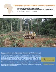
SGSOC ESIAManenguba Division <strong>and</strong> covers about 42,486 ha, while Block B is located within the Mundemba <strong>and</strong>Toko subdivisions of the Ndian Division <strong>and</strong> covers an approximate area of 30,600 ha.The Project Area was selected based upon the following criteria:recommendations from the Government of Cameroon;designation as agricultural l<strong>and</strong> by the Government of Cameroon;proximity to Kumba Town <strong>and</strong> to Cameroon‘s economic capital (Douala), which has a port <strong>and</strong>international airport;the fertility of its soil;synergies with other palm oil production facilities;l<strong>and</strong> that had been previously logged <strong>and</strong> is not covered by any existing ecological protections,thereby enabling SGSOC to build-out a sustainable oil palm operation consistent with RSPOPrinciples <strong>and</strong> Criteria;suitable climate for oil palm production with suitable rainfall <strong>and</strong> ideal temperatures; <strong>and</strong>,abundant, available labor in need of employment.The figure below provides an illustration of the Project Area in the Mundemba, Toko <strong>and</strong> Ngutisubdivisions.SGSOC xiii August 2011
SGSOC ESIAFigure 1 Project AreaProject DevelopmentThe development of the plantation will occur in four phases, with each phase lasting approximately oneyear. At the end of phase four, the Project will have prepared <strong>and</strong> planted 60,000 ha of l<strong>and</strong> with oilpalms. In order to achieve this objective, the Project will require a number of development activities,which include exp<strong>and</strong>ing nurseries, clearing vegetation, establishing civil infrastructure <strong>and</strong> establishingsocial infrastructure.NurseriesThe nursery sites will be prepared using a combination of manual labor, chainsaws <strong>and</strong> mechanicalpreparation with bulldozers <strong>and</strong> similar equipment. All work will be conducted in accordance with aVegetation Clearing <strong>and</strong> Biomass Management Plan <strong>and</strong> RSPO Principles <strong>and</strong> Criteria. The topsoilfrom the cleared area is used to fill polybags in which the oil palm seeds will be planted manually. Theseeds are tended in the polybags to until they are planted in the field after 12-18 months.Vegetation Clearing <strong>and</strong> Biomass ManagementSGSOC xiv August 2011
SGSOC ESIAThe Project Area will be prepared using a combination of manual labor, chainsaws, <strong>and</strong> mechanicalpreparation with bulldozers <strong>and</strong> similar equipment. Tree trunks, branches, leaves, <strong>and</strong> all biomass leftafter commercial timber is removed will be stacked in windrows <strong>and</strong> recycled as organic compost. Thispractice is in line with RSPO‘s requirements to increase soil fertility, help control erosion <strong>and</strong> helpprevent soil degradation.Civil InfrastructureThe Project will require a number of investments in civil infrastructure to prepare for full operations.These include investments in roads, water supply, electricity <strong>and</strong> solid waste disposal facilities.RoadsA network of roads will be used to transport fresh fruit bunch (FFB) from the plantations to the palm oilmills. Such roads are typically three meters wide for in-field transportation <strong>and</strong> five meters wide forroads to the mill. Roads will be built with bulldozers, leveled with graders <strong>and</strong> compacted.Water SupplyThe water required for the Project is expected to be supplied by local streams or extracted fromboreholes where surface water is not available. Water consumption during construction will varysignificantly, as the volume of consumption will depend on work activities.ElectricityAt the nurseries <strong>and</strong> other areas where power requirements are relatively small, diesel generators willbe installed. The electricity at the mills will be provided by highly efficient internal boilers <strong>and</strong> steamturbines using the biomass from the oil extraction process as fuel.Solid Waste Disposal FacilitiesIn addition to agricultural waste, which can be recycled as fertilizer, the Project will generate waste fromother sources. The quantities will be considerably smaller, but will require correct recycling or disposalin order to not significantly impact the environment. This waste will be disposed of in accordance withthe legislation of Cameroon (Law 96/12 or 5/8/96 Articles 42 - 56).<strong>Social</strong> InfrastructureSGSOC xv August 2011
SGSOC ESIAConstruction of housing will be required to support the Project workforce that does not already live inlocal villages. It is expected that 70% of the workforce will be drawn from existing residents. Thehousing construction plan developed for the Project is based on providing housing for the 30% nonresidentworkers. The build-out of the housing units will vary consistent with the field build out of theProject.Project OperationsOil Palm PlantationThe plantation will be subdivided into planting blocks for efficient management <strong>and</strong> operation, including:24 Estates - 2,500 ha per Estate;12 Complexes - 5,000 ha per Complex; <strong>and</strong>,3 Regions - 20,000 ha per Region.The operations of the oil palm plantation will require a substantial amount of investment in l<strong>and</strong>development, equipment, infrastructure <strong>and</strong> warehouses. The development of these resources will beorganized according to the division of the 24 2,500 hectare estates. The oil palm mills will most likelyact as the primary sites for offices, storage, housing <strong>and</strong> workshops, as well as the sources of water<strong>and</strong> power for these facilities.Palm Oil MillIt is anticipated that five mills, each with a processing capacity of 60 metric tons/hour (MT/hr) arerequired for the Project at full build-out. It is also anticipated that the mill superstructure <strong>and</strong> ancillarybuildings will be constructed to accommodate a maximum processing capacity of 75 MT/hr. Toincrease the mill output from 60 to 75 MT/hr, additional digester presses <strong>and</strong> cross conveyors can beinstalled.The mills being designed for the Project will use state-of-the-art technologies with the oil extractionprocesses. In line with the RSPO requirements, the following areas / activities will be adhered to <strong>and</strong>implemented:compliance with local/international environmental, labor, health <strong>and</strong> safety regulations;preparation <strong>and</strong> documentation of st<strong>and</strong>ard operating procedures (SOPs) on prudent millingpractices, including housekeeping <strong>and</strong> maintenance areas;SGSOC xvi August 2011
SGSOC ESIApreparation of an efficient water management plan <strong>and</strong> establishment of monitoring controls toreduce consumption <strong>and</strong> waste;preparation <strong>and</strong> implementation of health <strong>and</strong> safety policies; <strong>and</strong>,formal <strong>and</strong> structured training programs for mill employees on occupational, safety <strong>and</strong> health(OSH) issues.DecommissioningThe estimated productive life of an oil palm tree is 25 to 30 years, <strong>and</strong> the quantity of FFB produceddeclines as the trees age. Therefore, most plantations replant their trees once FFB yields begin todecline significantly. Replanting activities include:the establishment of a new nursery;removal of the old palm trees;biomass management of the old trees that are being replaced;field lining <strong>and</strong> holing for the new trees; <strong>and</strong>,transfer of the seedlings from the nursery.If plantations choose not to replant <strong>and</strong> rather ab<strong>and</strong>on the aging trees, activities include:the removal of equipment <strong>and</strong> structures; <strong>and</strong>,site restoration / rehabilitation.Project AlternativesAn oil palm plantation that can ultimately be certified by the RSPO has specific requirements in terms ofsoils, rainfall, elevation, temperature, existing l<strong>and</strong> uses, previous l<strong>and</strong> uses <strong>and</strong> existing habitat types.SGSOC required a relatively large area, about 73,000 ha, in order to get the total usable area requiredfor planting, about 60,000 ha, that it required for its large-scale Project. Given these requirements, theGovernment of Cameroon reviewed its portfolio of available agricultural l<strong>and</strong> <strong>and</strong> decided to grantSGSOC its Concession in the present location.Once the Concession was granted, SGSOC worked with the Government of Cameroon to improve theConcession boundaries <strong>and</strong> Project by removing all areas from the Concession within 3 km of theKorup National Park (KNP) so that forests would not be cleared within that buffer zone. SGSOC alsoSGSOC xvii August 2011
SGSOC ESIAworked with Government of Cameroon to remove some potentially higher value forests from theConcession <strong>and</strong> replace those with previously logged areas.There are no suitable alternative locations for the oil palm plantation within Cameroon.Baseline <strong>Environmental</strong> <strong>and</strong> <strong>Social</strong> ConditionsClimate <strong>and</strong> MeteorologyThe climate is hot <strong>and</strong> humid with two unequal seasons, one being wet, <strong>and</strong> the other dry. The wetseason runs from mid-March to the end of October. The climate in the Concession is influenced by thepresence of the massif Mountains of Cameroon, <strong>and</strong> specifically by Mount Kupe.The temperature varies rarely throughout the year with a mean monthly maximum in the dry season of31.8ºC <strong>and</strong> in the wet season of 30.2ºC. Solar radiation also varies little, ranging from about 199 to248 watts per square meter (W/m²).Air QualityFew industries are present in the area, <strong>and</strong> transportation by l<strong>and</strong> <strong>and</strong> air is very limited. Therefore, it isanticipated that air quality is not significantly affected by emissions from human activities. Someimpacts are expected due to the dry, Harmattan winds from the Sahara that bring dust <strong>and</strong> particulates,as well as smoke <strong>and</strong> particulates, from seasonal burning of brush for agricultural purposes.NoiseThe noise sources are limited to the natural fauna in the area <strong>and</strong> the intermittent passage ofmotorcycles <strong>and</strong> timber trucks. Therefore, the noise levels are quite low.TopographyThe topography of the Nguti area is primarily flat to undulating terrain. Altitudes within the neighboringBanyang-Mbo Wildlife Sanctuary (BMW Sanctuary) vary from about 120 to 1760 meters above sealevel (masl). The southern part of the Concession represents a small northern extension of the BakossiHills <strong>and</strong> rises to over 1700 meters.GeologySGSOC xviii August 2011
SGSOC ESIAIRAD conducted an extensive analysis on over 400 samples of the soil <strong>and</strong> l<strong>and</strong> within the ProjectArea. Overall they found its soil good for producing high-yielding oil palms. Six main geological typeshave been identified from Mundemba <strong>and</strong> the KNP support zone, which include recent alluvium,Cretaceous sediments, Mio-Pliocene sediments, Pre-Cambrian gneiss, Tertiary (older) basalt, <strong>and</strong>Tertiary dolerite (Sources: MINPAT, 1989, Gartlan, 1985). Cretaceous <strong>and</strong> Mio-Pliocene sedimentswith recent alluvium in the creeks <strong>and</strong> marshes dominate the Mosongeseli-Isangele area. Isolatedbasaltic plateaus, which rise above the general level of sediments, also occur. The Mundemba-Tokoarea consists largely of basaltic lava flows produced from volcanoes in the Rumpi Hills.Water ResourcesThe region is rich in surface water networks, with many small <strong>and</strong> temporary streams. The Bake River<strong>and</strong> its tributaries form the basis for the hydrographic net of the forest. The Bake River originates fromthe Nkwende Hills <strong>and</strong> flows in a southerly direction to the south of the Osirayib village. Downstream,the Bakebe River joins Bake River near the Ayong village, <strong>and</strong> the Bake River continues flowing in anorthwesterly direction. Three upper tributaries of the Cross River, the Mbu or Mbe, the Mfi-Mie, <strong>and</strong>the Bashuwe, also drain the BMW Sanctuary. All of these rivers originate from the Bakossi Mountainssouth of the BMW Sanctuary <strong>and</strong> then empty to the Manyu River.FloraA total of 403 vascular plant species belonging to 272 genera <strong>and</strong> 81 families were recorded in theConcession. Families rich in species (e.g. represented by more than 10 species with number ofspecies indicated in parenthesis) included Fabaceae (49), Rubiaceae (36), Euphorbiaceae (30),Apocynaceae (22), Malvaceae (22; including Tiliaceae, Sterculiaceae & Bombacaceae), Annonaceae(18), Meliaceae (12), Moraceae (11) <strong>and</strong> Sapindaceae (11). In contrast, 24 families had only onespecies recorded.Only one Black Star (e.g. endemic) species (Cylicomorpha solmsii) <strong>and</strong> six Gold Star species(Afrostyrax lepidophyllus, Amanoa strobilacea, Cola buntingii, Dicranolepis disticha, Dasylepisracemosa <strong>and</strong> Dichapetalum tomentosum) were recorded.FaunaOver 106 different species were recorded in the Concession. Of the species detected or encountered,the majority are common species in Cameroon with wide distribution in the lowl<strong>and</strong> forest region.Furthermore, extensive human use <strong>and</strong> commercial logging activity has degraded the forests <strong>and</strong>SGSOC xix August 2011
SGSOC ESIAhabitats of the Concession such that critical habitat for the International Union for Conservation ofNature (IUCN) listed species are now only found in the surrounding protected areas of the KorupNational Park (KNP), BMW Sanctuary, the Bakossi Mountains National Park, Rumpi Hills <strong>and</strong> MountCameroon.The forest elephant (Loxodonta a. cyclotis), however, is an exception to these findings. The forestelephant is listed as endangered by the IUCN (2002), <strong>and</strong> feeding signs were recorded at the boundaryof the Concession <strong>and</strong> Sanctuary close to River Boa. Hence, there seems to be local migrationbetween the river <strong>and</strong> the Sanctuary, potentially indicating forest elephant activity at the edge of theConcession. When developing the area near the River Boa, mitigation measures will be taken toprovide both a buffer zone, as well as an elephant trench, to help protect the forest elephants <strong>and</strong> theplantation.<strong>Social</strong> BaselineThe Human Development Report for Cameroon places it in the bottom quartile of its index. Overall,Cameroon ranks 131 st out of 169 countries in the 2010 Human Development Index Rankings. 1 Thetable below provides details for key human development indicators in Cameroon.Table 2 Cameroon Human Development IndicatorsHuman development index value (2010) 0.46Human development index rank (2010) 131Adult literacy rate (% aged 15 <strong>and</strong> above) (2005-2008) 76Life expectancy at birth (2010) 51.7Net enrolment ratio in primary education (%) (2001-2009) 88Survival rate to last primary grade (%) (2008) 73Under-five mortality rate (per 1,000 live births) (2008) 131Maternal mortality ratio (per 100,000 live births) (2003-2008) 10001 http://hdr.undp.org/en/statistics/.SGSOC xx August 2011
SGSOC ESIAAdditionally, primary <strong>and</strong> secondary research was undertaken to develop a clear underst<strong>and</strong>ing of thesocial baseline for inhabitants within the Project Area. The primary sources were obtained from fieldsurveys <strong>and</strong> interviews, <strong>and</strong> secondary sources were gathered from several data sources such asbooks, research papers, internet searches <strong>and</strong> Government publications. The results are summarizedbelow <strong>and</strong> can be found in more detail in the ESIA.The primary l<strong>and</strong> use in the Concession is agriculture, consisting of shifting cultivation (slash-<strong>and</strong>-burn)for primary subsistence purposes, vegetable gardens to supplement subsistence crops (cassava,plantains, bananas, coco yams), <strong>and</strong> cash crops, such as cocoa, coffee <strong>and</strong> oil palm. Livestockproduction is poor in the area, <strong>and</strong> domestic animals are raised more for ceremonial occasions <strong>and</strong>honored guests rather than for wide consumption.General social services such as roads, hospitals, schools clean water <strong>and</strong> electricity were less evidentin remote hamlets than in pre-urban settlements. Villagers typically receive news <strong>and</strong> informationthrough the radio, <strong>and</strong> communicate by mobile phone <strong>and</strong> community meanings. There does notappear to be any availability of Internet services. Most of the villagers had heard of the Project, <strong>and</strong>many expressed interest in working with SGSOC.Potential Major Project <strong>Impact</strong>sThis section consolidates the major impacts for the environmental <strong>and</strong> social components to determinethe significance of the aggregated impacts on that component, assuming all proposed mitigationmeasures are implemented. If, after the implementation of all proposed mitigation measures, a highimpact exists, then that component will be further analyzed, <strong>and</strong> additional mitigation <strong>and</strong>/or monitoringmeasures are proposed in the following section.Table 3 Major <strong>Environmental</strong> <strong>and</strong> <strong>Social</strong> <strong>Impact</strong>sMediumAffectedProjectPhaseActivity/Sourceof <strong>Impact</strong>Effects of the<strong>Impact</strong>Evaluation of the Importance of the <strong>Impact</strong>Intensity Extent Duration ImportanceSGSOC xxi August 2011
SGSOC ESIAMediumAffectedProjectPhaseActivity/Sourceof <strong>Impact</strong>Effects of the<strong>Impact</strong>Evaluation of the Importance of the <strong>Impact</strong>Intensity Extent Duration ImportanceAir QualityAir QualityFloraFloraFloraFaunaNursery,plantation, mill<strong>and</strong>infrastructuredevelopment.Nursery,plantation, mill<strong>and</strong>infrastructuredevelopment.Construction<strong>and</strong> operation ofmills <strong>and</strong>infrastructure.Construction<strong>and</strong> operation ofnurseries <strong>and</strong>plantations.Operations ofthe mills,infrastructure,nurseries, <strong>and</strong>plantations.Construction<strong>and</strong> operation ofmills, <strong>and</strong>infrastructure.Combustionemissions <strong>and</strong>clearing of biomass.Combustionemissions <strong>and</strong>production of palmoil that could offsetburning of fossilfuels; use of biomassfor steam <strong>and</strong>electricity generation;digestion of POME,which will createmethane <strong>and</strong> CO2,both GHGs.Relatively smallareas of l<strong>and</strong> will becleared of vegetationin five locations formills <strong>and</strong> socialinfrastructure.Approximately60,000 ha of l<strong>and</strong> willbe cleared <strong>and</strong>replaced with oilpalms <strong>and</strong> covercrops.Transportationbetween theConcession <strong>and</strong> portfacilities <strong>and</strong> othersources of supply forProject operationscan bring invasivespecies into thearea. Large areas ofl<strong>and</strong> will be visitedoften by people withaccess to outsideareas.Relatively smallareas of l<strong>and</strong> will becleared of vegetationin five locations formills <strong>and</strong> socialinfrastructure.Creation of GHG fromcertain combustion gases,as well as clearing ofbiomass that will eitherdecay or be burned <strong>and</strong>will therefore contribute toclimate change until theplantation areas arereplanted.Creation of GHGs that willcontribute to climatechange, but with offsetsdue to use of biomass forelectricity <strong>and</strong> steamgeneration, <strong>and</strong> possibleuse of palm oil as fossilfuel replacement.L<strong>and</strong> will be cleared ofnatural vegetation <strong>and</strong>either replaced with manmadestructures or limitedvegetation.Natural vegetation will belost.Medium International Short-term MajorLow International Long-term MajorHigh Local Permanent MajorHigh Local Permanent MajorLarge extent of l<strong>and</strong> in theplantation will bevulnerable to colonizationby invasive species,which then have theability to invade nonplantationareas. Low Regional Long-term MajorMobile fauna will flee tosurrounding areas withintact vegetation, ifpossible, creatingincreased competition forhabitat <strong>and</strong> resources,<strong>and</strong> less mobile fauna willmaybe destroyed duringthe clearing.High Local Permanent MajorSGSOC xxii August 2011
SGSOC ESIAMediumAffectedProjectPhaseActivity/Sourceof <strong>Impact</strong>Effects of the<strong>Impact</strong>Evaluation of the Importance of the <strong>Impact</strong>Intensity Extent Duration ImportanceFaunaFaunaBiodiversityBiodiversityLivelihoodsConstruction<strong>and</strong> operation ofnurseries <strong>and</strong>plantations.Construction<strong>and</strong> operation ofnurseries <strong>and</strong>plantations.Construction<strong>and</strong> operation ofthe mills,infrastructure,nurseries, <strong>and</strong>plantations.Construction<strong>and</strong> operation ofthe mills,infrastructure,nurseries, <strong>and</strong>plantations.Construction ofthe nurseries,plantations,mills, <strong>and</strong>infrastructure.Approximately60,000 ha of forestwill be cleared <strong>and</strong>replaced with oilpalms <strong>and</strong> covercrops.Concentration offauna in protectedareas within theConcession willcreate easier huntingopportunities forlocal hunters.Approximately60,000 ha of forestwill be transformedinto palm plantationalong with thedevelopment ofsome industrial,commercial, <strong>and</strong>residential/socialinfrastructure.Approximately60,000 ha of forestwill be transformedinto palm plantationalong with thedevelopment ofsome industrial,commercial, <strong>and</strong>residential/socialinfrastructure.Approximately60,000 ha of forestwill be transformedinto palm.Mobile fauna will flee toareas within theConcession that will bemaintained asconservation zones, or, ifpossible, will flee outsidethe Concession to eitherProtected Areas or othersecondary forest wherethey will compete withexisting fauna for habitat.Less mobile fauna will bedestroyed during theclearing.High Regional Permanent MajorHunting pressure for bushmeat will increase in theprotected areas within theConcession. High Local Long-term MajorThe conversion willdestroy existingbiodiversity in about 75%of the Concession.Stresses will be placed onthe remaining 25% of theConcession as well as theareas immediatelysurrounding theConcession due to theincreased dem<strong>and</strong> onhabitats both from faunafleeing into it <strong>and</strong> higherconcentrations of huntingpressure.Protected species can bedisturbed or destroyed ifadequate mitigationmeasures are notimplemented throughoutthe development process.Protected species outsidethe Concession could bedisturbed by faunamigration outside theConcession.Clearing of l<strong>and</strong> for theplantation can take l<strong>and</strong>currently used fortraditional livelihoodactivities such asagriculture, collection ofNTFPs, <strong>and</strong> hunting.High Regional Permanent MajorMedium Regional Long-term MajorHigh Local Long-term MajorSGSOC xxiii August 2011
SGSOC ESIAMediumAffectedProjectPhaseActivity/Sourceof <strong>Impact</strong>Effects of the<strong>Impact</strong>Evaluation of the Importance of the <strong>Impact</strong>Intensity Extent Duration ImportanceLivelihoodsLivelihoodsLivelihoodsLivelihoodsLivelihoodsConstruction ofthe nurseries,plantations,mills, <strong>and</strong>infrastructure.Operation of allthe facilitiesOperation ofInfrastructurefacilities.Operations ofinfrastructurefacilities.Construction ofinfrastructurefacilitiesApproximately 1000construction jobs willbe created over thecourse of the 12-yeardevelopment phase.Approximately 7,500full time employeeswill be hired by theProject when fullyoperational.Educationalopportunities will beprovided to thechildren of plantationworkers for free <strong>and</strong>may be extended tochildren of nonworkersthat livewithin theConcessiondepending on costsharingarrangements withthe Government.Improved health carefacilities will beprovided to theplantation workers<strong>and</strong> may beextended to nonworkersthat livewithin theConcessiondepending on costsharingarrangements withthe Government.Roads will beimproved to allow forsmoothcommunication <strong>and</strong>transportationbetween theconcession area <strong>and</strong>markets.These jobs will have asignificant positiveinfluence both on thosethat secure the jobs aswell as people that willsell goods <strong>and</strong> services tothe construction workers<strong>and</strong> to SGSOC <strong>and</strong> itscontractorsThese jobs will have asignificant positiveinfluence both on thosethat secure the jobs aswell as people that willsell goods <strong>and</strong> services tothe workers <strong>and</strong> toSGSOC duringoperations.These opportunities willgreatly exp<strong>and</strong> both thenumbers of people thatwill have access toeducation as well as thequality of that education.Transition to a more cashbasedeconomy will alsodecrease the need forchildren to choosebetween school <strong>and</strong>working on family farms.These opportunities willgreatly exp<strong>and</strong> both thenumbers of people thatwill have access to healthcare as well as the qualityof that care.Local inhabitants willbenefit from improvedroads which will allow foreasier commercial <strong>and</strong>social travel <strong>and</strong>communication.High National Short-term MajorHigh National Long-term MajorHigh Local Long-term MajorHigh Local Long-term MajorHigh Local Long-term MajorSGSOC xxiv August 2011
SGSOC ESIAMediumAffectedProjectPhaseActivity/Sourceof <strong>Impact</strong>Effects of the<strong>Impact</strong>Evaluation of the Importance of the <strong>Impact</strong>Intensity Extent Duration ImportanceLivelihoodsGovernmentRevenuesOperations ofinfrastructurefacilities.Operations ofinfrastructurefacilities.Housing foremployees will beconstructed.Taxes paid bySGSOC <strong>and</strong>employees.Improved quality of life foremployees <strong>and</strong> theirfamiliesVery significant increasein local <strong>and</strong> national taxrevenue.High Local Long-term MajorMedium National Long-term MajorMitigation MeasuresSGSOC will make significant investment throughout the life of the Project in order minimize the negativeimpact of activities related to construction, l<strong>and</strong> clearing <strong>and</strong> agriculture operations. In addition, over the firstten years of the Project, approximately CAF 75 billion will be spent on creating positive impact for thecommunity in areas such as roads development, clean water infrastructure, schools, health centers,outgrower programs <strong>and</strong> anti-poaching programs. Some of the important mitigation measures aresummarized below.Greenhouse Gas EmissionsThe planting of oil palm trees <strong>and</strong> cover crops over most of the area cleared will offset the clearing ofbiomass. Electricity <strong>and</strong> steam generation during operations will be generated from burning of biomasswastes from the mill operations, <strong>and</strong> will therefore be GHG neutral – a benefit over burning fossil fuels.Production of biofuels shall offset burning of fossil fuels on equipment used in the Concession duringnormal operation. SGSOC will also capture methane (a significant GHG) produced by the digestion ofPOME <strong>and</strong> use that as fuel for the mill.Loss of Natural VegetationNatural vegetation, in the form of secondary forest, will be cleared for Project development. Buffers ofexisting vegetation will be maintained between the plantation <strong>and</strong> both KNP <strong>and</strong> the BMW Sanctuary,<strong>and</strong> buffers will be maintained around waterways. In addition, HCV forest areas, vegetation on steepslopes (greater than 30º), <strong>and</strong> sacred sites as well as agricultural l<strong>and</strong> used by the villages within theConcession will remain in their current state.Risk of Invasive SpeciesSGSOC xxv August 2011
SGSOC ESIAThe Project will monitor the occurrence of invasive species both to protect the natural environment <strong>and</strong>to protect the plantation against all types of pests. If invasive species are identified, they will beeradicated by manual methods if possible, then by biological methods, <strong>and</strong> finally by chemical means.Loss of Fauna in the ConcessionLoss of fauna in the Concession will be likely due to the loss of habitat during l<strong>and</strong> clearing for Projectdevelopment. Buffers of existing vegetation will be maintained between the plantation <strong>and</strong> both KNP<strong>and</strong> the BMW Sanctuary, <strong>and</strong> buffers will be maintained around waterways. In addition, HCVF areas,vegetation on steep slopes (greater than 30º), <strong>and</strong> sacred sites within the Concession will remainuntouched by the Project. Fauna will be able to use these areas for habitat, but the decrease in totalavailable habitat will result in an overall loss of fauna.Loss of Fauna Outside the ConcessionThe composition of fauna populations outside the Concession will be impacted by due to the migrationof some mobile fauna from cleared areas to un-cleared or protected areas. The Project is mitigatingimpacts on the KNP <strong>and</strong> BMW Sanctuary by providing for buffer zones within the Concession betweencleared areas <strong>and</strong> these protected areas of 3 km <strong>and</strong> 500 m, respectively. Part of the purpose of thesebuffer zones is to absorb <strong>and</strong> attenuate the changes in fauna populations before those changes canreach the protected areas.Increased Hunting PressureIn order to decrease the dem<strong>and</strong> for local bush meat, SGSOC will take the following measures:decrease hunting pressure in the Concession by ensuring that adequate supplies of meat otherthan local bush meat as well as other protein sources are available in stores <strong>and</strong> markets within theConcession;educate its employees on the adverse impacts of hunting <strong>and</strong> consuming bush meat;to the degree possible, prohibit <strong>and</strong> enforce prohibitions on hunting inside the Concession;sponsor education programs in local villages about the adverse impacts of hunting <strong>and</strong> consumingbush meat; <strong>and</strong>sponsor programs to transition hunters to other, sustainable livelihood activities.Loss of Traditional Livelihood ActivitiesSGSOC xxvi August 2011
SGSOC ESIATraditional livelihood activities inside the Concession such as subsistence agriculture, gathering <strong>and</strong>use of NTFPs, <strong>and</strong> hunting will be adversely impacted by the Project due primarily to the loss of l<strong>and</strong>available for these activities. These activities can be replaced to a large degree by full-timeemployment provided by the Project, employment provided by businesses that will be established withthe support of SGSOC, <strong>and</strong> the implementation of modern agriculture programs. Additionally, theseactivities can continue to be practiced, but likely to a lower intensity level, within the areas that will notbe cleared by the Project.Increased Health Risks During ConstructionThe Project will attempt to recruit most of its construction workers from the immediate area, thusminimizing the number of single men migrating for work. SGSOC will also ensure that it <strong>and</strong> itscontractors provide adequate training <strong>and</strong> enforcement of codes of conduct to minimize workerparticipation in risky activities. In order to further mitigate this potential impact, SGSOC will conductcommunity training <strong>and</strong> awareness programs.Monitoring <strong>and</strong> ManagementThe Project will develop a detailed <strong>Environmental</strong> <strong>and</strong> <strong>Social</strong> Monitoring Plan to monitor key elementsof both the biophysical <strong>and</strong> human environments. The purpose of this monitoring will be to ensure thatsignificant impacts were correctly identified in the assessment process, then to monitor theeffectiveness of the mitigation measures. The results of monitoring activities will be regularly reviewedto determine if existing management measures are adequate, or if those measures need to be revised,deleted, or supplemented.Overall <strong>Impact</strong> <strong>Assessment</strong>The ESIA has identified the Project‘s activities that could impact the existing environmental <strong>and</strong> socialconditions of the Project Area <strong>and</strong> has provided an assessment for the degree of impact which mayresult. Mitigation plans have been developed for each identified negative impact of the Project whilethe positive impacts will be accentuated. Monitoring <strong>and</strong> management will play a key role movingforward in order to maintain the effectiveness of the mitigation initiatives.<strong>Environmental</strong> Project <strong>Assessment</strong>The most significant impacts of the Project will be associated with Project development. In particular,clearing of existing vegetation to allow for planting will be a significant impact during ProjectSGSOC xxvii August 2011
SGSOC ESIAdevelopment. Mitigation plans have been established to limit the impact of this activity which includeclearing l<strong>and</strong> with manual <strong>and</strong> mechanical processes according to RSPO guidelines; creating bufferzones between the Project <strong>and</strong> protected areas; creating of buffer zones near rivers <strong>and</strong> streams;identifying <strong>and</strong> protecting HCV areas within the Concession which include steep slopes, primaryforests, sacred areas, <strong>and</strong> agricultural l<strong>and</strong> used by the local inhabitants. Beyond these, no mitigationmeasures other than decreasing the plantation size is available to significantly mitigate the loss ofnatural vegetation, which would reduce the Project‘s significant positive social benefit, therefore noadditional mitigation measures are proposed for this impact.The chance for unplanned events <strong>and</strong> their potential consequences associated with this Project is verylow due to the controlled nature of its development. Emergency plans <strong>and</strong> flexible developmentpractices are being developed to allow for effective response to unforeseen impacts connected with theProject‘s development <strong>and</strong> operations.Mitigation measures will be monitored <strong>and</strong> reviewed regularly to ensure their adherence <strong>and</strong>effectiveness. Any contractors employed as part of the Project development will be expected to followthe mitigation plans <strong>and</strong> commitments made by SGSOC.Socioeconomic Project <strong>Assessment</strong>Formal <strong>and</strong> informal meetings with the communities within the Project Area have revealed strongsupport amongst most community members <strong>and</strong> chiefs. The communities recognize that the significant<strong>and</strong> long-term investment in the area will bring significant improvements in the day-to-day quality of lifefor many within the community as well as provide significant employment opportunities.Among the numerous socioeconomic benefits associated with the Project areDirect sustainable employment for 7,000 – 8,000 individuals;Increased knowledge <strong>and</strong> skills from operation <strong>and</strong> training;Indirect employment for several thous<strong>and</strong> other individuals within small- <strong>and</strong> medium-sizedbusinesses;Support for local small holders <strong>and</strong> farm operators;Decrease in the rural exodus from Southwest Cameroon;Investment in education for local communities;Investment in healthcare for local communities;SGSOC xxviii August 2011
SGSOC ESIAIncreased public awareness of the socioeconomic needs of the local communities for roads,healthcare, <strong>and</strong> other infrastructure <strong>and</strong> social investments at an international, national, <strong>and</strong>community level through consultations <strong>and</strong> the publication of documents;Employee housing;Access to clean water <strong>and</strong> electricity; <strong>and</strong>,Tax revenues for the Government.Maintaining continued communication through a coherent policy of interaction <strong>and</strong> exchange with thelocal populations is essential for a lasting constructive relationship. In particular, there continues to beconcern among some local individuals that the Project will take l<strong>and</strong> which is currently in use foragricultural or residential purposes. SGSOC is committed to respect the current boundaries of villages<strong>and</strong> farml<strong>and</strong>s, as well as to provide growth zones for the communities, <strong>and</strong> it is essential to continue toemphasize this policy. Additionally, some inhabitants may believe SGSOC will construct new roadsconnecting villages through protected areas <strong>and</strong> other locations. While SGSOC will work with national<strong>and</strong> international governments <strong>and</strong> NGOs to improve the road network, it is the jurisdiction of theGovernment of Cameroon to identify <strong>and</strong> plan new roads, particularly within protected areas.SGSOC xxix August 2011
SGSOC ESIARÉSUMÉ NON TECHNIQUEIntroductionLa dem<strong>and</strong>e en huile de palme est en augmentation à cause de l‘utilisation de plus en plus croissantedes huiles végétales pour la production des biocarburants et la consommation de ce type d‘huile dansles pays en voie de développement tels que le Cameroun. Actuellement, les premiers producteursd‘huile de palme sont l‘Indonésie et la Malaisie, qui produisent environ 80% de la production mondiale.Les ressources agricoles disponibles pour le développement de l‘Afrique fourniront des bénéfices auxpopulations locales en quête d‘emploi et servent de source fiable d‘huile de palme. De nombreusesagences internationales de développement et d‘organisations non gouvernementales (ONG) militentpour l‘accroissement de la production d‘huile de palme en Afrique de l‘Ouest en raison de ses effetspositifs sur l‘emploi et d‘autres avantages sociaux.SG Sustainable Oils Cameroon, Ltd. (SGSOC) entend développer un Projet de production d‘huile depalme commerciale en République du Cameroun (Projet). Le premier objectif du Projet est deconcevoir, construire et faire fonctionner des unités de transformation d‘huile de palme. SGSOC estengagé à développer et à mener un Projet d‘huile de palme respectant les normes environnementalesqui aura des bénéfices énormes sur plusieurs segments de l‘économie camerounaise et sur lescommunautés locales. A cet effet, SGSOC produira de l‘huile de palme certifiée RSPO (Table rondesur l‘Huile de Palme Durable). Une fois certifiée, SGSOC sera un contributeur important du mouvementpour une production durable de l‘huile de palme, fixant les normes pour les autres opérateurs de cedomaine.SGSOC et le Gouvernement du Cameroun ont signé la Convention d‘établissement pour la mise enplace et le fonctionnement du Projet sur une superficie de 73,086 ha au Sud-ouest Cameroun(Concession) le 17 Septembre 2009. SGSOC prévoit que la surface cultivée totale soit d‘environ60,000 ha. La surface restante de la Concession sera protégée en tant que zone comprenant desressources sensible sur le plan environnemental ou social, des infrastructures des plantations et desinfrastructures sociales ainsi que des terres pour les activités de subsistance des villageois.Le Projet apportera des avantages significatifs à savoir:Des emplois directs pour 7000 – 8000 individus;Des emplois indirects pour plusieurs milliers de personnes possédant des petites et moyennesentreprises;SGSOC xxx August 2011
SGSOC ESIALa baisse de l‘exode rural partir du Sud-ouest Cameroun;Investissement dans l‘éducation pour les communautés riveraines;Investissement dans les soins de santé pour les communautés riveraines;Logement;Accès à l‘eau potable et à l‘électricité; et,Recettes fiscales pour le Gouvernement.Cadre légal, Consultation, et ParticipationSGSOC aidera le Projet à fonctionner selon les politiques, directives et réglementations internationales,nationales et régionales. En outre, le Projet utilisera les informations recueillies pendant lesconsultations publiques pour orienter et calibrer les activités du Projet.Politiques, Directives et Réglementations Internationales, Nationales et RégionalesParmi les politiques, directives et réglementations internationales, nationales et régionales, l‘on peutciter:• missions, politiques et meilleurs pratiques internes des entreprises;• stratégies, législation, permis et autorisations du Cameroun;• Principes de RSPO;• normes de performance de l‘IFC;• Principes de l‘Equateur;• les Directives de l‘UN Global Compact; et,• les Bonnes pratiques industrielles internationales (GIIP) qui aident à définir les meilleurespratiques industrielles.Ils sont décrits en détail dans le rapport de l‘EIES.Consultations et ParticipationConformément aux directives de l‘EIES, SGSOC a mené une série de consultations publiques pourl‘EIES Durant la préparation du présent rapport. Ces auditions publiques ont servi à identifier lesproblèmes potentiels et à proposer des recomm<strong>and</strong>ations au Projet. Les principaux objectifs desauditions publiques menées dans le cadre le l‘EIES ont permis:SGSOC xxxi August 2011
SGSOC ESIAde présenter le Projet aux principales parties prenantes;de remplir les exigences de la législation camerounaise en matière d‘auditions publiques et lesnormes de l‘IFC; et,de comprendre et de répondre aux préoccupations et problèmes des parties prenantes.Une liste des auditions publiques menées pour l‘EIES est jointe ci-dessous.Table 1 Liste des Auditions PubliquesDate Place Partenaires concernés22/09/2010 MINIMIDT, YaoundéMinistère des Mines et du DéveloppementTechnologique(MINIMIDT)22/09/2010 MINEE, Yaoundé Ministère de l‘Energie et de l‘Eau (MINEE)22/09/2010 MINSANTE, Yaoundé Ministère de la Santé Publique(MINSANTE)22/09/2010 MINAGRI, YaoundéMinistère de l‘Agriculture et du DéveloppementRural(MINADER)23/09/2010 MINCOMMERCE, Yaoundé Ministère du Commerce (MINCOMMERCE)23/09/2010 MINTSS, YaoundéMinistère du Travail et de la Sécurité <strong>Social</strong>e(MINTSS)27/09/2010 Chariot Hotel, BueaOrganisations de développent et deconservation, plusieurs autorités locales,traditionnelles, des délégués régionaux dedivers Ministères, des entreprisesagroindustrielles (PAMOL)Nguti Council Hall,Département du KoupeManengouba, Région du SudouestChefs, notables, Maires, Conseillers, ONGlocales, officiers de Gendarmerie et politiciensMundemba Council Hall, pour30/09/2010les arrondissements deChefs, notables, Maires, élites, Chef de KonyeMundemba et Toko,dans le Département de la MemeDépartement du NdianRégion du Sud-ouest04/08/2011 – Mundemba Mundemba L<strong>and</strong> Consultative BoardSGSOC xxxii August 2011
SGSOC ESIA07/08/201108/08/2011 MundembaLes chiffres ci-dessous illustrent la zone de laConcession dans les arrondissements de àMundemba, Toko, et Nguti.Description du ProjetLe Projet de concerne la création d‘une plantation d‘huile de palme durable dans la région du sud-ouestCameroun. Ce Projet englobera la création et l‘entretien des pépinières, d‘usines de traitement, destructures de stockage, de logements et d‘autres améliorations des infrastructures.SituationL‘ensemble du site du Projet comprend environ 73,086 ha de terrain (Zone du Projet) et a été divisé endeux gr<strong>and</strong>s blocs (Bloc A et Bloc B). Le Bloc A est situé dans l‘arrondissement de Nguti dans leDépartement du Kupe-Manenguba et couvre environ 42,486 ha, t<strong>and</strong>is que le bloc B est situé dans lesarrondissements de Mundemba et Toko, Département du Ndian Division et couvre environ 30,600 ha.Le site du Projet a été sélectionné selon les critères suivants:recomm<strong>and</strong>ations du Gouvernement du Cameroun;désignation en tant que terres agricoles par le Gouvernement du Cameroun;proximité avec la ville de Kumba et de la capitale économique du Cameroun(Douala), quipossède un port et un aéroport international;fertilité des sols;synergies avec d‘autres unités de production d‘huile de palme;des terres sur lesquelles des arbres ont été coupés précédemment et ne sont pas couverte parla protection écologiques, permettant à SGSOC de créer une usine durable d‘huile de palmeconforme aux normes RSPO;un climat adéquat pour la production d‘huile de palme avec une pluviométrie et destempératures idéales; et,une main d‘œuvre abondante et disponible enquête d‘emplois.SGSOC xxxiii August 2011
SGSOC ESIAFigure 1 Carte de la Zone sous Concession à Mundemba, Toko et NgutiDéveloppement du ProjetLa création de la plantation se déroulera en quatre phases dont chacune durera un an. A la fin de laquatrième phase, le Projet aura préparé et planté des palmiers sur 60 000 ha de terres. Afind‘atteindre cet objectif, le Projet mènera un certain nombre d‘activités de développement comprenantl‘extension des pépinières, le désherbage, la mise sur pied d‘infrastructures civiles et sociales.PépinièresElles seront préparées à l‘aide de travailleurs manuels, de scies à moteur, de bulldozers oud‘équipements similaires. Tous les travaux seront menées conformément au plan de défrichage et degestion de la biomasse, et aux directives RSPO. La couche arable des zones défrichées est utiliséepour remplir les sachets en plastic dans lesquels les rejetons de palmiers seront plantés manuellement.Les semences sont conservés dans ces sachets en plastic jusqu‘à leur mise en terre 12 à 18 mois plustard.Déblaiement et Gestion de la BiomasseSGSOC xxxiv August 2011
SGSOC ESIALa Zone de Projet sera préparée à l‘aide de travailleurs manuels, de scies à moteur, de bulldozers oud‘équipements similaires. Les trocs, branches et feuilles d‘arbres et toute la biomasse laissée aprèsutilisation sur la Zone de Projet ainsi que le bois commercial seront enlevée placée en <strong>and</strong>ains, puisrecyclés en engrais organique. Cette pratique est conforme aux exigences RSPO pour accroître lafertilité des sols, lutter contre l‘érosion et prévenir la dégradation des sols.Infrastructures CivilesLe Projet nécessitera un certain nombre d‘investissements en infrastructures civiles pour préparer samise en route effective. Il s‘agit entre autres des routes, de l‘adduction d‘eau, de l‘électricité etd‘installation de stockage des déchets solides.Les RoutesUn réseau de routes sera utilisé pour acheminer les FFB des plantations vers les usines d‘huile depalme. Ces routes auront une largeur de 3 mètres à l‘intérieur des plantations et de 5 mètres desplantations vers l‘usine. Les routes seront crées par les bulldozers, aplanies par les niveleuses etcompactées.Adduction d’eauL‘eau nécessaire pour le Projet devrait être fournie par les sources locales ou extraite des bornesfontaines là où l‘au de surface est disponible. La consommation d‘eau pendant la phase deconstruction variera de façon significative car le volume de consommation dépendra des activités sur leterrain.ElectricitéDans les pépinières et les autres zones où les besoins en énergie sont relativement faibles, desgroupes électrogènes diesel seront installés. L‘électricité de l‘usine sera fournie par des chaudièresinternes très efficaces et des turbines à vapeur alimentées par la biomasse issue de l‘extraction del‘huile.Stockage de Déchets SolidesEn plus des déchets agricoles, qui peuvent être recyclés en engrais, le Projet générera des déchetsd‘autres sources. Les quantités seront considérablement plus petites, mais elles nécessiteront unrecyclage ou un stockage correct afin de ne pas avoir un impact important sur l‘environnement. CesSGSOC xxxv August 2011
SGSOC ESIAdéchets seront stockés conformément aux dispositions de la législation camerounaise (Loi 96/12 ou5/8/96 Articles 42 - 56).Infrastructures <strong>Social</strong>esLa construction des logements sera nécessaire pour héberger les travailleurs qui ne résident pas dansles villages voisins. 70% de la main d‘œuvre proviendra des villageois qui résident près des sites duProjet. Le plan de construction des logements préparé pour le Projet prévoit la fourniture de logementsà 30% de travailleurs non résidents. La construction des logements dépendra de l‘avancement duProjet.Opérations du ProjetLa PalmeraieLa palmeraie sera divisée en blocs, pour une meilleure gestion et un meilleur fonctionnement:24 parcelles – 2 500 ha par parcelle12 Complexes – 5 000 ha par Complexe3 Régions – 20 000 ha par RégionLe fonctionnement de la palmeraie nécessitera un gr<strong>and</strong> investissement dans la préparation du terrain,l‘équipement, les infrastructures et les magasins. Le développement de ces ressources sera organiséen parcelles de 24 2 500 hectares. L‘usine d‘huile de palme servira de premier site pour les bureaux,le stockage, les logements et les ateliers ainsi que de source d‘eau et d‘énergie pour ces installations.Usine d’Huile de PalmeL‘on prévoit que cinq unités de traitement d‘une capacité de 60 tonnes/métriques par heure (MT/h) sontnécessaires pour le Projet dans sa phase pleinement opérationnelle. Pour accroître la productivité del‘usine de 60 à 75 MT/h, l‘on peut installer des cuves de digestion des presses et des transporteurstransversaux additionnels.Les broyeurs conçus pour ce Projet utiliseront des technologies de pointe en matière d‘extractiond‘huile. Conformément aux exigences de RSPO, les domaines d‘activités suivants seront respectés:conformité aux réglementations locales/internationales en matière environnemental, du travail,de la santé et de sûreté;SGSOC xxxvi August 2011
SGSOC ESIApréparation et documentation des Instructions permanents d‘opération (IPO) sur les pratiquesprudentes en matière de broyage, y compris l‘administration interne et la maintenance;préparation d‘un plan efficace de gestion de l‘eau et établissement de contrôles afin de réduirela consommation et les déchets;préparation et mise en œuvre de politiques sanitaires et de sûreté ; et,programmes de formation structurés pour les employés de l‘usine sur les questionsprofessionnelles, sanitaires et de sûreté (OSH).DémantèlementLa durée de vie d‘un palmier est de 20 à 30 ans, et la quantité de FFB produite baisse au fur et àmesure que le palmier vieillit. Par conséquent, la plupart des plantations replantent leurs arbres à partirdu moment où la production de FFB commence à baisser de manière significative. Les activités dereplantation comprennent:la création d‘une nouvelle pépinière;la coupe des vieux palmiers;la gestion de la biomasse des vieux palmiers en cours de remplacement;l‘alignement du sol et le creusage des trous pour les nouveaux arbres et,le transfert des semences de la pépinière vers la plantation.Si l‘on choisit de ne pas replanter et d‘ab<strong>and</strong>onner les vieux arbres, les activités comprennent:le démantèlement des équipements et des structures; et,la restauration/réhabilitation du site.Alternatives du ProjetUne palmeraie qui peut finalement être certifiée RSPO comporte des exigences spécifiques en termesde sols, pluviométrie, altitude, température, utilisation en cours des terres, utilisation ancienne desterres et types d‘habitats existants. SGSOC a exigé une surface relativement large, environ 73 000 ha,afin de disposer de toute la surface nécessaire pour la plantation, environ 60 000 ha pour ce type deProjet de gr<strong>and</strong>e envergure. Etant donné ces exigences, le Gouvernement of Cameroun a révisé sonSGSOC xxxvii August 2011
SGSOC ESIAportefeuille de terres agricoles disponibles et décidé d‘accorder à SGSOC sa Concession dans le siteactuel.Une fois la Concession accordée, SGSOC a travaillé avec Gouvernement of Cameroun pour améliorerles limites de la Concession et le Projet en excluant les zones situées à 3km du KNP pour éviter que laforêt soit détruite dans cette zone tampon. SGSOC a aussi travaillé avec Gouvernement of Camerounpour épargner certaines forêts à haute valeur ajoutée dans les Concessions et remplacer celles qui ontfait l‘objet d‘exploitation forestière préalable.Il n‘existea pas de meilleur site pour établir une palmeraie au Cameroun..Conditions Environnementales et <strong>Social</strong>es de RéférenceClimat et MétéorologieLe climat est chaud et humide et comprend deux saisons inégales, l‘une étant sèche et l‘autre humide.La saison humide s‘étend de mi-mars à la fin d‘octobre. Le climat dans la zone sous Concession estinfluencé par la présence des massifs montagneux du Cameroun, et surtout du Mont Koupe.La température varie rarement au cours de l‘année avec un maximum moyen en saison sèche de31,8ºC et en saison des pluies de 30,2ºC. Le rayonnement solaire varie aussi peu et se situe entre 199et 248 w/m.Qualité de l’airPeu d‘industries sont présentes dans la zone et le transport par voie terrestre et aérienne est trèslimité ; par conséquent on estime que la qualité de l‘air n‘est pas affectée de façon significative par lesémissions dues à l‘activité humaine. Certains impacts devraient être dus aux vents secs de l‘harmattanprovenant du Sahara qui transportent des poussières et des particules, ainsi qu‘à la fumée et auxparticules provenant des feux de brousse allumés à des fins agricoles.BruitLes sources de bruit sont limitées à la faune naturelle de la zone et au passage intermittent desmotocyclettes et des grumiers. Par conséquent, les niveaux de bruit sont très faibles.TopographieSGSOC xxxviii August 2011
SGSOC ESIALa topographie de la zone de Nguti area est plane et comprend des terrains ondulés. L‘altitude ausein du sanctuaire de BMW varie entre 120 et 1760 masl. La partie Sud de la Concession présenteune petite extension septentrionale des collines Bakossi et s‘élève à plus de 1700 masl.GéologieL‘IRAD a analysé plus de 400 échantillons de sols et de terre dans la zone de la Concession. Il aconclu que la zone de la Concession et ses terres sont bonnes pour la culture des palmiers à huile.Six principaux types géologiques ont été identifies à Mundemba et à la zone de KNP qui comprenddes alluvions récents, des sédiments crétacées, des sédiments mi-pliocènes, du gneiss précambrien,du basalte tertiaire (ancien) et du dolérite tertiaire (Sources: MINPAT, 1989, Gartlan, 1985). Lessédiments crétacés et mi-pliocènes et des alluvions récents dans les ruisseaux et les marais dominentla zone Mosongeseli-Isangele. Des plateaux basaltiques isolés, qui s‘élèvent au-dessus du niveaumoyen des sédiments sont aussi présents. La zone Mundemba-Toko comprend essentiellement descoulées de lave basaltique produites par les volcans de montagnes Rumpi.Ressources hydrauliquesLa région est riche en réseaux d‘eau de surface, et comprend plusieurs petits cours d‘eau temporaires.Le fleuve Bake River et ses affluents forment l base du réseau hydrographique de la forêt. il tire sasource des montagnes Nkwende Hills et coule en direction du Sud vers le village Osirayib. En aval, larivière Bakebe rejoin le fleuveBake River près du village Ayong, et le fleuve Bake River continue àcouler en direction du nord-ouest. Trois affluents de Cross River, le Mbu ou Mbe, le Mfi-Mie, et leBashuwe, alimentent aussi le BMW Sanctuary. Toutes ces rivières tirent leur source des BakossiMountains situées au sud du BMW Sanctuary et se jettent dans le feluve Manyu.La FloreUn total de 403 espèces de plantes vasculaires appartenant à 272 genres et 81 familles ont étéenregistrées dans la Concession. Familles riches en espèces (e.g. représentées par plus de 10espèces a avec le nombre d‘espèces indiqué entre parenthèses) comprenant Fabacées (49),Rubiacées (36), Euphorbiacées (30), Apocynacées (22), Malvacées (22; y compris Tiliacées,Sterculiacées & Bombacacées), Annonacées (18), Méliacées (12), Moracées (11) <strong>and</strong> Sapindacées(11). Par contre, 24 familles n‘avaient qu‘une espèce enregistrée.SGSOC xxxix August 2011
SGSOC ESIAUne seule espèce d‘étoile noire (e.g. endémique) (Cylicomorpha solmsii) et six espèces d‘étoiles d‘or(Afrostyrax lepidophyllus, Amanoa strobilacée, Cola buntingii, Dicranolepis disticha, Dasylepisracemosa et Dichapetalum tomentosum) ont été enregistrées.FaunePlus de 106 différentes espèces ont été enregistrées au sein de la Concession. Parmi les espècesidentifiées ou rencontrées, la plupart sont communes au Cameroun et se retrouvent largement dans larégion des plaines forestières. En outre, les activités humaines et l‘exploitation forestière extensive ontdégradé les forêts et l‘habitat dans la zone de la Concession, notamment l‘habitat des espèces listéespar l‘UICN qui ne se retrouvent plus que dans les zones protégées alentours, telles que le ParcNational de Korup le Sanctuaire de la faune de Banyang Mbo (BMW), le Parc national des MontagnesBakossi, les collines du Rumpi Hills, et le Mont Cameroun.L‘éléphant de forêt (Loxodonta a. cyclotis), cependant, est une exception à ces résultats. Il estenregistré en tant qu‘espèce menacée par l‘UICN (2002) et des signes d‘alimentations ont étéenregistrés aux abords de la Concession et du sanctuaire, près de la rivière Boa. Donc, il semblerait yavoir une migration locale entre la rivière et le sanctuaire, ce qui indique une activité potentielle del‘éléphant de forêt à la lisière de la Concession. En développant la zone située près de la rivière Boa,des mesures d‘atténuation seront prises afin de fournir une zone tampon et de créer une fosse àéléphant pour essayer de protéger à la fois les éléphants et les plantations.Situation <strong>Social</strong>eLe Rapport sur le Développement humain place le Cameroun au bas de son classement. Ainsi, leCameroun est 131 ème sur 169 pays dans le classement de 2010 de l‘indice du Développementhumain. 2 Le tableau ci-dessous fournit des détails sur les principaux indicateurs du développementhumain au Cameroun.Table 2 Principaux Indicateurs du Développement Humain au CamerounValeur de l‘indice du développement humain (2010) 0,46Classement en matière d‘indice du développement humain (2010) 1312 http://hdr.undp.org/en/statistics/SGSOC xl August 2011
SGSOC ESIATaux d‘alphabétisation des adultes (% aged 15 <strong>and</strong> above) (2005-2008) 76Espérance de vie à la naissance(2010) 51,7Taux de scolarisation net dans l‘enseignement primaire (%) (2001-2009) 88Taux d‘élèves ayant achevé les études primaires (%) (2008) 73Taux de mortalité des enfants de moins de cinq ans (pour 1000 enfants vivants à lanaissance) (2008)131Taux de mortalité maternelle (pour 100000 naissances) (2003-2008) 1000En outre, des recherches primaires et secondaires ont été effectuées pour mieux comprendre lasituation sociale des habitants de la Zone du Projet. Les sources primaires ont été obtenues à partirdes enquêtes et des entretiens menés sur le terrain, t<strong>and</strong>is que les sources secondaires ont étéobtenues de sources de données telles que; les livres, les Projets de recherche, l‘internet, lespublications du gouvernement. Les résultats sont résumés ci-dessous et sont détaillés dans l‘EIES.Le premier usage des terres dans la Concession c‘est l‘agriculture, notamment la culture itinérante surbrûlis (slash-<strong>and</strong>-burn) pour satisfaire les besoins de subsistance primaires, les jardins potagerscomplètent les plantes de subsistance (manioc, plantains, bananes, macabos), et les cultures de rentetelles que le cacao, le café et le palmier à huile. L‘élevage est faible dans la zone et les animauxdomestiques sont élevés surtout pour les cérémonies et pour honorer les invités, plutôt que pour unelarge consommation.Les services sociaux généraux tels que les routes, les hôpitaux, les écoles et l‘électricité étaient moinsévidents dans les villages reculés que dans les bourgades préurbaines. Sur les 32 villages enquêtés,un seul disposait d‘électricité, quatorze avaient des écoles, quatre des dispensaires et cinq avaient desbornes fontaines. Dans l‘ensemble, le signal TV était mauvais ou inexistant, les villageois secontentant uniquement de regarder des films enregistrés sur leurs téléviseurs. Il n‘existait pas deservice internet dans tous les villages. Sur les 32 villages, dix sept ont exprimé comme premier besoinles routes, sept ont placé les hôpitaux au premier rang, six ont dem<strong>and</strong>é des bornes fontaines enpremier, deux ont place les écoles comme priorité, t<strong>and</strong>is que deux ont classé l‘électricité au premierrang de leurs priorités. Les routes occupent le premier rang dans la mesure où les villageois seplaignent de ne pouvoir écouler leurs produits agricoles, leur principale activité, du fait du mauvais étatSGSOC xli August 2011
SGSOC ESIAdes routes. Des soins de santé de qualité et des bornes fontaines sont considérés plus comme un luxeque comme une nécessité.<strong>Impact</strong>s Potentiels du ProjetCe chapitre présente l‘impact sur chacune des composantes environnementale et sociale afin dedéterminer l‘ampleur des impacts cumulés sur cette composante en supposant que toutes les mesuresd‘atténuation soient appliquées. Si, après la mise en œuvre de toutes les mesures d‘atténuationproposées un impact élevé existe, alors la composante sera analysée davantage et des mesuresd‘atténuation additionnelles proposées dans le chapitre suivant.Table 3 <strong>Impact</strong>s Potentiels du ProjetMilieuAffectéPhase duProjetActivité/Sourcede l’impactEffets de l’impactEvaluation de l’importance de l’impactIntensité Etendue Durée ImportanceFloreConstruction etfonctionnementde l‘usine et desinfrastructuresCombustionémissionsenlèvement de labiomasseEmissions de gaz decombustion etproduction d‘huile depalme qui pourraitcompenser lebrulagecombustiblesfossiles; utilisationde la biomasse pourla génération de lavapeur et del‘électricité; digestionde POME quigénérera duMéthane et du CO2,deux GHGsDes parcelles deterre relativementpetites serontdéfrichées sur cinqsites pour l‘usine etles infrastructuressocialesCréation du GHG àpartir de certains gazde combustion et del‘enlèvement de labiomasse qui vont soitse décomposer soitêtre brûlés,contribuant auchangementclimatique jusqu‘aureplantage dans lazone de la plantation.Création de GHG quicontribuera auchangementclimatique à l‘échelleglobale, mais avecune compensation dueà l‘utilisation de labiomasse pourproduire l‘électricité etla vapeur et l‘utilisationpossible de l‘huile depalme commesubstitut aucombustible fossileLe terrain seradéfriché et lavégétation naturelleremplacée par lesstructures humainesou par une végétationlimitéeMoyenne International Court terme MajeureFaible Internationale Long terme MajeureForte Locale Permanente MajeureSGSOC xlii August 2011
SGSOC ESIAMilieuAffectéPhase duProjetActivité/Sourcede l’impactEffets de l’impactEvaluation de l’importance de l’impactIntensité Etendue Durée ImportanceFauneConstruction etfonctionnementdes pépinières etdes plantationsfonctionnementde l‘usine, desinfrastructures,des pépinières etdes plantationsConstruction etfonctionnementde l‘usine et desinfrastructuresConstruction etfonctionnementdes pépinières etde la plantationEnviron 60 000 hade forêt secondaireseront détruits etremplacés par lespalmiers à huile etles plantes decouverture.Le transport entre laConcession, le portet d‘autres sourcesd‘approvisionnementpour lefonctionnement duProjet peut amenerdes espècesinvasives sur le site.De gr<strong>and</strong>es surfacesde terre serontvisitées par despersonnes qui ontaccès à notre zoneextérieure.Des surfaces deterre relativementpetites serontdéfrichées sur cinqsites pour l‘usine etles infrastructuressociales.Approximativement60 000 ha de forêtsecondaire serontdétruits etremplacés par lespalmiers à huile etles plantes decouverture.La végétation naturellesera perdue etremplacée par despépinières, lespalmiers à huile ou lesplantes de couverture.De gr<strong>and</strong>es étenduesde terre dans laplantation serontvulnérables à lacolonisation par desespèces invasives quiont la capacitéd‘envahir les zonesenvironnantes à laplantation.La faune mobile fuiravers les zonesenvironnantes où lavegetation est intacte,si possible, en créantune compétitionaccrue pour l‘habitat etles ressources, et lafaune moins mobilesera peut être détruitependant ledéblaiement du site.La faune mobile fuiravers les zones au seinde la Concession, ouen dehors de celle-ci,vers des airesprotégées, ou versd‘autres forêtssecondaires ou encoreils vont compéter pourl‘habitat et lesressources, et la faunemoins mobile serapeut être détruitependant ledéblaiement du site.Forte Locale Permanente MajeureFaible Régionale Long terme MajeureForte Locale Permanente MajeureForte Régionale Permanente MajeureSGSOC xliii August 2011
SGSOC ESIAMilieuAffectéPhase duProjetActivité/Sourcede l’impactEffets de l’impactEvaluation de l’importance de l’impactIntensité Etendue Durée ImportanceBiodiversitéMoyens desubsistanceConstruction etfonctionnementde l‘usine, desinfrastructures,des pépinières etdes plantationsConstruction despépinières, desplantations, del‘usine et desinfrastructuresLa concentration dela faune dans lesaires protégées ausein de laConcession faciliterala chasse pour leschasseurs locaux.Environ 60 000 hade forêt secondaireseront transformésen palmeraie, avecle développementd‘infrastructuresindustrielles,commerciales,résidentielles etsocialesEnviron 500 à1000emplois dans laconstruction serontcréés au cours de laphase dedéveloppement de4 ans.La pression de lachasse pour la vi<strong>and</strong>ede brousseaugmentera dans lesaires protégées ausein de la Concession.La conversion détruirala biodiversitéexistante dans environ75% de laConcession. L‘accentsera mis sur les 25%restants et sur la zonequi entoure laConcession en raisonde la croissance de ladem<strong>and</strong>e en habitatpour la faune en fuiteet les fortesconcentrations de lapression de lachasse...Les espècesprotégées peuventêtre perturbées oudétruites si lesmesures d‘atténuationadéquates ne sont pasappliquées pendant leprocessus. Lesespèces protégéeshors de la Concessionpourraient êtreperturbées par lamigration de la faunehors de la Concession.Ces emplois auront unimpact positifsignificatif sur ceux quiles occuperont et surles personnes quivendront les biens etservices aux employésainsi que sur SGSOCet ses entrepreneursForte Locale Long terme MajeureForte Régionale Permanente MajeureMoyen Régionale Long terme MajeureForte Nationale Court terme MajeureSGSOC xliv August 2011
SGSOC ESIAMilieuAffectéPhase duProjetActivité/Sourcede l’impactEffets de l’impactEvaluation de l’importance de l’impactIntensité Etendue Durée ImportanceFonctionnementde toutes lesinstallationsFonctionnementdesinfrastructuresFonctionnementdes installationsEnviron 7500employés à tempsplein serontnécessaires dans laphaseopérationnelle duProjet.Des opportunités deformation serontfourniesgratuitement auxenfants destravailleurs de laplantation etpeuvent êtreélargies aux enfantsdes non travailleursqui vivent dans laConcession enfonction desarrangements departage des fraisavec legouvernementDes structuressanitairesaméliorées serontfournies auxtravailleurs de laplantation etpourraient êtreélargies aux nontravailleurs vivantdans la Concession,en fonction du coûtet des arrangementsavec leGouvernementLe déblaiement desterres pour lesplantations peut ravirles terres utiliséespour des activités desubsistancetraditionnelles tellesque l‘agriculture, lacueillette des PFNL etla chasse.Ces emplois aurontune influence positivesur les employés, etsur les vendeurs debiens et services ainsique sur SGSOCpendant lesopérations.Ces opportunités vontgr<strong>and</strong>ementaugmenter le nombrede personnes quiauront accès àl‘éducation et la qualitédudit accès. Latransition vers uneéconomie plusmonétaire diminueraaussi la nécessité pourles enfants de choisirentre l‘école et letravail dans lesplantations familialesCes opportunités vontaccroitre gr<strong>and</strong>ementle nombre depersonnes qui aurontaccès aux soins desanté et la qualitédesdits soins.Forte Locale Long terme MajeureForte Nationale Long terme MajeureForte Locale Long terme MajeurForte Locale Long terme MajeureSGSOC xlv August 2011
SGSOC ESIAMilieuAffectéPhase duProjetActivité/Sourcede l’impactEffets de l’impactEvaluation de l’importance de l’impactIntensité Etendue Durée ImportanceMoyens desubsistanceMoyens desubsistanceGouvernementRevenuesConstruction desinfrastructuresFonctionnementdes installationsFonctionnementdes installationsLes routes serontaméliorées pourfaciliter lacommunication et letransportation entreles différentesparties de laConcession et lesmarchés.Des maisons pourles employés serontconstruites.Taxes payées parSGSOC et sesemployés.Les locauxbénéficieront desroutes améliorées, cequi facilitera leséchangescommerciaux, lesdéplacements et lacommunication.Amélioration de laqualité de vie desemployés et de leursfamilles.Accroissementsignificatif desrevenues des taxeslocales et nationales.Forte Locale Long terme MajeureForte Locale Long terme MajeureMoyen Nationale Long terme MajeureMesures d’AtténuationEmissions des Gaz à Effet de SerreLa plantation des palmiers à huile et des plantes de couverture sur la gr<strong>and</strong>e partie de la surface vacompenser la destruction de la biomasse. La production de l‘électricité et de la vapeur pendant lesopérations proviendra du brûlage des déchets de biomasse lors des opérations de l‘usine, et aura unGHG neutre- un avantage sur le brûlage des combustibles fossiles. La production des biocarburantscompensera le brûlage des combustibles fossiles sur les équipements utilisés dans les Concessionspendant les opérations normales. SGSOC peut capturer le méthane (un GHG significatif) produit par ladigestion de POME et l‘utiliser comme combustible pour l‘usine.Perte de la Végétation NaturelleLa végétation naturelle, qui a la forme de forêt secondaire, sera déblayée pour le développement duProjet. Des zones tampon de végétation existante seront maintenues entre la plantation et le PNK et lesanctuaire BMW, et des zones tampon seront maintenues le long des voies d‘eau. En outre, les zonesforestières HCV comprenant des forêts primaires, des végétations en forte pente (plus de 30°), et lessites sacrés ainsi que les terres agricoles utilisées par les villageois au sein de la Concession, serontconservés.Risques des Espèces InvasivesSGSOC xlvi August 2011
SGSOC ESIALe Projet va surveiller l‘arrivée des espèces invasives pour protéger l‘environnement naturel et pourprotéger la plantation contre tous types de parasites. Si des espèces invasives sont identifiées, ellessont éradiquées par des moyens manuels, si possible, ensuite par des moyens biologique, enfin pardes moyens chimiques.Perte de la Faune dans la ConcessionElle est liée à la perte de la végétation naturelle, dans les forêts secondaires qui seront détruites pourla mise en place du Projet. Des zones tampon de la végétation existante seront maintenues entre laplantation et le PNK et le sanctuaire BMW, et des zones tampon seront maintenues le long des voiesd‘eau. En outre, les zones forestières HCV comprenant des forêts primaires, des végétations en fortepente (plus de 30°), et les sites sacrés ainsi que les terres agricoles utilisées par les villageois au seinde la Concession, seront conservés. La faune pourra utiliser ces zones pour leur habitat, mais la baissedu nombre total habitats entraînera dans l‘ensemble, la perte de la faune.Perte de la Faune hors de la ConcessionLa composition des populations fauniques hors de la Concession sera modifiée par l‘enlèvement et lamigration de certaines faunes ambulantes des zones déboisées vers les zones non déboisées ouprotégées. Le Projet atténue les impacts sur le KNP et le sanctuaire BMW en fournissant une zonetampon au sein de la Concession, entre les zones déboisées et ces zones protégées de 3 km et 500 mrespectivement. Ces zones tampon ont en partie pour rôle d‘absorber et d‘atténuer les variations despopulations fauniques avant que ces changements n‘atteignent les zones protégées.Pression de Chasse CroissantePour réduire la dem<strong>and</strong>e de la vi<strong>and</strong>e de brousse locale, le SGSOC doit prendre les mesuressuivantes:Réduire la pression de chasse au sein de la Concession en veillant à ce qu‘unapprovisionnement en vi<strong>and</strong>e autre que la vi<strong>and</strong>e de brousse locale ainsi que d‘autres sourcesde protéine soient disponibles dans les magasins et les marchés de la Concession;Informer ses employés sur les effets néfaste de la chasse et la consommation de la vi<strong>and</strong>e debrousse;Interdire la chasse au sein de la Concession et appliquer autant que possible ces interdictions;SGSOC xlvii August 2011
SGSOC ESIAFinancer les programmes d‘éducation sur les effets néfastes de la chasse et de laconsommation de la vi<strong>and</strong>e de brousse dans les villages locaux; et,Financer les programmes pour assure la transition des chasseurs vers d‘autres activités desubsistance durables.Perte de la Biodiversité au Sein de la ConcessionLa zone choisie pour le Projet est une zone que le gouvernement a réservée au développement del‘agriculture en raison du fait qu‘il y avait été précédemment perturbé. Au sein de la Concession, leszones de forêt HCV, notamment, les forêts primaires, la végétation sur en pentes fortes (supérieur àenviron 30º), et les sites sacrés ainsi que la terre agricole utilisée par les villages au sein de laConcession ne seront pas touchées par le Projet, préservant ainsi certaines biodiversités locales. Parailleurs, les zones tampon des végétations existantes seront maintenues entre la plantation et lessanctuaires de KNP et BMW. Les zones tampon seront aussi maintenues autour des voies d‘eau,préservant ainsi d‘autres zones de biodiversité.Perte de la Biodiversité hors de la ConcessionLa biodiversité hors de la Concession sera modifiée essentiellement par la migration de certainesfaunes ambulantes des zones déboisées vers les zones non déboisées. Le Projet atténue les impactssur le KNP et le sanctuaire BMW en fournissant une zone tampon au sein de la Concession, entre leszones déboisées et ces zones protégées de 3 km et 500 m respectivement. Ces zones tampon ont enpartie pour rôle d‘absorber et d‘atténuer les variations des populations fauniques avant que ceschangements n‘atteignent les zones protégées.Perte des Activités de Subsistance TraditionnellesLe Projet aura un effet néfaste sur les activités de subsistance au sein de la Concession à l‘instar del‘agriculture de subsistance, de la cueillette et de l‘utilisation des PFNL et de la chasse, essentiellementen raison de la perte de la terre disponible pour mener ces activités due au défrichement de lavégétation et sa conversion en palmeraie. Ces activités peuvent être remplacées en gr<strong>and</strong>e partie pardes emplois à temps pleins crées par le Projet et la petite et moyenne entreprise indirecte qui seramise en place. Par ailleurs, les populations peuvent continuer à mener ces activités, mais si possible àune faible intensité, dans les zones qui ne seront pas déboisées par le Projet.Accroissement des Problèmes de Santé Pendant la Phase de ConstructionSGSOC xlviii August 2011
SGSOC ESIALe Projet tentera de recruter la plupart des employés de la construction dans les environs immédiats,minimisant ainsi le nombre de personnes seules qui migreront pour travailler. SGSOC va égalements‘assurer que elle et ses entrepreneurs fournissement une formation adéquate et appliquent les codesde conduits afin de minimiser la participation des travailleurs aux activités à risqué. Afin d‘atténuerdavantage cet impact potentiel, SGSOC devrait mener des programmes de sensibilisation et deformation communautaires pour s‘assurer que les populations locales comprennent les risques liées àla participation aux activités économiques à risque pour des gains à court terme.Contrôle et GestionLe Projet développera un plan détaillé de contrôle environnemental et social pour surveiller leséléments clés de l‘environnement biophysique et humain. Le but de ce contrôle est de s‘assurer queles impacts significatifs ont été correctement identifiés dans l‘étude, ensuite contrôler l‘efficacité desmesures d‘atténuation. Les résultats des activités de contrôle seront régulièrement revissés afin dedéterminer si les mesures de gestion existantes sont adéquates, ou si ces mesures doivent êtrerévisées, annulées ou complétées.Evaluation de l’<strong>Impact</strong> GlobalL‘EIES a identifié des activités qui pourraient avoir un impact sur les conditions environnementales etsociales existantes dans la zone du Projet et a fourni une évaluation du degré d‘impact qui peut enrésulter. Des plans d‘atténuation ont été élaborés pour chaque impact négatif identifié alors que lesimpacts positifs seront accentués. Le contrôle et la gestion joueront un rôle essentiel dans le maintiende l‗efficacité des initiatives d‘atténuation.Evaluation Environnementale du ProjetLes impacts les plus significatifs du Projet seront associés à la mise sur pied de ce dernier. Enparticulier, la destruction de la végétation existante pour permettre la plantation aura un impactsignificatif pendant la mise en place du Projet. Des plans d‘atténuation ont été mis en place pour limiterl‘impact de cette activité qui comprend le déblaiement par des moyens manuel ou mécaniquesconformément aux directives de RSPO; la création de zones tampon entre le Projet et les airesprotégées ; la création de zones tampon le long des voies d‘eau ; l‘identification des zones deprotection HCV au sein de la Concession qui comprennent des pentes fortes, des forêts primaires, dessites sacrés et les terres agricoles utilisées par les populations locales. Au-delà de ces aspects, iln‘existe pas d‘autres mesures d‘atténuation en dehors de la réduction de la taille des plantations,SGSOC xlix August 2011
SGSOC ESIApermettant d‘atténuer de façon significative la perte de la végétation naturelle, qui pourrait les effetssociaux bénéfiques du Projet, par conséquent il n‘y a pas d‘autre mesure d‘atténuation proposée pourcet impact.La possibilité de survenue d‘un événement inattendu et ses conséquences potentielle est très faible enraison du caractère manuel et contrôlé de sa mise en place. Des plans d‘urgence et des pratiques dedéveloppement souples sont en train d‘être mis en place pour permettre ne réponse efficace à desimpacts imprévus liés à la mise en place et au fonctionnement du Projet.Des mesures d‘atténuation seront contrôlées et révisées régulièrement afin de garantir leur adhésion etleur efficacité. Tout entrepreneur employé par le Projet devra respecter les plans d‘atténuation et lesengagements pris par SGSOC.Evaluation Socio-économique du ProjetIl ressort des rencontres formelles et informelles avec les communautés localisées au sein de la Zonedu Projet que la plupart des membres des communautés ainsi que leurs chefs apportent un appuis detaille au développement du Projet. Les communautés reconnaissent qu‘un important investissement àlong terme dans la zone améliorera de manière substantielle le quotidien de nombreux membres de lacommunauté et fournira des opportunités d‘emploi dynamique.Les nombreux avantages socio-économiques que générera le Projet sont, entre autres des emplois directs durables pour 7.000 – 8.000 personnes; le renforcement des connaissances et des expériences résultant de l‘exercice et de laformation relatifs au Projet; des emplois indirects pour des milliers d‘autres personnes exerçant au sein des petites etmoyennes entreprises; l‘appui aux petits exploitants locaux; la réduction de l‘exode rural du Sud Ouest du Cameroun; l‘investissement dans le domaine de l‘éducation en faveur des communautés locales; l‘investissement en matière des soins de santé en faveur des communautés locales; le renforcement de la sensibilisation publique au sujet des besoins socio-économique descommunautés locales en matière de routes, de soins de santé, et autres infrastructures, ainsiSGSOC l August 2011
SGSOC ESIAdes investissements sociaux aux niveaux international, national et communautaire, à traversla consultation et la publication des documentsl‘hébergement;l‘accès à l‘eau potable et à l‘électricité; et,les recettes fiscales pour le gouvernement.Le maintien d‘une communication permanente à travers une politique cohérente d‘interaction etd‘échange avec les populations locales est d‘une importance capital pour des rapports constructifsdurables. En particulier, certains membres des communautés locales expriment encore leur inquiétudequant au fait le Projet arrachera des terres actuellement utilisées pour l‘agriculture ou à des finsrésidentielles. Le SGSOC est déterminé à respecter les limites actuelles des villages et des terresagricoles, et à fournir des zones de croissance aux communautés. Il est important de continuer àmettre l‘accent sur cette politique. Par ailleurs, certains habitants pourraient croire que le SGSOCconstruira de nouveaux réseaux routiers pour relier les villages à travers les zones protégées et autreslocalités. Bien que le SGSOC travaillera avec les gouvernements et ONG internationaux et nationauxen vue d‘améliorer le réseau routier, il incombe au gouvernement camerounais d‘identifier et deplanifier les nouveaux réseaux routiers, en particulier dans les zones protégées.Le coût du Plan de Gestion environnementale et social du Projet s‘élève à soixante quinze (75)milliards de francs CFA.SGSOC li August 2011
SGSOC ESIA1 IntroductionSG Sustainable Oils Cameroon (SGSOC) plans to develop an oil palm plantation in Cameroon (theProject). The Project is located approximately 250 km from the port of Douala <strong>and</strong> located in the KupeManenguba <strong>and</strong> Ndian divisions of the Southwest Region. The Project involves the development ofnurseries, a nucleus plantation, processing mills <strong>and</strong> other infrastructure to support the production <strong>and</strong>distribution of commercial grade crude palm oil (CPO) <strong>and</strong> palm kernel oil (PKO) for domestic <strong>and</strong>export sales based on market conditions.The Project sponsor is SGSOC. SGSOC is the Cameroonian subsidiary of Herakles Farms, anAmerican multinational, which is the Investor <strong>and</strong> the Operator of the Project. SGSOC is based inLimbe, Cameroon.1.1 Project ObjectiveThe primary objective of the Project is to design, construct <strong>and</strong> operate an oil palm plantation <strong>and</strong>associated palm oil processing mills. SGSOC is committed to developing <strong>and</strong> maintaining asustainable, environmentally sensitive oil palm Project which will have wide reaching benefits for manyaspects of the Cameroon economy <strong>and</strong> the local communities. To this end, it has a goal of becomingRSPO (Roundtable on Sustainable Palm Oil) certified. Once certified, SGSOC will be a significantcontributor to the movement for sustainable palm oil production, thereby setting the st<strong>and</strong>ards forothers in the industry.The Southewest region of Cameroon has climatic conditions making it ideally located for the cultivationof oil palm; however, the benefits of sustainable oil palm cultivation on Cameroon‘s availableagricultural l<strong>and</strong>s have not been fully realized. SGSOC plans to construct <strong>and</strong> operate the Project onl<strong>and</strong> designated by the Government for agricultural development that is currently underutilized.SGSOC <strong>and</strong> the Government of Cameroon signed an agreement (the Establishment Convention) forthe development <strong>and</strong> operation of the Project within an area of 73,086 ha in Southwest Cameroon(Concession) on September 17, 2009. SGSOC expects the total area planted to be approximately60,000 ha. The remaining area of the Concession will be protected as zones for environmentally orsocially sensitive resources, plantation infrastructure <strong>and</strong> social infrastructure, <strong>and</strong> l<strong>and</strong>s for villagelivelihood activities.SGSOC 1-1 August 2011
SGSOC ESIAThe Project <strong>and</strong> its primary supporting facilities consist of the following:Nurseries – Several nurseries will be established to provide seedlings to the plantation. Eachnursery will be between 125 to 150 ha in size.Plantation – The plantation will be established over four phases, with each phase lastingapproximately one year, on the Concession. Buffer zones between the planted areas <strong>and</strong> nationalparks, high conservation value (HCV) areas, <strong>and</strong> water bodies. The total planted area within theConcession is expected to be approximately 60,000 ha <strong>and</strong> the plantation is expected to generate1,800,000 MT of fresh fruit bunches (FFB) annually at peak capacity.Processing Mills –Five mills will be constructed to process the FFB into CPO <strong>and</strong> PKO. Theprocessing of the FFB will include sterilization, stripping, washing, mixing, extraction, clarification,finishing, <strong>and</strong> oil production. Each mill is designed to process 60 MT/hr of FFB.<strong>Social</strong> Infrastructure – The plantation will be divided into five complexes, one for each mill, toorganize the Project operations. Construction of clinics, schools, housing <strong>and</strong> other socialinfrastructure is planned <strong>and</strong> will be distributed among each complex to support the workforcerequired to operate the Project.Palm oil is the primary source for vegetable oil worldwide. The food industry is the predominant palmoil end market, accounting for about 77% of CPO consumption <strong>and</strong> 25% of PKO consumption. Palm oilis frequently used for cooking in restaurants <strong>and</strong> in homes, as an emulsifier in creams <strong>and</strong> sauces, asan ingredient in baked goods, <strong>and</strong> as an essential raw material in several types of margarines.Palm oil also has numerous non-food applications. It serves as a base for most soaps <strong>and</strong> liquiddetergents <strong>and</strong> is also a key component in cosmetics, personal care products, lubricating greases,glues, <strong>and</strong> printing inks. CPO is also an industrial lubricant used during the manufacture of steel <strong>and</strong>as a substitute for non-renewable petroleum based fuels.The Project is expected to have the capacity to generate, at peak output, 400,000 MT of CPO <strong>and</strong>40,000 MT of PKO annually for domestic use <strong>and</strong> export.1.2 Background <strong>and</strong> NeedDem<strong>and</strong> for palm oil is increasing due to the growing use of vegetable oils for biodiesel production <strong>and</strong>the increased consumption of vegetable oil in developing countries including Cameroon. Currently, theprimary producers of palm oil are Indonesia <strong>and</strong> Malaysia; together accounting for approximately 80%SGSOC 1-2 August 2011
SGSOC ESIAof the world production. Development of Africa‘s available agricultural resources will provide benefits tolocal populations in need of sustainable employment <strong>and</strong> serve as a reliable regional source for palmoil. Numerous international development agencies <strong>and</strong> non-governmental organizations (NGOs), suchas the United Nations Food & Agriculture Organization (FAO) <strong>and</strong> World Bank, have advocatedincreasing palm oil production in West Africa due to its positive effect on employment <strong>and</strong> other socialbenefits.The Project will provide significant benefits, some of the benefits include:Direct sustainable employment for 7,000 – 8,000 individuals;Indirect employment for several thous<strong>and</strong> other individuals operating small <strong>and</strong> medium sizedbusinesses;Decrease the rural exodus from Southwest Cameroon;Investment in education for surrounding communities;Investment in healthcare for surrounding;Housing;Access to clean water <strong>and</strong> electricity; <strong>and</strong>Tax revenues for the GovernmentUpon approval of the ESIA by the Government of Cameroon, SGSOC plans to use the seedlings fromthe initial nurseries to begin the first phase of planting.SGSOC is committed to ensuring that local communities <strong>and</strong> cultures are not adversely affected, toactively engaging with the local communities throughout the life of the Project, <strong>and</strong> to promotingbiodiversity. To support its analysis, SGSOC has completed the following studies to establish baselineconditions, quantify positive <strong>and</strong> negative impacts, <strong>and</strong> establish mitigation measures as necessary:wildlife study;vegetation study;socioeconomic study; <strong>and</strong>high conservation value study.SGSOC 1-3 August 2011
SGSOC ESIA1.3 Document OrganizationThis document consists of the following sections:Executive Summary, consisting of a discussion of significant findings <strong>and</strong> recommended actions;Introduction (Section 1), this section;Policy, Legal, <strong>and</strong> Administrative Framework (Section 2), which discusses the framework withinwhich the ESIA was performed <strong>and</strong> the Project will be developed;Project Description (Section 3), which describes the proposed Project, its rationale, Projectphases, work force <strong>and</strong> schedule;Baseline <strong>Environmental</strong> <strong>and</strong> <strong>Social</strong> Conditions (Section 4), which describes the relevantphysical, biological <strong>and</strong> socioeconomic conditions in the area of Project direct <strong>and</strong> indirectinfluence;Potential <strong>Impact</strong>s, Mitigation, <strong>and</strong> Residual <strong>Impact</strong>s (Section 5), which assesses the Project‘spotential positive <strong>and</strong> negative direct <strong>and</strong> indirect impacts;Public Consultations (Section 6), which describes the public consultation activities associatedwith the ESIA;<strong>Environmental</strong> <strong>and</strong> <strong>Social</strong> Management Plan (Section 7), which describes the mitigation,monitoring, <strong>and</strong> institutional measures to be taken during construction <strong>and</strong> operation to mitigateadverse impacts, offset them or reduce them to acceptable levels, <strong>and</strong> to enhance the positiveeffects of the Project;Conclusion (Section 8), which summarizes the report; <strong>and</strong>,References (Section 9), which lists the sources of information used in preparation of the ESIA.SGSOC 1-4 August 2011
SGSOC ESIA2 Policy, Legal, <strong>and</strong> Administrative FrameworkSGSOC is committed to meeting the spirit <strong>and</strong> intent of a number of international, national <strong>and</strong>regional policies, guidelines, laws <strong>and</strong> regulations. These include:• Internal corporate m<strong>and</strong>ates, policies, <strong>and</strong> best practice commitments;• Cameroon strategies, legislation, permits, <strong>and</strong> approvals;• RSPO Principles;• IFC Performance St<strong>and</strong>ards;• Equator Principles;• Guidelines of the UN Global Compact; <strong>and</strong>• Good International Industry Practice (GIIP) that helps define leading industry practicesThis regulatory <strong>and</strong> administrative framework for the Project is described in the following sections,along with the targets for environmental <strong>and</strong> regulatory compliance, <strong>and</strong> a summary of the currentstatus of Project permitting.2.1 Corporate CommitmentsThe main objective of SGSOC is to develop a sustainable oil palm Project in the Republic ofCameroon to produce commercial grade crude palm oil (CPO), <strong>and</strong> palm kernel oil (PKO) fordomestic <strong>and</strong> export sales based on market conditions.The mission of SGSOC includes the following:to develop an environmentally <strong>and</strong> socially sustainable oil palm Project in Cameroon;to provide commercial grade palm oil for both local <strong>and</strong> external markets - Cameroon importedapproximately 38,000 tonnes of CPO in 2010;to improve social programs <strong>and</strong> quality of life in the rural areas;to encourage solutions to local food security <strong>and</strong> economic development through smallholderfarmer support;SGSOC 2-5 August 2011
SGSOC ESIAto create long-term sustainable jobs to reduce unemployment (at full build-out, it is plannedthat the Project would employ 7,000 to 8,000 workers <strong>and</strong> in so doing help reduce poverty, <strong>and</strong>rural exodus; <strong>and</strong>to act as a model for sustainable, environmentally sensitive, agricultural development inemerging markets.SGSOC is a member of the Roundtable on Sustainable Palm Oil (RSPO), which is a not-for-profitassociation comprised of stakeholders from the seven sectors of the palm oil industry - oil palmproducers, palm oil processors or traders, consumer goods manufacturers, retailers, banks, <strong>and</strong>investors, environmental or nature conservation NGOs, <strong>and</strong> social or developmental NGOs. It wasformed in 2004 with the objective to promote the growth <strong>and</strong> use of sustainable oil palm productsthrough credible global st<strong>and</strong>ards <strong>and</strong> engagement of stakeholders.RSPO members have several Principles <strong>and</strong> Criteria to follow for sustainable palm oil production:Principle 1: Commitment to transparency;Principle 2: Compliance with applicable laws <strong>and</strong> regulations;Principle 3: Commitment to long-term economic <strong>and</strong> financial viability;Principle 4: Use of appropriate best practices by growers <strong>and</strong> millers;Principle 5: <strong>Environmental</strong> responsibility <strong>and</strong> conservation of natural resources <strong>and</strong>biodiversity;Principle 6: Responsible consideration of employees, <strong>and</strong> of individuals <strong>and</strong> communitiesaffected by growers <strong>and</strong> mills;Principle 7: Responsible development of new plantings; <strong>and</strong>Principle 8: Commitment to continuous improvement in key areas of activity.SGSOC is committed to the sustainable development <strong>and</strong> long-term involvement in protecting theenvironmental quality <strong>and</strong> human interests in Cameroon, including the health <strong>and</strong> safety of itspeople. SGSOC‘s social <strong>and</strong> environmental programs aim to continually improve environmentalSGSOC 2-6 August 2011
SGSOC ESIA<strong>and</strong> safety performance in the workplace, maintain multi-directional communication amongSGSOC, local communities, Government, <strong>and</strong> interested stakeholders.SGSOC will develop the capabilities <strong>and</strong> support mechanisms necessary to administer its social<strong>and</strong> environmental management programs. Implementation will require establishing a strongcorporate culture emphasizing underst<strong>and</strong>ing <strong>and</strong> commitment to environment <strong>and</strong> socialcompliance.2.2 Cameroon Legal <strong>and</strong> Regulatory FrameworkThis section outlines elements of Cameroon‘s environmental legislation in general <strong>and</strong> legislationgoverning the development, construction, <strong>and</strong> operation of the Project, <strong>and</strong> includes the followingsubsections:national environmental legislation;other national legislation;international conventions <strong>and</strong> treaties; <strong>and</strong>,international guidelines.2.2.1 National <strong>Environmental</strong> Legislation2.2.1.1 Framework Law on the EnvironmentCameroon has a comprehensive environmental legislation. The legislation provides for theestablishment of a National <strong>Environmental</strong> Management Plan (NEMP) adopted by the Governmentin 1996. This plan is specified in Law No. 96/12 of 5 August 1996.The Framework Law on the Environment covers the following aspects:Part I – General Provisions;Part II – Formulation, coordination <strong>and</strong> financing of environmental action <strong>and</strong> setting up of aNational Fund for the Environment;SGSOC 2-7 August 2011
SGSOC ESIAPart III – <strong>Environmental</strong> management (environmental impacts/audits; protection of theatmosphere; protection of continental <strong>and</strong> inl<strong>and</strong> waters; erosion control; protection of humansettlements; classified establishments; management of chemical <strong>and</strong> hazardous substances;noise <strong>and</strong> olfactory nuisances; management of natural biological resources; natural risks <strong>and</strong>catastrophes); <strong>and</strong>,Part IV – Responsibilities <strong>and</strong> sanctions; infringements <strong>and</strong> sanctions; miscellaneous <strong>and</strong> finalprovisions.According to the Framework Law on the Environment, the implementation of any industrialdevelopment project in Cameroon that may endanger or impact the environment or the existingecological system of the project area is subject to the conduct of an <strong>Environmental</strong> <strong>Impact</strong><strong>Assessment</strong> (EIA). It is governed by Decree No. 2005/0577/PM of 23 February 2005, whichsummarizes the procedures for the preparation of EIAs <strong>and</strong> Order No. 0070/MINEP of 22 April2005, which establishes categories of operations subject to EIAs. Preparation of EIA is the soleresponsibility of the owner or promoter of a proposed project or undertaking <strong>and</strong> is carried out athis or her expense.The Ministry of Environment <strong>and</strong> Protection of Nature (MINEP) is responsible for issues relating tothe environment, including the conduct of <strong>Environmental</strong> <strong>Impact</strong> <strong>Assessment</strong>s.The Framework Law on the Environment is strengthened <strong>and</strong> embellished by decrees <strong>and</strong> ordersto make it workable <strong>and</strong> practical in all respects.The basic principles for the formulation of the framework legislation on the environment include:precaution principle in view of the limits of current knowledge;polluter pays principle;prevention <strong>and</strong> corrective action principle;principle of participation;principle of liability <strong>and</strong> mutual decision; <strong>and</strong>, principle of substitution (see Section 9 of Law No. 96/12 of 5 August 1996).SGSOC 2-8 August 2011
SGSOC ESIASection 9 of this Law lists the basic principles of the rational management of the environment <strong>and</strong>natural resources, namely:1. The precaution principle according to which lack of certainty, in view of current scientific<strong>and</strong> technical knowledge, should not retard the adoption of effective <strong>and</strong> appropriatemeasures to prevent risks that may cause serious <strong>and</strong> irreversible damage to theenvironment at economically acceptable cost.2. The polluter pays principle according to which the cost of measures to prevent, reduce <strong>and</strong>control pollution <strong>and</strong> rehabilitate polluted areas is be borne by the polluter.3. The prevention <strong>and</strong> corrective action principle seeks to minimize of threats to theenvironment through the use of the best techniques at economically acceptable cost.4. The principle of participation according to which:a. Each citizen shall have access to information on the environment, includinginformation on hazardous substances <strong>and</strong> activities;b. Each citizen shall have the obligation to preserve the environment <strong>and</strong> contributeto its protection;c. Corporate bodies <strong>and</strong> private citizens shall, in all their activities, conform to thesame requirements; <strong>and</strong>,d. Decisions concerning the environment shall be taken after consultation with thesectors of activity or groups concerned, or after a public debate when they are of ageneral nature.5. The principle of liability according to which any person who, through his actions, createsconditions likely to endanger human health <strong>and</strong> the environment shall eliminate or causethe said conditions to be eliminated such as to avoid the said effects; <strong>and</strong>6. The principle of substitution according to which in the absence of a written general orspecific rule of law on environmental protection, the identified customary norm of a givenl<strong>and</strong>, accepted as more efficient for environmental protection, shall apply.SGSOC 2-9 August 2011
SGSOC ESIAIt should be noted that Section 9 (f) of Cameroon‘s Framework Law on the Environment providesfor substitution where certain rules are omitted or missing in the Law. This Section stipulates thatwhere a general or specific rule relating the environment is not provided for in the Framework Law,a rule derived from other regulations or a rule from another context that will be more efficient withregard to the protection of the environment may be used. Regarding environmental impactassessments, Section 17 of the Law No. 96/12 of 5 August 1996 stipulates that:―The promoter or owner of any development, project, labour or equipment, which is likely toendanger the environment, owing to its dimension, nature or the impact of its activities on thenatural environment shall carry out an environmental impact assessment. This assessmentshall determine the direct or indirect incidence of the said project on the ecological balance ofthe zone where the plant is located or any other region, the physical environment <strong>and</strong> quality oflife of populations <strong>and</strong> the impact on the environment in general.‖―The environmental impact assessment shall be included in the file submitted for publicinvestigation where such a procedure is provided for.‖―The impact assessment shall be carried out at the expense of the promoter.‖According to Section 19(2), the impact assessment shall of necessity comprise:the analysis of the initial state of the site <strong>and</strong> its environment;reasons for choosing the site;evaluation of the anticipated consequences of the implementation of the project on the site <strong>and</strong>its natural <strong>and</strong> human environment;outline of the measures envisaged by the promoter or owner to eliminate, reduce <strong>and</strong>, ifpossible, compensate for the harmful consequences of the project on the environment <strong>and</strong>estimates of the ensuing cost; <strong>and</strong>,presentation of other possible solutions <strong>and</strong> reasons for selecting the project from theperspective of environmental protection.SGSOC 2-10 August 2011
SGSOC ESIAAccording to Section 20 (2) of Law No.96/12 of 5 August 1996, where the impact assessment isnot known or the impact assessment procedure is totally or partially disrespected, the competentAdministration, or where necessary, the Administration in charge of the environment, shall dem<strong>and</strong>the implementation of appropriate emergency procedures to suspend the work envisaged oralready initiated. These emergency procedures shall be initiated without prejudice to the sanctionsprovided for by this Law.2.2.1.2 Conduct of environmental impact assessmentsDecree No. 2005/0577/PM of 23 February 2005 defines the conditions for the conduct ofenvironmental impact assessments, including:the content of the environmental impact study;the procedure for the formulation <strong>and</strong> approval of the environmental assessment study; <strong>and</strong>,In Article 11, it stipulates that an environmental impact study must be carried out with theparticipation of the population concerned through consultations <strong>and</strong> public hearings with a viewto obtaining their opinions regarding the project.2.2.1.3 Terms of Reference for EIAsOrder No. 00001/MINEP of 13 February 2007 defines the terms of reference for EIAs, includingguidelines for the preparation of the terms of reference for impact assessment studies.2.2.1.4 Regulations governing water resourcesLaw No. 98/005 of 14 April 1998 defines regulations governing water resources <strong>and</strong> procedurespertaining to water <strong>and</strong> general principles for environmental management <strong>and</strong> protection of publichealth. Section 4 prohibits acts that could impair the quality of surface, ground or seawater, orjeopardize public health, as well as marine fauna <strong>and</strong> flora, which are prejudicial to economicdevelopment <strong>and</strong> tourist activities.According to Section 6, any natural person or owner of installations likely to pollute water must takeall the necessary measures to limit or remove this effect. It also stipulates that any person whoSGSOC 2-11 August 2011
SGSOC ESIAproduces or stores waste must eliminate or recycle it in approved installations. Furthermore,promoters must inform the public on the effects of waste production, storage or recycling on water,the environment or public health, as well as on the associated preventive measures orcompensation.2.2.1.5 Establishments classified as dangerous, unhealthy or obnoxiousThe construction <strong>and</strong> operation of the Oil Palm Mills, given the presence of fuel tanks, boilers, <strong>and</strong>heavy machinery, will be subject to these Laws. Law No. 98/015 of 14 July 1998 relates toestablishments classified as dangerous, unhealthy or obnoxious. It stipulates in its Sections 5, 7, 9<strong>and</strong> 12 that the manager of a class I establishment must conduct studies on dangers in accordancewith conditions laid down by regulations. Concerning the protection of the interests referred to inSection 2 of this Law, the Minister in charge of classified establishments shall, under conditions laiddown by regulations, demarcate a security zone around Class I establishments within whichbuilding of homes <strong>and</strong> the carrying out of any other activity incompatible with the functioning of thesaid establishment shall be forbidden.According to Sections 25 <strong>and</strong> 26, classified establishments that pollute the environment shall beliable to an annual pollution tax <strong>and</strong> those that import equipment used in eliminating greenhousegases, carbon dioxide <strong>and</strong> chloroflurocarbons from their production processes or products, or toreduce any form of pollution, shall be granted a reduced customs tariffs on such equipment in theproportions, <strong>and</strong> for periods determined as <strong>and</strong> when necessary by the finance Law.2.2.1.6 Establishments classified as dangerous, unhygienic <strong>and</strong> obnoxiousThe construction <strong>and</strong> operation of the oil palm mills, given the presence of fuel tanks, boilers, <strong>and</strong>heavy machinery, will be subject to these Laws. Decree No. 99/818/PM of 9 November 1999defines the conditions for the establishment <strong>and</strong> exploitation of establishments classified asdangerous, unhygienic <strong>and</strong> obnoxious <strong>and</strong> provides the conditions for the approval of individuals toinspect, control <strong>and</strong> audit establishments classified as dangerous, unhygienic, or obnoxious. Theinspection, control <strong>and</strong> audit of establishments classified as dangerous, unhealthy or obnoxious isa prerogative of the Ministry in charge of classified establishments. However, the Ministry mayapprove individuals to inspect, control <strong>and</strong> audit establishments classified as dangerous,unhygienic, or obnoxious under the conditions laid down by this decree. Article 11 of this decreeSGSOC 2-12 August 2011
SGSOC ESIAprovides that within the framework of monitoring waste in the environment, the decree lays downguidelines for the analysis <strong>and</strong> measures to control the establishments <strong>and</strong> monitor their impactson the environment.2.2.1.7 Forestry, wildlife <strong>and</strong> fisheries regulationsLaw No. 94/01 of the 20th of January 1994, repeals all previous contradictory regulations regardingforestry, wildlife <strong>and</strong> fisheries, in particular Law No. 81/13 of 27 November 1981 to lay downforestry, wildlife <strong>and</strong> fisheries regulations. The Law <strong>and</strong> its implementing instruments lay downforestry, wildlife <strong>and</strong> fisheries regulations in order to attain general objectives of forestry, wildlife<strong>and</strong> fisheries policy within the framework of integrated management to ensure sustainableconservation <strong>and</strong> use of the said resources <strong>and</strong> of the various ecosystems. It is comprised ofseven parts:General Provisions;Protection of Nature <strong>and</strong> Biodiversity;Forests;Wildlife;Fisheries;Prosecution of Offences; <strong>and</strong>,Miscellaneous <strong>and</strong> Final Provisions.Part II prohibits the lighting, without prior authorization, of a fire that may cause damage to thevegetation of the national forest estate. The clearing of all or part of a State or Council forest shallbe subject to total or partial declassification of such forest while the initiation of any developmentproject likely to perturb a forest or aquatic environment shall be subject to a prior EIA.Furthermore, it envisages methods for establishment of pastures or classification of protectedareas in forest zones to ensure the conservation of l<strong>and</strong> or biodiversity.Part III distinguishes two main categories of forests: (i) permanent or classified forests, which arel<strong>and</strong>s used solely for forestry <strong>and</strong>/or as a wildlife habitat; <strong>and</strong> (ii) non-permanent or unclassifiedSGSOC 2-13 August 2011
SGSOC ESIAforests, which comprise forest l<strong>and</strong>s that may be used for other purposes than forestry. Permanentforests cover at least 30% of the total area of the national territory <strong>and</strong> comprise State forests <strong>and</strong>Council forests. For their part, non-permanent forests are forests on non-permanent forest l<strong>and</strong>comprising communal forests, community forests <strong>and</strong> forests belonging to private individuals orcompanies.2.2.1.8 Implementation of forestry regulationsDecree No. 94/436/PM is the implementing instrument of Law No. 94/01 of 20 January 1994,particularly concerning provisions governing forests, protection of nature <strong>and</strong> biodiversity. It iscomprised of 109 articles divided into eight parts.2.2.1.9 Decree on the conditions of implementing forestry regulationsDecree No. 95/531/PM of 23 August 1995 determines the conditions of implementing forestryregulations, <strong>and</strong> defines the terms <strong>and</strong> conditions for the implementation of forestry, wildlife <strong>and</strong>fisheries regulations in Cameroon. It governs the exploitation of forest products in the country. Itconsists of 151 articles dealing with topics like the protection of biodiversity, forest management,<strong>and</strong> the processing <strong>and</strong> marketing of forest products. The decree prohibits bush fires, which aresubject to authorization by local administrative authorities. The decree stipulates that any individualor corporate body wishing to sell harvested timber must obtain a license. However, theimplementation of any project in the forest is subject to an EIA, especially projects that are likely todestroy the natural habitat. According to Article 151, three Ministers (the Ministers of theEnvironment <strong>and</strong> Forestry; the Economy <strong>and</strong> Finance <strong>and</strong> the Industrial <strong>and</strong> CommercialDevelopment) are responsible for the implementation of this decree.2.2.1.10 Conditions for the implementation of wildlife regulationsDecree No. 95-466/PM of 20 July 1995 lays down the conditions for the implementation of wildliferegulations <strong>and</strong> the implementation of Law No. 94/1 of 20 January 1994 to lay down forestry,wildlife <strong>and</strong> fisheries regulations. It includes 88 articles divided into six parts:General Provisions;Protection of Wildlife <strong>and</strong> Biodiversity;Wildlife Management;SGSOC 2-14 August 2011
SGSOC ESIAProsecution of Offences;Miscellaneous Provisions; <strong>and</strong>,Transitional <strong>and</strong> Final Provisions.2.2.1.11 Protection of national parksLaw No. 78-23 of December 02, 1978, relates to the protection of national parks. It determines thecomponents of infringements if perpetrated in national parks <strong>and</strong> buffer zones <strong>and</strong> lays down themethods of reporting infringements <strong>and</strong> their corresponding sanctions.2.2.1.12 Control of Pest Control ProductsLaw No. 2003/003 of 21 April 2003 lays down the principles <strong>and</strong> rules governing phytosanitaryprotection in Cameroon. Pest control protection shall be carried out through:the setting, adoption <strong>and</strong> adaptation of norms in the country;the prevention <strong>and</strong> control of plant <strong>and</strong> plant product pests;the use of pest control products that are safe for humans, animals <strong>and</strong> the environment;the dissemination <strong>and</strong> popularization of appropriate pest control techniques;the control of the import <strong>and</strong> export of pest control products, plants, plant products <strong>and</strong> otherregulated items that may lead to the release of plant pests; <strong>and</strong>,the control, throughout the national territory, of pest control products, plants <strong>and</strong> plant productsthat may serve as vectors of harmful organisms.2.2.1.13 Decree No. 2001/165/PM of 8 May 2001 specifies conditions for the protection ofsurface <strong>and</strong> ground water resources against pollutionUnder Cameroon‘s Water Law (Law No. 98/005 of 14 April 1998) water is a natural resource withinthe common heritage of the country. The state is responsible for managing the country‘s waterresources <strong>and</strong> facilitating access for the entire population.The Government passed several water resource–related decrees in 2001, among which are:SGSOC 2-15 August 2011
SGSOC ESIADecree No. 2001/164/PM dated 8 May 2001 – ―Decree on Utilization of Water‖, which setsthe conditions of utilization of water for business or industrial purposes;Decree No. 2001/165/PM of 8 May 2001 decree on the ―Protection of Water‖, which setsthe conditions of the protection of surface <strong>and</strong> groundwater against pollution; <strong>and</strong>,Decree No. 2001/165/PM specifies the modalities for protecting surface <strong>and</strong> undergroundwater against pollution. In its article 15, this decree stipulates that ―individual or corporatebodies owning installations hooked up to public or private sewerage systems, artificialdrainage channels or waste water treatment plants, shall be subject to the payment of asanitation tax‖.2.2.2 Health & Safety LegislationOccupational health <strong>and</strong> safety performance should be benchmarked against internationallypublished guidelines. Accident reduction should be an important focus, <strong>and</strong> accident <strong>and</strong> fatalitystatistics should be benchmarked against the performance of other oil palm plantations. SGSOC‘saim is to be a top quartile performing company across these metrics.Recommended strategies to manage general workplace safety include:developing a detailed Health <strong>and</strong> Safety Management Plan (HSMP) which is continuouslyupdated. Highlights of the HSMP include defining emergency response procedures, first aidtraining, continuous employee training, on-the-job observations, chemical <strong>and</strong> storageprevention, <strong>and</strong> hazard prevention;initial employee orientation training;containment areas for storage of chemicals, pesticides, fuels, <strong>and</strong> other hazardous materials;providing adequate illumination of work areas;posting signs in hazardous or risky areas;providing appropriate personal protective equipment where needed;evaluating employee health on a regular basis relative to their risk exposure (<strong>and</strong> retainrecords for at least 20 years); <strong>and</strong>,monitoring the work environment for occupational hazards relevant to site-specific conditionsby qualified professionals as part of an occupational health <strong>and</strong> safety monitoring program;facilities should maintain records of workplace accidents, diseases <strong>and</strong> dangerousoccurrences.SGSOC 2-16 August 2011
SGSOC ESIADecree No. 039/MTPS of 26 November 1984 explains general measures for hygiene <strong>and</strong> safety atthe work place. This decree regulates the respective obligations of employers <strong>and</strong> employees, thecomposition of hygiene <strong>and</strong> safety work committees, defines general terms relating to hygiene,inter alia, construction, ventilation, temperature <strong>and</strong> lighting, food, security <strong>and</strong> transport measures,dangerous substances <strong>and</strong> rules for prevention <strong>and</strong> fire fighting, <strong>and</strong> the establishment of methodsof control <strong>and</strong> sanctions.2.2.3 Labor LegislationCameroon's labor-management relations are governed by the labor code enacted in 1992. Thecode restores:collective bargaining <strong>and</strong> employee-employer primacy in the negotiation of wages;eliminates fixed zonal wage scales;abolishes employment by level of education;eliminates Government control over layoffs <strong>and</strong> firings; <strong>and</strong>,reduces Government involvement in the management of labor unions.Cameroon is a party to the ILO Convention on the Protection of Labor Rights.2.2.4 L<strong>and</strong> Tenure <strong>and</strong> L<strong>and</strong> Use LegislationThe establishment of a legal framework for l<strong>and</strong> tenure <strong>and</strong> property rights in 1974 put in place aprocess for l<strong>and</strong> rights registration in Cameroon:Ordinance No. 74-1 of 6th July 1974 to establish rules governing l<strong>and</strong> tenure,Ordinance No. 74-2 of 6th July 1974 to establish rules governing state l<strong>and</strong>s, <strong>and</strong>,Ordinance No. 74-3 of 6th July 1974 concerning the procedure governing expropriation for apublic purpose <strong>and</strong> the terms <strong>and</strong> conditions of compensation.Other decrees followed:Decree No. 76-165 of 27th April 1976 to establish the conditions for obtaining l<strong>and</strong> certificates;SGSOC 2-17 August 2011
SGSOC ESIADecree No. 76-166 of 27th April 1976 to establish the terms <strong>and</strong> conditions of management ofnational l<strong>and</strong>s; <strong>and</strong>,Decree No. 76-167 of 27th April 1976 to establish the terms <strong>and</strong> conditions of management ofthe private property of the State.Cameroon‘s primary l<strong>and</strong> code, Ordinances No. 74-1 <strong>and</strong> 74-2 created a l<strong>and</strong> tenure system basedon l<strong>and</strong> registration:all privately owned l<strong>and</strong> must be registered <strong>and</strong> titled to retain its character as private l<strong>and</strong>;<strong>and</strong>,all unregistered l<strong>and</strong> is deemed to be either public l<strong>and</strong>, which is held by the state on behalf ofthe public, or national l<strong>and</strong>.The Laws were intended to encourage foreign investment in Cameroon as they effectively clarifiedprivate property rights <strong>and</strong> made all unregistered l<strong>and</strong> available for investment.The Ministry of State Property <strong>and</strong> L<strong>and</strong> Tenure (MINDAF) is the primary public actor in the l<strong>and</strong>sector. MINDAF has authority over all l<strong>and</strong>, but many of its objectives are largely focused on statel<strong>and</strong>. MINDAF has overall responsibility for l<strong>and</strong> allocations, l<strong>and</strong> development, <strong>and</strong> l<strong>and</strong> surveys.2.2.5 Agricultural LegislationLaw No. 2001/014 of 23 July 2001 relates to seed activities. This Law identifies the conditions forconducting seeding activities in Cameroon. It seeks to support agricultural development byenhancing the results of agriculture research through improving plant diversity; preventing unfaircompetition; guaranteeing the quality of seeds distributed to farmers; <strong>and</strong> promoting theconservation of national phytogenetic resources. According to this Law, seed activities are carriedout under the control of the State, which specifies technical st<strong>and</strong>ards regarding seeds <strong>and</strong>ensures quality control <strong>and</strong> certification of seeds. Seed activities are subject to a prior declaration.The import, production <strong>and</strong> marketing of seeds are subordinated to the conditions defined by a jointdecree of the Ministry in charge of agriculture <strong>and</strong> the Ministry in charge of commerce. Any personcarrying out seed activities must keep a registry of transactions per species, variety <strong>and</strong> category.SGSOC 2-18 August 2011
SGSOC ESIAAll seed <strong>and</strong> plant species are classified in three categories: basic seeds, certified seeds, <strong>and</strong>st<strong>and</strong>ard seeds. The basic seeds <strong>and</strong> certified seeds produced in Cameroon must be certified bythe seed administration. Any seeds marketed in Cameroon must be subject to quality control by theseed administration. An Official Catalogue of species <strong>and</strong> varieties has been established in whichplant varieties developed or introduced in Cameroon are registered.2.2.6 Liquid <strong>and</strong> Solid WasteThe legislation concerning liquid waste is of essential consideration in the construction of a palm oilextraction mill as well as the management of large quantities of solid waste resulting from theprocessing of palm nuts.It will be necessary to consider the following Laws <strong>and</strong> decrees:Decree No. 2001/164/PM of 8 May 2001 – ―Decree on Utilization of Water‖, which sets theconditions of utilization of water for business or industrial purposesDecree No. 2001/165/PM of 8 May 2001 decree on the ―Protection of Water‖, which setsthe conditions of the protection of surface <strong>and</strong> groundwater against pollutionLaw No. 98/015 of 14 July 1998 relating to establishments classified as dangerous,unhealthy or inconvenientDecree No. 99/818/PM of 9 November 1999 to define the conditions for the establishment<strong>and</strong> exploitation of establishments classified as dangerous, unhealthy <strong>and</strong> inconvenient2.2.7 The Ministry of Environment <strong>and</strong> Nature Protection (MINEP)The Ministry of Environment <strong>and</strong> Protection of Nature set up by Decree No. 2004/320 of 8December 2004 is responsible for the development, coordination <strong>and</strong> implementation of thenational environmental policy. It:coordinates <strong>and</strong> monitors regional or international co-operation regarding the environment;defines measures for the rational management of natural resources in conjunction with theministries <strong>and</strong> specialized corporations concerned;disseminates information to stimulate participation in the management <strong>and</strong> preservation of theenvironment;develops sector-based master plans for the protection of the environment in collaboration withthe interested ministries; <strong>and</strong>,SGSOC 2-19 August 2011
SGSOC ESIAnegotiates agreements <strong>and</strong> international conventions relating to the protection of theenvironment <strong>and</strong> their implementation.It is this MINEP that approves EIAs.2.2.7.1 Decree No. 2004/320 of 8 December 2004 to reorganize the MINEPIn order to assist MINEP in its development, coordination, execution, environment control, <strong>and</strong>sustainable development missions, other Ministries intervene at various levels in their areas ofcompetence within the Inter-Ministerial <strong>Environmental</strong> Committee (CIE) set up by the FrameworkLaw whose organization <strong>and</strong> functioning is governed by Decree No. 2001/718/PM of 3 September2001. CIE also issues an opinion on EIAs before the decision of MINEP to approve an EIA.MINEP has formulated Guidelines on <strong>Environmental</strong> Measures which define major principles to befollowed <strong>and</strong> considered during the implementation of forestry projects.2.2.7.2 The Inter-Ministerial Committee (IMC)Decree No. 2001/718/PM of 3 September 2001 lays down the organization <strong>and</strong> functions of theIMC set up by the Framework Law. Under the terms of this decree, the IMC‘s role is to assist theGovernment in the development, coordination, execution <strong>and</strong> control of national policies on theenvironment <strong>and</strong> sustainable development (Article 2 (1). This decree recently was modified <strong>and</strong>supplemented by decree N° 2006/1577/PM of 11 September 2006 to take into account the newstructure of the Government. The IMC, which comprises 17 members, will have to issue its opinionon this EIA.The 17 members represent the following Ministries:the Ministry of Territorial Administration <strong>and</strong> Decentralization (MINATD);the Ministry of Agriculture <strong>and</strong> Rural Development (MINADER); the Ministry of Defence (MINDEF) ;the Ministry of Urban Development <strong>and</strong> Housing (MINDUH);the Ministry of State Property <strong>and</strong> L<strong>and</strong> Tenure (MINDAF);SGSOC 2-20 August 2011
SGSOC ESIAthe Ministry of Livestock, Fisheries <strong>and</strong> Animal Industries (MINEPIA);the Ministry of Energy <strong>and</strong> Water Resources(MINEE);the Ministry of Environment <strong>and</strong> Nature Protection (MINEP);the Ministry of Forestry <strong>and</strong> Wildlife (MINFOF);the Ministry of Industry, Mines <strong>and</strong> Technological Development (MINIMIDT); the Ministry of Planning, Development Programming <strong>and</strong> Regional Development(MINEPLDAT);the Ministry of Small-<strong>and</strong>-Medium-sized Enterprises, <strong>Social</strong> Economy <strong>and</strong> H<strong>and</strong>icraft(s)(MINPMEESA);the Ministry of Scientific Research <strong>and</strong> Innovation (MINRESI);the Ministry of Public Health (MINSANTE);the Ministry of Tourism (MINTOUR);the Ministry of Transport (MINT); <strong>and</strong>,the Ministry of Public Works (MINTP).2.2.7.3 The Ministry of Forestry <strong>and</strong> Wildlife (MINFOF)The Minister of Forestry <strong>and</strong> Wildlife is in charge of the development, implementation <strong>and</strong>evaluation of Government‘s policy on forestry <strong>and</strong> wildlife. For this reason, it is responsible for:the management <strong>and</strong> protection of forests of the national domain;the development <strong>and</strong> control of the execution of regeneration, afforestation, <strong>and</strong> forestestablishment <strong>and</strong> inventory programs;the control of compliance with regulations in the area of forest development by variousstakeholders;the application of the administrative sanctions when it is necessary;relations with professional organizations of the forestry sector;SGSOC 2-21 August 2011
SGSOC ESIAestablishment <strong>and</strong> management of botanical gardens; <strong>and</strong>,the application of international conventions ratified by Cameroon.It is responsible for the supervision of the National Forestry Development Agency, the NationalForestry Commission, the National Wildlife School, as well as relations with the United NationsFood <strong>and</strong> Agriculture Organization, regarding the forest.2.2.7.4 The Ministry of Industry, Mines <strong>and</strong> Technological Development (MINIMIDT)This Ministry is directly concerned with ESIAs. MINIMIDT, which was set up by Decree No.2005/260 of 15 July 2005, is responsible, inter alia for:the promotion of ecologically sustainable industrial development in conjunction with theadministrations concerned;ensuring the monitoring <strong>and</strong> technical control of hazardous, harmful or inconvenientestablishments regarding safety, hygiene <strong>and</strong> health together with the administrationsconcerned; <strong>and</strong>,the development <strong>and</strong> implementation of quality control programs.2.2.7.5 The Ministry of Public Health (MINSANTE)The Minister of Public Health is responsible for the continuous development, implementation <strong>and</strong>evaluation of the Government‘s public health policy. For this reason it:ensures the organization, management <strong>and</strong> development of public hospitals, as well asinspection of the private health establishments;is responsible for preventive medicine;controls the activities of pharmacists, dental surgeons <strong>and</strong> medical professionals, <strong>and</strong>supervises the corresponding medical professional associations <strong>and</strong> public healthorganizations; <strong>and</strong>,SGSOC 2-22 August 2011
SGSOC ESIAcontributes to the initial <strong>and</strong> continuous training of doctors, pharmacists <strong>and</strong> ancillary healthpersonnel.It supervises public health establishments <strong>and</strong> organizations. The head of MINSANTE is assistedby a Secretary of State.2.2.7.6 The Ministry of Energy <strong>and</strong> Water Resources (MINEE)The Ministry of Energy <strong>and</strong> Water Resources is placed under the authority of a Minister whose roleis to develop, implement <strong>and</strong> evaluate the Government‘s policy on the production, transportation<strong>and</strong> distribution of energy <strong>and</strong> water. Accordingly, it is in charge of:the development of Governmental plans <strong>and</strong> strategies concerning energy <strong>and</strong> water supply;the prospection, search for <strong>and</strong> exploitation of water in urban <strong>and</strong> rural areas; <strong>and</strong>,the promotion of new sources of energy, in conjunction with the Ministry in charge of scientificresearch.It is responsible for the supervision of establishments <strong>and</strong> corporations in charge of the production,transportation, storage <strong>and</strong> distribution of electricity, gas, oil <strong>and</strong> water, <strong>and</strong> the Cameroon OilTransportation Company.2.2.7.7 The Ministry of State Property <strong>and</strong> L<strong>and</strong> Tenure (MINDAF)MINDAF is responsible for the management of State private property as well as goods, furniture<strong>and</strong> buildings.2.2.7.8 The Ministry of Agriculture <strong>and</strong> Rural Development (MINADER)The Ministry of Agriculture <strong>and</strong> Rural Development is responsible for the:development, planning <strong>and</strong> realization of Governmental programs related to agriculture <strong>and</strong>rural development;monitoring <strong>and</strong> protection of various agricultural chemicals <strong>and</strong> pest control;SGSOC 2-23 August 2011
SGSOC ESIAdesign of strategies <strong>and</strong> methods to guarantee food safety <strong>and</strong> self-sufficiency, as well asmonitoring of their implementation;identification <strong>and</strong> promotion of new agricultural products for export;collection, production <strong>and</strong> analysis of agricultural statistics;dissemination of information <strong>and</strong> agricultural extension to producers;management coordination regarding agricultural crisis situations;follow-up of agricultural professional organizations;investment promotion by average <strong>and</strong> large operations in the agricultural sector;control of agricultural <strong>and</strong> co-operative training <strong>and</strong> control of private agricultural training, incollaboration with the Ministry in charge of vocational training concerning the ruraldevelopment of farmers‘ managerial staff <strong>and</strong> agricultural extension services; <strong>and</strong>,participation in programplanning to improve living conditions in rural areas (promotion ofcommunity development <strong>and</strong> agricultural engineering).2.2.7.9 The Ministry of Commerce (MINCOMMERCE)The Ministry of Commerce is headed by a Minister assisted by a Secretary of State. The Minister isresponsible for the development, implementation <strong>and</strong> evaluation of the Government‘s trade policy.Accordingly, MINCOMMERCE is responsible for:the development, implementation <strong>and</strong> evaluation of strategies for promoting Cameroonianproducts;the promotion <strong>and</strong> defence of quality control for export products;the search for new markets for Cameroonian products;monitoring international trade on national agricultural produce;control of compliance with st<strong>and</strong>ards regarding importation, in conjunction with the Minister incharge of st<strong>and</strong>ardization;SGSOC 2-24 August 2011
SGSOC ESIAdevelopment of regulations regarding prices <strong>and</strong> ensuring their application;the monitoring of inflation;promotion <strong>and</strong> control of healthy competition;organization <strong>and</strong> supervision of trade fairs;development of st<strong>and</strong>ards of measure, quality control instruments <strong>and</strong> follow-up of theirapplication, in conjunction with the Minister in charge of st<strong>and</strong>ardization;negotiation <strong>and</strong> follow-up of the implementation of the trade agreements;follow-up of trade statistics;follow-up of relations with international organizations operating in the domain of internationaltrade;development or homologation of st<strong>and</strong>ards of presentation, conservation <strong>and</strong> distribution ofconvenience goods <strong>and</strong> ensuring that economic operators comply with st<strong>and</strong>ards, incollaboration with the Minister in charge of st<strong>and</strong>ardization;imposing sanctions in the event of fraud or non-compliance with set st<strong>and</strong>ards; <strong>and</strong>,promotion of the competitiveness of Cameroonian products on foreign markets.The Ministry of Commerce has a Private Secretariat, 2 (two) technical advisers, an InspectionGeneral, decentralized services, external services <strong>and</strong> a Secretary of State.2.2.7.10 The Ministry of Labour <strong>and</strong> <strong>Social</strong> Work (MINTSS)The Ministry of Labour <strong>and</strong> <strong>Social</strong> Security is headed by a Minister who is responsible for thedevelopment, implementation <strong>and</strong> evaluation of Government‘s policy <strong>and</strong> programmes in thedomains of industrial relations, the status of workers <strong>and</strong> social security. Accordingly, it isresponsible for:ensuring the application of fair labour st<strong>and</strong>ards <strong>and</strong> international conventions ratified byCameroon;development <strong>and</strong> implementation of the policy of safety <strong>and</strong> social security; <strong>and</strong>,SGSOC 2-25 August 2011
SGSOC ESIArelationships with the institutions of the United Nations system <strong>and</strong> the African Unionspecialized in the domain of labour.It is the supervisory authority of the National <strong>Social</strong> Insurance Fund.2.3 International Conventions <strong>and</strong> TreatiesCameroon is a signatory to a number of international conventions relating to the environment,climate, endangered species of wild fauna <strong>and</strong> flora. The most relevant conventions for SGSOCare listed below.2.3.1 UN Framework on Climate ChangeThough Cameroon is a signatory to the United Nations Framework Convention on Climate Change<strong>and</strong> the Kyoto Protocol, as a non-Annex country, it is not required to reduce its emissions of carbondioxide or other greenhouse gases into the atmosphere. In view of the international commitments,however, it would be considered a poor environmental practice to emit large quantities of thesegases into the atmosphere.2.3.2 CITESThe Convention on International Trade in Endangered Species of Wild Fauna <strong>and</strong> Flora (CITES) isan international agreement between governments drafted as a result of a resolution adopted in1963 at a meeting of members of the International Union for Conservation of Nature (IUCN). Thetext of the convention was agreed upon in 1973, <strong>and</strong> CITES entered into force on 1 July 1975. Itsaim is to ensure that international trade in species of wild animals <strong>and</strong> plants does not threatentheir survival. It accords varying degrees of protection to more than 33,000 plant <strong>and</strong> animalspecies. Cameroon‘s accession date was 5 June 1981, <strong>and</strong> its date of entry into force was 3September 1981.2.3.3 Convention for Co-operation in the Protection <strong>and</strong> Development of the Marine <strong>and</strong>Coastal Environment of the West <strong>and</strong> Central African RegionThis Convention covers the marine environment, coastal zones <strong>and</strong> related inl<strong>and</strong> waters that fallwithin the jurisdiction of West <strong>and</strong> Central African States, <strong>and</strong> applies to CPO exported by sea.SGSOC 2-26 August 2011
SGSOC ESIAThe resolution was adopted on 23 March 1981 in Abidjan. This resolution came into force inCameroon on 5 August 1984.2.3.4 Convention on the Conservation of Nature <strong>and</strong> Natural ResourcesThe objectives of the Convention on the Conservation of Nature <strong>and</strong> Natural Resources (Algiers,1968) are:to enhance environmental protection;to foster the conservation <strong>and</strong> sustainable use of natural resources; <strong>and</strong>,to harmonize <strong>and</strong> coordinate policies in these fields with a view to achieving ecologicallyrational, economically sound <strong>and</strong> socially acceptable development policies <strong>and</strong> programs.2.3.5 The Central African Forests Commission (COMIFAC)COMIFAC was established in 2005 at a summit of the Central Africa Heads of State in Brazzavilleto act as a regional forum for the conservation <strong>and</strong> sustainable joint management of forestecosystems in Central Africa. The countries include Cameroon, Central African Republic,Democratic Republic of Congo, Equatorial Guinea, Gabon, Chad, Burundi, Sao Tomé <strong>and</strong>Rw<strong>and</strong>a. The Central African Forest Commission (COMIFAC) is the primary authority for decisionmaking<strong>and</strong> coordination of sub-regional actions <strong>and</strong> initiatives on conservation <strong>and</strong> sustainablemanagement of the Congo Basin forests.2.3.6 Vienna Convention for the Protection of the Ozone LayerThe Vienna Convention for the Protection of the Ozone Layer (Vienna Convention) was signed in1985. It includes the Montreal Protocol on Substances that Deplete the Ozone Layer, which wassigned in Montreal in 1987. The Vienna Convention acts as a framework for international efforts toprotect the ozone layer. However, it does not include legally binding reduction goals for the use ofCFCs, the main chemical agents causing ozone depletion. These are set out in the accompanyingMontreal Protocol.SGSOC 2-27 August 2011
SGSOC ESIA2.3.7 Montreal ProtocolThe Montreal Protocol on Substances that Deplete the Ozone Layer (Montreal Protocol), a protocolto the Vienna Convention, is an international treaty designed to protect the ozone layer by phasingout the production of a number of substances believed to be responsible for ozone depletion. Thetreaty was opened for signature on 16 September 1987, <strong>and</strong> entered into force on 1 January 1989,followed by a first meeting in Helsinki in May 1989. Since then, it has been revised seven times, in1990 (London), 1991 (Nairobi), 1992 (Copenhagen), 1993 (Bangkok), 1995 (Vienna), 1997(Montreal), <strong>and</strong> 1999 (Beijing). It is believed that adherence to the international agreement will leadto the recovery of the ozone layer by 2050.2.3.8 Convention on Biological DiversityThe Convention on Biological Diversity (CBD), known informally as the Biodiversity Convention, isan international legally binding treaty adopted in Rio de Janeiro in June 1992. The CBD has threemain goals, including:conservation of biological diversity (or biodiversity);sustainable use of its components; <strong>and</strong>,fair <strong>and</strong> equitable sharing of benefits arising from genetic resources.In other words, its objective is to develop national strategies for the conservation <strong>and</strong> sustainableuse of biological diversity. It is often considered as the key document regarding sustainabledevelopment. The Convention was opened for signature at the Earth Summit in Rio de Janeiro on5 June 1992 <strong>and</strong> entered into force on 29 December 1993. This convention came into force inCameroon on 17 January 1995. Law No. 94/1 <strong>and</strong> its implementing instruments reflect itsapplication at the national level.2.3.9 Global Strategy for Plant ConservationIn April 2002, the parties of the CBD adopted the recommendations of the Gr<strong>and</strong> CanariasDeclaration calling for a Global Plant Conservation Strategy, <strong>and</strong> adopted a 16-point plan aimed atreducing the rate of plant extinction around the world by 2010.SGSOC 2-28 August 2011
SGSOC ESIA2.3.10 United Nations Framework Convention on Climate ChangeThe United Nations Framework Convention on Climate Change (UNFCCC or FCCC) is aninternational environmental treaty drafted at the United Nations Conference on Environment <strong>and</strong>Development (UNCED), otherwise known as the Earth Summit, held in Rio de Janeiro from 3 to 14June 1992. The objective of the treaty is to stabilize greenhouse gas concentrations in theatmosphere at a level that would prevent dangerous anthropogenic interference with the climatesystem. The UNFCCC was opened for signature on 9 May 1992, after an IntergovernmentalNegotiating Committee produced the text of the Framework Convention as a report following itsmeeting in New York from 30 April to 9 May 1992. It came into force on 21 March 1994. As ofDecember 2009, UNFCCC had 192 parties. Cameroon ratified the UNFCCC on 19 October 1994.2.3.11 Kyoto ProtocolThe Kyoto Protocol is the protocol to the UNFCCC aimed at fighting global warming. TheUNFCCC is an international environmental treaty whose goal is to ensure the ―stabilization ofgreenhouse gas concentrations in the atmosphere at a level that would prevent dangerousanthropogenic interference with the climate system.‖ The Protocol was initially adopted on 11December 1997 in Kyoto, Japan, <strong>and</strong> entered into force on 16 February 2005. As of November2009, 187 states had signed <strong>and</strong> ratified the protocol. Cameroon is also signatory to the KyotoProtocol, which entered into force in February 2005.2.3.12 United Nations Convention to Combat DesertificationThe United Nations Convention to Combat Desertification is aimed at combating desertification <strong>and</strong>mitigating the effects of drought through national action programmes that incorporate long-termstrategies supported by international cooperation <strong>and</strong> partnership arrangements.The Convention to Combat Desertification, the only one stemming from the direct recommendationof the Conference's Agenda 21, was adopted in Paris on 17 June 1994 <strong>and</strong> came into force inDecember 1996. It is the first <strong>and</strong> only internationally legally binding framework set up to addressthe problem of desertification. The Convention to Combat Desertification is based on the principlesof participation, partnership <strong>and</strong> decentralization - the linchpins of good governance <strong>and</strong>sustainable development. It now has 193 country Parties to the Convention, giving it a truly globalscope.SGSOC 2-29 August 2011
SGSOC ESIA2.3.13 Stockholm Convention on Persistent Organic PollutantsThe Stockholm Convention on Persistent Organic Pollutants (Stockholm Convention) is aninternational environmental treaty that aims to eliminate or restrict the production <strong>and</strong> use ofpersistent organic pollutants (POPs). Negotiations for the Stockholm Convention were completedon 23 May 2001 in Stockholm <strong>and</strong> the convention came into force on 17 May 2004 with ratificationby an initial 128 parties <strong>and</strong> 151 signatories. Co-signatories agree to outlaw nine of the dozendesignated dirty chemicals, limit the use of DDT to malaria control, <strong>and</strong> curtail inadvertentproduction of dioxins <strong>and</strong> furans.2.3.14 Convention on the Prior Informed Consent Procedure for Certain HazardousChemicals <strong>and</strong> Pesticides in International TradeThe Rotterdam Convention on the Prior Informed Consent Procedure for Certain HazardousChemicals <strong>and</strong> Pesticides in International Trade, commonly known simply as the RotterdamConvention, is a multilateral treaty to promote shared responsibilities in relation to the importationof hazardous chemicals. The Rotterdam Convention promotes the sharing of information <strong>and</strong> callson exporters of hazardous chemicals to use proper labelling, include directions on safe h<strong>and</strong>ling,<strong>and</strong> inform purchasers of any known restrictions or bans. Parties can decide whether to allow orban the importation of chemicals listed in the treaty, <strong>and</strong> exporting countries are obliged to ensurecompliance by producers within their jurisdiction.2.3.15 Ramsar ConventionThe Ramsar Convention on Wetl<strong>and</strong>s of International Importance (Ramsar Convention) is aninternational treaty for the conservation <strong>and</strong> sustainable utilization of wetl<strong>and</strong>s. It stems theprogressive encroachment on <strong>and</strong> loss of wetl<strong>and</strong>s now <strong>and</strong> in the future, recognizing thefundamental ecological functions of wetl<strong>and</strong>s <strong>and</strong> their economic, cultural, scientific, <strong>and</strong>recreational value.2.3.16 International Convention on Civil Liability for Oil Pollution DamageThe International Maritime Organization‘s (IMO) International Convention on Civil Liability for OilPollution Damage (Convention on Civil Liability) was signed in 1969 to ensure adequatecompensation for oil pollution damage resulting from maritime casualties involving oil tankers. TheSGSOC 2-30 August 2011
SGSOC ESIAConvention on Civil Liability places the liability for such damage on the owner of the ship fromwhich the polluting petroleum escaped or was discharged. It was ratified on 17 May 1984 <strong>and</strong>came into force on 12 August 1984. It is covered by Law No. 83/16 of 21 July 1983.2.3.17 International Covenant on Economic, <strong>Social</strong> <strong>and</strong> Cultural Rights (accessed byCameroon in 1984)It is a multilateral treaty adopted by the United Nations General Assembly on December 16, 1966,<strong>and</strong> it commits its parties to work toward the granting of economic, social, <strong>and</strong> cultural rights toindividuals, including labor rights <strong>and</strong> the right to health, the right to education, <strong>and</strong> the right to anadequate st<strong>and</strong>ard of living.2.3.18 United Nations Convention on the elimination of all Forms of Discrimination againstWomen - 1979In this Convention, the term "discrimination against women" shall mean any distinction, exclusionor restriction made on the basis of sex which has the effect or purpose of impairing or nullifying therecognition, enjoyment or exercise by women, irrespective of their marital status, on a basis ofequality of men <strong>and</strong> women, of human rights <strong>and</strong> fundamental freedoms in the political, economic,social, cultural, civil or any other field.‘ Ratified by Cameroon, 23 August 1994.2.3.19 United Nations Convention of the Rights of the Child - 1989This Convention outlines children‘s civil, political <strong>and</strong> basic human rights <strong>and</strong> includes their right toeducation <strong>and</strong> to end child labor <strong>and</strong> other forms of economic <strong>and</strong> or sexual exploitation. Ratifiedby Cameroon, January 1993.2.4 International Financing Institutions2.4.1 Equator Principles <strong>and</strong> IFC Performance St<strong>and</strong>ardsLeading industry practice for international projects in emerging markets is generally drawn from theinternational lending community. The Equator Principles were established in 2003 through thevoluntary participation several Equator Principle Financial Institutions (EPFI) to ensure that theprojects that were financed were developed in a manner that is socially responsible <strong>and</strong> reflectSGSOC 2-31 August 2011
SGSOC ESIAsound environmental management practices.The Principles apply to all new project financingsglobally with total project capital costs of US$ 10 million or more. The ten Equator Principles are:Principle 1 – Review <strong>and</strong> Categorization: Obliges the categorization of projects based on themagnitude of potential impacts <strong>and</strong> risks in accordance with the social <strong>and</strong> environmentalscreening criteria of the IFC;Principle 2 – <strong>Social</strong> <strong>and</strong> <strong>Environmental</strong> <strong>Assessment</strong>: Requires the evaluation of social <strong>and</strong>environmental impacts <strong>and</strong> risks <strong>and</strong> the identification of mitigation <strong>and</strong> managementmeasures that are needed to reduce impacts to acceptable levels; Principle 3 – Applicable <strong>Social</strong> <strong>and</strong> <strong>Environmental</strong> St<strong>and</strong>ards: Establishes the IFCPerformance St<strong>and</strong>ards <strong>and</strong> <strong>Environmental</strong>, Health <strong>and</strong> Safety (EHS) Guidelines tocomplement the host country legislation as the basis for social <strong>and</strong> environmentalperformance;Principle 4 – Action Plan <strong>and</strong> Management System: Requires the development of a plan forimplementing the mitigation measures, corrective actions <strong>and</strong> monitoring measures necessaryto manage the impacts <strong>and</strong> risks identified by the <strong>Assessment</strong>;Principle 5 – Consultation <strong>and</strong> Disclosure: Obliges free, prior <strong>and</strong> informed consultation <strong>and</strong>the facilitation of informed participation for projects that may have significant adverse impactsto local communities <strong>and</strong> the public disclosure of the <strong>Assessment</strong> <strong>and</strong> Action Plan in aculturally appropriate manner; Principle 6 – Grievance Mechanism: Requires that an appropriate grievance process beincluded as part of the management system <strong>and</strong> that affected communities are informed of theprocess;Principle 7 – Independent Review: Calls for an independent social or environmental expert toreview the <strong>Assessment</strong>, Action Plan, <strong>and</strong> consultation process to assess compliance with thePrinciples;Principle 8 – Covenants: Incorporates into the lending covenants compliance with host countryrequirements, Action Plan implementation commitments, periodic reporting of social <strong>and</strong>environmental performance, <strong>and</strong> facility decommissioning <strong>and</strong> closure where appropriate;SGSOC 2-32 August 2011
SGSOC ESIAPrinciple 9 – Independent Monitoring <strong>and</strong> Reporting: Calls for an independent social <strong>and</strong>/orenvironmental expert to verify monitoring <strong>and</strong> reporting information; <strong>and</strong>Principle 10 – EPFI Reporting: Commits the EPFI to publicly report its Equator Principlesimplementation process <strong>and</strong> experience on an annual basis.Principle 3 expressly cross references <strong>and</strong> incorporates the IFC‘s Performance St<strong>and</strong>ards <strong>and</strong> theWorld Bank Group (WBG)/IFC EHS Guidelines, thus obliging projects seeking financing fromEPFIs to apply IFC Performance St<strong>and</strong>ards, WBG/IFC General EHS Guidelines, <strong>and</strong> theapplicable WBG/IFC Industry-Specific EHS Guidelines.Similarly, IFC has developed its own policies, which apply specifically to IFC investments. Theseinclude i) the Policy on Disclosure of Information, which defines IFC‘s obligations to discloseinformation about itself <strong>and</strong> its activities; <strong>and</strong> ii) the Policy on <strong>Social</strong> <strong>and</strong> <strong>Environmental</strong>Sustainability which defines IFC‘s role <strong>and</strong> responsibility in supporting project performance inpartnership with project sponsors.At the project level, which applies to both IFC <strong>and</strong> EPFI investments, the Performance St<strong>and</strong>ards,Guidance Notes, EHS Guidelines, <strong>and</strong> best practice materials are applicable.The Performance St<strong>and</strong>ards define a project‘s role <strong>and</strong> responsibilities for managing health, safety,environmental, <strong>and</strong> community issues to receive <strong>and</strong> retain IFC <strong>and</strong>/or Equator-participating lenderSGSOC 2-33 August 2011
SGSOC ESIAsupport. The Performance St<strong>and</strong>ards are summarized below, followed by more detailed contentdefinitions.Performance St<strong>and</strong>ard 1 – <strong>Social</strong> <strong>and</strong> <strong>Environmental</strong> <strong>Assessment</strong> <strong>and</strong> Management Systems:This st<strong>and</strong>ard seeks to identify <strong>and</strong> assess the social <strong>and</strong> environmental impacts of a project,including cumulative <strong>and</strong>/or sectoral impacts <strong>and</strong> technically <strong>and</strong> financially feasiblealternatives, <strong>and</strong> to avoid, minimize, <strong>and</strong> manage any unavoidable adverse impacts to people,their communities, <strong>and</strong> their environment. It m<strong>and</strong>ates that communities be appropriatelyengaged in the process <strong>and</strong> promotes improved environmental <strong>and</strong> social performancethrough effective management systems;Performance St<strong>and</strong>ard 2 – Labor <strong>and</strong> Working Conditions: This st<strong>and</strong>ard seeks to establish,maintain, <strong>and</strong> improve the working relationship between workers <strong>and</strong> management. Itm<strong>and</strong>ates equal opportunity <strong>and</strong> fair treatment of workers <strong>and</strong> protects against child <strong>and</strong>/orforced labor practices. It dem<strong>and</strong>s that the workplace offer safe <strong>and</strong> healthy workingconditions that promote the health <strong>and</strong> welfare of the employees. This <strong>Social</strong> <strong>and</strong><strong>Environmental</strong> <strong>Assessment</strong> gives due consideration to the protection of workers, providesdetail on the Project‘s human resources management system, <strong>and</strong> promotes the health <strong>and</strong>safety of workers <strong>and</strong> local communities;Performance St<strong>and</strong>ard 3 – Pollution Prevention <strong>and</strong> Abatement: This st<strong>and</strong>ard is intended tominimize adverse impacts on human health <strong>and</strong> the environment by minimizing pollution <strong>and</strong>reducing emissions that contribute to climate change. The 2007 EHS Guidelines giveguidance for evaluating <strong>and</strong> selecting pollution prevention <strong>and</strong> control techniques for projects.These Guidelines contain the performance levels <strong>and</strong> measures that are normally acceptable<strong>and</strong> applicable to projects. When host country regulations differ from the levels <strong>and</strong> measurespresented in the EHS Guidelines, project proponents will achieve whichever is more stringent.If less stringent levels or measures are appropriate in view of specific project circumstances,the proponent will provide full <strong>and</strong> detailed justification for any proposed alternatives. Thisjustification will demonstrate that the choice for any alternate performance levels is consistentwith the overall requirements of this PS;Performance St<strong>and</strong>ard 4 – Community Health, Safety, <strong>and</strong> Security: This st<strong>and</strong>ard limits risks<strong>and</strong> impacts to the local communities associated with all phases of a project, including unusualSGSOC 2-34 August 2011
SGSOC ESIAconditions. It requires that the health <strong>and</strong> safety risks be evaluated during all phases of aproject <strong>and</strong> that preventative measures be implemented to a level that is commensurate withthe risk. It also gives consideration for the risks posed by security arrangements. Securityarrangements must be guided by the principles of proportionality, good international practicesin terms of hiring, rules of conduct, training, equipping <strong>and</strong> monitoring of such personnel, <strong>and</strong>applicable law. The use of force is typically not sanctioned, <strong>and</strong> a grievance process must beestablished to allow affected communities to express concerns about the securityarrangements <strong>and</strong> acts of security personnel;Performance St<strong>and</strong>ard 5 – L<strong>and</strong> Acquisition <strong>and</strong> Involuntary Resettlement: This st<strong>and</strong>ardseeks to avoid <strong>and</strong> minimize involuntary resettlement <strong>and</strong> to mitigate unavoidable adverseimpacts through compensation for loss of economic assets <strong>and</strong> economic <strong>and</strong> st<strong>and</strong>ard ofliving restoration measures. Resettlement measures are intended to aim at improvingeconomic <strong>and</strong> livelihood conditions;Performance St<strong>and</strong>ard 6 – Biodiversity Conservation <strong>and</strong> Sustainable Natural ResourceManagement: This st<strong>and</strong>ard calls for the balancing of conservation of biodiversity <strong>and</strong> thepromotion of sustainable management of natural resources. Performance St<strong>and</strong>ard 7 – Indigenous Peoples: This st<strong>and</strong>ard ensures that projectdevelopment respects the dignity, human rights, <strong>and</strong> cultures of indigenous peoples <strong>and</strong>avoids adverse impacts to their traditions <strong>and</strong> values. It seeks to establish <strong>and</strong> maintainongoing relationships <strong>and</strong> to foster good faith <strong>and</strong> informed participation of indigenous peopleswhen projects are located on traditional or customary l<strong>and</strong>s <strong>and</strong> to respect <strong>and</strong> preserve thosecultures <strong>and</strong> practices; <strong>and</strong>Performance St<strong>and</strong>ard 8 – Cultural Heritage: This st<strong>and</strong>ard protects cultural heritage sitesfrom project-related impacts <strong>and</strong> promotes the equitable sharing of benefits from the use ofcultural heritage in business activities.These Performance St<strong>and</strong>ards, <strong>and</strong> all IFC reference documents, are included at http://www.ifc.org<strong>and</strong> are supported by Guidance Notes for each Performance St<strong>and</strong>ard. Guidance Notes arecompanion documents to the Performance St<strong>and</strong>ards that provide additional information on roles,responsibilities <strong>and</strong> fulfilling IFC expectations.SGSOC 2-35 August 2011
SGSOC ESIADocuments relevant to various aspects of SGSOC‘s Project implementation include, but are notlimited to, the following IFC <strong>and</strong> WBG publications: Pollution Prevention <strong>and</strong> Abatement H<strong>and</strong>book (1999); H<strong>and</strong>book for Preparing a Resettlement Plan (1999); Guidance Note G: <strong>Assessment</strong> <strong>and</strong> Management of Cumulative <strong>Impact</strong>s (2001); Investing in People: Sustaining Communities through Improved Business Practice (2001); Good Practice Note: HIV/AIDS in the Workplace (2002); Good Practice Note: Addressing <strong>Social</strong> Dimensions of Private Sector Projects (2003); Good Practice Note: Number 4, Managing Retrenchment (2005); Good Practice Note: Non-Discrimination <strong>and</strong> Equal Opportunity (2006);Guidance Note 6: Biodiversity Conservation <strong>and</strong> Sustainable Natural Resource Management(2007); Stakeholder Engagement: A Good Practice H<strong>and</strong>book for Companies doing Business inEmerging Markets (2007); <strong>and</strong>, Good Practice Note: Addressing Grievances from Project-Affected Communities (2009).The <strong>Environmental</strong>, Health, <strong>and</strong> Safety (EHS) Guidelines (the EHS Guidelines) are technicalreference documents designed to assist a wide range of users including project proponents,financiers, facility managers, <strong>and</strong> other decision makers by providing relevant industry background<strong>and</strong> technical information. This information supports actions aimed at avoiding, minimizing, <strong>and</strong>controlling environmental, health, <strong>and</strong> safety impacts during the construction, operation, <strong>and</strong>decommissioning phases of a project or facility.The General EHS Guidelines are organized to capture common themes which are applicable toany industry sector <strong>and</strong> project. The General EHS Guidelines <strong>and</strong> the Industry Sector EHSGuidelines are designed to be used jointly. On complex projects such as this, multiple industrysectorguidelines are applicable per the list below.SGSOC 2-36 August 2011
SGSOC ESIA <strong>Environmental</strong>, Health, <strong>and</strong> Safety Guidelines General Guidelines (May 2007)<strong>Environmental</strong>, Health, <strong>and</strong> Safety Guidelines for Plantations (April 2007); <strong>and</strong>, <strong>Environmental</strong>, Health, <strong>and</strong> Safety Guidelines for Vegetable Processing (April 2007).The EHS Guidelines contain the performance levels <strong>and</strong> measures that are generally considered tobe achievable in new facilities at reasonable costs by existing technology. Application of the EHSGuidelines to existing facilities may involve the establishment of site-specific targets with anappropriate timetable for achieving them. The applicability of the EHS Guidelines may need to beestablished for each project based on the results of an environmental assessment where sitespecificvariables, such as host country context, assimilative capacity of the environment, <strong>and</strong> otherproject factors are taken into account. The applicability of specific technical recommendationsshould be based on the professional opinion of qualified <strong>and</strong> experienced persons.Stakeholder engagement is an important part of complying with Equator Principles (Principle 5)<strong>and</strong> IFC Performance St<strong>and</strong>ards (PS 1). The purpose of stakeholder engagement is to build <strong>and</strong>maintain a constructive relationship with affected communities. The nature <strong>and</strong> frequency ofengagement should be in-line with the risks to <strong>and</strong> adverse impacts on the communities.Engagement must be free of external manipulation, interference, or coercion, <strong>and</strong> intimidation, <strong>and</strong>conducted on the basis of timely, relevant, underst<strong>and</strong>able <strong>and</strong> accessible information.Disclosure of relevant project information helps affected communities underst<strong>and</strong> the risks, impacts<strong>and</strong> opportunities of the project. If communities may be affected by risks or adverse impacts fromthe project, the project proponent must provide such communities with access to information on thepurpose, nature <strong>and</strong> scale of the project, the duration of proposed project activities, <strong>and</strong> any risksto <strong>and</strong> potential impacts on such communities.If affected communities may be subject to risks or adverse impacts from a project, consultationmust be undertaken in a manner that affords affected communities the opportunity to express theirviews on project risks, impacts, <strong>and</strong> mitigation measures <strong>and</strong> have due consideration given to thatinput in project decision-making. This consultation should begin early in the ESIA process, focuson the risks <strong>and</strong> adverse impacts <strong>and</strong> the measures <strong>and</strong> actions envisaged for their mitigation, <strong>and</strong>be carried out in a manner that is inclusive <strong>and</strong> culturally appropriate.SGSOC 2-37 August 2011
SGSOC ESIAFigure 1 Stakeholder EngagementThe more significant the potential risks <strong>and</strong> impacts are for a project, the more rigorous thestakeholder engagement program must be. For higher risk projects with the potential for significantadverse impacts on affected communities, the consultation process will require their free, prior <strong>and</strong>informed consultation (FPIC) <strong>and</strong> facilitate informed community participation. Informedparticipation involves organized <strong>and</strong> iterative consultation <strong>and</strong> the incorporation of communityviews on matters that directly affect them directly into the project decision-making process. Thismay include proposed mitigation measures, the sharing of development benefits <strong>and</strong> opportunities,<strong>and</strong> implementation issues.The Stakeholder Engagement Plan <strong>and</strong> Resettlement Action Plan Framework (see Section 8)elaborate on stakeholder engagement activities for the SGSOC Project.Equator Principles (Principle 2) <strong>and</strong> IFC Performance St<strong>and</strong>ards (PS 1) also oblige an evaluationof cumulative <strong>and</strong> sectoral impacts where projects are likely to have potentially significant adversesocial or environmental impacts that are sensitive, diverse, or unprecedented. Evaluations shouldnormally cover the cumulative impacts of other regionally relevant proposed developments <strong>and</strong> forSGSOC 2-38 August 2011
SGSOC ESIAreasonably foreseeable expansions to relevant existing developments. The analysis considers thecombined effects the relevant activities as they accumulate over time <strong>and</strong> space. Additionaldiscussion on the IFC Performance St<strong>and</strong>ards <strong>and</strong> Guidance Notes related to cumulative impactsis addressed in Section 7.0.2.5 Good Industry PracticeGuidelines <strong>and</strong> st<strong>and</strong>ards of other international organizations relevant to leading industry practicest<strong>and</strong>ards may include WHO, United Nations Environment Program (UNEP), the International<strong>Institute</strong> for Sustainable Development (IISD) <strong>and</strong> the Organization for Economic Cooperation <strong>and</strong>Development (OECD). These guidelines are typically incorporated into leading industry practiceconsiderations as appropriate based on site-specific conditions <strong>and</strong> national context.2.5.1 Roundtable on Sustainable Palm OilSGSOC‘s parent company, SG Sustainable Oils (SGSO), is a member of the Roundtable onSustainable Palm Oil (RSPO), which is a not-for-profit association comprised of stakeholders fromthe seven sectors of the palm oil industry, including oil palm producers, palm oil processors ortraders, consumer goods manufacturers, retailers, banks, <strong>and</strong> investors, environmental or natureconservation NGOs, <strong>and</strong> social or developmental NGOs. It was formed in 2004 with the objectiveto promote the growth <strong>and</strong> use of sustainable oil palm products through credible global st<strong>and</strong>ards<strong>and</strong> engagement of stakeholders.The members have several Principles <strong>and</strong> Criteria to follow for sustainable palm oil production:Principle 1: Commitment to transparency;Principle 2: Compliance with applicable laws <strong>and</strong> regulations;Principle 3: Commitment to long-term economic <strong>and</strong> financial viability;Principle 4: Use of appropriate best practices by growers <strong>and</strong> millers;Principle 5: <strong>Environmental</strong> responsibility <strong>and</strong> conservation of natural resources <strong>and</strong>biodiversity;SGSOC 2-39 August 2011
SGSOC ESIAPrinciple 6: Responsible consideration of employees <strong>and</strong> of individuals <strong>and</strong> communitiesaffected by growers <strong>and</strong> mills;Principle 7: Responsible development of new plantings(An HCV assessment must be conducted prior to any conversion); <strong>and</strong>Principle 8: Commitment to continuous improvement in key areas of activity.2.5.2 High Conservation Value Forest (HCVF)The forest necessary to maintain or enhance one or more High Conservation Values (HCVs),which include:HCV1. Forest areas containing globally, regionally or nationally significant concentrations ofbiodiversity values (e.g. endemism, endangered species);HCV2. Forest areas containing globally, regionally or nationally significant large l<strong>and</strong>scapelevel forests, contained within, or containing the management unit, where viable populations ofmost if not all naturally occurring species exist in natural patterns of distribution <strong>and</strong>abundance;HCV3. Forest areas that are in or contain rare, threatened or endangered ecosystems;HCV4. Forest areas that provide basic services of nature in critical situations (e.g. watershedprotection, erosion control);HCV5. Forest areas fundamental to meeting basic needs of local communities (e.g.subsistence, health); <strong>and</strong>,HCV6. Forest areas critical to local communities‘ traditional cultural identity (areas of cultural,ecological, economic or religious significance identified in cooperation with such localcommunities).SGSOC 2-40 August 2011
SGSOC ESIA3 Project Description3.1 OverviewThe Project includes the development of a sustainable oil palm plantation in the Southwest Regionof Cameroon. Project implementation encompasses the development of nurseries, processingmills, storage facilities, housing <strong>and</strong> other infrastructure improvements.The entire Project site covers approximately 73,086 ha of l<strong>and</strong> (Project Area) <strong>and</strong> has been dividedinto two major blocks (Block A <strong>and</strong> Block B). Block A is situated in the Nguti subdivision of theKupe-Manenguba Division <strong>and</strong> covers about 42,486 ha, while Block B is located within theMundemba <strong>and</strong> Toko subdivisions of the Ndian Division <strong>and</strong> covers an approximate area of30,600 ha.SGSOC 3-41 August 2011
SGSOC ESIAFigure 2 Location of SGSOC Project AreaSGSOC 3-42 August 2011
SGSOC ESIAAs provided inTable 1 below, about 7,800 ha of l<strong>and</strong> has been allocated towards establishing ‗buffer zones.‘These zones have been created to avoid damage <strong>and</strong> deterioration of the habitats <strong>and</strong> to protectthe relevant species living in the Korup National Park (KNP) or Banyang-Mbo Wildlife Sanctuary(BMW Sanctuary). After considering the factors above, <strong>and</strong> providing l<strong>and</strong> allowance for theconstruction of roads, drains, farms, farm expansion, workers‘ quarters <strong>and</strong> other infrastructureneeds, the total area available for planting is approximately 60,000 ha.Table 1 Concession L<strong>and</strong> Area by UsageDescription% against totalareaUndeveloped l<strong>and</strong> at elevation > 650m 9.6%Buffer zone- 3km from Korup National Park 11.5%Buffer Zone 100 M from banyang-Mbo wildlife Sanctuary 0.3%L<strong>and</strong> for planting 100.0%Area inhectares6,4097,64822566,452Less: Area for mills/workers quarters/amenities/Infrastructure3,583Less: Area for farms/farm growth areas/nurseries/riparian reserves/bufferzones <strong>and</strong> HCV areas 2,869Final total l<strong>and</strong> area available for planting60,0003.1.1 ConcessionSGSOC <strong>and</strong> the Government of Cameroon signed an Establishment Convention for thedevelopment <strong>and</strong> operation of a sustainable oil palm project within an area of 73,086 ha inSouthwest Cameroon (Concession) on September 17, 2009.The Project Area was selected based on the following criteria:recommendations from the Government of Cameroon;SGSOC 3-43 August 2011
SGSOC ESIAdesignation as agricultural l<strong>and</strong> by the Government of Cameroon;proximity to Kumba Town <strong>and</strong> to Cameroon‘s economic capital (Douala), which has a port <strong>and</strong>international airport;the fertility of its soil;synergies with other palm oil production facilities;l<strong>and</strong> that had been previously logged <strong>and</strong> is not covered by any existing ecological protections,thereby enabling SGSOC to build-out a sustainable oil palm operation consistent with RSPOpolicies;suitable climate for oil palm production with good rainfall <strong>and</strong> ideal temperatures; <strong>and</strong>abundant, available labor in need of employment.The Establishment Convention includes the term of the lease as well as surface rental fees l<strong>and</strong><strong>and</strong> usage rights. Final l<strong>and</strong> decrees are currently being processed by the office of the President.Annex 2 contains signatures of the Establishment Convention <strong>and</strong> related l<strong>and</strong> rights documents.3.2 Current Project StatusThe implementation of the approximately 60,000 ha plantation is planned to be executed in 4phases, as illustrated below.Table 2 Plantation Development PhasesPhase Phase 1 Phase 2 Phase 3 Phase 4Total (Hectares)PlantingPhases Per Year To-Date1 7,500 7,500 7,5002 21,000 21,000 28,5003 21,000 21,000 49,5004 10,500 10,500 60,000SGSOC 3-44 August 2011
SGSOC ESIA3.3 Oil Palm Nurseries3.3.1 OverviewThe Project has initially developed three nurseries to support the plantation (see Figure 3). Thefirst nursery is in the village of Talangaye, Nguti in Block A. Two additional nurseries have beenestablished in Block B at Lipenja <strong>and</strong> Fabe.SGSOC 3-45 August 2011
SGSOC ESIAFigure 3 Nursery LocationsSGSOC 3-46 August 2011
SGSOC ESIA3.3.2 Nursery DevelopmentThe development of the nursery in Block A began in August 2010. A total of about 6 ha wereestablished to support planting of the first 700 ha of field planting.The completion of the nurseries in Block A <strong>and</strong> Block B are expected to follow the scheduleoutlined in Table 3.Table 3 Nursery Development ScheduleNURSERIES IMPLEMENTATION PLANNURSERY BLOCK ANURSERY BLOCK BPhase Hectares Germinated Seeds Remarks Phase Hectares Germinated Seeds RemarksRequired (180/ha)Required (180/ha)1 75 9000005000 ha2500 ha1 38 450000plantingplanting2 225 270000015000 ha6000 ha2 90 1080000plantingplanting3 225 270000015000 ha6000 ha3 90 1080000plantingplanting4 75 9000005000 ha5500 ha4 83 990000plantingplantingTotal Seeds 7200000 36000003.3.2.1 Access Roads to Nursery SitesAccess to the nurseries from Douala is available via a paved road to Kumba (about 140 km). FromKumba to the nursery locations in Block A <strong>and</strong> B, the roads are predominantly unpaved. These dirtroads are not well maintained <strong>and</strong> become difficult to traverse during the rainy season.The Block A nursery site is accessible from Kumba via Nguti (about 100 km). Block B site isaccessible from Kumba via Mundemba (about 116 km).3.3.2.2 Site Clearing <strong>and</strong> Biomass ManagementThe nursery sites will be prepared using a combination of manual labor, chainsaws, <strong>and</strong>mechanical preparation with bulldozers <strong>and</strong> similar equipment. Tree trunks, branches <strong>and</strong> leaves,<strong>and</strong> all biomass left after use on the Project Area <strong>and</strong> commercial timber is removed, will bestacked in windrows <strong>and</strong> recycled as organic compost. After tree <strong>and</strong> shrub removal is completed,a bulldozer will gather topsoil from the cleared area to provide fill for the seedling bags. All workSGSOC 3-47 August 2011
SGSOC ESIAwill be conducted in accordance with a Vegetation Clearing <strong>and</strong> Biomass Management Plan (seeSection 7.3.8) <strong>and</strong> RSPO guidelines.Figure 4 Block A Nursery SiteFigure 5 Block A Nursery Site3.3.2.3 Planting MaterialThe topsoil from the cleared area is being used to fill polybags in which the seeds will be plantedmanually. The seeds are planted in polybags measuring about 10cm x 20cm where theygerminate <strong>and</strong> remain for 3-4 months. Afterwards, they are transplanted into larger bags of 40cm x45cm. The seedlings remain in the large bags for 8-14 months before they are planted in the field.SGSOC 3-48 August 2011
SGSOC ESIAFigure 6 Recycling Used PolybagsFigure 7 Recycling Used PolybagsOnce ready for transferring or field planting, the polybag is torn to release <strong>and</strong> permanently plantthe seedling. The torn polybags are collected <strong>and</strong> recycled in accordance with the WasteManagement Plan.SGSOC 3-49 August 2011
SGSOC ESIAFigure 6 Recycling Used PolybagsFigure 7 Recycling Used Polybags3.3.2.4 Walkways Within the NurseryFootpaths will be established, enabling the workers to freely move tools <strong>and</strong> other requiredequipment throughout the nursery.SGSOC 3-50 August 2011
SGSOC ESIA3.3.3 Nursery OperationsThe nurseries will be operated seven days per week in two shifts. Management <strong>and</strong> operations ofthe nurseries will ensure the development of healthy oil palms by actively managing irrigation,fertilizer, pests, weeds <strong>and</strong> other factors.3.3.3.1 IrrigationIf required, irrigation water will be mechanically pumped from the Bakube River to support thenursery in Block A <strong>and</strong> the Libanaenie River <strong>and</strong> the Desapa River to support the nurseries inBlock B. Based on the rainfall data for the Project Area, it is expected that the water drawn fromthe rivers will be limited due to the high amount of rainfall. During the dry season, watering will bedone every other day when it does not rain more than about 10 mm. Water will be pumped fromthe river into a tank that is tractor-driven or fixed, <strong>and</strong> plants will be watered using a hose orwatering can in accordance with a Water Management Plan (see Section 7.3.5).3.3.3.2 Applying Fertilizers <strong>and</strong> Agro-ChemicalsIt is anticipated that the seedlings will be maintained by the application of different fertilizers <strong>and</strong>agro-chemicals including at approximately the rates indicated in Table 4.herbicides;insecticide combined 5 grams/plant/month for three months in a year; <strong>and</strong>,fertilizers N/P/K/Mg.SGSOC 3-51 August 2011
SGSOC ESIATable 4 Pre-Nursery <strong>and</strong> Nursery FertilizationWeed control will be done in accordance with manufacturers‘ recommendations <strong>and</strong> a detailedChemical Management Plan (see 7.3.6). This will include the policies outlined below:Weeds inside the polybags will be manually removed.Use of hormonal herbicides shall be avoided (e.g. 2,4-D amine, triclopyr, etc).A spray shield (cone) will be used to avoid spray drift.For general weed control, an herbicide will be used, as per manufacturers‘ recommendations.3.3.3.3 StaffingAt full build-out, each nursery is expected employ the following staff:6 supervisors;6 overseers;6 head men; <strong>and</strong>,50 nursery workers.SGSOC 3-52 August 2011
SGSOC ESIA3.4 Plantations3.4.1 OverviewThe implementation plan for the plantation is expected to be executed in four phases over a periodof several years. The indicative plan is illustrated below:Table 5 Plantation Development ScheduleBlock A Block B TotalPhase Hectares Hectares Hectares1 5000 2500 75002 15000 6000 210003 15000 6000 210004 5000 5500 10500The proposed development plan for Blocks A <strong>and</strong> B of the Concession will be generally based onthe above, <strong>and</strong> as detailed on the map provided in Figure 8.SGSOC 3-53 August 2011
SGSOC ESIAFigure 8 Plantation DevelopmentSGSOC 54 August 2011
SGSOC ESIASGSOC has selected high yielding oil palm hybrid planting material from the <strong>Institute</strong> of AgriculturalResearch for Development (IRAD), which is headquartered in Cameroon at P.O. Box: 2067 / 2123 –Yaoundé, Cameroun. Based on data provided by IRAD, the peak FFB yields achievable with suitablesoil, climatic conditions, <strong>and</strong> best agronomy practices range from 30 to 32 tons/ha. In the calculation ofthe FFB yield profile for the Project Area, the following factors were taken into consideration:utilization of the appropriate planting material: Tenera (DxP) Fusarium tolerant oil palm seeds;historic rainfall in the Project Area <strong>and</strong> the distribution of that rainfall throughout the months;duration of sunlight (BTUs) in the Project Area throughout each month;historic temperature variation including averages, maximums, <strong>and</strong> minimums for each month;elevation of the l<strong>and</strong>;appropriate fertilizer management including nursery fertilization <strong>and</strong> in-field fertilization; <strong>and</strong>,efficient management <strong>and</strong> agronomy practices.Based on these factors, the 60,000 ha plantation is expected to produce approximately 1,800,000 MTper year at peak output.3.4.2 Plantation Development3.4.2.1 Access RoadsThe Project will require a network of roads to transport FFB from the plantations to the palm oil mills.Such roads are typically 3 meters wide for in-field transportation <strong>and</strong> 5 meters wide for roads to the mill.Road surfaces are typically made with laterite, while bridges <strong>and</strong> culverts are made with timber, stones,cement, iron rods, concrete <strong>and</strong> s<strong>and</strong>. Roads will be built with bulldozers, leveled with graders <strong>and</strong>compacted.3.4.2.2 Vegetation Clearing <strong>and</strong> Biomass ManagementThe Project Area will be prepared using a combination of manual labor, chainsaws, <strong>and</strong> mechanicalpreparation with bulldozers <strong>and</strong> similar equipment. Tree trunks, branches <strong>and</strong> leaves, <strong>and</strong> all biomassleft after use on the Project Area <strong>and</strong> commercial timber is removed, will be stacked in windrows <strong>and</strong>recycled as organic compost. This practice is in line with RSPO‘s requirements to increase soil fertility,help control erosion, <strong>and</strong> help to prevent soil degradation. After tree <strong>and</strong> shrub removal, a grader willlevel the site, <strong>and</strong> remaining debris will be placed in the windrows or will be mechanically mulched.SGSOC 3-55 August 2011
SGSOC ESIAAll vegetation clearing <strong>and</strong> associated biomass management will be conducted in accordance with aVegetation Clearing <strong>and</strong> Biomass Management Plan (see Section 7.3.8).3.4.2.3 Terracing <strong>and</strong> DrainageIn view of the high rainfall in the Project Area, terraces are important to minimize soil erosion. In linewith the RSPO guidelines <strong>and</strong> best practices, areas with slopes greater than 30° will not be developed.Rather, they will be maintained <strong>and</strong> potentially regenerate into full forest cover for biodiversitypurposes.The natural drainage capacity of l<strong>and</strong> depends on the relief, permeability, <strong>and</strong> water retention capacityof the soils in the area. An efficient drain network will be established to allow for proper root aeration<strong>and</strong> infiltration of storm water into the soil column.Limits on development of areas with greater than 30° slopes will be incorporated into the VegetationClearing <strong>and</strong> Biomass Management Plan (see Section 8.3.8), <strong>and</strong> requirements for drainage facilitieswill be incorporated into the Erosion <strong>and</strong> Sedimentation Management Plan (see Section 7.3.3)3.4.2.4 Leguminous Cover CropSGSOC anticipates use of fast-growing leguminous cover crops to help minimize soil erosion byreducing the soil compaction from rain, impeding surface run-off <strong>and</strong> enhancing nitrogen availability inthe soil. A ground-cover such as Mucuna bracteata will be established, as illustrated in Figure 9.Figure 9 Cover CropSGSOC 3-56 August 2011
SGSOC ESIA3.4.2.5 Soil Moisture ConservationDuring plantation development, work will be undertaken to improve infiltration <strong>and</strong> retention of the rainwaterin the soil. The st<strong>and</strong>ard practices to be adopted include:diversion of water from roads into field: diversion drains will be constructed by cutting small outletson both sides of the road in a herring-bone pattern at approximately 20-25m intervals to provideadditional moisture to the field <strong>and</strong> to reduce road damage; <strong>and</strong>,avoidance of soil compaction: heavy machinery will only be used for felling of tree trunks <strong>and</strong>construction of terraces <strong>and</strong> roads during planting; for FFB infield collection, only light vehicles willbe allowed; soil compaction effects in a particular area will be considered prior to deciding on asuitable type of machine to be used.3.4.2.6 PlantingBefore planting begins, SGSOC will lay out the field design to ensure efficient utilization of the l<strong>and</strong> at adensity of 143 palms/ha - consistent with industry best practices. The palms will be transported from thenursery to the field with tippers, tractors or flatbed trucks. The palms are lifted into the truck or tractor<strong>and</strong> transported to the planting site in the field, where each palm will be planted <strong>and</strong> fertilized.3.4.2.7 Plantation Operations <strong>and</strong> InfrastructureThe plantation will be subdivided into the following planting blocks for efficient management <strong>and</strong>operation:24 Estates - 2,500 ha per Estate;12 Complexes - 5,000 ha per Complex; <strong>and</strong>,3 Regions - 20,000 ha per Region.The development <strong>and</strong> operations of the oil palm plantation will require a substantial amount ofinvestment in l<strong>and</strong> development, equipment, infrastructure <strong>and</strong> warehouses. The development of theseresources will be organized according to the division of the 24 2,500 hectare estates. The oil palm millswill most likely act as the primary site for offices, storage, housing <strong>and</strong> workshops, as well as the sourceof water <strong>and</strong> power for these facilities.SGSOC 3-57 August 2011
SGSOC ESIA3.4.2.8 HarvestingField workers will harvest ripe FFB manually <strong>and</strong> place the cut FFB in mini-tractors or wheelbarrows tobring them to the roadsides for collection. The FFB will then be loaded into a truck or tractor <strong>and</strong>transported to the palm oil mill. Loose fruit will be manually gathered into baskets <strong>and</strong> loaded intotransport vehicles using bags so that they may also be brought to the mill.3.4.2.9 Soil Moisture ConservationDuring operations, measures will be taken to collect rainfall by improving infiltration <strong>and</strong> retention of therainwater <strong>and</strong> make it available to the palms. The st<strong>and</strong>ard industry practices to be adopted are listedbelow.Establishment of vegetative ground cover - Soft vegetative ground covers will be maintained in theinter-rows <strong>and</strong> inter-palm areas to improve water infiltration <strong>and</strong> reduce soil erosion. Only the palmcircles will be clean-weeded to facilitate fruit collection. For very dry areas, a cleared area with aradius of about 1-1.25m should suffice.Placement of pruned fronds - Pruned fronds will be placed in the inter-rows <strong>and</strong> spread as widelyas possible to provide a larger mulching area. In hilly areas, the pruned fronds will be arrangedacross the slopes to intercept rainwater <strong>and</strong> to reduce the velocity/erosive power of the watersurface flow.Empty fruit bunches (EFB) mulching - EFB mulching will be practiced for the areas in closeproximity to the palm oil mills. This practice should result in significant savings in fertilizerapplication.3.4.2.10 Soil Fertility MaintenanceIdeally, once the proper nutrient levels are attained in the soil, the total nutrient input to the soil(including those from soil mineralization <strong>and</strong> compost) should equal the quantity lost in harvested fruitsto maintain soil fertility status. Loss of nutrients in wastes will be minimized to the extent possible, <strong>and</strong>such efficiencies will be managed as part of the Chemical Management Plan (Section 7.3.6). Toremain economically sustainable, most soils require some form of fertilizer input.SGSOC 3-58 August 2011
SGSOC ESIAFertilizer recommendations will be determined on a scientific basis drawing upon results of foliar <strong>and</strong>soil analyses. SGSOC‘s agronomists will recommend the minimum fertilizer application to balanceoptimum yield while avoiding waste.Leguminous cover crops will be planted in the early stage of field planting. These crops will fix largeamounts of nitrogen in their root nodules (using the free nitrogen in the air) <strong>and</strong> then release thisnutrient to the roots of the trees.The decomposing frond heaps will provide a good substrate for roots to grow <strong>and</strong> also encouragebeneficial micro flora <strong>and</strong> fauna activity.Tree trunks, branches, leaves, <strong>and</strong> other biomass left after the merchantable timber is removed will bestacked in the windrows to be recycled in the field as organic compost. This practice can increase soilfertility <strong>and</strong> help to prevent soil degradation, <strong>and</strong> it is consistent with RSPO‘s recommendations.EFB mulching will be practiced in estates in close proximity to FFB mills <strong>and</strong> with undulating terrain.EFB mulching greatly improves the inherent soil‘s physical <strong>and</strong> chemical properties. Substantialamounts of EFB can be used in young new plantings to promote good early root establishment. Theapplication of recycled Palm Oil Mill Effluent (POME) can reduce moisture stress during dry or droughtseasons. The tractor-tanker <strong>and</strong> furrow systems are the two main methods adopted in estates. As thedistance between the mill <strong>and</strong> application site is crucial for successful implementation, the practice islimited to the sites near the mills.3.4.2.11 Pest <strong>and</strong> Disease ManagementThe pests <strong>and</strong> diseases that could affect palm growth <strong>and</strong> FFB yields in Cameroon are minimal. Thecommon insect pest is the oil palm leaf miner beetle (Coelaenomenodera minuta), <strong>and</strong> the commonfungal diseases include oil palm wilt caused by Fusarium oxysporum <strong>and</strong> basal stem rot caused byGanoderma. However, the planting material produced by IRAD <strong>and</strong> used in this Project are fusariumtolerant, whilst the oil palm leaf miner can be effectively controlled by biological means (Timti, 1991).Infection by Ganoderma will be monitored <strong>and</strong> eliminated to avoid spread. Any chemical controls willbe in accordance with the Chemical Management Plan (see Section 7.3.6).An effective Integrated Pest Management program (IPM) should involve a combination of chemical,cultural, biological, <strong>and</strong> physical practices, as well as the implementation of a proper Monitoring <strong>and</strong>Surveillance System (MSS). The MSS will provide information on the pests‘ presence <strong>and</strong> activity toSGSOC 3-59 August 2011
SGSOC ESIAdetermine the right time to control a particular pest. This systematic pest control strategy will result ineffective control with minimal chemical usage (see the Chemical Management Plan (Section 7.3.6)).Under natural conditions, the population of leaf-eating pests such as nettle caterpillars <strong>and</strong> bagwormsare kept under control by various insect predators. To promote <strong>and</strong> sustain a high predator population,beneficial host plants (e.g. Cassia cobanensis, Euphorbia heterophylla <strong>and</strong> Antigonon leptosus)will be established in the field to provide food, shelter <strong>and</strong> breeding sites for the beneficial insects.Early warning surveillance systems will be established in locations prone to leaf-eating pest outbreaks.The system (with pest monitoring teams) will monitor pest population level to enable quick action whencritical levels are exceeded. Through such actions, the amount of insecticide used for leaf-eater controlwill be minimized <strong>and</strong> significant economic losses due to serious outbreaks should be avoided.Rodents are the most common vertebrate pest in oil palm plantations. An integrated approach torodent control will be practiced using the barn owl (Tyto alba) as a biological control agent, as well asthe use of traps.The Rhinoceros beetle is a major pest in new oil palm plantings, <strong>and</strong> various methods can beimplemented to keep its population under control. To prevent beetle population build-up, good groundcovers similar to Mucuna bracteata <strong>and</strong> Pueraria javanica will be established to reduce breeding sitesin the oil palm fields.The beetle population will be monitored closely using pheromone traps. When their population is low(e.g. less than 10 beetles/trap/week), a physical approach of h<strong>and</strong>-picking adult beetles from freshlyattached palms <strong>and</strong> grub collection from rotting chips will be practiced as a control measure. When thepopulation levels become high, insecticides will be used to ensure that the young palms are notseriously damaged.3.4.2.12 StaffingBased on current working practices in Malaysia, Indonesia <strong>and</strong> other mature palm growers, the averagel<strong>and</strong>-to-worker ratio is about 12 ha to 1 worker. For this Project, due to the inexperienced workforce,the estimated ratio is expected to be 8 ha to 1 worker.Based on a 60,000 ha plantation, the total number of employees is therefore anticipated to beapproximately 7,500.SGSOC 3-60 August 2011
SGSOC ESIA3.5 Palm Oil Mill3.5.1 OverviewThe mills being designed for this Project will use state-of-the-art technologies with the oil extractionprocesses such as:sterilization technology;elimination of overhead cranes/rail-lines/cages;automatic controls at various stages of process control;composting plant;methane recovery <strong>and</strong> power generation;kernel crushing plant;efficient water management (e.g. recycling of water); <strong>and</strong>,other new emerging technologies in mill process controls.In line with the RSPO requirements, the following areas / activities will be adhered to <strong>and</strong> implemented:compliance with local/international environmental, labour, health <strong>and</strong> safety regulations;preparation <strong>and</strong> documentation of st<strong>and</strong>ard operating procedures (SOPs) on prudent millingpractices, including housekeeping <strong>and</strong> maintenance areas;preparation of an efficient water management plan <strong>and</strong> establishment of monitoring controls toreduce consumption <strong>and</strong> waste;preparation <strong>and</strong> implementation of health <strong>and</strong> safety policies; <strong>and</strong>,formal <strong>and</strong> structured training programs for mill employees on occupational, safety <strong>and</strong> health(OSH) issues.It is anticipated that five mills, each with a processing capacity of 60 metric tons/hour (MT/hr) arerequired for this Project at full build-out. It is also anticipated that the mill superstructure <strong>and</strong> ancillarybuildings will be constructed to accommodate a maximum processing capacity of 75 MT/hr. Toincrease the mill output from 60 to 75 MT/hr, additional digesters <strong>and</strong> cross conveyors can be installed.SGSOC 3-61 August 2011
SGSOC ESIADuring the first year of harvesting, it is expected that the mill will be equipped with a single digesterpress <strong>and</strong> conveyor for a 15 MT/hr processing capacity. The number of digesters <strong>and</strong> presses canthen be increased as the FFB yields from the plantation increase.3.5.2 Mill Development3.5.2.1 Palm Oil MillsThe table below provides an indicative summary of the mill ordering <strong>and</strong> construction schedule forthese 5 mills during the duration of the planting program:Table 6 Mill Development ScheduleMills Year of Year of60 TPH Construction Commission1 2013 20152 2015 20173 2017 20194 2019 20215 2021 2023Three drainage systems will be installed as follows:a drainage system for processing effluents;a drainage system for rainwater; <strong>and</strong>,a drainage system for workshops through an oil/water separator system.The effluent from each of these systems will be monitored in accordance with an <strong>Environmental</strong> <strong>and</strong><strong>Social</strong> Monitoring Plan (see Section 7.7).3.5.2.2 Kernel Crushing PlantsIt is anticipated that the Project will require two central kernel-crushing plants at full build-out. Both ofthe plants will be strategically situated to minimize negative biodiversity <strong>and</strong> social impacts, as well asto optimize management, transport <strong>and</strong> overhead costs. Criteria for such siting includes:avoidance of populated areas;SGSOC 3-62 August 2011
SGSOC ESIAaccess to transportation systems; <strong>and</strong>,avoidance of protected habitat areas.3.5.3 Mill Operations3.5.3.1 Production Process <strong>and</strong> Description of MillField workers will harvest FFBs from the trees, which will then be transported to the mills in trucks.After having been weighed at the weighbridge, these bunches will be unloaded at the receiving dock anon to a loading ramp. As described below, the FFB will then undergo processing, which includessterilization, threshing, digestion, pressing, extraction, clarification, finishing, defibration <strong>and</strong> palmkernel production.SGSOC 3-63 August 2011
SGSOC ESIAFigure 10 Process FlowSGSOC 3-64 August 2011
SGSOC ESIA3.5.3.2 Fruit receptionFruit is delivered to a raised ramp where tipping lorries or trailers deliver the fruit onto sloping loadingramps. Hydraulic doors controll the loading of the fruit into the vertical sterilizer from the loading ramps.The fruit may be stored for several hours on the ramp until it is processed.3.5.3.3 SterilizationThe sterilizer consists of a long, cylindrical pressure vessel with rails running along the length of theinterior. Once the sterilizer has been loaded <strong>and</strong> closed, steam is injected. Pressure is built up to 40-45 psi (3.0 – 3.1 bar) <strong>and</strong> maintained for about one hour.Sterilization serves two main purposes:prevents free fatty acid (FFA) build-up in the oil; <strong>and</strong>,loosens the fruit on the bunch to facilitate threshing.In addition, it softens the pericarp for easier digestion <strong>and</strong> allows preconditioning of nuts to reducebreakage in the press.3.5.3.4 ThreshingThe purpose of threshing is to separate the fruits from the empty bunch consisting of the stalk <strong>and</strong>spikelets. The drum stripper consists of a rotary drum that revolves at 24 revolutions per minute (rpm).Horizontal bars inside the rotary drum are spaced to allow the detached fruits to fall onto a conveyor.EFB from the threshing are loaded to a hopper for transport back to the field for use as mulch.3.5.3.5 DigestionA conveyor belt carries fruit from the thresher to the digester. The digester is a vertical cylinder withrotating beater arms that pulverize the fruit, loosening the pulp from the nut. The mass of nuts <strong>and</strong> pulpis then heated, either by a heating jacket or live steam injection.3.5.3.6 PressingOil extraction is the core of the mill operation, <strong>and</strong> press capacity typically determines the FFBthroughput of the mill. The Project mills will utilize screw presses to extract oil from the pulverized fruit.The advantages of the screw press over other technologies include:SGSOC 3-65 August 2011
SGSOC ESIAcontinuous operation, resulting in less labour required versus the hydraulic press, which is a ‗batch‘process;higher throughput, requiring less investment in buildings <strong>and</strong> machinery;less power required for a given throughput;easier nut/fiber separation due to the low oil content after pressing; <strong>and</strong>,a scalable range of throughput rates.The digested mixture of fiber, oil, <strong>and</strong> nuts is forced through a perforated press cylinder by the rotationof the screw. Adjustable cones restrict the exit of the mass so that pressure forces the oil from thepulverized fruit.3.5.3.7 Clarification, drying <strong>and</strong> storageThe palm oil from the press consists of a mixture of oil, water, <strong>and</strong> other ‗non-oily solids‘ (mainly dirt <strong>and</strong>fiber). The mixture is screened to remove larger particles of debris before being transferred to thecontinuous settling tanks. The mixture is fed into the middle of the tank, while separated oil is steadilyremoved from the top <strong>and</strong> waste (sludge) from the bottom. The oil <strong>and</strong> waste fractions are thencentrifuged.Finally, the oil must be dried by the use of vapor extraction units or vacuum dryers to prevent FFAformation by autocatalytic hydrolysis.The oil will be stored in steel tanks, which will contain heating coils to prevent crystallization <strong>and</strong>subsequent settling out of the solid phase. The tanks may be filled with carbon dioxide or another inertgas above the oil to prevent oxidation.The sensitivity of palm oil to higher temperatures is well established, <strong>and</strong> the temperature duringstorage <strong>and</strong> in transit is controlled between 32 <strong>and</strong> 40°C, with loading <strong>and</strong> unloading temperaturesbetween 50 <strong>and</strong> 55°C. Temperatures will be kept as low as possible to minimize deterioration in qualityduring storage.3.5.3.8 Sludge ProcessingThe waste sludge removed from the bottom of the continuous settling tanks consists of water, solids<strong>and</strong> oil. The sludge is passed through a decanter for separation. The decanter separates the sludgeinto its liquid <strong>and</strong> solid components.SGSOC 3-66 August 2011
SGSOC ESIAThe heavy solid material is fed into an effluent drier using waste heat from the exhaust of the boilers todry the solid waste into pellets or grains which will be used as organic fertilizer for the plantation.The liquid sludge is fed into a centrifugal sludge separator. The oil is recovered from by the sludgeseparator <strong>and</strong> recycled to the continuous settling tank.3.5.3.9 Kernel h<strong>and</strong>lingThe cake coming from the press consists of nuts <strong>and</strong> moist fiber with some residual oil. To extract thekernels, it is necessary to separate the nuts from the fiber, crack the nuts, <strong>and</strong> separate the kernelsfrom the cracked shells.Fiber separation: This may be pneumatic, mechanical or hydraulic, but pneumatic fiber separatorshave become the st<strong>and</strong>ard in modern mills. In the most commonly used type, the fiber–nut mixture,partially dried, passes from a ‗cake breaker‘ conveyor into a vertical airstream sufficient to carry thefiber upwards while the nuts fall into a smaller, lower rotating drum. Air also passes through this drum,carrying any light particles upwards to join the main flow.Kernel drying: Fresh kernels have a moisture content of about 20% <strong>and</strong> therefore must be dried inorder to be stored without deterioration. Drying is usually done in a silo - the fresh kernels are fed in atthe top, warm air is blown upwards from below, <strong>and</strong> dry kernels (7% moisture) are removed at the base.The kernels can also be steam-sterilized for five to six minutes before drying, <strong>and</strong> the FFA of the kerneloil will then remain below 1% after storage for six months or more.Nut screening <strong>and</strong> cracking: The clean nuts may be dried in a nut silo, or if the drying during fiberseparation has been sufficient, they may be conveyed straight to screens for grading by size beforecracking. In nut-cracking machines using centrifugal force, the nuts are fed through a central spindle,rotating at 1600–2200 rpm, <strong>and</strong> propelled out against the wall of the cracker. A new development hasbeen the self-sorting nutcracker called a ripple mill cracker. A ripple mill cracker incorporates gradingslots <strong>and</strong> pitching blades, which grade the nuts knocks them against a wall for cracking; this makesprior nut screening unnecessary. The ripple mill cracker has the advantage that prior nut conditioning isnot required, <strong>and</strong> it is now widely used.Kernel <strong>and</strong> Shell Separation: To separate the cracked mixture into kernels <strong>and</strong> shells, the wetseparation method is applied. During this process, the kernel <strong>and</strong> shell mixture is fed into a tankcontaining clay <strong>and</strong> water. The specific gravity of the clay-water mixture allows for separation of theSGSOC 3-67 August 2011
SGSOC ESIAkernels from the shells based on their different densities. The separated kernel is washed <strong>and</strong> dried inthe kernel silos for duration of about 14 hours.Kernel oil extraction: After being dried to about 6% moisture content, the palm kernel is conveyed tothe kernel crushing plant. The kernels are crushed <strong>and</strong> pressed to extract the palm kernel oil. Thepalm kernel cake, generated during the first stage of pressing, is conveyed to a second stage ofpressing to extract the maximum amount of palm kernel oil. The palm kernel cake remaining after thesecond stage of pressing is packed in bags for dispatch as animal feed.3.6 Civil Infrastructure3.6.1 OverviewIt is expected that the Project will utilize existing infrastructure, <strong>and</strong> improvements to the infrastructurein the Project Area will be required to support the development <strong>and</strong> operation of the Project.The sections below describe the status of the existing infrastructure <strong>and</strong> the improvements that may berequired.3.6.2 Transportation Development <strong>and</strong> Operations3.6.2.1 Access RoadsThe existing road network from the port of Douala to the Project Area consists of bituminized <strong>and</strong> gravelroads. It is expected that entrances to the Project Area will be established in Mundemba <strong>and</strong> Nguti.SGSOC 3-68 August 2011
SGSOC ESIAFigure 11 Access Roads to Project AreaThe road from Douala to Kumba is approximately 140 km long <strong>and</strong> is tarred. The distance from Kumbato Mundemba is approximately 116 km. The 116 km stretch is gravel <strong>and</strong> requires improvement,though noticeable efforts have been taken by the Government to upgrade the road by resurfacing <strong>and</strong>grading.SGSOC 3-69 August 2011
SGSOC ESIAFigure 12 Road Condition from Kumba MundembaFigure 13 Road Condition from Kumba to MundembaConcrete bridges have been constructed along this road, <strong>and</strong> therefore movement of heavy vehicleswould not be restricted when transporting items such as heavy equipment <strong>and</strong> tankers.The distance from Mundemba to the entrance of Block B via the existing gravel road (provided <strong>and</strong>maintained by the Government) is approximately 30 km. This road also serves as a means oftransportation for several surrounding villages to the Project Area. The road is narrow <strong>and</strong> steep atcertain stretches <strong>and</strong> has potholes <strong>and</strong> gullies throughout the route, <strong>and</strong> as such, requires additionalmaintenance to improve its long-term conditions.SGSOC 3-70 August 2011
SGSOC ESIAFigure 14 Road from Mundemba to Block BFigure 15 Road from Mundemba to Block BThe road access to the entrance of Block A is from Kumba <strong>and</strong> Nguti. The Government road to theboundary of the Project Area from Kumba is approximately 76 km. Similarly, as in Block B, the road isnot well maintained by the Government; however, it is accessible to heavy vehicles.There is an existing timber track road from Nguti to the entrance of the Project Area which is notfrequently used, but is passable.The construction of a road network within the Concession will be necessary to transport materials <strong>and</strong>equipment between the nurseries, plantation <strong>and</strong> mills.Access roads for in-field transportation will be three meters wide <strong>and</strong> will be five meters wide for roadsto the mill. Road surfaces will be made with laterite, while bridges <strong>and</strong> culverts will be made withSGSOC 3-71 August 2011
SGSOC ESIAstones, wood, cement, iron rods, concrete <strong>and</strong> s<strong>and</strong>. Roads are created with bulldozers, leveled withgraders, <strong>and</strong> compacted with compactors. Labor for bridges, culverts <strong>and</strong> road machinery is required.3.6.2.2 Storage <strong>and</strong> transport facilitiesThe palm oil will be transported from each mill via tanker truck or barged by river to Douala or the Portof Tiko for bulk storage.The Port of Tiko is expected to be used to export the exportable portion of the Project‘s CPO <strong>and</strong> PKOproducts to the global market. The depth at the port is between five to six meters in its docking area<strong>and</strong> allows for a maximum draft of 5.5 meters.Approximately 5 to 10 hectares of l<strong>and</strong> is necessary at the port for the construction of storage (tankfarm) for the CPO <strong>and</strong> PKO. Approximately 20 tanks, each with a capacity of about 3,000 MT per tankare anticipated. The CPO <strong>and</strong> PKO can be stored for at least one month provided the temperature isregulated <strong>and</strong> there is no increase in FFA <strong>and</strong> moisture levels.The ancillary port facilities will likely include housing for the installation staff <strong>and</strong> workers, aweighbridge, pumping facilities <strong>and</strong> security services.3.6.3 Water Supply Development <strong>and</strong> OperationsThe water required for the Project is expected to be supplied by local streams or extracted fromboreholes where surface water is not available. Process water will be required to have a low silicatelevel. Potable water will need to be free of heavy metals <strong>and</strong> within safe bacteriological parameters.The Concession is located in a high rainfall zone. The estimated water consumption for all purposes,namely processing <strong>and</strong> consumption during the construction phases, could reach 400 to 500 m 3 perday. Water consumption during construction will vary significantly as the volume of consumption willdepend on daily activities.3.6.4 ElectricityThe electrical power required for the Project will provided by diesel <strong>and</strong> gas generators. At thenurseries <strong>and</strong> other areas where power requirements are relatively small, diesel generators will beinstalled. The electricity at the mills will be provided by highly efficient internal boilers <strong>and</strong> steamturbine using the biomass from the oil extraction process as fuel.SGSOC 3-72 August 2011
SGSOC ESIA3.6.5 Solid Waste Disposal FacilitiesIt is expected that the agri-waste generated by the Project will be used as fuel for the internal powergenerating facility; excess will be recycled <strong>and</strong> returned to the fields. The agri-waste is non-toxic, <strong>and</strong>its nutrient value helps maintain soil fertility.The Project will perform engineering studies to potentially use large steel tanks as closed digesters inwhich biogas is collected, <strong>and</strong> once more circulated to ensure good mixing, allowing for the collection<strong>and</strong> use of the biogas. According to estimates, a 1200 MT/day mill can produce approximately20,000 m 3 of biogas per day with approximately 5,300 kcal/m 3 of energy content.In addition to the agri–waste, the Project will generate waste from other sources. The quantities will beconsiderably smaller, but will require correct recycling or disposal in order to not significantly impact theenvironment. Some of this waste will consist of hazardous waste, such as discarded car <strong>and</strong>equipment batteries, empty drums, <strong>and</strong> other debris. Non–hazardous waste, such as office waste,household waste, paper, cardboard, glass, wood, building materials <strong>and</strong> rubbish, will also result.This waste will be disposed of in accordance with the legislation of Cameroon (Law 96/12 or 5/8/96Articles 42 - 56). The Project will prepare a Waste Management Plan to provide specific details on howeach type of waste will be h<strong>and</strong>led.3.6.6 CommunicationsTelephone service via existing networks is available within the Project Area. This network will beextended to the administrative <strong>and</strong> housing areas developed for the Project.3.7 <strong>Social</strong> InfrastructureAs part of this ESIA, a socioeconomic <strong>and</strong> needs assessment study was conducted in the Project Areaby H & B Consulting USA (Cameroon division) during the months of December 2010 <strong>and</strong> January 2011.The study is one of several planned to inform SGSOC plans for social infrastructure.Each mill will form the center of the infrastructure to support the workforce.amenities for each infrastructure center are comprised of the following:The typical plannedexecutive bungalows;staff houses;workers‘ quarters;SGSOC 3-73 August 2011
SGSOC ESIAelementary schools;health clinics;community halls;office <strong>and</strong> administrative facilities;utilities, including water supply, sanitary wastewater facilities, <strong>and</strong> electricity; <strong>and</strong>,recreational facilities such as football fields.The details of the social infrastructure improvements required for the Project are detailed in the sectionsbelow.Construction of housing will be required to support the Project workforce that does not already live inlocal villages. It is expected that 70% of the workforce will be drawn from existing residents. Thehousing construction plan developed for the Project is based on providing housing for the 30% nonresidentworkers. The build out of the housing units will vary consistent with the field build out of theProject.The housing units are categorized as indicated in Table 7.Table 7 Typical Residence TypesThe housing <strong>and</strong> neighborhood settlements for the Project will also integrate the following infrastructurefor a conducive <strong>and</strong> healthy environment for all of its residents:waste water treatment;long term sustainable sanitation systems;SGSOC 3-74 August 2011
SGSOC ESIAsolid waste management;sealed septic tanks; <strong>and</strong>,rainwater harvesting.3.8 Workforce3.8.1 ConstructionThe construction of the Project is expected to extend over several years. The work will be concentratedon clearing l<strong>and</strong>s for the plantation, planting, building access roads, constructing mills, housing <strong>and</strong>other supporting infrastructure.It is expected that over 7,500 employees will be required to complete construction of the Project withmost of these being required to develop <strong>and</strong> then operate the plantation. The Project will givepreference to local villagers for employment.During the construction of the Project, housing <strong>and</strong> other amenities will be required to support theworkforce that comes from outside the general Project Area.3.8.2 Operations3.8.2.1 SizeBased on current working practices in Malaysia, Indonesia, <strong>and</strong> other mature palm oil producers, thelabor inputs for nurseries, immature <strong>and</strong> young mature areas require at least one worker for everysix ha. Upon the introduction of full mechanization, the labor ratio can reach one worker for every12 ha. Mechanization practices will be implemented mainly on areas that require high labor inputs suchin-field collection of FFB, evacuation of FFB, aerial <strong>and</strong> mechanical fertilizing <strong>and</strong> spraying.Mechanization of this nature can only be introduced when the palms are more than six years old.For this Project, the estimated labor ratio is one worker for every eight ha. This ratio is an average overa period of 25 years after considering mechanization <strong>and</strong> training of the workforce.The total estimated number of employees required to develop 60,000 ha hectares of oil palm plantationwould be approximately 7,500 employees. Table 8 provides an estimate of the number of Projectemployees over time.SGSOC 3-75 August 2011
SGSOC ESIATable 8 Estimated Number of EmployeesPlanting Phase Hectares No. of Employees1 7,500 9382 21,000 2,6253 21,000 2,6254 10,500 1,313Total 60,000 7,5003.8.2.2 RecruitmentThe Project will give preference to local villagers for employment. Consideration will also be given torecruit working family teams to reduce the number of housing units required.Specialized <strong>and</strong> structured training will be carried out to upgrade skills of the locals with the aim thatthey will eventually fulfill the day-to-day operations at all levels of management.The training program will be provided <strong>and</strong> designed on a structured modular basis. Generally, themodules will comprise of the following topics:Planning, Scheduling, Prioritizing, Action, Supervisory Skills <strong>and</strong> Innovativeness;Budget Management;Managing Staff Discipline <strong>and</strong> Driving Performance;Dealing with Labour Disputes <strong>and</strong> Underst<strong>and</strong>ing Local Labour Laws;Driving Effective Execution on Key Tasks;Coaching for Poor Performance (Motivational);Communicating with Difficult Workers;Building Interpersonal Capability;Educating Illiterate Workers on Key Field St<strong>and</strong>ards;Team Building, Creativity <strong>and</strong> Thinking Skills;Mechanization – Regular Maintenance <strong>and</strong> Repairs; <strong>and</strong>,RSPO principles <strong>and</strong> criteria on Occupational, Safety <strong>and</strong> Health (OSH) issues.SGSOC 3-76 August 2011
SGSOC ESIA3.9 ScheduleThe first fruit will be harvested approximately 30 months after the Phase I planting. The construction ofthe first mill <strong>and</strong> associated facilities will commence during Phase I planting <strong>and</strong> is expected to becompleted in 15 to 18 months. The final stage of planting is expected to be completed within fourphases. The final mill is expected to be completed within twelve years.3.10 <strong>Environmental</strong> Discharges During OperationsThe Project will generate waste <strong>and</strong> other environmental discharges.generated by palm oil extraction is presented in Figure 16 below:An illustration of the wasteFigure 16 Sources of waste from a Palm Oil Mill(Source: http://www.adb.org/Documents/Reports/Consultant/36557-INO/36557-INO-TACR-AppendixVII.pdf)In accordance with RSPO guidelines, waste will be reduced, recycled, re-used <strong>and</strong> disposed of in anenvironmentally <strong>and</strong> socially responsible manner. The sections that follow provide additional detail onthe sources <strong>and</strong> quantity of waste generated.3.10.1 Air <strong>and</strong> Particulate EmissionsThe Project will generate air emissions including Sulfur Dioxide (SO2), Carbon Dioxide (CO2), Methane(CH4) <strong>and</strong> Particulate Matter (PM) from the following sources:electric generators;SGSOC 3-77 August 2011
SGSOC ESIAmotor vehicles; <strong>and</strong>,processing of the FFB.The sources for these emissions are further described in the following sections.3.10.1.1 Plantation ConstructionDuring the development of the plantation, dust will be generated from clearing <strong>and</strong> other constructionactivities. Dust will be controlled by watering disturbed areas as necessary.3.10.1.2 Electric GeneratorsThe electric generators supporting the nurseries, offices <strong>and</strong> other plantation infrastructure will producecarbon dioxide, sulfur dioxide <strong>and</strong> particulate matter discharged in the exhaust.3.10.1.3 Motor Vehicle TransportationThe motor vehicles used to transport personnel, products <strong>and</strong> material will generate emissions ofcarbon dioxide, sulfur dioxide <strong>and</strong> particulate matter, including dust emissions. Particulate emissionsmay be controlled by watering roads <strong>and</strong> loads before hauling <strong>and</strong> reducing traffic speed on haul roads.3.10.1.4 Mill OperationsPower generation for the mills will be provided by fibers, nut shell waste, <strong>and</strong> potentially the recoveredmethane from POME treatment, <strong>and</strong> will produce emissions of carbon dioxide, sulfur dioxide <strong>and</strong>particulate matter.The processing of the FFB will also produce particulate emissions that will be controlled within the mill.3.10.2 NoiseThe mills are designed to operate 20 hours per day for an average of 26 days per month. Noise will becontained within the mill perimeter <strong>and</strong> addressed for the workers by the Health, Safety, <strong>and</strong> SecurityManagement Plan. Sources of noise include:processing machinery at the mills; <strong>and</strong>,vehicle traffic.SGSOC 3-78 August 2011
SGSOC ESIA3.10.3 Liquid EffluentsThere are several sources of liquid effluent from the mill operations (palm oil mill effluents or POME).These include:condensate from bunch sterilising;waste water/sludge from clarification centrifuges; <strong>and</strong>,waste water from kernel washing <strong>and</strong> separation.POME consists of a mixture of these liquid wastes. It is thick, brownish, colloidal slurry of water, oil,<strong>and</strong> cellulosic residues. This material is biodegraded by populations of micro-organisms in processesthat can be anaerobic, aerobic or facultative; often all three are applied sequentially.The anaerobic process produces methane, carbon dioxide <strong>and</strong> traces of hydrogen sulfide, while theaerobic process produces only carbon dioxide. Both produce residual solid material. The anaerobicstage is a two-stage process, in which the first stage produces organic acids. These acids are brokendown in the second stage to prevent the development of an extremely low pH in the POME.The POME must be treated prior to being discharged into nature or any municipal drainage system. Inorder to treat the POME, it is necessary to allow it to st<strong>and</strong> in specially constructed anaerobic ponds.This will allow the anaerobic bacteria to decompose the POME <strong>and</strong> raise the pH level sufficiently toallow it to be discharged legally into the field.The treated POME will be used for irrigating the palms by constructing flatbeds between the oil palminterrows in the fields.The quantity of the treated effluent produced <strong>and</strong> l<strong>and</strong> application details for a 60MT/hr Palm oil mill aredetailed Table 9 <strong>and</strong> Table 10 below.Table 9 Effluent Production <strong>and</strong> TreatmentEffluent to FFB ratio 0.24*Quantity produced69,120,000 liters/year*The low effluent to FFB ratio is due to the installation of a decanter in the MillSGSOC 3-79 August 2011
SGSOC ESIATable 10 L<strong>and</strong> Application SystemSystemDimension of each flatbedCapacity of a flatbedCascading Flatbeds2m long x 1.5m wide x 0.2m deep600 litersTotal number of flatbeds 2,865BOD of digested POME for l<strong>and</strong>applicationNitrogen content of digested POMEApplication rateTotal area required for applicationLess than 1,000 ppmApproximately 120 ppmEquivalent to 500kg N/ha12 to 16 haThe beneficial effects of POME application to l<strong>and</strong> can be summarised as follows:increases soil pH;increases soil organic matter;increases soil microflora <strong>and</strong> microfauna population <strong>and</strong> activity;increases soil moisture <strong>and</strong> improves soil moisture retention;improves root development <strong>and</strong> proliferation; <strong>and</strong>,zero water-course discharge.3.10.4 Solid Wastes3.10.4.1 Nursery <strong>and</strong> Plantation DevelopmentAfter clearing the site, the felled trees <strong>and</strong> underbrush are removed from the nursery area to naturallydecompose <strong>and</strong> to be later used as compost.3.10.4.2 Mill OperationsThe solid waste resulting from the production of palm oil can be divided into two categories, agri–waste<strong>and</strong> general waste. The agri-waste consists of the EFBs, fibers <strong>and</strong> the palm kernel shells.The approximate waste production per 1,000 kilograms of FFB is described in the figure below.SGSOC 3-80 August 2011
SGSOC ESIAFigure 17 Simplified Process Flow Diagram1000 kg FFBSTERILISATIONSTRIPPER220 kg EFBEXTRACTION135 kg FibersCLARIFICATIONNUT/FIBERSEPARATOR20% CPONUT CRACKER200 Kg CPO4% KERNEL55 kg Nut ShellsRaw materials shown in redWaste (agri - waste) in blueFinal product in orange50 Kg KernelThe first type of agri-waste that is produced in the process of palm oil extraction is the palm bunchstem, sometimes referred to as EFB. These are the stems to which the palm nut, together with itsmesocarp, is attached. It is estimated that this agri–waste represents about 22% of the weight of thetotal of FFB. The EFB will be returned to the fields to be used as mulch.The second type of agri–waste generated is the fiber that surrounds the palm nut, or the fiber containedin the mesocarp. It is estimated that this agri–waste represents about 13.5% of the weight of the totalof FFB. The fiber will be returned to the fields to maintain soil fertility status or packaged in bags to besold as animal feed.The third type of agri–waste generated consists of shells of the palm nut. This agri–waste is generatedin the extraction of the kernel of the palm oil nut. It is estimated that this agri–waste represents aboutSGSOC 3-81 August 2011
SGSOC ESIA5.5% of the weight of the total of FFB. The shells will be utilized in the mill furnaces to generateelectricity.In addition to the agri–waste, the Project will generate waste from other sources. The quantities will beconsiderably smaller, but will require correct recycling or disposal in order to not impact theenvironment. Some of this waste will consist of hazardous waste, such as discarded car <strong>and</strong> equipmentbatteries, empty drums, paint debris, <strong>and</strong> hydrocarbon contaminated debris from workshops. Non–hazardous waste, such as office waste, household waste, paper, cardboard, glass, wood, buildingmaterials <strong>and</strong> rubbish, will also result.These wastes will be processed <strong>and</strong> h<strong>and</strong>led according to the Waste Management Plan included in theESMP chapter of the ESIA.3.11 DecommissioningThe estimated life of an oil palm tree is 25 to 30 years, <strong>and</strong> the quantity of FFB produced declines asthe trees age. Therefore, most plantations replant their trees once FFB yields begin to declinesignificantly. Replanting activities include:the establishment of a new nursery;removal of the old palm trees;biomass management of the old trees that are being replaced;field lining <strong>and</strong> holing for the new trees; <strong>and</strong>,transfer of the seedlings from the nursery.If a plantation chooses not to replant <strong>and</strong> rather ab<strong>and</strong>on the aging trees, activities include:the removal of equipment <strong>and</strong> structures; <strong>and</strong>,site restoration / rehabilitation.3.12 Alternatives ConsideredAn oil palm plantation that can ultimately be certified by the RSPO has specific requirements in terms ofsoils, rainfall, elevation, temperature, existing l<strong>and</strong> uses, previous l<strong>and</strong> uses, <strong>and</strong> existing habitat types.SGSOC required a relatively large area, about 73,000 ha, in order to get the total usable area requiredSGSOC 3-82 August 2011
SGSOC ESIAfor planting, about 60,000 ha, that it required for its large-scale Project. Given these requirements, theGovernment of Cameroon reviewed its portfolio of available agricultural l<strong>and</strong> <strong>and</strong> decided to grantSGSOC its Concession in the present location.Once the Concession was granted, SGSOC worked with the Government of Cameroon to improve theConcession boundaries <strong>and</strong> Project by removing all areas from the Concession within 3 km of the KNPso that forests would not be cleared within that buffer zone. SGSOC also worked with Government ofCameroon to remove some potentially higher value forests from the Concession <strong>and</strong> replace those withpreviously logged areas.SGSOC considered various oil palm species, but ultimately decided upon the Tenera DxP FusariumTolerant planting material, which is native to the area, to avoid introducing non-native species, <strong>and</strong> touse a species adapted to the area that would require less inputs in terms of fertilizers, soil treatments,<strong>and</strong> irrigation.SGSOC considered various options for palm oil mill design <strong>and</strong> has selected a design that providessignificant benefits in terms of efficiently recycling waste streams for energy generation, mulch, organicfertilizer, <strong>and</strong> irrigation. SGSOC is still considering the option of capturing methane <strong>and</strong> using it forpower generation on-site.SGSOC 3-83 August 2011
SGSOC ESIA4 Baseline <strong>Environmental</strong> <strong>and</strong> <strong>Social</strong> ConditionsThis section describes physical, biological, <strong>and</strong> socioeconomic conditions in the proposed Project Areaprior to commencement of construction works (e.g. baseline conditions). This information provides abasis to estimate potential impacts of the Project <strong>and</strong> includes information that is critical to decisionmaking regarding Project design, construction <strong>and</strong> operation, mitigation measures, <strong>and</strong> monitoringprograms. The primary information sources used to establish the environmental <strong>and</strong> social baselineconditions were:detailed site reconnaissance of the Project area;collection <strong>and</strong> analysis of environmental <strong>and</strong> social baseline data;Geographic Information System (GIS) mapping of the Project Area;Global Positioning System (GPS) mapping of farms, schools, health centers <strong>and</strong> rivers; <strong>and</strong>,review of existing data, documents <strong>and</strong> reports (see Section 9, Bibliography, for complete list ofreferences cited in this ESIA).4.1 <strong>Impact</strong> Area DefinitionsThe environmental <strong>and</strong> social conditions are described in this section with the perspective of providingthe necessary detail for an assessment of how they may be affected by the Project. Baselineconditions are described for the following three areas:Directly affected area (DAA);Direct area of influence (DAI); <strong>and</strong>,Indirect area of influence (IAI).These areas provide the baseline against which data collected as part of monitoring during construction<strong>and</strong> operation can be compared to assist in identification <strong>and</strong> implementation of mitigation actions, ifneeded.The IAI is intended to encompass the area where the Project‘s indirect impacts are expected to occur.Some of these Project impacts may be more geographically diffuse than others. For example, some ofthe Project‘s positive impacts (e.g. increased jobs <strong>and</strong> decreased reliance on imported palm oil) areSGSOC 4-84 August 2011
SGSOC ESIAnational in scale, whereas physical or biological impacts from deforestation will be geographicallylimited. Physical <strong>and</strong> biological environmental impacts typically have very different spatial patterns ofdistribution from socioeconomic impacts; therefore, different IAI limits have been adopted for eachcase.The DAI is where direct Project impacts are expected to occur, <strong>and</strong> is wholly contained in the IAI. Thus,the DAI is geographically more limited than the IAI <strong>and</strong> contains the Project‘s direct footprint (e.g. DAA),as well as surrounding buffers to ensure that all directly affected areas are included in the DAI. Hence,description of baseline conditions within the IAI applies also to the DAI.The DAA is entirely contained within the DAI, therefore, the description of baseline conditions within theDAI applies also to the DAA.The baseline survey methodology also varies according to scale of analysis. Within the IAI, informationused for environmental <strong>and</strong> social baseline characterization relies primarily on secondary sources,including regional studies, quantitative information, <strong>and</strong> cartography. On the other h<strong>and</strong>,characterization of the environmental <strong>and</strong> social baseline within the DAI relies more heavily on primarydata collection (field baseline surveys) <strong>and</strong> includes more detail. These field baseline surveys alsoserve to characterize baseline conditions in the DAA, because the DAA is fully included in the DAI.DAA limits are important in the impact assessment process <strong>and</strong>, when overlaid over DAI baselinemaps, provide the basis for quantifying several key Project impacts (forest clearing, l<strong>and</strong> use <strong>and</strong>others).The IAI for the physical <strong>and</strong> biological environments includes the rivers downstream of the Concession,which may be impacted by plantation operations. For initial analysis purposes, the IAI is assumed toinclude 5 km of river outside the Concession. The remainder of the IAI for the physical <strong>and</strong> biologicalenvironment consists of a 3-km-wide strip around the plantation.The DAI limits for the physical <strong>and</strong> biological environment include the DAA of the plantationcomponents plus a 500-m buffer. The DAI also includes the area to be occupied by constructioncamps, service roads, borrow pits, surplus material deposits, <strong>and</strong> other construction supportinfrastructure, plus a 500-m buffer surrounding these areas.SGSOC 4-85 August 2011
SGSOC ESIAA flexible <strong>and</strong> broad definition of socioeconomic area of influence was established for use in the ESIA.Within the socioeconomic area of influence are people identified as potentially directly or indirectlyaffected by the Project, regardless of the degree of affect. This includes:directly impacted people living or working within the Concession <strong>and</strong> possibly those living outsidethe Concession, but using a portion of the Concession for their livelihood activities;communities outside of the Concession that may benefit from employment opportunities providedby the Project, or that may be affected by immigration generated by the Project; <strong>and</strong>,persons living or working along the rivers downstream of the Concession.While these people can be considered to make up an area of direct influence, which is conceived asthe area within which the Project‘s direct impacts will be contained, this does not mean that all of theDAI will be affected; rather, it is an indicator of the risk of impact.It is also important to note that both the environmental <strong>and</strong> social areas of influence are establishedwith some degree of flexibility. They provide focus to the baseline survey design <strong>and</strong> to impactassessment procedures in the ESIA context. They are also established with the intent of providing thebaseline against which data collected as part of monitoring during construction <strong>and</strong> operation can becompared to assist in definition <strong>and</strong> implementation of mitigation actions, if needed.4.2 Site DescriptionThe Concession consists of a 30,600 ha block of l<strong>and</strong> in Mundemba <strong>and</strong> a 42,486 ha block of l<strong>and</strong> inNguti under long-term lease for the development of an oil palm plantation, palm oil mills, <strong>and</strong>associated facilities. SGSOC conducted biological <strong>and</strong> social surveys in the Concession to provide anunderst<strong>and</strong>ing of the existing biophysical <strong>and</strong> social baseline conditions.Biogeographically, the Concession is located in the Guineo-Congolian forest region, which is known forits extensive tracts of lowl<strong>and</strong> humid forest. Intact Congolian Coastal Forest is one of Africa‘s richesthabitats in terms of forest birds, mammals <strong>and</strong> plant diversity, <strong>and</strong> is home to half of the endemic plantsof west tropical Africa, including six families of plants that are found only in tropical Africa (Source:WWF, 2003).The Concession, however, is located on l<strong>and</strong> that has been previously logged, <strong>and</strong> where re-growth isapproximately 30 years old or younger.SGSOC 4-86 August 2011
SGSOC ESIAFour protected areas exist in the vicinity of the Concession, including the: Korup National Park (KNP), a Category II area as defined by the World Database of ProtectAreas (WDPA) 2006 version; Banyang Mbo Wildlife Sanctuary (the BMW Sanctuary), a Category VI area as listed by theWDPA; Mount Bakossi National Park, a Category II area as listed by the WDPA; <strong>and</strong>, Rumpi Hills Wildlife Reserve, a Category VI area as listed by the WDPA.The Concession does not overlap with any protected areas. SGSOC has set aside a 3 km buffer zonewithin the Concession between the remainder of the Concession <strong>and</strong> KNP to minimize the potential forindirect impacts on the KNP. In addition, SGSOC has set aside a 100 m buffer zone within theConcession between the remainder of the Concession <strong>and</strong> the BMW Sanctuary.The Concession falls within the Mamfe, Kupe-Manenguba, Bangem <strong>and</strong> Mundemba politicalSubdivisions of Cameroon (see Figure 18).KNP, in the Ndian division, is the only remaining intact portion of the extensive forest of western centralAfrica that originally spread from the Niger Delta eastwards to Cameroon <strong>and</strong> south through EquatorialGuinea <strong>and</strong> Gabon. Located at the centre of the Guinea Congolian forest refugium (Sources: Maley,1996; Maley & Brenac, 1998), KNP may be the best remaining example of this forest type.SGSOC 4-87 August 2011
SGSOC ESIAFigure 18 Project LocationSGSOC 4-88 August 2011
SGSOC ESIA4.3 Physical EnvironmentThe following sections describe the physical environment of the Concession, including the climate(temperature, rainfall, winds, humidity, <strong>and</strong> solar radiation), surface water resources, groundwaterresources, air quality, noise, geology, soils <strong>and</strong> seismic characteristics.4.3.1 Climate <strong>and</strong> MeteorologyThe climate is hot <strong>and</strong> humid with two unequal seasons, one being wet, <strong>and</strong> the other dry (Source:Nchanji <strong>and</strong> Plumptre; personal communication). The wet season runs from mid-March to the end ofOctober (Sources: Lawson, 2000; Bechem <strong>and</strong> Nchangi, 2001). The climate in the Concession isinfluenced by the presence of the massif Mountains of Cameroon, <strong>and</strong> specifically by Mount Kupe(Source: Nambu, 2001).4.3.1.1 RainfallRainfall is highly seasonal; there is a single prolonged wet season, <strong>and</strong> rainfall peaks towards the endof August <strong>and</strong> September, with an average exceeding 5,000 mm per year. However, there is a distinctdry season from December to February with an average rainfall of 100 mm during the period.The average annual rainfall <strong>and</strong> its distribution over 12 months are important for palm growth <strong>and</strong> FFBproduction. The rainfall graphs obtained from IRAD for the Ndian <strong>and</strong> Kumba districts <strong>and</strong> the mostrecent climatic records obtained from the Ndian Estate at the Pamol plantation in Mundemba are takenas a reference to the climate conditions for the Project Area (see Table 11 <strong>and</strong> Table 12 below).SGSOC 4-89 August 2011
SGSOC ESIATable 11 Monthly Rainfall Data for Pamol Plantation in Ndian (mm)Year/Month 1998 1999 2000 2001 2002 2003 2004 2005 2006 2007 2008 AveragesJanuary 27 106 113 54 0 76 19 11 109 0 19 49February 62 169 42 2 77 86 5 117 209 71 22 78March 208 173 126 241 208 119 220 236 304 263 167 206April 451 267 148 299 292 563 151 614 363 321 378 350May 419 344 468 476 363 637 917 579 381 330 301 474June 509 340 507 653 565 284 701 835 325 622 541 535July 831 548 732 864 889 907 729 841 997 741 704 798August 787 651 969 905 956 1050 599 764 856 692 644 807September 740 553 721 970 534 596 563 1113 722 571 711 709October 747 871 518 679 535 304 576 569 406 538 415 560November 237 375 246 300 290 369 257 288 261 336 464 311December 89 39 146 48 93 154 17 172 13 279 171 111TOTALS 5,107 4,436 4,736 5,491 4,802 5,145 4,754 6,139 4,946 4,764 4,537 4,987SGSOC 4-90 August 2011
SGSOC ESIATable 12 Days with Rainfall for Pamol Plantation in NdianYear/Month 1998 1999 2000 2001 2002 2003 2004 2005 2006 2007 2008 AveragesJanuary 3 9 9 2 0 7 3 2 11 0 0 4February 3 14 3 0 4 9 2 10 14 5 5 6March 10 18 9 15 20 10 9 17 19 14 14 14April 19 17 15 18 19 21 20 7 19 21 21 18May 19 15 15 21 17 24 19 16 18 19 19 18June 18 22 19 23 22 20 20 26 16 27 27 22July 26 21 26 23 25 22 21 26 24 25 25 24August 29 23 27 31 30 31 27 28 23 26 26 27September 27 26 28 28 27 20 22 30 25 26 26 26October 24 29 27 25 20 22 23 23 20 24 24 24November 22 21 22 12 12 20 18 17 14 19 19 18December 8 3 4 3 6 3 4 8 1 12 12 6TOTALS 208 218 204 201 202 209 188 210 204 218 218 207SGSOC 4-91 August 2011
SGSOC ESIABased on the above information, the following are the salient points of the rainfall data for the ProjectArea:the annual rainfall received ranges from 4,400 to 5,500 mm which is considered more thanadequate for oil palms;90% to 95% of the rainfall falls in 9 months (e.g. between March to November);the heaviest rainfall months are July <strong>and</strong> August, receiving a monthly rainfall as high as 1,000 mmper month; <strong>and</strong>,the normal dry season starts in December <strong>and</strong> continues until February.Rainstorms can be extremely local <strong>and</strong> rainfall intensity may be very high. High intensity rainfallcombined with the presence of steep slopes make it particularly important to protect the soil surface asmuch as possible from direct exposure to rain.In recent years, extended dry periods are reported by residents to have resulted in forest streamsdrying up <strong>and</strong> killing epiphytes as well as trees <strong>and</strong> plants rooted in thin soils.SGSOC 4-92 August 2011
SGSOC ESIA4.3.1.2 TemperatureThe temperature varies rarely throughout the year, with a mean monthly maximum in the dry season of31.8ºC, <strong>and</strong> in the wet season of 30.2ºC. Solar radiation also varies little, ranging from about 199 to248 watts per meter squared W/m². Table 13 below shows the mean monthly rainfall <strong>and</strong> temperature.Table 13 Mean Monthly Rainfall <strong>and</strong> Temperature of the Project AreaMax Avg Daily Min Avg DailyMonth Rainfall (mm)Temp (ºC)Temp (ºC)Jan 38 31.6 21.9Feb 58 32.8 23March 221 32.6 23.1April 329 32.1 23.4May 459 30.5 22.8June 564 30.4 22.8July 913 28.7 22.3Aug 914 27.8 22.3Sept 691 28.8 22.3Oct 668 29.7 22.5Nov 341 30.7 22.8Dec 76 31.1 23.1Total 5272 30.6 22.6(Source: Thomas et al 2003)The monthly mean minimum <strong>and</strong> maximum temperatures for the Project Area are given in Table 13.Based on the this information, the following are the salient points of the monthly minimum <strong>and</strong>maximum temperature figures received in Pamol‘s Ndian Estate:the monthly mean minimum temperature ranges between 21.5°C <strong>and</strong> 24.0°C, <strong>and</strong> mostly between22°C <strong>and</strong> 23.5°C; the monthly mean maximum temperature ranges between 26°C to 34°C, <strong>and</strong> mostly between 28°Cto 32°C; <strong>and</strong>,SGSOC 4-93 August 2011
SGSOC ESIAduring the heavy rainfall from July to September, the mean maximum temperatures are lower (e.g.ranging from 27°C to 29.5°C).4.3.1.3 EvapotranspirationEvapotranspiration is estimated to average not less than 4 mm per day. Hence, months with less than120 mm of rain are considered dry months (Source: Zimmermann, 2000). The mean annual relativehumidity is 83%. The mean daily maximum is 98%, <strong>and</strong> the minimum is 66%.4.3.1.4 Solar RadiationSolar radiation is low compared to other wet tropical localities, although it is more uniform throughoutthe year. It is greatest during the early wet season (March-May), decreasing during the peak rains inJuly <strong>and</strong> August, <strong>and</strong> rising again in the late wet season (October to December). During the dryseason, solar radiation values fall slightly due to the seasonal Harmattan dust storms (Source: Newberyet al, 1998).Northeasterly trade winds from the Sahara prevail during the dry season, while southwesterly winds, orthe Atlantic moist monsoons, are prevalent during the wet season. Wind speeds are generally low, atless than 5 or 10 kmh. Convectional thunderstorms, involving high winds <strong>and</strong> sudden squalls, arecommon at the beginning <strong>and</strong> end of the wet season <strong>and</strong> may cause extensive damage to the forest<strong>and</strong> its edges. Generally, however, wind is not an important feature of the area (Source: Gartlan,1985).4.3.2 Air Quality <strong>and</strong> NoiseFew industries are present in the area, <strong>and</strong> transportation by l<strong>and</strong> <strong>and</strong> air is very limited. Therefore, it isanticipated that air quality is not significantly affected by emissions from human activities. Someimpacts are expected due to the dry Harmattan winds from the Sahara that bring dust <strong>and</strong> particulates,as well as smoke <strong>and</strong> particulates from seasonal burning of brush for agricultural purposes.The noise sources are limited to the natural fauna in the area <strong>and</strong> the intermittent passage ofmotorcycles <strong>and</strong> timber trucks. Therefore the noise levels are quite low.Measurements of ambient air quality or noise levels were not made during this field study because airquality is expected to be good based on the lack of development in the area.SGSOC 4-94 August 2011
SGSOC ESIA4.3.3 Topography <strong>and</strong> Visual ResourcesThe topography of the Nguti area is primarily flat to undulating terrain. Altitudes within the BMWSanctuary vary from about 120 to 1760 meters above sea level (masl; Sources: Nambu, 2001; Lincolnet al 2002). The southern part of the Concession represents a small northern extension of the BakossiHills <strong>and</strong> rises to over 1700 masl (Source: Lincoln et al 2002).4.3.4 Geology, Soils, <strong>and</strong> SeismicityIRAD collected in excess of 400 soil samples from various points throughout the Concession foranalysis. Overall they found the Concession area <strong>and</strong> its soil good for producing high yield oil palms,provided the use of cover crops, fertilizer <strong>and</strong> good plantation management practices in order toimprove the nutrient mix of the soil <strong>and</strong> prevent erosion.This area is located near the coast where rocks originated from Precambrian Gneiss basementcomplex (Source: Hawkins <strong>and</strong> Brunt 1965). The soils are eroded with igneous intrusions of variousages <strong>and</strong> types. The highly weathered rocks identified as synentic porphyry is a base rock form ofgranite. Soils tend to be deeper in the southern two thirds of the alluvium plains <strong>and</strong> thinner, drier, <strong>and</strong>stony in the northern parts. Because of the very high rainfall, soils tend to become skeletal <strong>and</strong> s<strong>and</strong>ynear the surface <strong>and</strong> nutrient poor (Source: Newbery et al 1997).The central <strong>and</strong> northern regions of the BMW Sanctuary are uplifted basalt with some exposed graniteoutcrops (Source: Powell et al 1994). The eastern sections consist of basalt lava flow that originated inthe interior of the Rumpi Hills <strong>and</strong> Mt. Manengouba (Source: Powell et al 2002). Lava flow, whichoriginated in the Kwendi Hills, is also present between Manyemen <strong>and</strong> Baro (Source: L<strong>and</strong> ResourcesDevelopment Center, 1987). Most of the rest of the KNP support zone, including the Ejagham ForestReserve <strong>and</strong> the Nkwende Hills, are geologically similar to KNP (Source: Powell et al 1994).Six main geological types have been identified from Mundemba <strong>and</strong> the KNP support zone, whichinclude recent alluvium, Cretaceous sediments, Mio-Pliocene sediments, Pre-Cambrian gneiss, Tertiary(older) basalt, <strong>and</strong> Tertiary dolerite (Sources: MINPAT, 1989; Gartlan, 1985). Cretaceous <strong>and</strong> Mio-Pliocene sediments with recent alluvium in the creeks <strong>and</strong> marshes dominate the Mosongeseli-Isangelearea. Isolated basaltic plateaus, which rise above the general level of sediments, also occur. TheMundemba-Toko area consists largely of basaltic lava flows produced from volcanoes in the RumpiHills.SGSOC 4-95 August 2011
SGSOC ESIAThese flows now form a broadly semicircular, stepped <strong>and</strong> dissected plateau from Fabe in the west, toEbemi Bakundu in the east, reaching as far as Masaka Bima <strong>and</strong> Babiabanga in the north. The vastmajority of KNP (113,000 ha) consists mainly of precambrian basement rock of two closely relatedtypes: ectinites, quartzites <strong>and</strong> gneisses predominate in the east, with gneisses, embrechites <strong>and</strong> areasof syntectonic granite in the west. To the east of KNP in the Manyemen-Baro area, there is an area ofbasalt lava flow, generally at a lower altitude than the Mundemba-Toko area, <strong>and</strong> emanating from theNkwende Hills (Sources: MINPAT, 1989; Gartlan, 1985).In 1987, the L<strong>and</strong> Resources Development Centre surveyed three areas adjacent to KNP (Source:LRDC, 1987). No consistent catenary pattern was found relating soils <strong>and</strong> their l<strong>and</strong>scape position; thesoils information available is necessarily generalized. Differences in soils due to parent material werealso found to be slight, except that soils derived from basalt generally had higher clay content <strong>and</strong> wereless stony than those from other parent materials. It was concluded that farming systems, in whichfood crops, tree crops <strong>and</strong> forest trees, are closely integrated are generally well suited to the soils in thearea.4.3.5 Surface Water ResourcesThe region is rich in surface water networks, with many small <strong>and</strong> seasonal streams. The Bake River<strong>and</strong> its tributaries form the basis for the hydrographic net of the forest. The Bake River originates fromthe Nkwende Hills <strong>and</strong> flows in a southerly direction to the south of the Osirayib village. Downstream,the Bakebe River joins the Bake River near the Ayong village, <strong>and</strong> the Bake River continues flowing ina northwesterly direction. Three upper tributaries of the Cross River, the Mbu or Mbe, the Mfi-Mie, <strong>and</strong>the Bashuwe, also drain the BMW Sanctuary (Source: Powell, 1997). All of these rivers originate fromthe Bakossi Mountains south of the BMW Sanctuary (Source: Powell, 1997) <strong>and</strong> then empty to theManyu River. In the southern part of the forest, there are small water bodies, rocky waterfalls <strong>and</strong>escarpment all draining into larger water bodies that vary in size with the seasons (Source: Nambu,2001). Water is used for washing <strong>and</strong> cooking. Little or no information exists on water qualityparameters in this portion of the Concession.SGSOC 4-96 August 2011
SGSOC ESIAFigure 19 Hydrology Map of the ConcessionSGSOC 4-97 August 2011
SGSOC ESIASome water, soil, <strong>and</strong> noise samples were taken to represent the baseline conditions of theenvironment around the nursery site. Results may be found in Annex 3.4.3.6 Groundwater ResourcesVery little or no information exists on the size, depth, quality <strong>and</strong>/or use of ground water.4.4 Flora <strong>and</strong> VegetationThe information contained in this section is a compilation of literature reviews, interviews <strong>and</strong> surveys in<strong>and</strong> around 20 locations in the Concession.4.4.1 MethodologyThe primary information for this section was gathered through site surveys carried out in January 2011on 73,086 ha of the Concession 3 , using a rapid botanic survey (RBS) technique (Source: Hawthorne, &Abu-Juam, 1995). The objective of the survey was to obtain baseline vegetation <strong>and</strong> flora informationto include in the ESIA.RBS aims to provide a rapid, yet penetrating <strong>and</strong> detailed assessment of the vascular plant biodiversity<strong>and</strong> vegetation in an area in relation to the l<strong>and</strong>scape, <strong>and</strong> to provide information on various aspects ofplant distribution.Following a reconnaissance survey <strong>and</strong> an interpretation of aerial vegetation imagery, sample sites formajor plant communities were chosen as study areas in relation to their positions in l<strong>and</strong>scape <strong>and</strong>ecological characteristics (e.g. river bottoms, hilltops, slopes, wetl<strong>and</strong>s etc.). All vascular plant speciesencountered were recorded within the sample unit. When the species discovery frequency was lessthan approximately one in two minutes, the sample was stopped.Relative abundance scores in the sample area (1=scattered, 2=common, 3= very abundant) wereallocated to each species, reflecting their abundance in the sampled area. Structure <strong>and</strong> condition ofthe vegetation was assessed on a scale of one to six, based on a forest condition scoring system inTable 14.3 This area represents the amount of the total Concession that was surveyed <strong>and</strong> does not include the buffer zones betweenthe Concession <strong>and</strong> KNP <strong>and</strong> the BMW Sanctuary.SGSOC 4-98 August 2011
SGSOC ESIATable 14 Forest Condition ScoreScore123456DefinitionEXCELLENT with few signs of (
SGSOC ESIAFigure 20 Vegetation Plot DistributionThe vegetation is predominantly a mosaic of actively cultivated farml<strong>and</strong>s, fallows, secondaryforest <strong>and</strong> relic patches of evergreen forest at various stages of degradation. Patches ofrelatively good condition forests (Condition Score 2 <strong>and</strong> 3, seen in Table 14 are restricted tol<strong>and</strong>scapes such as hilltops, steep-sided ridges ranging in altitudes between 300 – 800 m, <strong>and</strong>undulating grounds further away from settlements, where commercial logging was notpracticable.This vegetation mosaic is a direct consequence of timber harvesting <strong>and</strong> other human-induced l<strong>and</strong>usechanges. Farming is the most extensive form of l<strong>and</strong> use in the area. It involves cultivation ofarable crops such as maize, cassava, plantain, coco yam, <strong>and</strong> commercial crops including cocoa(Theobroma cacao), oil palm (Elaies guineensis) <strong>and</strong> coffee (Coffea arabica/canephora). The practiceof shifting cultivation by allowing secondary succession on ab<strong>and</strong>oned farml<strong>and</strong> to rehabilitate l<strong>and</strong> forrenewed cropping is evident in the area. However, many of these potential crop sites are under siegefrom chainsaw milling to produce lumber for the domestic market.Table 15 below presents a profile of RBS samples <strong>and</strong> the results of bioquality assessments.SGSOC 4-100 August 2011
SGSOC ESIATable 15 Profile of RBS Samples <strong>and</strong> Results of Bio-Quality <strong>Assessment</strong>SampleNameSGSL01SGSL02SGSL03SGSW01L<strong>and</strong>scapePositionSlopeSlopeSlopeSwampSoil Location Vegetation NotesDark-browngravellyPale-browns<strong>and</strong>yDark s<strong>and</strong>yclayDark claySGRS01 Riverside RockySGRS02 Riverside RockySGRS03 Riverside Pale s<strong>and</strong>ySGRS04 Riverside GravellySGHT01SGHT02SGHT03SGHT04HilltopHilltopHilltopHilltopRockybouldersRocky hardpanPale s<strong>and</strong>yclayDark s<strong>and</strong>yclay± 1.5km alongFabe – Meangwe-2road± 6km NE ofMokango villageUndefined± 2km North ofNew Konye± 1km East ofBebokaNursery site; ±0.5km SE ofTalangayeB/n Mungo Ndor& Bombe Konye± 2km NW ofMungo Ndor± 5km NE ofMokango± 2km NE ofMokango± 6km East ofTalangaye± 1km NE ofBombe KonyeLat/Long (UTM) Alt. Species Bioquality IndicesNorth East (m) Richness GHI EI PIOpen upper-canopy secondary forestwith dense undergrowth 498016 560253 353 90 48.8 24.4 40.0Relatively good multi-story forest withthin undergrowth 512616 568877 487 8148.122.2 40.7Disturbed forest with open uppercanopy <strong>and</strong> few emergents 550015 567344 509 80 57.5 28.7 57.5Swamp dominated by Raphia, Uapaca<strong>and</strong> Hallea species 551594 571007 507 71 83.0 15.4 67.6Disturbed riverine vegetation withclumps of Bamboo dominant 507421 558776 632 91 52.7 19.7 70.3Good multi-story close canopy forest542365 569831 366 86 77.9 20.9 32.5Degraded riverine forest558312 577968 292 46 36.9 23.9 91.3Disturbed forest;open canopy <strong>and</strong> shrubby undergrowth 556298 577952 329 105 58.0 17.1 67.1Fairly good multi-story forest;undergrowth dense with climbers 511539 569570 664 94 97.8 15.9 48.9Degraded forest patch; trees short &shrubby; Millettia spp dominant 511044 568525 684 79 35.4 20.2 79.7Very good close canopy, multi-storyforest; undergrowth thin 544511 570791 447 75 97.3 28.0 47.6Degraded forest patch surrounded byfarms; undergrowth shrubby withdense climber tangles561155 578549 335 98 39.7 18.3 44.8SGSOC 4-101 August 2011
SGSOC ESIATable 15 (continued)SampleNameL<strong>and</strong>scapePositionSGFL01 Flatl<strong>and</strong> Darks<strong>and</strong>y-claySGFL02 Flatl<strong>and</strong> Browns<strong>and</strong>y-claySGFL03 Flatl<strong>and</strong> Darks<strong>and</strong>y-claySGFL04 Flatl<strong>and</strong> Dark browns<strong>and</strong>y claySGFL05 Flatl<strong>and</strong> YellowishclaySGFL06 Flatl<strong>and</strong> Pale browns<strong>and</strong>y-claySGFL07 Flatl<strong>and</strong> Pale browns<strong>and</strong>y claySGFL08 Flatl<strong>and</strong> Reddishs<strong>and</strong>y claySoil Location Vegetation Notes Lat/Long (UTM) Alt. Species Bioquality IndicesNorth East (m) Richness GHI EI PI± 3km SW of Fabe Secondary forest patch; undergrowthbeing cleared prior to tree felling forfarming494932 559812 263 68 32.3 26.4 39.7± 3km W of Ndiba Fallow farml<strong>and</strong> or farm bush; ≤10 yrsvillageold, being cleared for farming 502371 559376 589 85 58.8 11.7 50.5± 6km W of Relatively good multi-story forest withLipenja village emergents; undergrowth thin 507441 564749 631 83 56.6 21.6 44.5On Ayong road; ±4km off thejunction± 8km East ofTalangaye± 6km East ofTalangaye± 2km NE of NewKonye village± 5km SW ofMungo NdorSecondary forest; undergrowth densewith climbers tangles 539124 574745 263 84 52.3 14.2 52.3Heavily logged forest with disruptedcanopy; climbers <strong>and</strong> pioneer speciesdominant544495 571304 438 91 47.2 14.2 65.9Disturbed forest on recovery fromlogging damage 546000 569162 498 82 52.4 21.3 67.0Degraded secondary forest;undergrowth herbaceous & shrubby 552416 570086 534 89 68.5 17.9 78.6Relatively good multi-story forest with 556479 575010 381 90 36.6 25.5 63.3emergents; undergrowth thinSGSOC 4-102 August 2011
SGSOC ESIAA total of 403 vascular plant species belonging to 272 genera <strong>and</strong> 81 families were recorded in theConcession. Families rich in species (e.g. represented by more than 10 species with number of speciesindicated in parenthesess) included Fabaceae (49), Rubiaceae (36), Euphorbiaceae (30), Apocynaceae(22), Malvaceae (22; including Tiliaceae, Sterculiaceae & Bombacaceae), Annonaceae (18), Meliaceae(12), Moraceae (11) <strong>and</strong> Sapindaceae (11). In contrast, 24 families had only one species recorded.Thirty-six species (8.9% of 403 species) occurred in more than half of the samples, while 100 species(24.9% of 403 species) had only one record in all of the samples. The most abundant <strong>and</strong> widelydistributed species were recorded in more than 75% of the samples. These are Massularia acuminata,Pycnanthus angolensis, Rhektophyllum camerunense, Microdesmis puberula, Palisota hirsuta, Carpol obialutea, Piptadenistrum africanum, Rothmania hispida <strong>and</strong> Anthonotha macrophylla.Species composition in the Concession reveals that it is composed of 71% trees <strong>and</strong> shrubs, 19.1% lianas<strong>and</strong> climbers, 8.9% herbaceous species <strong>and</strong> 1.2% vascular epiphytes. Common large diameter treespecies recorded include Piptadeniastrum africanum, Klainedoxa gabunensis <strong>and</strong> Ceiba pent<strong>and</strong>ra.Lianas <strong>and</strong> climbers are abundant in disturbed forests. They vary greatly in size, ranging from slenderstemmedtwining plants in the understory, such as Calycobolus africanus, to giant woody lianas in generasuch as Agelaea, Combretum, Salacia <strong>and</strong> Strychnos, whose stems can reach out into <strong>and</strong> above thecanopies.Vascular epiphytes are much less common except for the aroid Rektophyllum <strong>and</strong> ferns such as Aspleniumafricanum <strong>and</strong> Microsorium punctatum. Forest floor herbs are well represented <strong>and</strong> abundant. Notableamong them are Geophila repens, D.obvallata, Hymenocoleus, Leptaspis cochleata, Ataenidia spp,Marantochloa spp <strong>and</strong> Sarcophrynium brachystachys. The presence of the root parasite Thonningiasanguinea was also evident in some samples.4.4.2 Biodiversity Value of the ConcessionFigure 21 is a graphical representation of bioquality scores calculated for the 20 samples. Genetic HeatIndices (GHI) obtained for the samples ranges from a minimum of 32.5 to a maximum of 97.8, with anaverage of 56.9 for the whole Concession. 4 These values are insignificant compared with global scale <strong>and</strong>an average value of 300 obtained from Mt. Cameroon (Source: Hawthorne, 1998). The absence of global4 See Annex 4 for an explanation of Genetic Heat Index (GHI)SGSOC 4-103 August 2011
SGSOC ESIAconservation priority species is a major contributor to these low values. Only one Black Star (e.g. endemic)species (Cylicomorpha solmsii) <strong>and</strong> six Gold Star species (Afrostyrax lepidophyllus, Amanoa strobilacea,Cola buntingii, Dicranolepis disticha, Dasylepis racemosa <strong>and</strong> Dichapetalum tomentosum) were recorded.Figure 21 Results of Bioquality <strong>Assessment</strong>s4.5 Fauna4.5.1 MethodologyThe authors conducted a wildlife study of the Concession in the second half of 2010. The objectives of thestudy were to:describe the present status of plant <strong>and</strong> animal species within the Concession <strong>and</strong> protected areaswithin its sphere of influence, with special attention to species that may be listed in the IUCN Red List(2010) as critically endangered, vulnerable, <strong>and</strong> lower risk, as well as species on the CITES list;determine whether the Concession overlaps with any protected areas, <strong>and</strong> whether it has critical <strong>and</strong>/orunique ecosystems essential for survival of species in the area;SGSOC 4-104 August 2011
SGSOC ESIAascertain as far as possible from the available biodiversity data whether any critical habitat (as definedby IFC's Performance St<strong>and</strong>ard 6) is present in the Concession; <strong>and</strong>,assist in ascertaining if there are any high conservation value forests (HCVF) within the Concession, asrecognized by the RSPO Principles <strong>and</strong> Criteria.The research involved three basic steps <strong>and</strong> methodologies:a desktop biodiversity review, based in the Korup project office in Mundemba, WWF Coastal forestproject in Limbe, WWF Yaoundé office, WCS Yaoundé office, MINFOF office in Buea <strong>and</strong> variousinternet sources (see Section 8);fieldwork (both biological surveys <strong>and</strong> local interviews) based in the Concession; <strong>and</strong>,follow-up literature review based on results of field work.The fieldwork was conducted between the 24 th of June to the 3 rd of July 2010 in the Concession <strong>and</strong>surrounding areas. Research was principally conducted at three sites, although a broader local habitatsurvey was also carried out. For each site, the team assessed habitat types <strong>and</strong> vegetation structure,completed species inventories for mammals, birds <strong>and</strong> plants <strong>and</strong> interviewed communities proximal toeach impact site on the existence of larger wildlife species. The team also reconnoitered the local areanorth <strong>and</strong> south of each of the sites using ‗recce‘ transects to assess the local habitat condition, <strong>and</strong> toprovide an underst<strong>and</strong>ing of habitat connectivity, wildlife migratory corridors, sites of congregation for waterbirds <strong>and</strong> relative importance of the sites for biodiversity.4.5.2 Regional Background <strong>and</strong> ContextWithin the vicinity of the Project Area are the protected areas of the KNP (Ndian Division), BMW Sanctuary(Kupe-Manengouba Division), Nta Ali Forest Reserve <strong>and</strong> Ejagham Forest Reserve (Manyu Division),Mount Bakossi National Park (Kupe-Manengouba Division) <strong>and</strong> Rumpi Hills Forest Reserve (Ndian <strong>and</strong>Kupe-Manengouba Divisions). Of all of these protected areas listed, only the KNP <strong>and</strong> BMW Sanctuaryhave approved management plans with some conservation <strong>and</strong> enforcement activities.The fauna in the Nguti area is mostly recorded from the BMW Sanctuary. The Sanctuary was created forthe protection of certain species like the drill (M<strong>and</strong>rillus leucophaeus), elephant (Loxodonta Africana),SGSOC 4-105 August 2011
SGSOC ESIAbuffalo (Syncerus caffer) <strong>and</strong> crocodile (Source: BirdLife International 2009). The Sanctuary is currentlyunder pressure from logging, hunting <strong>and</strong> agricultural encroachment. The populations of some largespecies have been seriously affected by unsustainable hunting. Common species hunted include duikers<strong>and</strong> deer (Cephalophus spp), porcupines (Atherurus spp) <strong>and</strong> pangolins (Phataginus spp).The Rumpi Hills are known to be an important area for diversity <strong>and</strong> endemism including fish (Source:Schliewen, 1996), butterflies (Source: Larsen, 1997), birds (Source: Usongo, 1995), herpetofauna (Source:Lawson, 1992) <strong>and</strong> plants (Source: Thomas, 1995).KNP is reported to contain one quarter of all of Africa‘s primate species <strong>and</strong> represents a particularlyimportant site for primate conservation. KNP is reputedly the most diverse lowl<strong>and</strong> site in Africa (Source:Rodewald et al, 1994) in terms of birds, with a total of 410 bird species recorded so far in 53 families. KNPis also reported to contain 82 reptiles <strong>and</strong> 92 amphibians, a number of them endemic to the lowl<strong>and</strong>rainforest eco-region, of which KNP is an example. They include 3 Caecilian species (limbless worm-likeamphibians), 89 species of frogs <strong>and</strong> toads (among them 8 species that are not described), 2 tortoises, 2aquatic turtles, 15 lizards, 5 chameleons, 3 crocodiles <strong>and</strong> 55 snakes. About 130 different kinds of fishspecies are known within KNP. It has been estimated that KNP contains at least 950 species of butterflies;equivalent to more than a quarter of the total number of known afro-tropical species. KNP also includesspecies of a much more restricted distribution including a number of endemic species such as the GiantOtter Shrew (Potamogale velox) <strong>and</strong> Calabar Angwantibo (Arctocebus calabarensis). Fishermen on thesouthern Munaya River have reported the presence of the hippopotamus (Hippopotamus amphibius) <strong>and</strong>claim that Manatee (Trichechus senegalensis) may be found in the deep stretches of the Akwen gorge alittle north of the Park boundary (Source: Reid, 1989).The KNP <strong>and</strong> its support zone is reported to contain endangered species including the drill (M<strong>and</strong>rillusleucophaeus), red colobus (Piliocolobus preussi), chimpanzee (Pan troglodytes), water chevrotain(Hyemoschus aquaticus), elephant (Loxodonta africana) <strong>and</strong> buffalo (Syncerus caffer). However, huntingpressure is much higher in the support zone compared to the park itself <strong>and</strong> the surrounding forestreserves. It is likely that certain species such as leopard, golden cat, yellow-backed duiker <strong>and</strong> giantpangolin are locally extinct within the support zone, whilst others such as red colobus, drill <strong>and</strong> chimpanzeeremain vulnerable to extinction (Sources: Usongo, 1995; Infield, 1988; Waltert, 2000; Steiner, 2001).SGSOC 4-106 August 2011
SGSOC ESIASome other major zones of ecological interest in the Project Area include Takam<strong>and</strong>a-More <strong>and</strong> theBayang Mbo-Bakossi Gorilla sanctuaries, the Korup-Ndongere <strong>and</strong> Mount Cameroon, <strong>and</strong> the Rio del ReyRamsar Site. 5Figure 22 Regional Fauna ContextAvifauna: In ornithological terms, KNP is one of the most diverse lowl<strong>and</strong> site in Africa (Source: Rodewaldet al, 1994), with a total of 410 bird species recorded so far in 53 families. Particularly diverse groupsinclude Flycatchers (Muscicapidae), Old World Warblers (Sylviidae), bulbuls (Pycnotidae), sunbirds(Nectariniidae) <strong>and</strong> weavers (Ploceidae). According to ICBP/IUCN, four species found in the area areconsidered to be ‗rare,‘ including the Green-breasted Bush-Shrike (Malaconotus gladiator), theWhitethroated Mountain-Babbler (Lioptilis gilbert), the Red-headed Rockfowl (Picathartes oreas) <strong>and</strong> theYellowfooted Honeyguide (Melignomon eisentrauti). Four are listed as ‗near-threatened,‘ <strong>and</strong> a minimum of5 Source: www.ramsar.org/wn/w.n.cameroon_bird_census.htm, www.ramsar.org/wn/wn.cameroon_coast_survey.pdf,www.ramsar.org/.../ramsar...cameroonnewsite/.../ramsar/1-26-45-437%5E24629_4000_0__ -.SGSOC 4-107 August 2011
SGSOC ESIA40 are considered as ‗threatened.‘ The African Grey Parrot (Psittacus erithacus) is heavily hunted for theexport trade.Herpetofauna: Amphibians <strong>and</strong> reptiles of the KNP have been partially surveyed by S<strong>and</strong>erson (1936),Perret (1966), Amiet (1978) <strong>and</strong> Stucki-Stirn (1979). More recent studies by Lawson (1992, 1993) indicatethat the KNP has the highest herpetofaunal diversity known for a single locality in tropical Africa,comparable to that of the most diverse neotropical sites. The KNP contains 82 reptiles <strong>and</strong> 92 amphibians,a number of them endemic to the area. They include 3 Caecilian species (limbless worm-like Amphibians),89 species of frogs <strong>and</strong> toads (among them 8 species are not described), 2 tortoises, 2 aquatic turtles, 15lizards, 5 chameleons, 3 crocodiles <strong>and</strong> 55 snakes. Amphibians listed as endangered or vulnerable includeBufo superciliaris <strong>and</strong> Nectophryne afra. The Nile Crocodile (Crocodylus niloticus) was formerly common inthe rivers, creeks <strong>and</strong> estuaries between Ekondo Titi <strong>and</strong> Ndian, but has become much rarer in recentyears due to human predation. The Pygmy African Crocodile (Osteolaemus tetraspis) is still fairly commonin the region, but is also heavily hunted. Likewise, two species of Forest Tortoise (Kinixys erosa <strong>and</strong> K.homeana) are heavily exploited <strong>and</strong> their status is of particular concern. Adults <strong>and</strong> tadpoles of the frogs,Conraua robusta <strong>and</strong> Trichobatrachus robustus, are considered to be a local delicacy; women <strong>and</strong> childrensometimes travel extensive distances in remote areas to harvest them.Fish: Peculiar to this zone are colonies of sting-rays, typically marine snappers (Lutjanus spp.) <strong>and</strong> jack(Trachynotus goreensis), all living over 300 kms from the sea. About 130 different kinds of fish species areknown within Korup region.Rivers draining the Korup region are not uniform in their taxonomic composition <strong>and</strong> diversity of fish. Threedistinct zones can be distinguished (Source: Reid, 1989):The Akpa-Yafe <strong>and</strong> Upper Ndian of southern Korup are only moderately diverse in terms of the rangeof taxonomic groups present <strong>and</strong> are rather impoverished in terms of numbers of fish species. Thezone does not contain any Nilo-Sudanian species <strong>and</strong> is assumed to have lost much of their originalLower Guinean fish fauna due to a prehistoric catastrophe.The Lower Ndian of southern Korup differs from both other zones in the predominance of marine fishlike the Barracuda (Sphyraena spp.) <strong>and</strong> Groupers (Serranus spp.) The high taxonomic diversity of thiszone is noteworthy.SGSOC 4-108 August 2011
SGSOC ESIAThe Upper Cross (including Munaya or Bake River) has by far the greatest overall diversity including anumber of endemic species. In addition to characteristic Lower Guinean species, the zone contains,remarkably, a substantial Nilo-Sudanian component of which the Nile Perch (Lates niloticus) is a typicalrepresentative. Peculiar to this zone are colonies of Sting-rays, typically Marine snappers (Lutjanus sp).4.5.3 Wildlife Habitats of the ConcessionA review of the literature on the Project Area indicated that primary habitat within the Concession isextremely limited due to extensive historical human activity within the area. Information obtained fromarchives of the Forestry Department indicate that commercial forest exploitation has been going on in thecountry for the past 60 years, <strong>and</strong> that the forested regions of the Centre, Littoral, <strong>and</strong> the Southwest havebeen subjected to very intensive logging. It is on record that in the Project Area, forest areas were given outfor logging to timber companies <strong>and</strong> individuals in the form of exploitation licenses, the sale of st<strong>and</strong>ingvolume or under prepaid permits. Table 16 provides a summary of licensed companies that logged theMundemba, Toko, <strong>and</strong> Nguti areas since 1980, <strong>and</strong> Figure 23 indicates the areas that were logged duringthis period of time.Table 16 Summary of Licensed Logging Companies in the Project AreaNo Company Period Area (ha) License No.1 BOPROFOC 1979-1984 40.000 17132 MUKETE 1980-1985 114,650 17243 CIF 1985-1990 26,500 17594 CAFECO 1992-1997 22.224 18245 FAKO TIMBER CO 1993-1998 21,842 1827Source: Cameroon Interactive Atlas Version 2.0, 2006SGSOC 4-109 August 2011
SGSOC ESIAFigure 23 Map Reflecting Licensed Areas that Were LoggedThe Mundemba/Toko section of the Concession, which has not been included as part of several of thelogging contracts, is heavily occupied by village settlements <strong>and</strong> was not given out for logging because thelocal communities had logged, farmed <strong>and</strong> hunted the l<strong>and</strong>. Forests in areas close to Fabe <strong>and</strong> Mokangehave been regenerating from centuries of human l<strong>and</strong> use (Source: Letouzey, 1985).Due to the extensive human activity in the Project Area, the protected areas surrounding the Concessionhouse the most important fauna in the region. From the desktop studies, several IUCN-listed species <strong>and</strong>their critical habitats are found only in the protected areas of the KNP <strong>and</strong> BMW Sanctuary, <strong>and</strong> not withinthe SGSOC Concession. These findings were confirmed by the fieldwork as outlined in the followingsections.4.5.3.1 Mammals of the ConcessionThe desktop review provided a list of fauna <strong>and</strong> flora species potentially occurring in the surroundingprotected areas. Over 30 IUCN species were found to potentially occur in the protected areas. This led fieldSGSOC 4-110 August 2011
SGSOC ESIAteams to ascertain the priority species, habitats <strong>and</strong> ecological processes which constitute the principal,significant <strong>and</strong> critical biodiversity components within the Project Area of influence.Table 17 Mammals Potentially Occurring in the Project Areas with Degree of ThreatEnglish name Scientific Name StatusPreuss`s guenon Cercopithecus preussi EndangeredGorilla Gorilla gorilla diehli EndangeredDrill M<strong>and</strong>rillus leucophaeus EndangeredChimpanzee Pan troglodytes EndangeredRed-eared guenon Cercopithecus erythrotis VulnerableLeopard Panthera pardus Near threatenedAllen's galago Galago alleni Near threatenedHippopotamus Hippopotamus amphibious ThreatenedCollared mangabey Cercocebus torquatus Near threatenedAfrican golden cat Felis aurata VulnerableCollared mangabey Cercocebus torquatus Near threatenedYellow-backed duiker Cephalophus silvicultor Near threatenedBay duiker Cephalophus dorsalis Near threatenedSitatunga Tragelaphus spekeii Near threatenedElephant Loxodonta africana Near threatenedGiant pangolin Manis gigantea ThreatenedAlthough there are high concentrations of threatened mammals in the protected areas, none was found tobe present in the Concession from either the literature review or field work <strong>and</strong> experience in this area. Thisis certainly the result of significant hunting <strong>and</strong> logging activities which have caused most of the animals toseek security <strong>and</strong> forage in the protected areas. The region as a whole holds a significant diversity ofmammals, as expected for the Guinea-Congolian lowl<strong>and</strong> forest of Cameroon. The mammal diversity in theentire region is not, however, dependent on the Concession, but rather the large protected areas of theKNP <strong>and</strong> BMW Sanctuary, <strong>and</strong> other protected areas.SGSOC 4-111 August 2011
SGSOC ESIAOf special interest during this study were forest elephants, gorillas, chimpanzees <strong>and</strong> guenons, as they hadbeen identified as HCV species potentially occurring within the Project Area.Forest elephantThe BMW Sanctuary is an area inhabited by forest elephants. Elephant hunting both for ivory <strong>and</strong> meatseems to have been an important activity in the area, thus reducing numbers drastically. The forestelephant (Loxodonta a. cyclotis) is listed as endangered by the IUCN (2002), <strong>and</strong> feeding signs wererecorded at the boundary of the Concession <strong>and</strong> Sanctuary close to River Boa. Hence, there seems to belocal migration between the river <strong>and</strong> the Sanctuary, potentially indicating forest elephant activity at theedge of the Concession. When developing the area near the river Boa, care will need to be taken toprovide both a buffer zone, as well as an elephant trench to help protect the forest elephants <strong>and</strong> theplantation.Gorillas <strong>and</strong> chimpanzeesNo ground or tree nests were recorded during the survey in the Concession, although review indicates thepresence of the endangered gorilla (Gorilla gorilla diehli) in the region in the Takam<strong>and</strong>a National Park, <strong>and</strong>the chimpanzee (Pan troglodytes) in the KNP. These species are confined to the Parks for safety wherepoaching is forbidden. The local populations that were interviewed have stated that they have never seen agorilla in the Concession.GuenonsCercopithcus mona pogonias, the crowned guenon, occurs in Central African rainforest from Cross River toRiver Zaire <strong>and</strong> Itimbiri. It seems to prefer dense forest with a relatively unbroken canopy. Both primary <strong>and</strong>secondary forests are inhabited, although densities have been reported to decline significantly in degradedareas (Source: Blom et al 1992). None was confirmed in the Concession.Cercopithecus nictitans, the putty nosed guenon, is a rain forest species of West <strong>and</strong> Central Africa thatinhabits both primary <strong>and</strong> secondary evergreen forests from lowl<strong>and</strong> to montane. It is apparently moresuccessful in mature forest than in younger successional stages (Source: Struhsaker, 1969). In general,constraints from the habitat are believed to be less than those from competing primates (Source: Kingdon,1997), but its relative abundance was significantly reduced in some degraded areas in Gabon (Source:Blom, et al 1992). These are common species in the entire lowl<strong>and</strong> rainforest without any degree of threat.SGSOC 4-112 August 2011
SGSOC ESIADevelopment of the Project will originate at the roads <strong>and</strong> high population centers <strong>and</strong> progress outward,thereby allowing fauna to move into protected areas around the Concession.4.5.3.2 Avifauna of the ConcessionOver 98 species of bird were recorded as part of this survey, which are included in Annex 5. Of the speciesrecorded, several appear on the CITES list <strong>and</strong> include:Psittacus erithacus,Kaupifalco monogrammicus,Turtur tympanistria,Tauraco macrorhynchus, <strong>and</strong>,Oriolus brachyrhynchus.However, these are all common species in Cameroon with wide distribution in the lowl<strong>and</strong> forest region.No major habitats such as s<strong>and</strong>y surfaces that could serve as breeding sites for birds, or mudflats forcongregatory migratory <strong>and</strong> resident water birds exist within the Concession. Field studies did not confirmthe presence of nesting sites for birds of conservation concern in the Concession, such as rock facesholding Grey-necked Picathartes ((Picathartes oreas) (IUCN, CITES species which are also covered byCameroon legislation)).The preservation of HCVs within the Concession at HCV locations, along steep slopes <strong>and</strong> bordering riverswill provide refuge for birds moving throughout the Concession, as well as ensure a diverse set of habitatsis available to them.4.5.3.3 Fish <strong>and</strong> HerpetofaunaNone of the threatened species reviewed was found to occur in the Concession. However, recognizing thatthese groups often show complex <strong>and</strong> fine patterns of endemism to specific sites, efforts are being made toensure the protection of key potential habitats. Perennial rivers will have a 20 M buffer zone from thetypical high water mark on each side established, <strong>and</strong> seasonal or intermittent streams (those that do notflow year round) will also be considered for buffer zones. Furthermore, effluent from the mills will not bereturned to the rivers, thereby limiting the impact of the mill operations on the temperature or chemicalSGSOC 4-113 August 2011
SGSOC ESIAmake-up of the river. Finally, SGSOC will monitor the general condition of the aquatic habitat downstreamof its nurseries to ensure that its water withdrawals are not creating significant stresses to that habitat <strong>and</strong> ifso, SGSOC shall develop plans to install wells to replace enough of the surface water usage to mitigatesignificant impacts.4.5.3.4 <strong>Assessment</strong> of Critical Habitat―Habitat required for the survival of IUCN species‖: Literature review confirmed the following key faunaIUCN-listed species within the KNP <strong>and</strong> BMW Sanctuary: Elephant Loxodonta Africana (near threatened)Preuss‘s red colobus Procolobus badius preussi (endangered), Preuss‘s guenon Cercopithecus preussi(vulnerable), russet-eared guenon Cercopithecus erythrotis (vulnerable), Leopard Panthera pardus (nearthreatened), Allen's Bushbaby Galago alleni (near threatened), Collared Mangabey Cercocebus torquatus(near threatened), Yellow-backed Duiker Cephalophus silvicultor (near threatened), Bay DuikerCephalophus dorsalis (near threatened). Species listed by the Convention on International Trade ofEndangered Species (CITES) have also been recorded in the KNP. African Manatee Trichechussenegalensis has been reported to exist locally by the inhabitants in the deep stretches of the Akwen gorgea little north of the KNP, but has not been reported to be within the Concession areas. Key habitat forthese species exists within the KNP <strong>and</strong> BMW protected areas, but was not reported in the Concessionarea.―Sites holding special significance for endemic <strong>and</strong> restricted range species‖: The protected areas holdspecies endemic to Cameroon like the Mount Kupe Bush-shrike Telophorus kupeensis, <strong>and</strong> ―restrictedrange‖ species including the Forest Swallow (Hirundo fuliginosa) <strong>and</strong> Grey-necked Picathartes (Picathartesoreas). These protected species have not been recorded within the Concession.―Sites critical to the survival of migratory species‖. Such sites have not been recorded or were not seen inthe Concession.―Areas supporting globally significant concentrations of congregatory species‖. Such areas ofconcentrations did not exist in the Concession.―Areas with species associated with key evolutionary processes <strong>and</strong> ecosystem services‖. The Concessionarea did not qualify under this criterion.SGSOC 4-114 August 2011
SGSOC ESIABased on this review, it is likely only the inaccessible areas of the Concession forests, such as on steepslopes or at high elevations, may have small portions HCVF (Source: Comisky et al., 2003).4.6 Protected <strong>and</strong> Significant Resource AreasThe Project was mapped in relation to known regions <strong>and</strong> areas recognized as global conservationpriorities (e.g. nationally protected areas, endemic bird areas, <strong>and</strong> IUCN-recognized areas). It is situatednearby six major zones of ecological interest in the Southwest Region of Cameroon, including the KNP,BMW Sanctuary Takam<strong>and</strong>a-More, the Banyang Mbo-Bakossi Gorilla sanctuaries, Rumpi Hills, MountBakossi National Park <strong>and</strong> Mount Cameroon (see Figure 24).The Korup project area is composed of:The KNP (1256 km²);The support zone, which includes the park as well as a peripheral zone (3820 km²);Three forest reserves in the support zone, including Ejagham (783 km²), Nta-Ali (313 km²) <strong>and</strong> RumpiHills (438 km²); <strong>and</strong>,A human population of about 50,000 living in 187 villages, 5 of which are in the KNP, <strong>and</strong> 27 of whichare very close to the park within a 3-km zone (Source: Korup National Park Management Plan 2008-2012).The BMW Sanctuary is approximately 66,000 ha in size, <strong>and</strong> lies between the towns of Nguti <strong>and</strong> Bangem,to the east of the Nguti-Mamfe road. It also shares a common river with the Concession in the Ngutiregion, but will be separated from plantation activities by a 100 m buffer to be provided by SGSOC.Situated between KNP to the west <strong>and</strong> Santchou to the east, Banyang Mbo falls naturally into two sections,a northern block of about 34,000 ha, lying between 200 <strong>and</strong> 500 m, where the terrain is generally flat, <strong>and</strong> amountainous southern part (which represents a small northern extension of the Bakossi mountains), wherethe l<strong>and</strong> rises to over 1,700 m. The vegetation in the northern block is coastal evergreen rainforest while inthe south, it is a mix of mid-altitude <strong>and</strong> montane forest. The two sectors are separated by a transitionzone of inselbergs supporting low-canopy forest.SGSOC 4-115 August 2011
SGSOC ESIAThe BMW Sanctuary was gazetted in 1996 when the pre-existing Banyang Mbo Forest Reserve wasextended to include the mountains. The sanctuary was created for the protection of certain mammalspecies <strong>and</strong> crocodiles. It is under pressure from logging, hunting <strong>and</strong> encroachment—there are a numberof villages within the sanctuary boundaries.The Bakossi National Park is south of the Concession <strong>and</strong> is comprised of about 29,320 ha, while theRumpi Hills Forest Reserve, also located to the south of the Concession, is comprised of about 45,675 ha.Figure 24 Regional Mapping of Protected Areas4.7 Protected SpeciesThe goal of the IUCN Red List is to document <strong>and</strong> highlight organisms that face a higher risk of globalextinction. A sample-based checklist obtained from the survey was evaluated using the IUCN Red List ofthreatened species version 2010. (Source: www.iucn.redlist.org IUCN Red List).SGSOC 4-116 August 2011
SGSOC ESIA4.7.1 Sensitive <strong>and</strong> Protected Flora SpeciesEvaluation of the floral species of the Concession using the IUCN Red List revealed 22 ―vulnerable‖, three―lower risk‖ or ―near threatened‖ <strong>and</strong> one ―least concern‖ species. In summary, 5.7% of the total speciesrecorded was included on the Red List, but none as ―endangered‖ or ―critically endangered‖.Table 18 IUCN Red Listed Floral Species Recorded in the SurveySpecies NameAfrostyrax kamerunensisAfrostyrax lepidophyllusAlbizia ferrugineaAmanoa strobilaceaAntrocaryon micrasterCola butingii/umbratilisCylicomorpha solmsiiEnt<strong>and</strong>rophragma angolenseEnt<strong>and</strong>rophragma cylindricumGarcinia epunctataGarcinia kolaGuarea cedrataHallea ledermannii/stipulosaIrvingia gabonensisKhaya anthotheca/ivorensisLophira alataLovoa trichilioidesOricia suaveolensPlacodiscus boyaPouteria aningeriRhektophyllum camerunenseSapium aubrevilleiSchumanniophyton problematicumTerminalia ivorensisTurraeanthus africanusWarneckia memecyloidesIUCN StatusVulnerableVulnerableVulnerableVulnerableVulnerableVulnerableVulnerableVulnerableVulnerableVulnerableVulnerableVulnerableVulnerableNear threatenedVulnerableVulnerableVulnerableNear threatenedVulnerableNear threatenedLeast concernVulnerableVulnerableVulnerableVulnerableVulnerableThese species are all abundant in the lowl<strong>and</strong> rainforest region of Cameroon <strong>and</strong> none are endemic to theConcession or the IAI.None of the species found were listed on either Appendix II of the CITES list or the list of protected speciesunder the Cameroon wildlife Law (Source: Article 2 of the Order of 14 August 1998).SGSOC 4-117 August 2011
SGSOC ESIA4.7.2 Sensitive <strong>and</strong> Protected Fauna SpeciesTable 19 Protected Fauna Species Potentially Detected in the ConcessionCommon Name Scientific Name Status CommentsForest elephant Loxodonta Africana ENFeeding signs seen at the edge of theConcession near MBWS <strong>and</strong> riverMbuLiterature review confirmed the following IUCN-listed fauna species within the KNP <strong>and</strong> BMW Sanctuary:Elephant Loxodonta Africana (near threatened) Preuss‘s red colobus Procolobus badius preussi(endangered), Preuss‘s guenon Cercopithecus preussi (vulnerable), russet-eared guenon Cercopithecuserythrotis (vulnerable), Leopard Panthera pardus (near threatened), Allen's Bushbaby Galago alleni (nearthreatened), Collared Mangabey Cercocebus torquatus (near threatened), Yellow-backed DuikerCephalophus silvicultor (near threatened) <strong>and</strong> Bay Duiker Cephalophus dorsalis (near threatened). Ofthese interviews, literature review, <strong>and</strong> field work the only species indicated as potentially occuring withinthe Concession is the elephant.Species listed by CITES have also been recorded in the KNP. African Manatee (Trichechus senegalensis)have been reported to exist locally by inhabitants in the deep stretches of the Akwen gorge, a little north ofthe KNP, but have not been reported to be within the Concession.4.8 <strong>Social</strong> Zone of InfluenceThe <strong>Social</strong> Zone of Influence of the Project is focused on villages occupying or within 5 km of the Project.These villages will experience the most immediate impacts from the Project among the inhabitants of theNguti, Mundemba, <strong>and</strong> Toko sub-divisions.4.9 Existing <strong>Social</strong> Conditions4.9.1 MethodologyAs part of the ESIA, H & B Consulting USA (Cameroon division) conducted a socioeconomic <strong>and</strong> needsassessment survey (the ―Survey‖) around the Concession area during the months of December 2010 <strong>and</strong>January 2011.SGSOC 4-118 August 2011
SGSOC ESIAThe objectives of the Survey were to:enable a sound underst<strong>and</strong>ing of the potential impacts of the Project <strong>and</strong> other Project components onthe concerned communities or villages; <strong>and</strong> to,assess current <strong>and</strong> potential needs of the impacted communities <strong>and</strong> households so as to betterunderst<strong>and</strong> potential strategies of addressing them as the Project is gradually implemented.The Survey area extends into two divisions, Kupe-Manenguba <strong>and</strong> Ndian, <strong>and</strong> three sub-divisions withinthose two divisions, Nguti, Toko, <strong>and</strong> Mundemba, all in the Southwest Region of Cameroon. The areas aredifferentiated by language, culture <strong>and</strong> ethnic diversity.The Survey area was divided into three distinct sections based on accessibility <strong>and</strong> proximity. Three teamsof enumerators were formed, with one assigned to survey each section. Most villages around theConcession area were surveyed. However, logistics <strong>and</strong> scheduling prevented the enumerators fromvisiting all of the villages. The few villages that were not included will be revisited at a later date. Acombination of quantitative <strong>and</strong> qualitative survey techniques was applied; household <strong>and</strong> village interviewswere conducted, <strong>and</strong> in some cases, informal interviews were carried out to maximize the amount ofinformation obtained. Whenever possible, participatory maps of each village were drawn. Altogether, 31villages were surveyed <strong>and</strong> 259 questionnaires were administered, of which 131 were in Nguti, 63 were inToko <strong>and</strong> 65 were in Mundemba.The major issues addressed include:basic demographic information;village governance <strong>and</strong> decision-making processes;household structures <strong>and</strong> access to resources <strong>and</strong> services;the economy, production systems <strong>and</strong> division of labor <strong>and</strong> l<strong>and</strong>;household income <strong>and</strong> expenditures;culture <strong>and</strong> sacred sites;priority needs per village;SGSOC 4-119 August 2011
SGSOC ESIAknowledge <strong>and</strong> expectations of the SGSOC Project;potentially negative environmental <strong>and</strong> socioeconomic impacts of the Project, <strong>and</strong> mitigation oravoidance measures; <strong>and</strong>,potentially positive environmental <strong>and</strong> socioeconomic impacts of the Project, <strong>and</strong> measures to enhancethese benefits.Three types of questionnaires were administered across the villages, including a: village questionnaire (14 in Nguti, seven in Toko <strong>and</strong> seven in Mundemba); focus group questionnaire (24 in Nguti, 12 in Toko <strong>and</strong> four in Mundemba); <strong>and</strong>, a household questionnaire (93 in Nguti, 44 in Toko <strong>and</strong> 54 in Mundemba).Village questionnaires were administered to groups of villagers in order to aggregate data from a broadnumber of sources at once, <strong>and</strong> also to create an environment in which the responses could be crossreferencedamongst participants as the questionnaire was completed. Focus group questionnaires wereadministered in a similar manner to specific groups of villagers, such as farmers, hunters, fishermen orwomen, in order to gain a variety of perspectives. Village questionnaires <strong>and</strong> focus group questionnairesincluded the same questions. Household questionnaires included household-specific questions, <strong>and</strong> wereadministered to households willing <strong>and</strong> available to participate in the Survey.The Survey started with a village briefing by the team leader, <strong>and</strong> if possible, production of a participatorymap of the village with the village leaders. Focus groups were also conducted separately. Householdinterviews were r<strong>and</strong>omly selected to avoid biases. In most villages, at least one village interview, two tothree focus group interviews <strong>and</strong> between two to nine household interviews were conducted, depending onthe village population <strong>and</strong> household numbers. Where possible, pictures were taken of the villages <strong>and</strong>working sessions.Some secondary sources were referenced to contextualize Survey results.developed several maps to complement data from the Survey.Additionally, SGSOCSGSOC 4-120 August 2011
SGSOC ESIA4.9.1.1 Limitations of the SurveyThe following issues limited the results of the Survey.Due to security concerns, it was necessary for the enumerators to travel with armed guards, <strong>and</strong> thepresence of the guards <strong>and</strong> guides may have influenced some of the participants in their responses.Some village Chiefs were not served with invitations before the interviews, <strong>and</strong> therefore were unableto organize their people to attend to the surveys. As a result, some villagers were not well aware of theProject even though SGSOC had had a series of meetings with the village representatives. In somecases, villagers were called back from their farms to attend the interview, <strong>and</strong> some participantsbecame impatient with the length of the surveys.Some village Chiefs instructed their residents not to talk to the enumerators or answer any questions,possibly due to constraints caused by village elders or elites that did not want the Project due tounknown reasons.Some members of the community may not have wanted to be singled out for interviews due to fear ofscrutiny by the remainder of the community.The logistics of the Survey were somewhat hindered by inaccessibility due to bad roads <strong>and</strong> poorinfrastructure facilities.Due to time constraints, the teams were only able to spend several hours in each village.4.9.2 General DemographicsTable 20 provides a summary of the location of each village in terms of the political division <strong>and</strong> subdivision,the number of households reported in each village <strong>and</strong> the population of each village. It should benoted that in some villages, such as Talangaye, residents may not be present year-round, <strong>and</strong> thereforemay not have been captured in this data.SGSOC 4-121 August 2011
SGSOC ESIATable 20 Households <strong>and</strong> Population Distribution of the Study AreaSubdivision Village name Households PopulationMUNDEMBA Esoki Bima 35 140Fabe 36 200Kuma batanga 05 37Masaka Bima 9 165Meangwe 100 500Meta Ngolo 8 33Mokanga Bima 24 370Ndiba 12 110NGUTI Ayong 80 650Babensi I 50 750Babensi II 32 600Badum 100 400Baro 65 450Betock 50 500Ediengo 23 123Ekenge 30 500Ekita 25 300Manyemen 500 6000New Konye 23 150Ofrikpabi 15 150Osirayib 15 65Sikam 18 70Talangaye 54 600TOKO Babiabanga Batanga 15 110Banyo Batanga 12 141Bareka Batanga 20 560Lipenja 60 801Lobe Batanga 4 11Manya Batanga 4 20Mayenke Batanga 2 2Tombe Batanga 9 92TOTAL 1,435 14,600Source: H & B Consulting Field Survey 2010SGSOC 4-122 August 2011
SGSOC ESIA4.9.3 <strong>Social</strong> <strong>and</strong> Political OrganizationBased on responses from the village <strong>and</strong> focus group questionnaires, villages make decisions eitherthrough consensus, a Traditional or Village Council, Chiefs, Chiefs <strong>and</strong> their Kingmakers (who choose theChiefs), or a combination of these methods. Chiefs must be approved <strong>and</strong> installed by the Administration(DO or SDO). The below table illustrates decision-making processes based on the Survey results.Table 21 Decision-Making Process by VillageSubdivision Village ProcessesMUNDEMBA Fabe Traditional/Village CouncilKuma BimaTraditional/Village CouncilEsoki BimaNAMeagweCommunity ConsensusMeta NgoloCommunity ConsensusMasaka BimaNAMokango BimaCommunity ConsensusNdibaCommunity ConsensusNGUTI Ayong Traditional/Village CouncilBabensi ITraditional/Village Council / ChiefsBabensi IITraditional/Village Council / Kingmakers <strong>and</strong> ChiefsBadumTraditional/Village Council / ChiefsBaroCommunity ConsensusBetockNAEdiengoTraditional/Village CouncilEkengeTraditional/Village CouncilEkitaCommunity Consensus / Kingmakers <strong>and</strong> ChiefsManyemenCommunity Consensus / Traditional/Village CouncilNew KonyeTraditional/Village CouncilOfrikpabiTraditional/Village CouncilOsirayibTraditional/Village Council / ChiefsSikamCommunity ConsensusTalangayeTraditional/Village Council / ChiefsTOKO Babiabanga Batanga Community ConsensusBanyo BatangaTraditional/Village CouncilBareka BatangaCommunity ConsensusLipenjaCommunity ConsensusLobe BatangaCommunity ConsensusManya BatangaCommunity ConsensusMayenke Batanga ChiefTombe BatangaCommunity ConsensusSGSOC 4-123 August 2011
SGSOC ESIASource: H & B Consulting Field Survey 20104.9.4 EthnicityBased on responses to the village questionnaires, the known ethnic composition of the villages is shown inthe following table. Most of the non-natives are laborers <strong>and</strong> traders; the most numerous of which are theNorthwesterners who provide farm labor, Nigerians who are small traders, <strong>and</strong> the Bakundus. Some of theethnic data was unknown or incomplete for certain villages.Pidgin <strong>and</strong> local languages are most commonly spoken in the area.SGSOC 4-124 August 2011
SGSOC ESIATable 22 Ethnic Composition in the Study Area Based on Survey ResponsesSubdivision Village EthnicityMUNDEMBA Esoki Bima NAFabe40% Christian Fabe (indigenous); 40% Christian Bima (indigenous)Kuma Bima 100% Christian Bima (indigenous)Masaka Bima NAMeagwe 100% Christian Ngolo (indigenous)Meta Ngolo 100% Christian Ngolo (indigenous)Mokango Bima 100% Christian Bima (indigenous)Ndiba100% Christian Ngolo (indigenous)NGUTI Ayong 40% Christian Njikwa (non-indigenous); 20% Christian Ngie (non-indigenous); 15% ChristianBakoni (indigenous); 15% Traditional Oroko (non-indigenous); 10% Christian Mundom (nonindigenous)Babensi I 90% Christian Bassossi; 5% Christian Bakundu; 3% Christian Northwest (non-indigenous); 2%Christian Nigerian (non-indigenous)Babensi II 92% Christian Bassossi; 5% Christian Oroko; 2% Christian Akwaya; 1% Christian Northwest(non-indigenous)Badum97% Christian Bakossi (indigenous); 1.5% Christian Akwaya (non-indigenous); .7% Bamegi(non-indigenous); .3% Christian Nigerian (non-indigenous)Baro98% Christian Upper Balong (indigenous); 2% Christian Nigerian (non-indigenous)BetockNAEdiengo98% Christian Bassossi; 2% Christian Nigerian (non-indigenous)Ekenge98% Christian Bassossi (indigenous); 1% Christian Northwest (non-indigenous); .5% ChristianAkwaya (non-indigenous); .5% Christian Nigerian (non-indigenous)Ekita20% Christian Bakundu; 15% Christian Northwest (non-indigenous)Manyemen 60% Christian Upper Balong; 10% Christian Nigerian (non-indigenous); 10% Mangu; 10%Christian Ngie; 5% Traditional Oroko; 2% Muslim Hausa; 1% Christian BafutNew Konye 90% Christian Bassossi (indigenous); 10% Christian Northwest (non-indigenous)Ofrikpabi 10% Christian Bassossi (indigenous); 5% Christian Nigerian (non-indigenous); 5% ChristianBertous (non-indigenous)Osirayib99% Christian Upper Balong (indigenous); 1% Traditional Oroko (non-indigenous)Sikam70% Christian Bakundu (non-indigenous); 20% Christian Sikam (indigenous); 5% TraditionalOroko (non-indingeous); 4% Christian Batabga (non-indigenous); 1% Christian MbohTalangaye 75% Christian Bafor (indigenous); 25% Christian Northwest (non-indigenous)TOKO BabiabangaBatanga92% Christian Batanga (indigenous); 2% Christian Ekondotti (non-indigenous); 2% ChristianBafor (non-indigenous); 2% Christian Bakossi (non-indigenous)Banyo Batanga 88% Christian Batanga; 3% Christian Iwasa; 3% Christian Ikoti; 2% Christian Mongale; 1%Christian Ewondo; 1% Christian BakweriBareka94% Christian Batanga (indigenous); 6% Toko (non-indigenous)BatangaLipenja40% Christian Batanga (indigenous); 20% Christian Northwest (non-indigenous); 10% ChristianBakossi (non-indigenous); 10% Ekondotti; 10% Christian BaforLobe Batanga 100% Christian Batanga (indigenous)Manya100% Christian Batanga (indigenous)BatangaMayenke 100% Christian Batanga (indigenous)BatangaTombeBatanga82% Christian Batanga (indigenous); 9% Christian Ndoe (indigenous)Source: H & B Consulting Field Survey 2010SGSOC 125 August 2011
SGSOC ESIA4.9.5 Household Infrastructure <strong>and</strong> ServicesBased on the household questionnaire responses, most homes are made of wood, brick, a combination ofgrass <strong>and</strong> mud or corrugated iron. Villagers frequently have a storage shed or similar structures for farming<strong>and</strong> keeping animals. Many homes have latrines. Households use wood for cooking <strong>and</strong> heat, <strong>and</strong>kerosene for light. Several villages in Nguti <strong>and</strong> Toko reported occasional use of a village or personalgenerator for electricity.Based on information gathered from the household questionnaires, only eight villages reported thepresence of taps or pipe-borne water, most of which were in Nguti, <strong>and</strong> some of which were in poorcondition. No taps or pipe-borne water were reported in Toko. Springs <strong>and</strong> streams of varying quality aretherefore the main sources of water for the villagers. They tend to use certain streams <strong>and</strong> springs forcooking <strong>and</strong> drinking, <strong>and</strong> others for bathing <strong>and</strong> cleaning.Respondents reported mixed availability of sanitation services. Nguti appears to offer more services thanthe other two sub-divisions. Some villages, particularly in Toko, reported no sanitation services at all.Waste is typically disposed of behind the home, in a dug pit or in the bush. Some use the waste ascompost for fertilizing crops, <strong>and</strong> others burn it.4.9.6 Communication services <strong>and</strong> news sourcesApproximately 30 to 40 percent of the respondents to this part of the questionnaire reported mobile phoneownership. Most retrieve their news from the radio or community meetings. Very few have televisions, <strong>and</strong>most do not read the newspaper. There was no Internet access reported.4.9.7 Roads <strong>and</strong> transportationMost villages do not have access to tarred roads. Roads are more frequently simple dirt or laterite paths.Partial maps of roads were developed by SGSOC, as illustrated in the below figures. Due to the lack ofpaved roads, transportation between villages is therefore very difficult. Respondents reported that typicaltravel is by foot, motorcycles, bicycles, buses, trucks, Okada (motorcycle taxis), <strong>and</strong> occasionally,automobiles <strong>and</strong> automobile taxis.SGSOC 126 August 2011
SGSOC ESIAFigure 25 Mundemba <strong>and</strong> Toko RoadsFigure 26 Nguti RoadsSGSOC 127 August 2011
SGSOC ESIA4.9.8 Education & Health Services4.9.8.1 EducationOver half of the members of the surveyed households have received some level of education, as manyresponded with ―primary school,‖ ―FSLC‖ (First School Leaving Certificate) or ―CEP‖ (Certificat d‘EtudePrimaire). In addition to the Survey, SGSOC also partially mapped schools <strong>and</strong> hospitals, as illustrated inFigure-27. Primary schools were recorded in Fabe, Meangwe, Mokango Bima, Lipenja, Sikam, Ayong,Talangaye, Babensi I, Badum, New Konye, Ekenge, Baro, Banyo Batanga <strong>and</strong> Bareka Batanga. Atechnical school was recorded in Lipenja. The map also identified some primary <strong>and</strong> secondary schools, aswell as a technical school, in villages not included in the Survey.Children frequently must walk long distances to attain their education, <strong>and</strong> the tuition per student per year istypically about 3,000 CFA, with the lowest reported tuition at 1,500 CFA <strong>and</strong> the highest at 15,000 CFA.The schools operate approximately six to eight hours per day <strong>and</strong> lack electricity, fresh water, books,adequate building infrastructure <strong>and</strong> teaching staff. Education is the main reason respondents reported formigration.4.9.8.2 Human HealthThe Survey results also show that villagers frequently have to travel long distances on bad roads formedical treatment. There are cases in which pregnant women have given birth along the road in search ofproper medical care. The below table illustrates the health centers <strong>and</strong> hospitals used by each village,according to the Survey results. This data was cross-referenced with the map assembled by SGSOC whichpartially surveyed the area, as illustrated in Figure-27.SGSOC 128 August 2011
SGSOC ESIATable 23 Hospitals <strong>and</strong> Health Centers Identified in the SurveySubdivision Village Name Nearest Medical FacilityMUNDEMBA Esoki Bima Lipenja, Meangwe, MundembaFabeManyemen, Meangwe, MundembaKuma BimaLipenjaMasaka BimaLipenja, MeangweMeagweMeangwe, MundembaMeta NgoloMeangweMokango BimaLipenjaNdibaMeangweNGUTI Ayong Ayong Health CenterBabensi IKoko Boma Health Center, ManyemenBabensi IIKoko Boma Health Center, ManyemenBadumKoko Boma Health Center, ManyemenBaroNABetockManyemenEdiengoManyemen, NgutiEkengeManyemen, NgutiEkitaManyemenManyemenManyemenNew KonyeKoko Boma Health Center, ManyemenOfrikpabiManyemen, NgutiOsirayibManyemenSikamAyong Health CenterTalangayeManyemen, TalangayeTOKO Babiabanga Batanga Lipenja, ManyemenBanyo BatangaAyong Health CenterBareka BatangaLipenjaLipenjaLipenjaLobe BatangaLipenja, ManyemenManya BatangaLipenjaMayenke BatangaLipenjaTombe BatangaAyong Health CenterSource: H & B Consulting Field Survey 2010Common causes of illness were reported to be mosquitoes <strong>and</strong> poor sanitary conditions.common illnesses, from most to least common, were reported to be:The mostmalaria;respiratory disease;vector related disease;soil, water, food borne illnesses;human immunodeficiency virus / acquired immunodeficiency syndrome (HIV/AIDS);SGSOC 4-129 August 2011
SGSOC ESIAsexually transmitted diseases (STI's);accidents/injuries;zoonotic disease;tuberculosis (TB);nutrition-related disease;cultural health practices;exposure to potentially hazardous materials;psychosocial; <strong>and</strong>,non-communicable diseases (NCDs).SGSOC 4-130 August 2011
SGSOC ESIAFigure-27 SGSOC Map of Schools <strong>and</strong> Health Facilities4.9.9 Household Income <strong>and</strong> ExpendituresAlthough data was collected during the Survey on household income <strong>and</strong> expenditure, most families do notdocument this data, <strong>and</strong> were only able to provide a general estimate of their spending. Nguti respondentsreported the highest average annual household income, at approximately 2,100,000 CFA, followed byMundemba respondents at 920,000 CFA <strong>and</strong> Toko at 790,000 CFA.Agriculture was the main source of income for most respondents. Supplementary sources of income varywidely, including employment, traditional medicine, trade <strong>and</strong> household enterprises, fishing, hunting,pensions, rental property, carpentry <strong>and</strong> remittances. Many respondents also noted ―other sources ofincome,‖ which could involve non-forest timber products (NFTPs). Further detail on livelihood activities maybe found in Section 4.9.10.SGSOC 4-131 August 2011
SGSOC ESIAMany household heads reported that they spend more money than they earn. If so, the extra money islikely obtained from Jangi (the traditional banking system) <strong>and</strong> loans from friends. On average, Ngutirespondents reported the highest annual household expenditures at approximately 2,100,000 CFA, followedby Toko at approximately 530,000 CFA <strong>and</strong> Mundemba at 380,000 CFA. Common expenditures across thesub-divisions included, from most common to least common, food, clothing, education <strong>and</strong> health <strong>and</strong>kerosene. Respondents spend the most on education, followed by food, fuel, clothing <strong>and</strong> health.4.9.10 Livelihood ActivitiesThe primary l<strong>and</strong> use among the villages is agriculture. The most common crops reported in the studyinclude millet, cocoa, cassava, oil palm, beans, rice <strong>and</strong> fruit. Cocoa <strong>and</strong> oil palm products are typicallycash crops, but significant income was also reported for other crops, as well, indicating some level ofmarket activity <strong>and</strong> trade. Many respondents noted selling agricultural products from their homes or inmarkets. Commercial or cash crop farming is done using family labor, <strong>and</strong> occasionally outside labor.Outside laborers are typically Nigerians <strong>and</strong> people from the other regions of Cameroon. Diversification isthe survival strategy for farmers in the study area. In addition to ensuring the household with adequate foodall year round, mixed cropping is included in the main plantations. Although Survey results indicated thatcattle <strong>and</strong> horses are not common in the sub-divisions, many households do keep chickens, <strong>and</strong> some keepgoats, sheep <strong>and</strong> pigs. Farm animals are both eaten <strong>and</strong> sold.Locally caught fish are widely consumed <strong>and</strong> represent a significant source of animal protein in local diets,Fishing is a seasonal occupation done by both men <strong>and</strong> women, with least activity during the wet season.Commonly caught fish include mud fish, dog fish, cat fish, tilapia <strong>and</strong> Banga fish, to name a few. Methodsused include hook <strong>and</strong> line, sleeping hooks, basket traps, nylon nets of various designs <strong>and</strong> the poisoningof streams. Poisoning of small brooks <strong>and</strong> streams with vegetable toxins derived from the macerated fruitsof Strychnos aculeata, Blya supida <strong>and</strong> Massularia acuminata is an ancient traditional practice (Source:Reid, 1989). Some participants in the survey complained of a deteriorating quality of rivers <strong>and</strong> streamsdue to poisoning.Fuel wood is commonly collected from farml<strong>and</strong>s <strong>and</strong> the forests, with the species collected varying acrossethnic groups <strong>and</strong> collection normally being done by women. Recently, with the use of engine saws, morewood may be collected in a short time for commercial purposes (Source: Management Plan of KorupNational Park <strong>and</strong> its Peripheral Zone 2008-2012).SGSOC 4-132 August 2011
SGSOC ESIACollecting, processing, <strong>and</strong> marketing of NTFPs traditionally have represented a major source of income forwomen, <strong>and</strong> increasingly for men <strong>and</strong> youths. These products include kola nuts (Cola <strong>and</strong> Garcinia spp.),country onion (Afrostyrax lepidophyllus), njabe (Baillonella toxisperma), bush mango (Irvingia gabonensis),eru (Gnetum spp.), shell nut (Poga oleosa), njansang (Ricinodendron heudelotti), chewing sticks (Garciniamannii <strong>and</strong> Massularia acuminate) <strong>and</strong> numerous medicinal plants. Alcoholic beverage (palm wine) issapped from Raffia palm (Raphia hookeriana) <strong>and</strong> oil palm (Elaeis guineensis). Bush mango, eru <strong>and</strong>njansang have a high economic value. Many of these products are commonly collected from farm, fallow<strong>and</strong> secondary growth forests. There is also reliance on bush meat as a protein source.4.9.11 The Business EnvironmentProvision stores were reported in Mokango Bima, Fabe, Meangwe, Tombe Batanga, Bareka Batanga <strong>and</strong>Tombe Batanga. In each village, the store was opened by a villager, <strong>and</strong> most were under four years old.However, the store in Mokango Bima was reported to have opened 15 years ago. The stores typically sellbasic products ranging from packaged foods to personal care products, kerosene <strong>and</strong> pencils.There do not appear to be any manufacturers in the region. However, respondents in Toko reportedseveral locally owned businesses, including a basket weaver, a cane chair weaver, a carpenter <strong>and</strong> a farmbag producer, all of which have been operating from 30 to 50 years.4.9.10 L<strong>and</strong> TenureRespondents noted that l<strong>and</strong> distributed in several ways. It can be inherited through the family <strong>and</strong> ownedin a traditional sense, <strong>and</strong> it can also be distributed in a customary manner by the Traditional or VillageCouncil. It can also be communal <strong>and</strong> held on a community basis by the village. L<strong>and</strong> ownership istypically regarded as a birthright by the native inhabitants. Non-natives must either rent or buy their l<strong>and</strong>from the Traditional or Village Council. In some cases, migrants are allowed to cultivate annual crops(maize, beans, cassava, etc.) for a short period of time before the l<strong>and</strong> is given back to the native owners.Rich migrants can rent farms from natives.L<strong>and</strong> conflicts occasionally exist between neighbors due to encroachment of territory for farming reasons orwhen boundaries are not respected. Such conflicts are primarily resolved in the Traditional or VillageSGSOC 4-133 August 2011
SGSOC ESIACouncil <strong>and</strong> only in rare cases are they taken to the Administration (D.O.) for resolution. Some l<strong>and</strong>conflicts also exist between villages, <strong>and</strong> the Village Councils typically reconcile such disputes, as well.4.9.11 Cultural Resources <strong>and</strong> ArchaeologyAlthough largely Christian, surveyed villages also have superstitious <strong>and</strong> religious beliefs.reported sacred sites, at which any of the following activities are performed:Nearly allinvocation or worship of ancestors‘ souls;punishment of criminals;settlement of disputes;death rituals <strong>and</strong> burials;prayer;dancing <strong>and</strong> cleansing;war rituals;l<strong>and</strong> ceremonies;decision making;rituals for prosperity;hunting;agriculture;coronation; <strong>and</strong> / or,women‘s gatherings.Typically, rules are associated with a given sacred site, any of which may or may not include no farming, nohunting, no fishing, no felling trees or clearing, no bathing, no drinking, no presence of women <strong>and</strong> / or nostrangers. Some sites are guarded by a villager, while others are believed to be guarded by a supernaturalpower, <strong>and</strong> others are not guarded at all.4.9.12 Non-Governmental Organizations (NGOs)Only four villages that participated in the Survey reported a presence of NGOs. They included:Babensi II, where WUE (Slow & Steady) has operated for five years, providing services related totrainings, food crops, animal husb<strong>and</strong>ry <strong>and</strong> income generation;SGSOC 4-134 August 2011
SGSOC ESIAEkenge, where Ekenge Youths CIG has operated for five years, providing services related tosustainable development <strong>and</strong> farming for youths;Osirayib, where OFA has operated for 16 years, providing services related to provision ofseedlings; <strong>and</strong>,Banyo Batanga, where Let‘s Try & See has operated since November 2010, providing Njangiservices.4.10 Needs <strong>Assessment</strong> of <strong>Social</strong> ServicesSurvey participants were asked to rank their top three priority needs. Their responses are summarized inthe below table.Table 24: Needs by SubdivisionSubdivision Priority #1 Priority #2 Priority #3 Priority #4 Priority #5MUNDEMBA Roads Health Center Electricity Educational Facilities WaterNGUTI Water Electricity Health Centers Roads Educational FacilitiesTOKO Roads Health Center Educational Facilities Water ElectricitySource: H & B Consulting Field Survey 20104.11 Public Attitudes <strong>and</strong> PerceptionsA vast majority of respondents knew about the SGSOC Project <strong>and</strong> had a favorable opinion of it. Mostexpressed expectations of positive impacts. In particular, they noted economic development, job creation,<strong>and</strong> improved road, clean water, health center <strong>and</strong> school development.In regards to job creation, the respondents indicated that there is a significant amount of experience amongthe local population in oil palm cultivation, <strong>and</strong> many expressed interest in working for SGSOC, particularlythe youths. Several respondents commented that higher unemployment would likely reduce youth unrest.SGSOC 4-135 August 2011
SGSOC ESIAWhen asked how SGSOC could best communicate with the villages, most Survey respondents specifiedcommunity meetings. Many also specified radio, brochures <strong>and</strong> the development of improvedcommunication networks as means of enhancing communication between SGSOC <strong>and</strong> the villages.SGSOC 4-136 August 2011
SGSOC ESIA5 Potential <strong>Impact</strong>s, Mitigation, <strong>and</strong> Residual <strong>Impact</strong>sThis chapter discusses the environmental <strong>and</strong> social impacts, positive <strong>and</strong> negative, that may result fromthe Project. An impact is any change to a resource or receptor brought about by the presence of a projectcomponent or by the execution of a project related activity.Potential impacts on environmental <strong>and</strong> social resources arising from the proposed development includedirect <strong>and</strong> indirect (both permanent <strong>and</strong> temporary) impacts within the development area <strong>and</strong> itssurroundings. There is also potential for some of these impacts to be cumulative.This chapter is structured as follows:Section 5.1 provides a description of the methodology used to assess impacts.Section 5.2 summarizes the potential impacting activities (e.g. nursery development, nurseryoperations, plantation development, plantation operations, mill development, etc.) <strong>and</strong> summarizes thepotential impacts, as applicable, to the environmental <strong>and</strong> social components including air, soil, water,flora, fauna, <strong>and</strong> human.Section 5.3 aggregates the impacts to the various environmental <strong>and</strong> social components <strong>and</strong> providesan assessment of the significance of the impacts on each of those components, assuming alreadyplanned mitigation measures.Section 5.4 proposes additional mitigation measures for any impacts identified in Section 5.3 as ‗Major‘<strong>and</strong> assesses the significance of those impacts after the application of the mitigation measures.5.1 MethodologyThe Terms of Reference for the ESIA, which were determined during the scoping study, established theanticipated environmental <strong>and</strong> social impacts considered to be potentially significant <strong>and</strong> therefore requiringdetailed assessment. Several specific field surveys, such as the wildlife/fauna <strong>and</strong> flora surveys <strong>and</strong> thesocioeconomic study, have therefore been conducted.SGSOC 5-137 August 2011
SGSOC ESIAThe purposes of the impact assessment <strong>and</strong> mitigation recommendations are:to identify <strong>and</strong> evaluate the significance of potential impacts on identified receptors <strong>and</strong> resources,according to widely accepted <strong>and</strong> defined assessment criteria;to develop <strong>and</strong> describe measures that should be taken to avoid or minimize any potential adverseimpacts, <strong>and</strong> to enhance potential benefits; <strong>and</strong>,to report the significance of the residual impacts that remain following mitigation.This analysis uses the Leopold matrix (Source: Leopold et al., 1971), which is the best-known matrixmethodology available for predicting the impact of a project on the environment. The Leopold matrix is atwo-way table that lists project activities at different stages on one axis <strong>and</strong> components of the biological,physical, human <strong>and</strong> economic environment on the other. Potential impacts are marked with a diagonal linein corresponding boxes.After identifying the Project‘s potential impacts using the Leopold matrix, the analysis used another matrixcalled the Fecteau matrix to help indicate the levels of importance of each impact. The Fecteau matrix isused to evaluate, one-by-one, the most important interactions in the Leopold matrix based on the sensitivityof the environmental component <strong>and</strong> the extent, intensity <strong>and</strong> duration of each impact. In each unit thatshows a significant interaction between an environmental action <strong>and</strong> element, the importance of the impactis evaluated with a subjective value <strong>and</strong> is entered in the corresponding unit (Source: André, P. 2003, chap.9.2).Characteristics of environmental impacts vary.impacts are the:The main parameters used to characterize <strong>and</strong> assessnature of the impact;intensity of the impact;extent or location of the impact;duration of the impact; <strong>and</strong>,importance of the impact.SGSOC 5-138 August 2011
SGSOC ESIAThese parameters are described below.The most obvious impacts are those directly related to the project that can be directly attributed in space<strong>and</strong> time to the causal action. Indirect or secondary impacts generally cause less obvious changesoccurring later <strong>and</strong> farther from the source of impact.In general, cumulative effects are caused by the amplification of an impact when combined with the impactsof other projects completed recently or underway. Considered individually, these impacts may beinsignificant, but together, they become important by virtue of their concentration in space or time. Theeffects may be cumulative through the addition or interaction of different impacts such that the overall effectis greater than the sum of individual effects.5.1.1 Extent, Duration, <strong>and</strong> Intensity of the <strong>Impact</strong>In general, importance of an impact is expressed in terms of severity (major, moderate or minor) <strong>and</strong> takesinto account the extent, duration, <strong>and</strong> intensity as described in Table 25 below.Sometimes it is impossible to determine the significance of impact due to lack of knowledge or because theimpact can be both positive <strong>and</strong> negative.SGSOC 5-139 August 2011
SGSOC ESIATable 25 Determination of <strong>Impact</strong> ImportanceExtentDurationIntensityImportanceLocal – impacts are predicted to affect only the project areaRegional – impacts are predicted to affect the region as determined byadministrative boundaries (in this case, the Southwest Region of Cameroon)National – impacts are predicted to affect nationally important environmentalresourcesInternational – impacts are predicted to affect internationally importantresources, such as areas protected by international conventionsTemporary – impacts are predicted to be of short duration <strong>and</strong> occasionalShort-term – impacts are predicted to last only for the duration of theconstruction periodLong-term – impacts are predicted to continue for the life of the project, butcease when the project stops operatingPermanent – impacts are predicted to cause a permanent change in theaffected receptor or resource (e.g. removal or destruction of ecological habitat)that endures substantially beyond the project lifetimeNegligible – impacts on the environment are predicted to not be detectable, orthere are no perceptible changes to people‘s way of lifeLow – impacts are predicted to affect the environment in such a way that naturalfunctions <strong>and</strong> processes are not affected or the communities are able to adaptMedium – the affected environment is predicted to be altered, but naturalfunctions <strong>and</strong> processes continue, albeit in a modified way, or the communitiesare able to adapt with some difficultiesHigh – natural functions or processes are predicted to be altered to the extentthat they will temporarily or permanently cease, or the communities affected willnot be able to adapt to changesSGSOC 5-140 August 2011
SGSOC ESIA5.1.2 Evaluation of the Importance of the <strong>Impact</strong>sThe importance of an impact is determined using values determined for extent, duration, <strong>and</strong> intensity usingTable 26, which is a version of a Fecteau matrix.Table 26 Determination of the Importance of an <strong>Impact</strong>DurationIntensity Extent Temporary Short-Term Long-Term PermanentNegligible Local Minor Minor Minor MinorRegional Minor Minor Minor ModerateNational Minor Minor Minor ModerateInternational Minor Minor Minor ModerateLow Local Minor Minor Moderate ModerateRegional Minor Minor Major MajorNational Moderate Moderate Major MajorInternational Moderate Moderate Major MajorMedium Local Minor Moderate Moderate MajorRegional Moderate Moderate Major MajorNational Moderate Major Major MajorInternational Moderate Major Major MajorHigh Local Moderate Moderate Major MajorRegional Moderate Major Major MajorNational Major Major Major MajorInternational Major Major Major MajorSubsequent sections will summarize the anticipated impacts during each phase of development <strong>and</strong>operations for each aspect of the Project using the results of Table 25 <strong>and</strong> the importance as calculatedusing the criteria of Table 26 above.5.2 <strong>Impact</strong>ing ActivitiesThe following sub-sections describe the major Project activities (nursery development, nursery operations,plantation development, plantation operations, mill development, mill operations, infrastructure development<strong>and</strong> infrastructure operations), <strong>and</strong> describe the primary impacts on the environmental components of air,water, soil <strong>and</strong> topography, flora, fauna, biodiversity <strong>and</strong> human environment.SGSOC 5-141 August 2011
SGSOC ESIA5.2.1 Nursery DevelopmentSGSOC anticipates developing three nurseries in a phased approach, with one in Nguti (near the village ofTalangaye) <strong>and</strong> two in Mundemba (near the villages of Lipenja <strong>and</strong> Fabe). During the first year ofoperations, the nursery in Nguti will only be approximately 6 ha in size. It is expected to remain only in theNguti location for the first two years of operation, growing to about 125 to 150 ha during that period.Ultimately, all three nurseries are expected to grow to a cumulative total of about 375 to 450 ha after fouryears of operation in all three locations.Preparing these sites includes the following major activities (see Section 3.3.2 for additional information):improving existing access roads;establishing temporary work camps;clearing the sites on a phased basis;disposing of cleared vegetation; <strong>and</strong>,constructing storage facilities, work buildings <strong>and</strong> utilities for nursery operations.These activities have the potential for the impacts described below.5.2.1.1 AirCombustion Emissions - Cleared vegetation will not be burned, but used for mulching <strong>and</strong> erosion control,as well as other purposes, <strong>and</strong> will have no contribution to combustion emissions. Heavy equipment will beused to improve roads <strong>and</strong> clear vegetation, thus causing combustion emissions, but this activity will belocal, short-term <strong>and</strong> negligible intensity.Fugitive Dust - Clearing of vegetated l<strong>and</strong> can increase the potential for fugitive dust, but this will benaturally mitigated by the relatively high humidity, rainfall, relatively short duration when cleared l<strong>and</strong> will notbe occupied by seedlings, <strong>and</strong> compaction of soil when the l<strong>and</strong> is not occupied by seedlings, thus resultingin a local, short-term <strong>and</strong> negligible intensity impact.Noise – Use of heavy equipment during development will create noise impacts in the immediate area, butthese will be local, short-term <strong>and</strong> low intensity.SGSOC 5-142 August 2011
SGSOC ESIA5.2.1.2 WaterSurface Water Quality – Nursery development will not use significant amounts of chemicals or create apotential for significant soil erosion <strong>and</strong> sedimentation (see below). Therefore, impacts to surface waterquality are expected to be local, temporary, <strong>and</strong> low intensity, if any impacts do occur.Surface Water Quantity – Development of the nurseries will not use significant amounts of water.Therefore, no significant impacts to surface water quantity are anticipated.Groundwater Quality <strong>and</strong> Quantity – Development of the nurseries will not utilize groundwater <strong>and</strong> will notimpact groundwater unless there is an accidental spill of chemicals during construction. Therefore, impactsto groundwater are not anticipated.5.2.1.3 Soil <strong>and</strong> TopographyL<strong>and</strong>forms – Relatively level sites will be selected for the nurseries resulting in no significant impacts tol<strong>and</strong>forms from nursery development or operation.Soil Erosion – Soil erosion occurs when water, primarily stormwater, runs uncontrolled across exposed orunprotected soil. The nurseries will be developed <strong>and</strong> exp<strong>and</strong>ed as needed with each phase ofdevelopment being relatively small <strong>and</strong> occurring on relatively flat ground. Topsoil from the site will becollected <strong>and</strong> stockpiled for use in the poly-bags used to grow seedlings. SGSOC will implement a ProjectwideErosion <strong>and</strong> Sedimentation Management Plan to manage erosion on both a site-wide basis <strong>and</strong> for allstockpiles. As a result of the above, impacts from soil erosion are anticipated to be local, short-term <strong>and</strong> ofnegligible to low-intensity.Soil Contamination – During site development, the only significant use of regulated or hazardoussubstances will be petroleum products for the heavy equipment. SGSOC will implement the ChemicalManagement Plan for use of chemicals including petroleum products. It will also have the EmergencyResponse <strong>and</strong> Incident Management Plan in place for managing spills or releases in the event of anaccident. Any impacts to soil from contamination resulting from accidents would be expected to be local,temporary <strong>and</strong> of low intensity.5.2.1.4 FloraLoss of Natural Vegetation – Nurseries will be located so that they do not impact any important habitat orareas of ecological importance that are identified for protection. Development of the nurseries will causeSGSOC 5-143 August 2011
SGSOC ESIAthe loss of approximately 375 to 450 ha of secondary forest over a four-year period due to clearing required.This clearing will be done in accordance with a Vegetation Clearing <strong>and</strong> Biomass Management Plan toensure that only areas that are intended to be cleared are affected, <strong>and</strong> that all cleared biomass is utilized inthe best manner reasonable. The loss of this natural vegetation can only be mitigated through minimizingthe clearing to the smallest possible area for the entire Project <strong>and</strong> by leaving higher quality forest intact inaccordance with RSPO‘s Principles & Criteria <strong>and</strong> best practices, which SGSOC plans to do. Losses tovegetation will be long-term, local <strong>and</strong> high intensity.Invasive Species – The development of the nurseries is not anticipated to have any significant risk ofspreading invasive species.5.2.1.5 FaunaLoss of Habitat – When construction personnel <strong>and</strong> equipment mobilize to the site <strong>and</strong> begin clearing, themobile fauna will migrate to areas outside the nursery <strong>and</strong> its immediate vicinity, <strong>and</strong> the less mobilespecies or individuals will be lost. SGSOC will ensure that this initial mobilization phase <strong>and</strong> clearingoperations are conducted according to a Vegetation Clearing <strong>and</strong> Biomass Management Plan that providesan opportunity for mobile individuals to migrate outside the area. The individuals that do migrate outside ofthe nursery area will compete with existing populations <strong>and</strong> are likely to cause changes to the biodiversityfor a few kilometers around each nursery development. The loss of habitat <strong>and</strong> resulting loss of fauna willbe permanent, local (within the Concession) <strong>and</strong> high intensity.5.2.1.6 BiodiversityBiodiversity Loss – The biodiversity loss from nursery construction will be complete due to the l<strong>and</strong> clearingrequired. On its own, this biodiversity loss is small in terms of total area required (approximately 375 to450 ha for all nurseries). While this impact will be permanent <strong>and</strong> high intensity, it will be local in extent.Protected Species – SGSOC will use its Flora <strong>and</strong> Fauna Management Plan to ensure that its site clearingactivities identify <strong>and</strong> provide agreed, species-specific mitigation measures should any protected species beencountered during the clearing operations.5.2.1.7 HumanEmployment <strong>and</strong> Livelihood Activities – Employment will be created during the construction period for arelatively small number of people. Many of the jobs will be unskilled <strong>and</strong> therefore available to localSGSOC 5-144 August 2011
SGSOC ESIAresidents with no specific training. This will be a positive impact that is low intensity, temporary, but likelyregional in extent.Education – Development of the nurseries can provide local workers with exposure to international workerhealth <strong>and</strong> safety practices (see Health, Safety, <strong>and</strong> Security Management Plan <strong>and</strong> Employment, Training,<strong>and</strong> Awareness Management Plan) that can better prepare these construction workers for full-timeemployment in the Project. This will be a positive impact that is low to negligible intensity, potentially longterm,<strong>and</strong> local in extent.Health, Safety <strong>and</strong> Security – Construction workers will be provided with health services <strong>and</strong> local workerswill be given priority for full-time jobs with the Project. This is a low intensity, short-term <strong>and</strong> local benefit.Construction workers from outside the area, many of whom could be single males, can bring <strong>and</strong>/or spreadcommunicable or infectious diseases to the local communities, including sexually transmitted diseases <strong>and</strong>HIV/AIDS. Single workers with money <strong>and</strong> others that come into the area to exploit the increased economicactivities associated with construction can increase incidents related to alcohol, drugs, <strong>and</strong> crime. Theseimpacts will be mitigated on the construction employee side by the Health, Safety, <strong>and</strong> SecurityManagement Plan <strong>and</strong> Employment, Training, <strong>and</strong> Awareness Management Plan, <strong>and</strong> on the communityside by the community aspects of the Health, Safety, <strong>and</strong> Security Management Plan. Due to the smallworkforce required for construction of the nurseries, this is estimated to be a medium intensity, regional, <strong>and</strong>short-term impact.Cultural Resources – Nurseries will be located to avoid impacts to cultural resources. Therefore, noimpacts are anticipated. This will be done in accordance with the Cultural Heritage Management Plan,which will include provisions in the event of chance finds in the field. As a result, these impacts areexpected to be negligible, local <strong>and</strong> temporary.5.2.2 Nursery OperationsDuring the first year of operations, the nurseries will only total approximately 28 ha in size.ultimately grow to approximately 375 to 450 ha after four years of operation.This willNursery operations will include filling polybags with topsoil stockpiled during clearing operations, caring forseedlings by appropriate watering, fertilizing, <strong>and</strong> pest control for 8 to 14 months, then transporting theseedlings to the plantation for planting. SGSOC anticipates using surface water from a nearby river toSGSOC 5-145 August 2011
SGSOC ESIAwater seedlings every other day when it does not rain, applying fertilizer on a weekly or monthly scheduledepending on the age of the seedling <strong>and</strong> controlling weeds <strong>and</strong> pests manually or by chemicals, dependingon the species. At full build-out the nurseries are expected to employ about 300 to 500 people. SeeSection 3.3.3 for further information.These activities have the potential for the following impacts.5.2.2.1 AirCombustion Emissions – Vehicles, generators, <strong>and</strong> pumps will be used for nursery operations causingcombustion emissions. Although this activity will be long-term, the impacts will be local <strong>and</strong> of negligibleintensity.Fugitive Dust – Operation of the nursery does not have the potential for creating fugitive dust due to therelatively high humidity <strong>and</strong> rainfall amounts, coupled with the need to ensure that seedlings receive waterat least every other day. In addition, the compaction of soil within the nursery <strong>and</strong> relatively short durationwhen cleared l<strong>and</strong> is not occupied by seedlings further reduces the potential for fugitive dust. The resultingimpact will be long-term, but local <strong>and</strong> of negligible intensity.Noise – Use of power equipment will create noise impacts in the immediate area, resulting in impacts thatare long-term, but local <strong>and</strong> of negligible intensity.5.2.2.2 WaterAs per the Establishment Convention, SGSOC has the exclusive right within the Production Area to take<strong>and</strong> use, free of charge (but not to sell to any other person without the written approval of Government),such water, earth, stones, rocks, s<strong>and</strong>, clay, <strong>and</strong> gravel having no significant commercial mineral valueother than as aggregate, filler or other construction material, as SGSOC may consider necessary or usefulfor its agreed-upon activities, without the need to obtain any further authorization or pay any further fees. 6Surface Water Quality – SGSOC will ensure that erosion control measures are implemented during sitedevelopment so increased sediment loads in nearby surface water bodies are not expected. Nurseryoperation will use relatively small amounts of fuels for operating equipment, <strong>and</strong> fertilizers <strong>and</strong> herbicides for6 Any activity conducted pursuant to this clause may not be considered mining. This clause is also pursuant to SGSOC‘sobligation with respect to the environment to be as prescribed by applicable Law, including the <strong>Environmental</strong> Code, <strong>and</strong> theEquator Principles, as applicable.SGSOC 5-146 August 2011
SGSOC ESIAcare of the seedlings. Because the use of these substances raises the potential for spills <strong>and</strong> contaminationof surface water or groundwater, SGSOC will implement measures to ensure that all chemicals are usedresponsibly <strong>and</strong> in accordance with manufacturers recommendations (see Chemical Management Plan)<strong>and</strong> that contingency plans are in place in the event of accidents to minimize impacts to human health <strong>and</strong>the environment (see Emergency Response <strong>and</strong> Incident Management Plan). As a result, any accidentsthat do happen <strong>and</strong> cause contamination of surface water are expected to be short-term, local <strong>and</strong> lowintensity.Surface Water Quantity – Nursery operations will use surface water from nearby rivers to ensure thatseedlings receive water if it does not rain at least 10 mm a day. When this condition is met, most likely inthe December to March timeframe, the initial nursery development will withdraw water at the rate of about18 liters/second (l/s) over an 8-hour period for the first three months, then at a rate of 90-108 l/s for months9 to 12. Consequently, the need for this water will be highest when flows in the rivers are likely at relativelylow levels. This level of withdrawal is not expected to create significant impacts based on observations ofthe river <strong>and</strong> consultations with local inhabitants <strong>and</strong> officials. However, if significant impacts do occur,SGSOC will install wells to supplement the surface water withdrawals. Such a need for supplemental wellswill be determined based upon the Flora <strong>and</strong> Fauna Management Plan, Water Management Plan, <strong>and</strong>Stakeholder Engagement Plan. Depending on the specific circumstances, the worst-case scenario for thisimpact is that it is temporary, local <strong>and</strong> high intensity.Groundwater Quality <strong>and</strong> Quantity – Operation of the nurseries will not utilize groundwater unless requiredto mitigate impacts to other surface water users <strong>and</strong> will not impact groundwater quality unless there is anaccidental spill of fuels or chemicals (see Surface Water Quality above). If wells are installed, they will beinstalled by qualified installation contractors after adequate studies to ensure that other groundwater userswould not be significantly impacted. Therefore, impacts to groundwater are not anticipated, but should theyoccur, they would be expected to be temporary, local <strong>and</strong> low intensity.5.2.2.3 Soil <strong>and</strong> TopographyL<strong>and</strong>forms – There will be no impacts to l<strong>and</strong>forms from nursery operation.Soil Erosion – The potential for soil erosion during operations will be minimized by implementation of controlmeasures during development in accordance with the Project-wide Erosion <strong>and</strong> SedimentationManagement Plan. At the commencement of operations, SGSOC will monitor areas down-gradient fromSGSOC 5-147 August 2011
SGSOC ESIAthe nursery to ensure that the appropriate erosion <strong>and</strong> sediment control measures were installed <strong>and</strong> areworking as planned, <strong>and</strong> modify any structures that are not working correctly. As a result of the above, nosignificant impacts from soil erosion are anticipated.Soil Contamination – Operation of the nurseries will not impact soils unless there is an accidental spill offuels or chemicals (see Surface Water Quality above); therefore impacts to soil are not anticipated, butshould they occur, they would be expected to be temporary, local <strong>and</strong> low intensity.5.2.2.4 FloraLoss of Natural Vegetation – Operation of the nursery will not cause any additional loss of naturalvegetation.Invasive Species – Nursery operations do not require significant transport of goods, materials or supplies,so the potential for introduction of invasive species is low. As part of its program to monitor the health of thenursery, SGSOC will include a program to monitor for invasive species in its Chemical Management Plan toidentity infestations so they can be controlled before spreading.5.2.2.5 FaunaLoss of Habitat – All habitat loss will occur during the nursery development stage. Fauna that can co-existwith human activities will re-establish themselves once nursery operations begin, but this will not result in asignificant positive impact.5.2.2.6 BiodiversityLoss of Biodiversity – All biodiversity loss will occur during the nursery development stage.5.2.2.7 HumanEmployment <strong>and</strong> Livelihood Activities – At full build-out, the three nurseries are expected to employapproximately 300 to 500 people full-time <strong>and</strong> provide a compensation package that allows workers toimprove their st<strong>and</strong>ard of living over subsistence agriculture alternatives. This employment will be a positiveimpact that is low intensity, but long-term <strong>and</strong> likely regional in extent.Education – Workers in the nurseries will be trained in international worker health <strong>and</strong> safety practices (seeHealth, Safety, <strong>and</strong> Security Management Plan <strong>and</strong> Employment, Training, <strong>and</strong> Awareness ManagementSGSOC 5-148 August 2011
SGSOC ESIAPlan) <strong>and</strong> their children will have access to the schools that SGSOC will build as part of its infrastructuredevelopment. This will be a positive impact that is medium intensity, long-term, <strong>and</strong> likely regional in extent.Health, Safety <strong>and</strong> Security – SGSOC‘s full-time nursery employees <strong>and</strong> their immediate families will beprovided with health services as part of their compensation package. These employees are expected tocome from both the local area (estimated 70%) <strong>and</strong> from outside (estimated 30%). Since these positionswill be permanent <strong>and</strong> full-time, it is expected that workers from outside the area will bring their families <strong>and</strong>most likely live within residential developments that SGSOC will construct. This provision of health careservices to full-time employees is a medium intensity, long-term <strong>and</strong> local benefit.Because these will be full-time positions <strong>and</strong> it is anticipated that workers will bring their families, thepotential for increases in the incidence of communicable or infectious diseases in the local communities,including sexually transmitted diseases <strong>and</strong> HIV/AIDS, is much lower than during the construction phase.To the extent they are or become an issue, these impacts will be mitigated on the construction employeeside by the Health, Safety, <strong>and</strong> Security Management Plan <strong>and</strong> Employment, Training, <strong>and</strong> AwarenessManagement Plan, <strong>and</strong> on the community side by the community aspects of the Health, Safety, <strong>and</strong>Security Management Plan. Due to the above, this impact is estimated to be low intensity <strong>and</strong> local, butlong-term.Cultural Resources – No impacts to cultural resources due to nursery operations are anticipated.5.2.3 Plantation DevelopmentSGSOC anticipates developing the approximately 60,000 ha plantation in a four-phased approach startingwith an initial clearing of about 7,500 ha in Phase I. As per the Establishment Convention, SGSOC has theexclusive right within the Production Area to plant, cut <strong>and</strong> utilize timber, to the extent SGSOC deemsnecessary, for the construction <strong>and</strong> maintenance of infrastructure, without need to obtain any furtherauthorization or pay any further fees, subject to its obiligations with respect to the environment prescribedby applicable Law, including the <strong>Environmental</strong> Code <strong>and</strong> Equator Principles.Preparing <strong>and</strong> developing the plantation includes the following major activities (see Section 3.4.2 foradditional information):improving existing <strong>and</strong> building new access roads to maintain the plantations <strong>and</strong> transport FFB to thepalm oil mills;SGSOC 5-149 August 2011
SGSOC ESIAclearing pre-approved sites on a phased basis (up to about 39,000 ha over four phases in Nguti <strong>and</strong> upto about 21,000 ha over three to four phases in Mundemba);utilizing merchantable timber, utilizing any remaining vegetation for beneficial purposes, <strong>and</strong> disposingof any remaining vegetation;constructing erosion control measures, including the planting of appropriate cover crops, on all clearedareas <strong>and</strong> terraces on certain areas with slopes of less than approximately 30º;implementing measures to improve infiltration <strong>and</strong> retention of rainwater; <strong>and</strong>,planting seedlings delivered from the nurseries.These activities have the potential for the following impacts.5.2.3.1 AirCombustion Emissions - Cleared vegetation will only be burned if it cannot be used for all other constructivepurposes (e.g. merchantable timber, mulching, erosion control) <strong>and</strong> if specific analyses indicate that burningis the best option. Minimizing the burning will minimize this contribution to combustion emissions. Heavyequipment will be used to improve roads, clear vegetation, <strong>and</strong> shape l<strong>and</strong>, <strong>and</strong> vehicles will be used totransport people <strong>and</strong> seedling as well as other uses, all of which will cause combustion emissions. Foreach segment of the plantation that is developed, this activity will be local, short-term <strong>and</strong> low intensity.Fugitive Dust - Clearing of vegetated l<strong>and</strong> on these scales <strong>and</strong> for these durations will increase the potentialfor fugitive dust, but this will be naturally mitigated by the relatively high humidity <strong>and</strong> rainfall. In addition,the minimal burning of cleared vegetation <strong>and</strong> planting of cover crops will help control dust for the relativelyshort duration when cleared l<strong>and</strong> will not be covered in some manner. As a result, the impacts duringdevelopment will be local, short-term <strong>and</strong> low intensity.Noise – Use of heavy equipment during development will create noise impacts in the immediate area, butthese will be local, short-term <strong>and</strong> low intensity.5.2.3.2 WaterSurface Water Quality – Plantation development, including road development, will require crossings ofstreams <strong>and</strong> clearing of significant areas of l<strong>and</strong> resulting in a high potential for erosion <strong>and</strong> sedimentationgiven the relatively high rainfall amounts <strong>and</strong> topography of the area. The absence of vegetation alsoSGSOC 5-150 August 2011
SGSOC ESIAallows a greater proportion of direct rainfall to reach the ground, which causes an increase in surface runoff<strong>and</strong> decreased infiltration <strong>and</strong> transpiration. Use of heavy machinery on site will require re-fueling <strong>and</strong>some maintenance activities in the field. The presence of significant numbers of workers in the field forprolonged periods will increase the probability of sanitary impacts.In accordance with RSPO Principles <strong>and</strong> Criteria <strong>and</strong> best practices, SGSOC will ensure that itscontractors:cross streams in the fewest reasonable locations <strong>and</strong> only utilize approved stream crossing proceduresin accordance with the Erosion <strong>and</strong> Sedimentation Management Plan for both permanent <strong>and</strong>temporary crossings;maintain the buffer areas around rivers, <strong>and</strong> where applicable, streams;plan for implementation of erosion <strong>and</strong> sedimentation control measures prior to the start of clearing <strong>and</strong>implement those measures in accordance with the Erosion <strong>and</strong> Sedimentation Management Planthroughout the clearing process; <strong>and</strong>,plant cover crops as soon as practical after the clearing <strong>and</strong> earth moving activities are finished.Implementation of these measures should result in this impact being limited to a regional area, having ashort-term duration, <strong>and</strong> medium intensity.Surface Water Quantity – Development of the individual plantation phases will not consume significantamounts of water. However, as noted above under Surface Water Quality, decreased vegetation cover willincrease rainfall runoff, thus increasing the amount of precipitation reaching surface water bodies. Thisincrease in rainfall runoff will diminish once a cover crop is established <strong>and</strong> the incremental increase inflows will decrease with distance from the cleared areas. This impact is expected to be short-term, local,<strong>and</strong> low intensity.Groundwater Quality <strong>and</strong> Quantity – Development of the plantation will not utilize groundwater. As notedabove under Surface Water Quality, it could decrease the amount of water that infiltrates to the groundwateruntil a suitable cover crop is established, thus affecting groundwater quantity. Development should notaffect groundwater quality unless there is an accidental spill of chemicals during construction. However,this potential impact is mitigated by appropriate controls on the use of chemicals <strong>and</strong> procedures in theSGSOC 5-151 August 2011
SGSOC ESIAevent of a spill or release. As a result, these impacts are expected to be short-term, local, <strong>and</strong> negligible inintensity.5.2.3.3 Soil <strong>and</strong> TopographyL<strong>and</strong>forms – Plantation development may require terracing of certain slopes less then about 30º. It will alsoinclude the construction of access roads both within the plantation <strong>and</strong> between plantation components <strong>and</strong>the oil mills. The terracing will balance cut <strong>and</strong> fill quantities, <strong>and</strong> will not affect either steeper slopes orhigher elevations, thus blending the topographic changes into the existing level or very steep slopes.Anticipated impacts will be local, permanent, but low intensity.Soil Erosion – Plantation development will require vegetation clearing <strong>and</strong> earth movement for terracing ofcertain slopes below 30º, as well as construction of roads both within the plantation <strong>and</strong> between plantationcomponents <strong>and</strong> the oil mills. This cleared l<strong>and</strong> will increase the potential for soil erosion. Topsoil from thesite will be collected <strong>and</strong> stockpiled where roads are constructed <strong>and</strong> terracing is required. SGSOC willimplement a Project-wide Erosion <strong>and</strong> Sedimentation Management Plan to manage erosion, including theimplementation of erosion control measures at the start of earth moving activities <strong>and</strong> the planting of covercrops as soon as those activities are completed. As a result of the above, impacts from soil erosion areanticipated to be local, short-term <strong>and</strong> of low intensity.Soil Contamination – During plantation development, the only significant use of regulated or hazardoussubstances will be petroleum products for the heavy equipment. SGSOC will implement Project-wideprocedures for use of chemicals, including petroleum products, the Chemical Management Plan <strong>and</strong> have inplace a plan for managing spills or releases in the event of an accident, the Emergency Response <strong>and</strong>Incident Management Plan. Any impacts to soil from contamination resulting from accidents would beexpected to be local, temporary, <strong>and</strong> of low intensity.5.2.3.4 FloraLoss of Natural Vegetation – Development of the entire plantation will cause the loss of approximately60,000 ha of secondary forests over an approximate four-year period due to clearing required for theplantation. This clearing will be done in accordance with a Vegetation Clearing <strong>and</strong> Biomass ManagementPlan to ensure that only areas that are intended to be cleared are affected, <strong>and</strong> that all cleared biomass isutilized in the best manner reasonable. The loss of this natural vegetation can only be mitigated byminimizing the clearing to the smallest possible area for the entire Project <strong>and</strong> by leaving higher qualitySGSOC 5-152 August 2011
SGSOC ESIAforest intact in accordance with RSPO Principles <strong>and</strong> Criteria <strong>and</strong> best practices, which SGSOC plans to do.Losses to vegetation will be long-term, local <strong>and</strong> high intensity.Invasive Species – The transport of goods, materials, <strong>and</strong> supplies to the Concession has the potential tointroduce plant species that are not naturally present in the Project area. These might be species fromcoastal areas or overseas, in the case of importation of plantation supplies or mill components. Theintroduction of these species could result in their spread on-site <strong>and</strong> in surrounding areas. If these speciesdo not have natural biological controls, they could become nuisance species. Invasive species are difficultto control when there is constant communication between areas (e.g. between the port <strong>and</strong> Concession).As part of its initiative to monitor the health of the plantation, SGSOC will include a program to monitor forinvasive species in its Chemical Management Plan to identity infestations so they can be controlled beforespreading.5.2.3.5 FaunaLoss of Habitat – When construction personnel <strong>and</strong> equipment mobilize to the site <strong>and</strong> begin clearing, themobile fauna will migrate to areas outside the area being cleared <strong>and</strong> its immediate vicinity, <strong>and</strong> the lessmobile species or individuals will be lost. SGSOC will ensure that this initial mobilization phase <strong>and</strong> clearingoperations are conducted according to a Vegetation Clearing <strong>and</strong> Biomass Management Plan <strong>and</strong> Flora<strong>and</strong> Fauna Management Plan that provides an opportunity for mobile individuals to migrate outside the workarea. The individuals that do migrate outside of the area will compete with existing populations <strong>and</strong> likelycause changes to the biodiversity for a few kilometers around each area actively being cleared forplantation development. The loss of habitat <strong>and</strong> resulting loss of fauna will be permanent, local (within theConcession) <strong>and</strong> high intensity.5.2.3.6 BiodiversityBiodiversity Loss – The biodiversity loss from plantation construction will be significant due to theapproximately 60,000 ha of l<strong>and</strong> clearing required of second stage forest. While this impact will bepermanent <strong>and</strong> high intensity, it will be local in extent.Protected Species – SGSOC will use its Flora <strong>and</strong> Fauna Management Plan to ensure that its site clearingactivities identify <strong>and</strong> provide agreed, species-specific mitigation measures, should any protected speciesbe encountered during the clearing operations. Depending on the status of the species <strong>and</strong> agreedSGSOC 5-153 August 2011
SGSOC ESIAmitigation measures, SGSOC may physically move, encourage to move on their own or protect in-place thespecies.5.2.3.7 HumanEmployment <strong>and</strong> Livelihood Activities – Clearing for the plantation will result in losses of some traditionallivelihood opportunities, particularly those related to Non-Timber Forest Products (NTFPs) <strong>and</strong> hunting. Thecommon NTFP species of the Concession area include country onion, bush pepper, bush mango, bitterkola, red cola, monkey cola, njabe, <strong>and</strong> other spice species. Villagers also depend on medicinal plants forhealth care. This loss will be offset by the employment opportunities provided by the Project. Employmentwill be created during the four-phase plantation development period for a relatively large number of people.Many of the jobs will be unskilled <strong>and</strong> therefore available to local residents with no specific training. Thesejobs can serve as stepping-stones for the good quality workers to obtain full-time employment with theProject during operations. This will be a positive impact that is medium intensity, temporary <strong>and</strong> regional inextent.Education – Development of the plantations can provide local workers with exposure to international workerhealth <strong>and</strong> safety practices (see Health, Safety, <strong>and</strong> Security Management Plan <strong>and</strong> Employment, Training,<strong>and</strong> Awareness Management Plan) that can better prepare these construction workers for full timeemployment in the Project. This will be a positive impact that is medium intensity, potentially long-term <strong>and</strong>local in extent.Health, Safety <strong>and</strong> Security – Construction workers will be provided with health services, <strong>and</strong> local workerswill be given priority for full-time jobs with the Project. Due to the number of workers involved, this is amedium intensity, short-term <strong>and</strong> local benefit.Construction workers from outside the area, many of whom could be single males, can bring <strong>and</strong>/or spreadcommunicable or infectious diseases to the local communities, including sexually transmitted diseases <strong>and</strong>HIV/AIDS. Single workers with money <strong>and</strong> others that come into the area to exploit the increased economicactivities associated with construction can increase incidents related to alcohol, drugs <strong>and</strong> crime. Theseimpacts will be mitigated on the construction employee side by the Health, Safety, <strong>and</strong> SecurityManagement Plan <strong>and</strong> Employment, Training, <strong>and</strong> Awareness Management Plan, <strong>and</strong> on the communityside by the community aspects of the Health, Safety, <strong>and</strong> Security Management Plan. This is estimated tobe a medium intensity, regional <strong>and</strong> short-term impact.SGSOC 5-154 August 2011
SGSOC ESIACultural Resources – Plantation facilities will be located to avoid impacts to cultural resources therefore noimpacts are anticipated. This will be done in accordance with the Cultural Heritage Management Plan,which will include provisions in the event of chance finds in the field. As a result, these impacts areexpected to be negligible, local <strong>and</strong> temporary.5.2.4 Plantation OperationsWhen fully built out, the plantation is expected to consist of 24 Estates, each about 2,500 ha in area, for atotal operation encompassing about 60,000 ha.Operating the plantation itself includes the following major activities (see Section 3 for additionalinformation):harvesting ripe FFBs manually <strong>and</strong> transporting them to roadsides for transport to the mill;maintaining infrastructure such as roads, erosion control measures <strong>and</strong> soil moisture conservationmeasures;maintaining soil fertility through the use of organic <strong>and</strong> inorganic fertilizers;controlling pests <strong>and</strong> diseases manually, with biological controls <strong>and</strong> with pesticides <strong>and</strong> herbicides;<strong>and</strong>,pruning <strong>and</strong> general maintenance of the trees, <strong>and</strong> replacement of aged trees with new ones.These activities will require approximately one worker for each eight ha <strong>and</strong> will have the potential for theimpacts described below.5.2.4.1 AirCombustion Emissions – Equipment <strong>and</strong> vehicles will be used for maintenance activities, but moreimportantly, for the collection <strong>and</strong> transport of FFBs to the oil mills, which will cause combustion emissions.Each of the five oil mills will have a capacity to process 60 MT of FFB per hour or 374,400 MT per year.This tonnage would require transport of an average distance from various plantation collection points to themills. If it is assumed that each truck carries about 10 MT of FFB at a time, the number of roundtripsrequired would be approximately 37,500 per mill. If the average roundtrip distance traveled by the vehiclesSGSOC 5-155 August 2011
SGSOC ESIAis estimated at 10 km <strong>and</strong> the average emission rate for is carbon dioxide is 125 grams per km 7 , then thetotal emissions from FFB transportation per year is approximately 470 MT.A similar calculation can be done for the transportation of the CPO to the port assuming 200,000 MT of oilper year, 20 MT/tankers, 400 km per roundtrip, <strong>and</strong> carbon dioxide emissions of 750 grams per km for atanker, with the result being about 3,000 MT per year.The impact from this activity will be regional, long-term <strong>and</strong> of moderate intensity.Fugitive Dust – Transportation along unpaved roads will increase the potential for fugitive dust, but this willbe naturally mitigated somewhat by the relatively high rainfall. The Traffic <strong>and</strong> Vehicle Management Planwill require Project vehicles to travel at safe speeds on all roads, which will also mitigate dust generationfrom excessive speed. As a result, the impacts during operation will be local, temporary <strong>and</strong> low intensity.Noise – The primary source of noise in the plantations will be vehicles. The Traffic <strong>and</strong> VehicleManagement Plan will require Project vehicles to travel at safe speeds <strong>and</strong> be well maintained, thusminimizing noise generation <strong>and</strong> resulting impacts on humans <strong>and</strong> fauna. The impacts during plantationoperations will be local <strong>and</strong> long-term, but low intensity.5.2.4.2 WaterSurface Water Quality – The primary risk to surface water <strong>and</strong> groundwater quality during operations is theuse of chemicals as fertilizers, <strong>and</strong> for the control of pests <strong>and</strong> diseases. Otherwise, the use of petroleumproducts in vehicles <strong>and</strong> for power equipment produces the risk of spills. The average density of workers onthe site will be low, about one worker for every eight ha, but in practice, groups of workers will beconcentrated for short periods of time in smaller areas, thus increasing the potential for impacts to waterquality from improper sanitary procedures.SGSOC will minimize the use of chemicals by close monitoring of the health of the plantation, bymaximizing the use of biological or organic methods of disease <strong>and</strong> pest control <strong>and</strong> by providing thecorrect balance of nutrients to the soil. The procedures to support <strong>and</strong> control the use of chemicals, as wellas the use of petroleum products will be outlined in the Chemical Management Plan <strong>and</strong> the Traffic <strong>and</strong>Vehicle Management Plan. In the event of an accidental release of any chemical, SGSOC will implement7 This value comes from ADEME (Agence de l‘Environnement et de la Maitrise de l‘Energie - France) <strong>and</strong> varies with type, age,<strong>and</strong> condition of the vehicle, <strong>and</strong> the fuel used.SGSOC 5-156 August 2011
SGSOC ESIAits Emergency Response <strong>and</strong> Incident Management Plan to control <strong>and</strong> mitigate impacts from anyreasonably foreseeable accident. Finally, SGSOC will provide appropriate training (see Employment,Training, <strong>and</strong> Awareness Management Plan) <strong>and</strong> equipment (see Health, Safety, <strong>and</strong> Security ManagementPlan) to ensure that its workers have appropriate facilities to control sanitary discharges <strong>and</strong> the knowledgeto underst<strong>and</strong> the importance of using those facilities.Implementation of these measures should result in the impacts to surface water quality from plantationoperation, should they occur, being limited to the local area, having a short-term duration <strong>and</strong> mediumintensity.Surface Water Quantity – Operation of the plantation will not consume water except for that required formixing <strong>and</strong> applying chemicals. Due to the relatively small amounts required, this impact is expected to betemporary, local <strong>and</strong> negligible intensity.Groundwater Quality <strong>and</strong> Quantity – Operation of the plantation will not utilize groundwater. As notedabove under Surface Water Quality, the potential exists for chemicals or sanitary waste to impact surfacewater quality, <strong>and</strong> that same potential exists for groundwater. The same management measures proposedabove for Surface Water Quality will protect groundwater quality. As a result, these impacts are expected tobe temporary, local <strong>and</strong> negligible in intensity.5.2.4.3 Soil <strong>and</strong> TopographyL<strong>and</strong>forms – All l<strong>and</strong>form modifications will occur during plantation development as noted above <strong>and</strong> areanticipated to result in impacts that will be local, permanent but low intensity.Soil Erosion – Plantation operations will not result in significant potential for soil erosion, as mechanicalmeasures will be implemented during plantation development <strong>and</strong> all ground surfaces, except for roads,should be covered with mulch or vegetation. Plantation operation will include the monitoring <strong>and</strong>maintenance of the permanent erosion control measures implemented during development. As a result ofthe above, impacts from soil erosion are anticipated to be local, temporary <strong>and</strong> of negligible intensity.Soil Contamination – During plantation operation, chemicals <strong>and</strong> petroleum products will be used as notedunder Water Quality above. SGSOC will implement Project-wide procedures for use of chemicals, includingpetroleum products, as defined in the Chemical Management Plan <strong>and</strong> have in place a plan for managingspills or releases in the event of an accident (see the Emergency Response <strong>and</strong> Incident ManagementSGSOC 5-157 August 2011
SGSOC ESIAPlan). Any impacts to soil from contamination resulting from accidents would be expected to be local,temporary <strong>and</strong> of low intensity.5.2.4.4 FloraLoss of Natural Vegetation – Development of the entire plantation will cause the loss of approximately60,000 ha of secondary forests over the four-phase development period. Vegetation will be replaced withthe planting of cover crops <strong>and</strong> oil palms, but the loss of this natural vegetation can only be mitigated byminimizing the clearing to the smallest possible area for the entire Project <strong>and</strong> by leaving higher qualityforest intact in accordance with RSPO Principles <strong>and</strong> Criteria <strong>and</strong> best practices, which SGSOC hasprovided for in its plans.The areas within the Concession that will be maintained in their natural state include:a 3 km buffer zone between the area used for the plantation <strong>and</strong> the KNP;a 100 m buffer zone between the area used for the plantation <strong>and</strong> the BMW Sanctuary;a 20 m buffer to be provided along the high water mark of each side of all rivers, <strong>and</strong> where applicable,streams, in the plantation; areas with slopes greater than about 30º;l<strong>and</strong> required for livelihood activities of villages; <strong>and</strong>,sacred sites identified by villages.Losses of natural vegetation will be long-term, local <strong>and</strong> high intensity.Invasive Species – The transport of goods, materials, <strong>and</strong> supplies to the Concession has the potential tointroduce plant species that are not naturally present in the Project area. These might be species fromcoastal areas or overseas, in the case of importation of plantation supplies or mill components. Theintroduction of these species could result in their spread on-site <strong>and</strong> in surrounding areas. If these speciesdo not have natural biological controls, they could become nuisance species. Invasive species are difficultto control when there is constant communication between areas (e.g. between the port <strong>and</strong> Concession).As part of its program to monitor the health of the plantation, SGSOC will include a program to monitor forinvasive species in its Chemical Management Plan to identity infestations so they can be controlled beforeSGSOC 5-158 August 2011
SGSOC ESIAspreading. With the planned monitoring <strong>and</strong> mitigation measures, this impact is expected to be temporary,local <strong>and</strong> low intensity.5.2.4.5 FaunaLoss of Habitat – All habitat loss will occur during the plantation development stage. Fauna that can coexistwith human activities <strong>and</strong> the types of habitat available in a managed palm plantation will re-establishthemselves once operations begin.There are a few elephant feeding sites that occur at the boundary of BMW Sanctuary with the Concession,but the majority of elephants are confined in the protected areas. SGSOC is implementing a buffer zonebetween its planting areas <strong>and</strong> BMW Sanctuary to mitigate any impacts. Some elephants have been seenin the SGSOC Concession near the city of Nguti. The oil palm is likely to provide another attraction for theelephants, therefore increasing the likelihood of human – elephant conflicts <strong>and</strong> destruction of theplantations without implementation mitigation measures. Before developing plantations near the boundarywith the BMW Sanctuary buffer zone, SGSOC will survey for potential elephant activity <strong>and</strong> possibly installbarriers as indicated in the Flora <strong>and</strong> Fauna Management Plan.Continuing impacts can occur because the plantations will change the existing vegetation cover that existsbetween the KNP <strong>and</strong> BMW Sanctuary <strong>and</strong> the existing b<strong>and</strong> of secondary forest provides corridors thatmay be used for intermittent access to feeding areas. This impact is expected to be permanent, local <strong>and</strong>medium intensity.5.2.4.6 BiodiversityLoss of Biodiversity – All major biodiversity loss will occur during the plantation development stage, <strong>and</strong> thearea will experience a reduction in biodiversity with the planting of palms <strong>and</strong> cover crops.5.2.4.7 HumanEmployment <strong>and</strong> Livelihood Activities – At full build-out, the plantation is expected to employ 7,500 peoplefull time <strong>and</strong> provide a compensation package that allows workers to improve their st<strong>and</strong>ard of living oversubsistence agriculture alternatives. SGSOC estimates that about 70% or about 5,250 of these employeeswill come from villages within the Concession, <strong>and</strong> the remaining approximately 2,250 will come fromoutside. Most of the local people will move from subsistence-based livelihoods to a cash economy <strong>and</strong> willtherefore need to purchase much of their food, which can create more opportunities for those that remain asSGSOC 5-159 August 2011
SGSOC ESIAfarmers. All of the employees from outside the Concession will need to purchase food. This will be apositive impact that is high intensity, long-term <strong>and</strong> regional in extent.Education – Workers in the plantation will be trained in international worker health <strong>and</strong> safety practices (seeHealth, Safety, <strong>and</strong> Security Management Plan <strong>and</strong> Employment, Training, <strong>and</strong> Awareness ManagementPlan), <strong>and</strong> their children will have access to the schools that SGSOC will build as part of its infrastructuredevelopment. This will be a positive impact that is high intensity, long-term, <strong>and</strong> likely regional in extent.Health, Safety <strong>and</strong> Security – SGSOC‘s full-time plantation employees <strong>and</strong> their immediate families will beprovided with health services as part of their compensation package. These employees are expected tocome from both the local area (estimated 70%) <strong>and</strong> from outside (estimated 30%). Since these positionswill be permanent <strong>and</strong> full-time, it is expected that workers from outside the area will bring their families <strong>and</strong>most likely live within residential developments that SGSOC will construct. This provision of health careservices to full-time employees is a high intensity, long-term <strong>and</strong> local benefit.Because these will be full-time positions <strong>and</strong> it is anticipated that workers will bring their families, thepotential for increases in the incidence of communicable or infectious diseases in the local communities,including sexually transmitted diseases <strong>and</strong> HIV/AIDS, is much lower than during the construction phase.To the extent they are or become an issue, these impacts will be mitigated on the construction employeeside by the Health, Safety, <strong>and</strong> Security Management Plan <strong>and</strong> Employment, Training, <strong>and</strong> AwarenessManagement Plan, <strong>and</strong> on the community side by the community aspects of the Health, Safety, <strong>and</strong>Security Management Plan. Due to the above, this impact is estimated to be low intensity <strong>and</strong> local, butlong-term.Cultural Resources – No impacts to cultural resources due to plantation operations are anticipated.5.2.5 Oil Mill DevelopmentIt is anticipated that five mills, each with a processing capacity of about 60 MT/hr will be developed for thisProject at full build-out. These will be developed over about a five-year period <strong>and</strong> will lag plantationdevelopment by about a year, so that the mills are ready as the oil palms mature <strong>and</strong> start producingadequate quantities of FFBs to feed the mills.SGSOC 5-160 August 2011
SGSOC ESIAMill development is described in Section 3.5.2 <strong>and</strong> can be summarized as follows:improving existing <strong>and</strong> building new access roads to transport FFB to the palm oil mills <strong>and</strong> the oilproduced to the end users;clearing pre-approved sites;utilizing merchantable timber, utilizing other vegetation for beneficial purposes, <strong>and</strong> disposing of anyremaining vegetation;conducting the earthworks necessary to prepare the site for erection of the mill <strong>and</strong> its supportingfacilities; <strong>and</strong>,restoring any areas disturbed for construction, but not needed for mill facilities.These activities have the potential for the impacts described below.5.2.5.1 AirCombustion Emissions - Cleared vegetation will only be burned after it is used for all other constructivepurposes (e.g. merchantable timber, mulching, erosion control) <strong>and</strong> when specific analyses indicate thatburning is the best option. Minimizing the burning will minimize this contribution to combustion emissions.Heavy equipment will be used to improve roads, clear vegetation, shape l<strong>and</strong> <strong>and</strong> erect the mill structures,while vehicles will be used to transport people, materials <strong>and</strong> supplies, all of which will cause combustionemissions. For each mill that is developed, the impacts of this activity will be primarily local, short-term <strong>and</strong>low intensity.Fugitive Dust - Clearing of vegetation <strong>and</strong> shaping the l<strong>and</strong> for construction will increase the potential forfugitive dust, but this will be naturally mitigated by the relatively high humidity <strong>and</strong> rainfall, as well as therelatively small <strong>and</strong> isolated area that will need to be cleared for each mill. Some fugitive dust will becreated by vehicle traffic on un-paved roads. SGSOC‘s Traffic <strong>and</strong> Vehicle Management Plan will mitigatethese impacts. As a result, the impacts during development will be local, short-term <strong>and</strong> low intensity.Noise – Use of heavy equipment during development will create noise impacts in the immediate area, butthese will be local, short-term <strong>and</strong> low intensity.SGSOC 5-161 August 2011
SGSOC ESIA5.2.5.2 WaterSurface Water Quality – Mill sites should be located away from perennial streams, which will minimize thepotential for impacts to surface water quality during mill development. Erosion is a potential problem, butthe mills will be physically separated from streams. Use of heavy machinery on site will require re-fueling<strong>and</strong> some maintenance activities in the field. The presence of significant numbers of workers in the field forprolonged periods will increase the probability of sanitary impacts.In accordance with the RSPO Principles <strong>and</strong> Criteria <strong>and</strong> best practices, SGSOC will ensure that itscontractors plan for implementation of erosion <strong>and</strong> sedimentation control measures prior to the start ofclearing <strong>and</strong> implement those measures in accordance with the Erosion <strong>and</strong> Sedimentation ManagementPlan throughout the construction process. It will also ensure that its contractors put in place adequatechemical, hazardous materials, <strong>and</strong> vehicle management plans to protect surface water supplies duringnormal construction activities, <strong>and</strong> have an adequate Emergency Response <strong>and</strong> Incident Management Planto address reasonably foreseeable accidents. Finally, all contractors will be required to have a Health,Safety, <strong>and</strong> Security Management Plan to ensure there are proper facilities to manage sanitary discharges.Implementation of these measures should result in the impact from mill construction being local, short-term<strong>and</strong> low intensity.Surface Water Quantity – Development of the individual mills will not consume significant amounts ofsurface water. This impact is expected to be temporary, local <strong>and</strong> negligible intensity.Groundwater Quality <strong>and</strong> Quantity – Development of the mills will require some groundwater forconstruction activities that, along with changes in l<strong>and</strong> use, could decrease the amount of surface water thatinfiltrates to the groundwater <strong>and</strong> could slightly affect groundwater quantity. Development should not affectgroundwater quality unless there is an accidental spill of chemicals during construction. This potentialimpact is mitigated by appropriate controls on the use of chemicals (see Chemical Management Plan) <strong>and</strong>procedures in the event of a spill or release (see Emergency Response <strong>and</strong> Incident Management Plan).As a result, these impacts are expected to be temporary, local, <strong>and</strong> negligible in intensity.SGSOC 5-162 August 2011
SGSOC ESIA5.2.5.3 Soil <strong>and</strong> TopographyL<strong>and</strong>forms – Depending on the final site selection, mill development may require some l<strong>and</strong>form changes,but these are expected to be minor <strong>and</strong> very localized. Any impacts that do occur will be local, permanent<strong>and</strong> negligible intensity.Soil Erosion – Clearing of vegetation <strong>and</strong> earthmoving activities for site development will increase thepotential for erosion. SGSOC will implement a Project-wide Erosion <strong>and</strong> Sedimentation Management Planto manage erosion, including the implementation of erosion control measures at the start of earth movingactivities. As a result, impacts from soil erosion are anticipated to be local, temporary <strong>and</strong> of low intensity.Soil Contamination – During mill development, the primary use of regulated or hazardous substances will bepetroleum products for the heavy equipment with secondary uses related to specific construction activities.SGSOC will implement Project-wide procedures for use of chemicals, including petroleum products, <strong>and</strong> willrequire its contractor to develop a job-specific Chemical Management Plan <strong>and</strong> to have in place anEmergency Response <strong>and</strong> Incident Management Plan for managing spills or releases in the event of anaccident. Any impacts to soil from contamination resulting from accidents would be expected to be local,temporary <strong>and</strong> of low intensity.5.2.5.4 FloraLoss of Natural Vegetation – Development of each mill will cause the loss of approximately 10 to 12 ha ofsecondary forests due to clearing required for the mills. The loss of this natural vegetation can only bemitigated through by minimizing the clearing to the smallest possible area for the entire Project <strong>and</strong> byleaving higher quality forest intact in accordance with the RSPO Principles <strong>and</strong> Criteria <strong>and</strong> best practices,which SGSOC plans to do. Losses to vegetation will be long-term, local <strong>and</strong> high intensity.Invasive Species – The development of the mills is not anticipated to have any significant risk of spreadinginvasive species.5.2.5.5 FaunaLoss of Habitat – When construction personnel <strong>and</strong> equipment mobilize to the site <strong>and</strong> begin clearing, themobile fauna will migrate to areas outside the mill <strong>and</strong> its immediate vicinity, <strong>and</strong> the less mobile species orindividuals will be lost. SGSOC will ensure that this initial mobilization phase <strong>and</strong> clearing operations areconducted according to a Vegetation Clearing <strong>and</strong> Biomass Management Plan that provides an opportunitySGSOC 5-163 August 2011
SGSOC ESIAfor mobile individuals to migrate outside the area. The individuals that do migrate outside of the area willcompete with existing populations <strong>and</strong> likely cause changes to the biodiversity for a few kilometers aroundeach development. The loss of habitat <strong>and</strong> resulting loss of fauna will be permanent, local (within theConcession) <strong>and</strong> high intensity.5.2.5.6 BiodiversityBiodiversity Loss – The biodiversity loss from mill construction will be complete due to the l<strong>and</strong> clearingrequired. On its own, this biodiversity loss is small in terms of total area required (approximately nine ha foreach mill) of the large amounts of similar second stage forest that is available in the region. While thisimpact will be permanent <strong>and</strong> high intensity, it will be local in extent.Protected Species – SGSOC will use its Flora <strong>and</strong> Fauna Management Plan to ensure that its site clearingactivities identify <strong>and</strong> provide agreed, species-specific mitigation measures, should any protected speciesbe encountered during the clearing operations. Depending on the status of the species <strong>and</strong> agreedmitigation measures, SGSOC may physically move, encourage to move on their own or protect in-place thespecies.5.2.5.7 HumanEmployment <strong>and</strong> Livelihood Activities – Employment will be created during the four-phase mill developmentperiod. Due to the complexity of the mills, many of the jobs will be skilled, <strong>and</strong> training will be performed byexpatriates from various equipment suppliers. There will be some transfer of technology <strong>and</strong> skills duringthe installation process, especially since the Project will require five mills. Trained Cameroonians will thenbe able to use those skills for future palm oil or other industrial developments within the country. This willbe a positive impact that is medium intensity, long-term <strong>and</strong> regional in extent.Education – Development of the mills can provide Cameroonian workers with exposure to <strong>and</strong> training inthe technical skills necessary to install, commission <strong>and</strong> operate a palm oil mill, as well as exposure tointernational worker health <strong>and</strong> safety practices (see Health, Safety, <strong>and</strong> Security Management Plan <strong>and</strong>Employment, Training, <strong>and</strong> Awareness Management Plan). This exposure <strong>and</strong> training can prepare theseworkers for full-time employment in the mills as operators or provide them with valuable experience forfuture work constructing palm oil mills <strong>and</strong> other industrial facilities. This will be a positive impact that ismedium intensity, potentially long-term <strong>and</strong> regional in extent.SGSOC 5-164 August 2011
SGSOC ESIAHealth, Safety <strong>and</strong> Security – Construction workers will be provided with health services, <strong>and</strong> local workerswill be given priority for full-time jobs with the Project. This is a medium intensity, short-term <strong>and</strong> localbenefit.Construction workers from outside the area, many of whom could be single males, can bring <strong>and</strong>/or spreadcommunicable or infectious diseases to the local communities, including sexually transmitted diseases <strong>and</strong>HIV/AIDS. Single workers with money <strong>and</strong> others that come into the area to exploit the increased economicactivities associated with construction can increase incidents related to alcohol, drugs, <strong>and</strong> crime. Theseimpacts will be mitigated on the construction employee side by the Health, Safety, <strong>and</strong> SecurityManagement Plan <strong>and</strong> Employment, Training, <strong>and</strong> Awareness Management Plan, <strong>and</strong> on the communityside by the community aspects of the Health, Safety, <strong>and</strong> Security Management Plan. This is estimated tobe a medium intensity, regional <strong>and</strong> short-term impact.Cultural Resources – Mill facilities will be located to avoid impacts to cultural resources. Therefore, noimpacts are anticipated. This will be done in accordance with the Cultural Heritage Management Plan,which will include provisions in the event of chance finds in the field. As a result, these impacts areexpected to be negligible, local <strong>and</strong> temporary.5.2.6 Oil Mill OperationsEach mill will consist of internal processes to sterilize, separate <strong>and</strong> purify the palm oil. Mill operations aredescribed in Section 3.5.3 <strong>and</strong> can be summarized as follows for the production of oil:mills will receive FFBs on trucks where they will be loaded into hoppers <strong>and</strong> can be stored for a fewhours before processing begins;the FFBs will be sterilized inside pressure vessels where steam is introduced into the vessel, then afterabout an hour, the sterilized FFBs are extracted <strong>and</strong> the steam is vented to the atmosphere;a stripper will mechanically separate the fruits from the FFB with the fruits moving on in the process <strong>and</strong>the stripped or empty fruit bunches being transported back to the plantation for use as mulch;the separated fruits will then move to the digester where they will be pulverized <strong>and</strong> heated beforemoving to the press, with the steam used for heating being vented to the atmosphere;SGSOC 5-165 August 2011
SGSOC ESIAoil will be extracted from the pulverized fruits by a mechanical press whose outputs are crude palm oil(CPO) <strong>and</strong> press cake;the CPO is clarified using gravity <strong>and</strong> centrifuges, with the palm oil moving on for further processing,<strong>and</strong> the remaining liquids being discharged to effluent ponds; <strong>and</strong>,water is then removed from the oil using vapor extraction units or vacuum dryers, with the vapor beingvented to the atmosphere, <strong>and</strong> the final product is stored in tanks for ultimate transport to end users.The press cake, which consists of nuts <strong>and</strong> moist fiber with some residual oil, is further processed to extractthe palm kernel oil (PKO) generally as described below:palm nuts are separated from fiber <strong>and</strong> other materials using a pneumatic system <strong>and</strong> drums, with thefiber being transported to the boiler house to be used as fuel <strong>and</strong> the nuts moving on in the process forscreening <strong>and</strong> cracking;the nuts are then cracked using mechanical means with the shells being sent to the boiler house as fuelfor steam generation <strong>and</strong> the kernels moving on in the process; <strong>and</strong>,the kernels are then dried in a silo using warmed air <strong>and</strong> then processed using the same methods as forthe fruits – that is, they will be digested (e.g. pulverized <strong>and</strong> heated), then pressed to extract the crudeoil, then clarified <strong>and</strong> finally dried <strong>and</strong> stored for final sale.Energy for these processes will be generated on-site using biomass from the process itself. Shells, fibers,<strong>and</strong> other biomass will be burned in a boiler to generate steam. This steam will be used for the heating <strong>and</strong>drying activities described above, <strong>and</strong> also to generate electricity in a steam turbine.These activities have the potential for the below impacts.5.2.6.1 AirCombustion Emissions – Equipment <strong>and</strong> vehicles will be used for maintenance activities, but moreimportantly for the collection <strong>and</strong> transport of FFBs to the oil mills <strong>and</strong> oil from the mills to the end user,which will cause combustion emissions. In addition, combustion emissions will occur from burning palm oilfibers <strong>and</strong> nutshells in the mill powerplant <strong>and</strong> on a sporadic basis, from the burning of petroleum productsin st<strong>and</strong>-by fossil fuel generators to supplement electricity generated by the on-site biomass powerplant.SGSOC 5-166 August 2011
SGSOC ESIAThese emissions will consist of CO, CO2, SO2, NO, NO2, PM10, <strong>and</strong> other products of combustion, such asvolatile hydrocarbons. The majority of these will be combustion emissions from the mill, which will bedischarged through a stack about 12-15 m above ground level, thus decreasing exposure in the immediatearea where human occupation will be highest, <strong>and</strong> dissipating pollutants over a larger area.The carbon emitted from the powerplant burning fiber <strong>and</strong> shells will not contribute to GHG since fuel isbiomass <strong>and</strong> is provided as a byproduct of the palm oil mill process. All st<strong>and</strong>-by generators will be new<strong>and</strong> respect modern criteria for exhaust gases. All SGSOC vehicles used to transport materials <strong>and</strong> peopleon the plantation will be new <strong>and</strong> comply with modern criteria for exhaust gases.The combined impacts from these activities that create combustion emissions will be regional, long-term,<strong>and</strong> medium intensity.Digestion Emissions – The mills will create a liquid effluent, known as Palm Oil Mill Effluent (POME),comprised of the sludge from the bottom of the oil clarifiers (about 500 kg of sludge for each 1000 kg of FFBprocessed by the mill). The POME will be pumped to ponds where it will be anaerobically digested beforebeing used within the plantation as organic fertilizer. The primary emissions from these ponds will bemethane (CH4) <strong>and</strong> CO2.The methane produced by one 60 MT/hr mill in one year is estimated at1,740 MT. 8 Each MT of methane is equivalent in Global Warming Potential to about 21 MT of CO2.Therefore, five palm oil mills will produce the equivalent of about 180,000 MT of CO2 per year. The Projectwill evaluate options to recapture the methane <strong>and</strong> use it for power generation.Process Emissions – Emissions will also occur from the oil mills mostly in the form of vapor discharges.The powerplants for the mills will burn biomass generated in the mills <strong>and</strong> discharge primarily combustiongases <strong>and</strong> particulates. The impact from this activity will be regional, long-term <strong>and</strong> low intensity.Fugitive Dust – Transportation along unpaved roads will increase the potential for fugitive dust whereactivities are occurring, but the relatively high rainfall will naturally mitigate this potential impact. The Traffic<strong>and</strong> Vehicle Management Plan will require Project vehicles to travel at safe speeds on all roads, which willalso mitigate dust generation from excessive speed. As a result, the impacts during operation will be local,temporary <strong>and</strong> low intensity.8 60 MT/hr of FFB generates 36 m 3 /hr of POME or 224,640 m3/yr (20hrs/day x 26 days/mo x 12 mo/yr). Average COD for POMEis estimated to be 50,000 mg/L by Ma (2000) resulting in an annual COD of 11,232 MT. Using IPCC AM0013/version 02 defaultvalues of 0.21 kg of CH4/kg of COD <strong>and</strong> 0.738 as the methane conversion value provides 1,740 MT of methane (11,232 x 0.21 x0.738). See http://cdm.unfccc.int/EB/015/eb15repan4.pdf.SGSOC 5-167 August 2011
SGSOC ESIANoise – The primary source of noise associated with the mills will be the equipment inside the millsthemselves, <strong>and</strong> a secondary source will be vehicles. Noise in the mills will be monitored, <strong>and</strong> the workersprotected by SGSOC‘s Health, Safety, <strong>and</strong> Security Management Plan. The mills will be sited so that theyare surrounded by oil palm plantation, so impacts to humans <strong>and</strong> wildlife will be minimized. The Traffic <strong>and</strong>Vehicle Management Plan will require Project vehicles to travel at safe speeds <strong>and</strong> be well maintained, thusminimizing noise generation <strong>and</strong> resulting impacts on humans <strong>and</strong> fauna. At the boundary of the mills, theimpacts during mill operations will be local <strong>and</strong> long-term <strong>and</strong> low intensity.5.2.6.2 WaterSurface Water Quality – Each mill will have three primary streams of surface water discharge:stormwater runoff;oil-water separator discharges; <strong>and</strong>,POME discharges.Stormwater runoff will be managed by the stormwater management design, which will first divert runoffaround the site <strong>and</strong> into a natural drainage course, then collect on-site stormwater <strong>and</strong> route it away fromchemical storage <strong>and</strong> similar areas to avoid potential contamination.Stormwater <strong>and</strong> wastewater sources (e.g. truck washing facilities) that originate in areas containingpetroleum substances will be routed through oil-water separators (OWS) to trap oil <strong>and</strong> grease beforedischarging the stormwater to the environment.Typically, the production of CPO requires one ton of water, over half of which becomes POME (Source:Ma, 1999). POME comprises a combination of wastewater from three main sources (clarification ~60%,sterilization ~36% <strong>and</strong> hydrocyclone units ~4%). The typical characteristics of POME are provided in Table27.The high BOD5, COD, TSS, <strong>and</strong> acidity in the POME requires treatment prior to being discharged to theenvironment under both Cameroon limits 9 <strong>and</strong> IFC guidelines due to potential impacts on aquatic life due toDO depletion, turbidity, <strong>and</strong> acidity. SGSOC will treat the POME in specially constructed ponds for several9 Decree 2001/165/PM of May 8, 2001.SGSOC 5-168 August 2011
SGSOC ESIAmonths where the residence time will allow the POME to be digested by anaerobic bacteria <strong>and</strong> then usedin the field.Table 27 Typical Characteristics of POMEParameterConcentrationConcentrationMetal(mg/L)(mg/L)pH 4.7* Phosphorus 130Oil <strong>and</strong> Grease 4000 Potassium 2270BOD5 25,000 Magnesium 615COD 50,000 Calcium 439Total Solids 40,500 Boron 7.6Suspended Solids 18,000 Iron 46.5Total Volatile Solids 34,000 Manganese 2Ammonical Nitrogen 35 Copper 0.89Total Nitrogen 750 Zinc 2.3*Concentration in pH units, not mg/LSource: Ma, 2000In summary, SGSOC will minimize the use of chemicals in the mill <strong>and</strong> will manage the use of all necessarychemicals, including petroleum products, as outlined in the Chemical Management Plan. In the event of anaccidental release of any chemical, SGSOC will implement its Emergency Response <strong>and</strong> IncidentManagement Plan to control <strong>and</strong> mitigate impacts from any reasonably foreseeable accident. SGSOC willconstruct its site to route clean stormwater around the site <strong>and</strong> to route water that is potentiallycontaminated with petroleum products through an OWS prior to discharge to the environment. SGSOC willutilize specially constructed ponds to control the characteristics of the POME before it is used in the field.Parameters <strong>and</strong> procedures for operating <strong>and</strong> maintaining the POME ponds will be provided in the WasteManagement Plan.If not properly h<strong>and</strong>led, the solid waste resulting from the production of palm oil can contaminate surfacewater with nutrients <strong>and</strong>/or solids. This solid waste can be divided into agri–waste <strong>and</strong> general waste. Theagri-waste is comprised of EFB, fibers, <strong>and</strong> palm kernel shells. It is estimated that EFB represents about22% of the weight of the FFB that enters the mill (about 82,000 MT per year per mill). The second type ofagri–waste generated is the fiber that surrounds the palm nut <strong>and</strong> the fiber contained in the mesocarp. It isestimated that this fiber represents about 13.5% of the weight of the FFB (about 50,000 MT per year permill). The third type of agri–waste generated consists of shells <strong>and</strong> that this waste represents about 5.5% ofSGSOC 5-169 August 2011
SGSOC ESIAthe weight of the FFB (about 21,000 MT per year per mill). All of these waste streams will be recycled orused as fertilizer in accordance with the Waste Management Plan to protect surface water resources.In addition to the agri–waste, the mills will generate general wastes from other sources. The quantities willbe considerably smaller than the agri-waste, but these will require correct recycling or disposal in order toprotect the environment. Some of this waste will consist of hazardous waste, such as discarded car <strong>and</strong>equipment batteries, empty drums, paint debris, <strong>and</strong> hydrocarbon contaminated debris from workshops.Non–hazardous waste, such as office waste, household waste, paper, cardboard, glass, wood, buildingmaterials, ashes, <strong>and</strong> rubbish, will also result. The Project will implement its Waste Management Plan toprotect surface water resources.Implementation of these measures should result in minimal impacts to surface water quality from milloperation so that they are limited to the local area with a long-term duration, <strong>and</strong> medium intensity.Surface Water Quantity – Operation of the mill will consume an average of about 123,500 m 3 of ground<strong>and</strong>/or surface water per year, depending on the final siting of each mill, with surface water being thepreferred alternative if it is available in adequate quantities <strong>and</strong> quality without significant impacts tobiodiversity. About half the water input to the system is discharged in the POME, <strong>and</strong> after treatment isused for irrigation in the field. Due to the relatively small amounts of water required, the amount of effluentthat will be returned to the surface water after treatment, <strong>and</strong> the dispersed nature of the mills, this impact isexpected to be local, long-term <strong>and</strong> low intensity.Groundwater Quality <strong>and</strong> Quantity – As noted in Surface Water Quantity above, each mill will use about123,500 m 3 of ground <strong>and</strong>/or surface water per year, depending on the final siting of each mill, with surfacewater being the preferred alternative if it is available in adequate quantities <strong>and</strong> quality without significantimpacts to biodiversity. About half the water input to the system is discharged in the POME <strong>and</strong> aftertreatment is used in the field. Groundwater wells, if used, would be sited to ensure that the water supply issustainable <strong>and</strong> does not affect off-site users as outlined in the Water Management Plan. As a result,impacts to groundwater quantity are expected to be long-term, but local <strong>and</strong> low in intensity.The same methods used to protect surface water quality will be used to protect groundwater quality in termsof chemical management (see Chemical Management Plan) <strong>and</strong> emergency responses in the event of anaccident (see Emergency Response <strong>and</strong> Incident Management Plan). In addition, the POME ponds will beSGSOC 5-170 August 2011
SGSOC ESIAlined with appropriate materials (e.g. laterite, clay) to protect groundwater from contamination due to POMEcomponents (see Waste Management Plan). The impacts to groundwater quality are expected to be shortterm,local <strong>and</strong> low in intensity.5.2.6.3 Soil <strong>and</strong> TopographyL<strong>and</strong>forms – All l<strong>and</strong>form modifications will occur during mill development as noted above <strong>and</strong> areanticipated to result in impacts that will be local, permanent, <strong>and</strong> negligible intensity.Soil Erosion – Mill operations will not result in significant potential for soil erosion, as mechanical measureswill have been put in place during mill development. Mill operation will include the monitoring <strong>and</strong>maintenance of the permanent erosion control measures implemented during development. As a result ofthe above, impacts from soil erosion are anticipated to be local, temporary, <strong>and</strong> of negligible intensity.Soil Contamination – During mill operation, chemicals <strong>and</strong> petroleum products will be used as noted in thediscussion of Water Quality above. SGSOC will implement Project-wide procedures for use of chemicals,including petroleum products, as defined in the Chemical Management Plan <strong>and</strong> have in place a plan formanaging spills or releases in the event of an accident (see the Emergency Response <strong>and</strong> IncidentManagement Plan). Any impacts to soil from contamination resulting from accidents would be expected tobe local, temporary, <strong>and</strong> of low intensity.5.2.6.4 FloraLoss of Natural Vegetation – Operation of the mills will not cause the loss of any vegetation beyond that lostfor mill development (see Section 5.2.5). The loss of this natural vegetation can only be mitigated throughby minimizing the clearing to the smallest possible area for the entire Project <strong>and</strong> by leaving higher qualityforest intact in accordance with RSPO <strong>and</strong> Best Practices, which SGSOC plans to do. Losses to vegetationwill be long-term, local <strong>and</strong> high intensity.Invasive Species – The operation of the mills will require the transport of FFB between the mill <strong>and</strong>plantation, <strong>and</strong> the transport of oil to the end user. These transportation activities increase the risk ofspreading invasive species between areas. SGSOC will implement procedures for plantation operations(see Section 5.2.4) to monitor for invasive species <strong>and</strong> treat them should they be found.SGSOC 5-171 August 2011
SGSOC ESIA5.2.6.5 FaunaLoss of Habitat – All habitat loss will occur during the mill development stage. The limited fauna that canco-exist with human activities <strong>and</strong> mill operations will re-establish themselves once operations begin.5.2.6.6 BiodiversityLoss of Biodiversity – All biodiversity loss will occur during the mill development stage.5.2.6.7 HumanEmployment <strong>and</strong> Livelihood Activities – At full build-out, each of the five mills is expected to employ 70people full-time <strong>and</strong> provide a compensation package that allows workers to improve their st<strong>and</strong>ard of livingover subsistence agriculture alternatives. Many of these positions will require technical skills, which willprovide good job opportunities for educated Cameroonians. This will be a positive impact that is mediumintensity, long-term <strong>and</strong> potentially national in extent.Education – Workers in the mills will be trained in the technical operation of the mill as well as internationalworker health <strong>and</strong> safety practices (see Health, Safety, <strong>and</strong> Security Management Plan <strong>and</strong> Employment,Training, <strong>and</strong> Awareness Management Plan), <strong>and</strong> their children will have access to the schools thatSGSOC will build as part of its infrastructure development. This will be a positive impact that is mediumintensity, long-term, <strong>and</strong> regional in extent.Health, Safety <strong>and</strong> Security – SGSOC‘s full-time employees <strong>and</strong> their immediate families will be providedwith health services as part of their compensation package. These employees are expected to come mostlyfrom outside the local area due to the technical nature of the work (estimated 30% local <strong>and</strong> 70% outside).Since these positions will be permanent <strong>and</strong> full-time, it is expected that workers from outside the area willbring their families <strong>and</strong> most likely live within residential developments that SGSOC will construct. Thisprovision of health care services to full-time employees is a medium intensity, long-term <strong>and</strong> regionalbenefit.Because these will be full-time positions <strong>and</strong> it is anticipated that workers will bring their families, thepotential for increases in the incidence of communicable or infectious diseases in the local communities,including sexually transmitted diseases <strong>and</strong> HIV/AIDS, is much lower than during the construction phase.To the extent they are or become an issue, these impacts will be mitigated on the construction employeeside by the Health, Safety, <strong>and</strong> Security Management Plan <strong>and</strong> Employment, Training, <strong>and</strong> AwarenessSGSOC 5-172 August 2011
SGSOC ESIAManagement Plan, <strong>and</strong> on the community side by the community aspects of the Health, Safety, <strong>and</strong>Security Management Plan. Due to the above, this is estimated to be a low intensity <strong>and</strong> local, but longtermimpact.Cultural Resources – No impacts to cultural resources due to mill operations are anticipated.5.2.7 Infrastructure DevelopmentSGSOC will use existing roads <strong>and</strong> bridges outside of the Concession as these are generally adequate, orthe Government plans to upgrade or maintain some of them in the near future (e.g. the Government plansto resurface <strong>and</strong> grade the road from Kumba to Mundemba; see Section 3.6.2). In other cases, for examplethe road from Mundemba to the entrance of Block B, SGSOC may need to improve about 30 km of road.SGSOC will need to construct a road network within the Concession for transport among the plantationestates, mills, nurseries, <strong>and</strong> social infrastructure. SGSOC will also need to extend the communicationsfacilities throughout the Concession for use by the Project as well as its employees.SGSOC expects to export some of the CPO <strong>and</strong> PKO to the regional market, as well as the global marketthrough the Port of Tiko or a similar port, where it anticipates constructing about 10 storage tanks on about5 to 10 ha of l<strong>and</strong>.In addition to the civil infrastructure described above, SGSOC will construct business <strong>and</strong> socialinfrastructure to support plantation operations <strong>and</strong> employees. This infrastructure is described in Section3.7 <strong>and</strong> generally consists of the following for each Complex, with each Complex being associated with amill:executive bungalows;staff houses;workers‘ quarters;elementary school;health clinic;community hall;office <strong>and</strong> administrative facilities;SGSOC 5-173 August 2011
SGSOC ESIAutilities, including water supply, sanitary wastewater facilities, <strong>and</strong> electricity; <strong>and</strong>,recreational facilities such as football fields.<strong>Impact</strong>s from these infrastructure facilities are described below.5.2.7.1 AirCombustion Emissions – The vehicles <strong>and</strong> equipment used to construct or upgrade the infrastructurefacilities will generate for combustion emissions. The impacts of this activity will be local, short-term <strong>and</strong>low intensity.Fugitive Dust - Construction activities will increase the potential for fugitive dust due to earth clearing <strong>and</strong>moving, <strong>and</strong> by vehicle traffic on un-paved roads. SGSOC‘s Traffic <strong>and</strong> Vehicle Management Plan willmitigate these impacts. As a result, the impacts during development will be local, short-term <strong>and</strong> lowintensity.Noise – Use of heavy equipment during construction will create noise impacts in the immediate area, butthese will be local, short-term <strong>and</strong> low intensity.5.2.7.2 WaterSurface Water Quality – Construction activities create the potential for erosion <strong>and</strong> the use of heavymachinery on site will require re-fueling <strong>and</strong> some maintenance activities in the field. The presence ofsignificant numbers of workers in the field for prolonged periods will increase the probability of sanitaryimpacts.In accordance with RSPO <strong>and</strong> Best Practices, SGSOC will ensure that its contractors plan forimplementation of erosion <strong>and</strong> sedimentation control measures prior to the start of clearing <strong>and</strong> implementthose measures in accordance with the Erosion <strong>and</strong> Sedimentation Management Plan throughout theconstruction process. It will also ensure that its contractors put in place adequate chemical, hazardousmaterials, <strong>and</strong> vehicle management plans to protect surface water supplies during normal constructionactivities, <strong>and</strong> have an adequate Emergency Response <strong>and</strong> Incident Management Plan to addressreasonably foreseeable accidents. Finally, all contractors will be required to have a Health, Safety, <strong>and</strong>Security Management Plan to ensure there are proper facilities to manage sanitary discharges.SGSOC 5-174 August 2011
SGSOC ESIAImplementation of these measures should result in the impact from infrastructure construction being local,short-term, <strong>and</strong> low intensity.Surface Water Quantity – Construction of the infrastructure facilities will not consume significant amounts ofsurface water. This impact is expected to be temporary, local, <strong>and</strong> negligible intensity.Groundwater Quality <strong>and</strong> Quantity – Construction of the infrastructure facilities should not use significantamounts of groundwater nor should the changes in l<strong>and</strong> use significantly affect the amount of water thatinfiltrates to the groundwater. Construction should not affect groundwater quality unless there is anaccidental spill of chemicals during construction <strong>and</strong> this potential impact is mitigated by appropriatecontrols on the use of chemicals <strong>and</strong> procedures in the event of a spill or release. As a result, theseimpacts are expected to be temporary, local, <strong>and</strong> negligible in intensity.5.2.7.3 Soil <strong>and</strong> TopographyL<strong>and</strong>forms – Depending on the final site selection, infrastructure development may require some l<strong>and</strong>formchanges, but these are expected to be minor <strong>and</strong> very localized. Any impacts that do occur will be local,permanent, <strong>and</strong> negligible intensity.Soil Erosion – Clearing of vegetation <strong>and</strong> earthmoving activities for site development will increase thepotential for erosion. SGSOC will implement a Project-wide Erosion <strong>and</strong> Sedimentation Management Planto manage erosion, including the implementation of erosion control measures at the start of earth movingactivities. As a result, impacts from soil erosion are anticipated to be local, temporary <strong>and</strong> of low intensity.Soil Contamination – During infrastructure construction, the primary use of regulated or hazardoussubstances will be petroleum products for the heavy equipment with secondary uses related to specificconstruction activities. SGSOC will implement Project-wide procedures for use of chemicals, includingpetroleum products, <strong>and</strong> will require its contractor to develop a job-specific Chemical Management Plan <strong>and</strong>to have in place an Emergency Response <strong>and</strong> Incident Management Plan for managing spills or releases inthe event of an accident. Any impacts to soil from contamination resulting from accidents would beexpected to be local, temporary, <strong>and</strong> of low intensity.5.2.7.4 FloraLoss of Natural Vegetation – Construction of the plantation-related infrastructure <strong>and</strong> facilities will cause theloss of approximately 2,600 ha of secondary forests over a 4-year period due to clearing required for theSGSOC 5-175 August 2011
SGSOC ESIAfacilities. Construction of the port facilities may require the clearing <strong>and</strong>/or filling of up to 10 to 15 ha,depending on the final location of the port extension. The loss of this natural vegetation can only bemitigated through by minimizing the clearing to the smallest possible area for the entire Project <strong>and</strong> byleaving higher quality forest intact in accordance with RSPO <strong>and</strong> best practices, which SGSOC plans to do.Losses to vegetation will be long-term, local <strong>and</strong> high intensity.Invasive Species – The construction of the infrastructure facilities is not anticipated to have any significantrisk of spreading invasive species.5.2.7.5 FaunaLoss of Habitat – When construction personnel <strong>and</strong> equipment mobilize to the site <strong>and</strong> begin clearing, themobile fauna will migrate to areas outside the mill <strong>and</strong> its immediate vicinity, <strong>and</strong> the less mobile species orindividuals will be lost. SGSOC will ensure that this initial mobilization phase <strong>and</strong> clearing operations areconducted according to a Vegetation Clearing <strong>and</strong> Biomass Management Plan that provides an opportunityfor mobile individuals to migrate outside the area. The individuals that do migrate outside of the area willcompete with existing populations <strong>and</strong> likely cause changes to the biodiversity for a few kilometers aroundeach development. The loss of habitat <strong>and</strong> resulting loss of fauna will be permanent, local (within theConcession), <strong>and</strong> high intensity.5.2.7.6 BiodiversityBiodiversity Loss – The biodiversity loss from infrastructure construction will be complete due to the l<strong>and</strong>clearing required. On its own, this biodiversity loss is small in terms of total area required (approximately2,600 ha for all infrastructure). While this impact will be permanent <strong>and</strong> high intensity, it will be local inextent.Protected Species – SGSOC will use its Flora <strong>and</strong> Fauna Management Plan to ensure that its site clearingactivities identify <strong>and</strong> provide agreed, species-specific mitigation measures should any protected species beencountered during the clearing operations. Depending on the status of the species <strong>and</strong> agreed mitigationmeasures, SGSOC will ensure that the identified individuals are physically moved, encouraged to move ontheir own, protected in-place, or not protected.SGSOC 5-176 August 2011
SGSOC ESIA5.2.7.7 HumanEmployment <strong>and</strong> Livelihood Activities – Employment will be created during the four-phase infrastructuredevelopment period. Due to the types of construction activities <strong>and</strong> the quality of the facilities, many of thejobs will be skilled <strong>and</strong> performed by contractors from larger cities in Cameroon. This will be a positiveimpact that is medium intensity, short-term, <strong>and</strong> national in extent.Education – Development of the infrastructure can provide Cameroonian workers with exposure tointernational worker health <strong>and</strong> safety practices (see Health, Safety, <strong>and</strong> Security Management Plan <strong>and</strong>Employment, Training, <strong>and</strong> Awareness Management Plan). This will be a positive impact that is mediumintensity, potentially long-term, <strong>and</strong> regional in extent.Health, Safety <strong>and</strong> Security – SGSOC will ensure that its contractors provide construction workers withhealth services <strong>and</strong> good workers will be given priority for full-time jobs with the Project. This is a mediumintensity, short-term <strong>and</strong> local benefit.Construction workers from outside the area, many of whom could be single males, can bring <strong>and</strong>/or spreadcommunicable or infectious diseases to the local communities, including sexually transmitted diseases <strong>and</strong>HIV/AIDS. Single workers with money <strong>and</strong> others that come into the area to exploit the increased economicactivities associated with construction can increase incidents related to alcohol, drugs, <strong>and</strong> crime. Theseimpacts will be mitigated on the construction employee side by the Health, Safety, <strong>and</strong> SecurityManagement Plan <strong>and</strong> Employment, Training, <strong>and</strong> Awareness Management Plan, <strong>and</strong> on the communityside by the community aspects of the Health, Safety, <strong>and</strong> Security Management Plan. This is estimated tobe a medium intensity, regional, <strong>and</strong> short-term impact.Cultural Resources – Infrastructure facilities will be located to avoid impacts to cultural resources thereforeno impacts are anticipated. This will be done in accordance with the Cultural Heritage Management Plan,which will include provisions in the event of chance finds in the field. As a result, these impacts areexpected to be negligible, local, <strong>and</strong> temporary.5.2.8 Infrastructure OperationsOperations of the infrastructure facilities will include maintenance of roads <strong>and</strong> bridges, both within <strong>and</strong>outside the Concession, maintenance of the tank farm at the port, <strong>and</strong> operations of the commercial,residential, utility, educational, health care, religious, <strong>and</strong> community infrastructure within the Complexes.SGSOC 5-177 August 2011
SGSOC ESIASGSOC expects that about 70% of the workforce will be drawn from the existing residents <strong>and</strong> theremaining 30% will come from non-resident workers. SGSOC will provide preferences for residents to takethe jobs <strong>and</strong> will encourage them to move from their existing villages to the Complexes in order to makemore l<strong>and</strong> available for plantation use <strong>and</strong> to more efficiently provide services (e.g. utilities, schools, healthclinics) to workers. As a result, SGSOC expects to house approximately 30% of its workforce in theComplexes that it will build.<strong>Impact</strong>s from operating these infrastructure facilities are described below.5.2.8.1 AirCombustion Emissions –Combustion emissions will be generated from the transport of people, materials,<strong>and</strong> supplies to <strong>and</strong> from the Complexes <strong>and</strong> port facilities. Each Complex will have its own electricitysupply provided by the adjacent mill. The impacts of these emissions will be local, short-term <strong>and</strong> lowintensity.Fugitive Dust – Operation of the Infrastructure facilities should not contribute to the generation of fugitivedust in any significant way. Operation of the road network within the plantation, especially unpaved roads,can create fugitive dust, but the impacts of this dust should be local <strong>and</strong> negligible intensity, but will likelyextend for the life of the Project.Noise – Operation of the social infrastructure will create normal community noise for the inhabitants, but thisis expected to be negligible intensity while being local <strong>and</strong> long-term.5.2.8.2 WaterSurface Water Quality – Operation of vehicles on the road network creates some potential for accidents <strong>and</strong>releases of chemicals to the surface water. Operation of the Complexes with associated needs for wastedisposal <strong>and</strong> treatment of sanitary discharges creates the potential for contamination of surface watersources. SGSOC will implement a Waste Management Plan to control domestic <strong>and</strong> sanitary wastes <strong>and</strong>ensure that they do not contaminate surface waters. It will also implement a Chemical Management Plan toensure that all chemicals used in health facilities, maintenance shops, <strong>and</strong> other areas are properlyh<strong>and</strong>led, stored, disposed so that they do not contaminate surface or groundwater. Finally, SGSOC willimplement an Emergency Response <strong>and</strong> Incident Management Plan to ensure that impacts are properlyaddressed in the event of an accident, so that the environment is protected.SGSOC 5-178 August 2011
SGSOC ESIAImplementation of these measures should result in the impact from infrastructure operation being local,long-term, <strong>and</strong> low intensity.Surface Water Quantity – SGSOC anticipates using groundwater for domestic water supply, thereforeoperation of the infrastructure facilities will not consume significant amounts of surface water. This impact isexpected to be temporary, local, <strong>and</strong> negligible intensity.Groundwater Quality <strong>and</strong> Quantity – Operation of the infrastructure facilities will use primarily groundwaterfor domestic supplies. Based on about 300 workers per Estate, 30% of the workers living in Estates, anaverage of 6 people per family, <strong>and</strong> an average of 50 liters of water per person per day, each Estate willrequire about 27 cubic meters of water per day from deep wells. Wells will be sited for good quality water,sustainable provision of water, <strong>and</strong> avoidance of impacts to other wells in the area. With all these criteriabeing met, the impacts on groundwater quantity are expected to be long-term <strong>and</strong> local, but negligible inintensity. Measures described above to protect Surface Water Quality will also protect groundwater quality,thus resulting in an impact that should be local, long-term, <strong>and</strong> low to negligible intensity.5.2.8.3 Soil <strong>and</strong> TopographyL<strong>and</strong>forms – Any impacts to l<strong>and</strong>forms would have occurred during infrastructure development, thereforeoperations will have no incremental impact.Soil Erosion – Infrastructure operations will not result in significant potential for soil erosion, as mechanicalmeasures will have been put in place during infrastructure development. Infrastructure operation willinclude the monitoring <strong>and</strong> maintenance of the permanent erosion control measures implemented duringdevelopment. As a result of the above, impacts from soil erosion are anticipated to be local, temporary, <strong>and</strong>of negligible intensity.Soil Contamination – During infrastructure operation, chemicals <strong>and</strong> petroleum products will be used asnoted in the discussion of Water Quality above. SGSOC will implement Project-wide procedures for use ofchemicals, including petroleum products, as defined in the Chemical Management Plan <strong>and</strong> have in place aplan for managing spills or releases in the event of an accident (see the Emergency Response <strong>and</strong> IncidentManagement Plan). Any impacts to soil from contamination resulting from accidents would be expected tobe local, temporary, <strong>and</strong> of low intensity.SGSOC 5-179 August 2011
SGSOC ESIA5.2.8.4 FloraLoss of Natural Vegetation – Operation of the plantation infrastructure will not result in the loss of anyadditional amounts of vegetation, therefore the incremental impacts to natural vegetation are insignificant.Invasive Species – Due to the transportation of people, materials, <strong>and</strong> supplies between the Complexes <strong>and</strong>areas outside the Concession, there exists potential for the introduction of invasive species into the Estates<strong>and</strong> then into other areas of the Concession. SGSOC will monitor the occurrence of invasive species <strong>and</strong>manage any that are found in accordance with the Flora <strong>and</strong> Fauna Management Plan. Operation of theinfrastructure facilities is anticipated to have a local <strong>and</strong> long-term, but negligible impact from an invasivespecies perspective.5.2.8.5 FaunaLoss of Habitat – All habitat loss will occur during the infrastructure development stage. Fauna that can coexistwith human activities will re-establish themselves once operations begin.5.2.8.6 BiodiversityLoss of Biodiversity – All biodiversity loss will occur during the infrastructure development stage.5.2.8.7 HumanEmployment <strong>and</strong> Livelihood Activities – At full build-out, the infrastructure facilities will support workers fromoutside the area that are paid cash <strong>and</strong> need to purchase food <strong>and</strong> services locally, thus providing livelihoodopportunities for local inhabitants that do not work directly for the Project. Potential negative impactsinclude dislocations to the community-based economy due to subsistence farmers choosing to work forSGSOC <strong>and</strong> possibly increased food insecurity due less self-reliance on food supply. Overall, this will be apositive impact that is medium intensity, long-term <strong>and</strong> potentially national in extent.Education – Part of the infrastructure facilities will be schools to educate the employees‘ children. SGSOCwill also explore cost-sharing options with the Government of Cameroon to extend the Project‘s educationalfacilities beyond the workers to include some villages that do not currently have access to schools. This willbe a positive impact that is high intensity, long-term, <strong>and</strong> regional in extent.Health, Safety <strong>and</strong> Security – Exposure to more people from outside can increase exposure to health risks,but these risks will be decreased during operations because workers should bring their families for full-timeemployment. Part of the infrastructure facilities will be health facilities to provide health care to the workers‘SGSOC 5-180 August 2011
SGSOC ESIAfamilies. SGSOC will also explore cost-sharing options with the Government of Cameroon to extend theProject‘s health care facilities beyond the workers to include some villages that do not currently have accessto health facilities. This will be a positive impact that is high intensity, long-term, <strong>and</strong> regional in extent.Cultural Resources – Conversion to more of a cash-economy could impacts indigenous cultural values asthe society begins to adopt commercial practices <strong>and</strong> integrate into the global economy. No direct impactsto cultural resources due to infrastructure operations are anticipated.5.3 Summary of <strong>Impact</strong>s to the <strong>Environmental</strong> <strong>and</strong> <strong>Social</strong> ComponentsThis section consolidates impacts from Section 5.2 for each of the environmental <strong>and</strong> social components todetermine the significance of the aggregated impacts on that component assuming all proposed mitigationmeasures are implemented. If, after the implementation of all proposed mitigation measures a moderate ormajor negative impact exists, then that component will be further analyzed <strong>and</strong> additional mitigation <strong>and</strong>/ormonitoring measures may be proposed in Section 5.4.SGSOC 5-181 August 2011
SGSOC ESIAMediumAffectedProjectPhaseActivity/Source of <strong>Impact</strong>Effects of the <strong>Impact</strong>Evaluation of the Importance of the<strong>Impact</strong>Intensity Extent DurationImportanceAir QualityNursery,plantation,mill <strong>and</strong>infrastructuredevelopmentNursery <strong>and</strong>plantationoperationsOil mill <strong>and</strong>infrastructureoperationsCombustion emissions due to vehicle <strong>and</strong>equipment use in site preparation <strong>and</strong>facility constructionCombustion emissions <strong>and</strong> clearing ofbiomassDust <strong>and</strong> noise due to vehicle <strong>and</strong>equipment use, <strong>and</strong> dust due to removalof vegetationCombustion emissions due to vehicle <strong>and</strong>equipment use in transporting people,materials, <strong>and</strong> FFBsCombustion emissions <strong>and</strong> re-plantingwith cover crops <strong>and</strong> oil palms forproduction of palm oil, which may beused to offset the burning of fossil fuelDust <strong>and</strong> noise due to vehicle <strong>and</strong>equipment useCombustion emissions due to vehicles,<strong>and</strong> burning mostly of biomass with somesecondary fossil fuel for steam <strong>and</strong>electricity generation; also processemissionsAir pollution in the form of combustion gases<strong>and</strong> particulates, which will affect theimmediate area before being adequatelydispersedCreation of GHG from certain combustiongases as well as clearing of biomass that willeither decay or be burned, <strong>and</strong> will thereforecontribute to climate change until theplantation areas are replantedLow Regional Short-term MinorMedium International Short-term MajorNuisances in the immediate area of the activity Medium Local Short-term ModerateAir pollution in the form of combustion gases<strong>and</strong> particulates, which will affect theimmediate area before being adequatelydispersedCreation of some GHG due to combustionemissions, with offset due to re-vegetation <strong>and</strong>possible offset of fossil fuel useNuisances in the immediate area of theactivities – constant activities, but in changinglocationsAir pollution in the form of combustion gases<strong>and</strong> particulates, which will affect theimmediate area before being adequatelydispersedNegligible Regional Long-term MinorNegligible International Long-term MinorNegligible Local Long-term MinorLow Regional Long-term ModerateSGSOC 5-182 August 2011
SGSOC ESIAMediumAffectedProjectPhaseActivity/Source of <strong>Impact</strong>Effects of the <strong>Impact</strong>Evaluation of the Importance of the<strong>Impact</strong>Intensity Extent DurationImportanceWater Quality<strong>and</strong> QuantityConstructionof thenursery,plantation,mills <strong>and</strong>infrastructureNursery <strong>and</strong>plantationoperationsCombustion emissions <strong>and</strong> production ofpalm oil that could offset burning of fossilfuels; use of biomass for steam <strong>and</strong>electricity generation; digestion of POME,which will create methane <strong>and</strong> CO2, bothGHGsDust <strong>and</strong> noise due to vehicle <strong>and</strong>equipment useConstruction activities includingequipment operation, vegetation clearing,<strong>and</strong> earth movingApplication of pesticides, herbicides, <strong>and</strong>fertilizers, <strong>and</strong> potential for runoff tosurface water sourcesCreation of GHG that will contribute to climatechange, but with offsets due to use of biomassfor electricity <strong>and</strong> steam generation, <strong>and</strong>possible use of palm oil as fossil fuelreplacementLow International Long-term MajorNuisances in the immediate area of the mill Negligible Local Long-term MinorSurface water quality could be impacted byerosion, whose potential will be increased, butcontrolled by implementation of appropriatemeasuresConstruction activities use petroleum products<strong>and</strong> other chemicals that can contaminatesurface or groundwater if used improperly orspilledConstruction activities will not use significantamounts of ground or surface water, but mayincrease the amount of runoff <strong>and</strong> decreasethe amount of infiltration until a cover crop isestablishedSurface <strong>and</strong> shallow groundwater quality canbe affected by runoff containing chemicals orpetroleum productsMedium Local Short-term ModerateLow Local Temporary MinorLow Local Short-term MinorMedium Local Long-term ModerateSGSOC 5-183 August 2011
SGSOC ESIAMediumAffectedProjectPhaseActivity/Source of <strong>Impact</strong>Effects of the <strong>Impact</strong>Evaluation of the Importance of the<strong>Impact</strong>Intensity Extent DurationImportanceOil MillOperationsInfrastructureOperationsWater use for irrigation <strong>and</strong> application ofpesticides, herbicides, <strong>and</strong> fertilizersOperations inside the plantation includingvehicle usage <strong>and</strong> worker presenceMill operations will use chemicals <strong>and</strong>petroleum products, which have thepotential for runoff to surface watersourcesMill operation will use approximately 1tonne of water for each tonne of palm oilproducedInfrastructure operations will use somechemicals <strong>and</strong> petroleum productsDue to the concentration of people at theresidential areas, these will createsignificant amounts of sanitary <strong>and</strong> otherwastes that must be properly disposedSurface water quantity will be affectedbecause nurseries will use surface water <strong>and</strong>the requirements for this water are likely to behighest when natural flows are lowestOperational activities use petroleum productsthat can contaminate surface or groundwater ifused improperly or spilledConcentrations of workers in the fields for longperiods can create sanitary waste runoff tonearby streamsSurface <strong>and</strong> shallow groundwater quality canbe affected by runoff containing chemicals orpetroleum productsGround water will most likely be the source<strong>and</strong> will be drawn from sustainable aquifers;surface water will be supplemented withdischarges from digested POMESurface <strong>and</strong> shallow groundwater quality canbe affected by runoff containing chemicals orpetroleum products resulting from spills orimproper proceduresImproper design or operation of the wastedisposal systems could cause contaminationof surface or groundwaterMedium Local Temporary MinorLow Local Temporary MinorLow Local Temporary MinorMedium Local Long-term ModerateLow Local Long-term ModerateMedium Local Temporary MinorMedium Local Long-term ModerateSGSOC 5-184 August 2011
SGSOC ESIAMediumAffectedProjectPhaseActivity/Source of <strong>Impact</strong>Effects of the <strong>Impact</strong>Evaluation of the Importance of the<strong>Impact</strong>Intensity Extent DurationImportanceL<strong>and</strong>formsSoilAllConstructionof mills, <strong>and</strong>infrastructureConstructionof nurseries<strong>and</strong>plantationsInfrastructure operation will require about135-150 m 3 per day for each of theinfrastructure developments; groundwater will most likely be the potable watersource <strong>and</strong> will be drawn fromsustainable aquifersSite clearing <strong>and</strong> earthmoving to levelsites for building or road construction <strong>and</strong>terracing slopes for plantationconstruction will change the topographyof the areaRelatively small areas of l<strong>and</strong> will becleared of vegetation <strong>and</strong> earthmovement activities will be undertaken infive locations for mills <strong>and</strong> socialinfrastructure; erosion control measureswill be implementedPetroleum products <strong>and</strong> chemicals will beused during construction; improper use,accidents, or failure to follow properprocedures could cause contamination ofsoilRelatively large areas of l<strong>and</strong> will becleared of vegetation <strong>and</strong> earth-movingactivities may be required on slopes lessthan 30 degrees to terrace the plantationGroundwater will be drawn down locally, butnot affected outside the immediate area;some liquid effluents will leach into the ground<strong>and</strong> others will be discharged to surface waterafter treatmentSmall areas of the Concession that will beoccupied by buildings or other infrastructurewill be leveled; in the plantation, slopes lessthan 30 degrees may be terraced, thuschanging topography on a permanent basisL<strong>and</strong> will be cleared, which could result inincreased rainfall runoff that could cause soilerosion <strong>and</strong> sedimentationContaminated soil could result in groundwateror surface water contamination, or killvegetation or wildlifeCleared l<strong>and</strong> in large areas will be more likelyto have erosion problems prior to beingrevegetatedMedium Local Long-term ModerateNegligible Local Permanent MinorLow Local Short-term MinorLow Local Temporary MinorMedium Local Short-term ModerateSGSOC 5-185 August 2011
SGSOC ESIAMediumAffectedProjectPhaseActivity/Source of <strong>Impact</strong>Effects of the <strong>Impact</strong>Evaluation of the Importance of the<strong>Impact</strong>Intensity Extent DurationImportanceFloraFaunaConstruction<strong>and</strong>operation ofmills, <strong>and</strong>infrastructureConstruction<strong>and</strong>operation ofnurseries <strong>and</strong>plantationsOperations ofthe mills,infrastructure,nurseries,<strong>and</strong>plantationsConstruction<strong>and</strong>operation ofmills, <strong>and</strong>infrastructurePetroleum products <strong>and</strong> chemicals will beused during construction; improper use,accidents, or failure to follow properprocedures could cause contamination ofsoilRelatively small areas of l<strong>and</strong> will becleared of vegetation in five locations formills <strong>and</strong> social infrastructureApproximately 60,000 ha of secondaryforest will be cleared <strong>and</strong> replaced with oilpalms <strong>and</strong> cover cropsTransportation between the Concession<strong>and</strong> port facilities <strong>and</strong> other sources ofsupply for Project operations can bringinvasive species into the area; largeareas of l<strong>and</strong> will be visited often bypeople with access to outside areasRelatively small areas of l<strong>and</strong> will becleared of vegetation in five locations formills <strong>and</strong> social infrastructureContaminated soil could result in groundwateror surface water contamination, or killvegetation or wildlifeL<strong>and</strong> will be cleared of natural vegetation <strong>and</strong>either replaced with man-made structures orlimited vegetationNatural vegetation will be lost <strong>and</strong> replacedwith either nursery activities, or oil palms <strong>and</strong>cover cropsLarge extent of l<strong>and</strong> in the plantation will bevulnerable to colonization by invasive species,which then have the ability to invade nonplantationareasMobile fauna will flee to surrounding areaswith intact vegetation, if possible, creatingincreased competition for habitat <strong>and</strong>resources, <strong>and</strong> less mobile fauna will bedestroyed during the clearingLow Local Temporary MinorHigh Local Permanent MajorHigh Local Permanent MajorLow Regional Long-term MajorHigh Local Permanent MajorSGSOC 5-186 August 2011
SGSOC ESIAMediumAffectedProjectPhaseActivity/Source of <strong>Impact</strong>Effects of the <strong>Impact</strong>Evaluation of the Importance of the<strong>Impact</strong>Intensity Extent DurationImportanceBiodiversityConstruction<strong>and</strong>operation ofnurseries <strong>and</strong>plantationsConstruction<strong>and</strong>operation ofthe mills,infrastructure,nurseries,<strong>and</strong>plantationsApproximately 60,000 ha of secondaryforest will be cleared <strong>and</strong> replaced with oilpalms <strong>and</strong> cover cropsConcentration of fauna in protected areaswithin the Concession will create easierhunting opportunities for local huntersApproximately 60,000 ha of secondaryforest will be transformed into palmplantation along with the development ofsome industrial, commercial, <strong>and</strong>residential/social infrastructureMobile fauna will flee to areas within theConcession that will be maintained asconservation zones, or, if possible, will fleeoutside the Concession to either ProtectedAreas or other secondary forest where theywill compete with existing fauna for habitat;less mobile fauna will be destroyed during theclearingHunting pressure for bush meat will increasein the protected areas within the ConcessionThe conversion will significantly reduceexisting biodiversity in about 75% of theConcession; stresses will be placed on theremaining 25% of the Concession as well asthe areas immediately surrounding theConcession due to the increased dem<strong>and</strong> onhabitats both from fauna fleeing into it <strong>and</strong>higher concentrations of hunting pressureProtected species can be disturbed ordestroyed if adequate mitigation measures arenot implemented throughout the developmentprocess; protected species outside theConcession could be disturbed by faunamigration outside the ConcessionHigh Regional Permanent MajorHigh Local Long-term MajorHigh Regional Permanent MajorMedium Regional Long-term MajorSGSOC 5-187 August 2011
SGSOC ESIAMediumAffectedProjectPhaseActivity/Source of <strong>Impact</strong>Effects of the <strong>Impact</strong>Evaluation of the Importance of the<strong>Impact</strong>Intensity Extent DurationImportanceLivelihoodsEducationConstructionof thenurseries,plantations,mills, <strong>and</strong>infrastructureOperation ofall thefacilitiesAllOperation ofInfrastructurefacilitiesApproximately 1,000 construction jobswill be created over the course of the 4development phasesApproximately 7,500 people will beemployed by the Project when fullyoperationalTraining for construction <strong>and</strong> operationsjobs, <strong>and</strong> experience gained workingthose jobsEducational opportunities will be providedto the children of plantation workers forfree <strong>and</strong> may be extended to children ofnon-workers that live within theConcession depending on cost-sharingarrangements with the GovernmentThese jobs will have a significant positiveinfluence both on those that secure the jobs aswell as people that will sell goods <strong>and</strong> servicesto the construction workers <strong>and</strong> to SGSOC<strong>and</strong> its contractorsConstruction jobs secured by local people willprovide experience <strong>and</strong> skills beneficial tosecure permanent employmentClearing of l<strong>and</strong> for the plantation can takel<strong>and</strong> currently used for traditional livelihoodactivities such as agriculture, collection ofNTFPs, <strong>and</strong> huntingThese jobs will have a significant positiveinfluence both on those that secure the jobs aswell as people that will sell goods <strong>and</strong> servicesto the workers <strong>and</strong> to SGSOC duringoperationsThe training for these jobs will allow theconstruction workers to gain experience thatwill prepare them for jobs in the plantation <strong>and</strong>other jobs requiring basic knowledge ofworkplace health <strong>and</strong> safetyThese opportunities will greatly exp<strong>and</strong> boththe numbers of people that will have access toeducation as well as the quality of thateducation; transition to a more cash-basedeconomy will also decrease the need forchildren to choose between school <strong>and</strong>working on family farmsHigh National Short-term MajorMedium Local Short-term ModerateHigh Local Long-term MajorHigh National Long-term MajorLow Regional Short-term MinorHigh Local Long-term MajorSGSOC 5-188 August 2011
SGSOC ESIAMediumAffectedHealth,Safety &SecurityCulturalResourcesInfrastructureimprovementsHealth,Safety &SecurityLivelihoodsProjectPhaseConstructionof all facilitiesOperations ofinfrastructurefacilitiesAllRoadsWells <strong>and</strong>piped waterAgriculturalsupportactivitiesActivity/Source of <strong>Impact</strong>Construction activities are likely to usesignificant numbers of single men fromoutside the areaImproved health care facilities will beprovided to the plantation workers <strong>and</strong>may be extended to non-workers that livewithin the Concession depending on costsharingarrangements with theGovernmentL<strong>and</strong> clearing activitiesRoads will be improved to allow forsmooth communication <strong>and</strong>transportation between the concessionarea <strong>and</strong> marketsEffects of the <strong>Impact</strong>Single men with disposable income increasethe potential for health concerns includingalcohol, drugs, <strong>and</strong> sex trade that can exposethe local communities to higher incidences ofcrime <strong>and</strong> communicable diseases, includingHIV/AIDSThese opportunities will greatly exp<strong>and</strong> boththe numbers of people that will have access tohealth care as well as the quality of that carePotential for destruction or alteration of sacredsites will be mitigated by clear delineation ofthose sites to be protectedLocal inhabitants will benefit from improvedroads which will allow for easier commercial<strong>and</strong> social travel <strong>and</strong> communicationEvaluation of the Importance of the<strong>Impact</strong>Intensity Extent DurationImportanceHigh Local Short-term ModerateHigh Local Long-term MajorLow Local Short-term MinorHigh Local Long-term MajorInstallation one well in each village Provide access to safe drinking water Low Local Long-term ModerateLocal inhabitatnts will receive support forsmallholder outgrower programs <strong>and</strong>local agricultural production in the form oftechnical assistance, training, <strong>and</strong>subsidized inputsImproved household income <strong>and</strong> quality of lifethrough greater productivity on existingfarml<strong>and</strong>Medium Local Long-term ModerateSGSOC 5-189 August 2011
SGSOC ESIAMediumAffectedProjectPhaseActivity/Source of <strong>Impact</strong>Effects of the <strong>Impact</strong>Evaluation of the Importance of the<strong>Impact</strong>Intensity Extent DurationImportanceLivelihoodsLivelihoodsHealth,Safety &SecurityFlora <strong>and</strong>FaunaGovernmentrevenuesLocalbusinessdevelopmentsupportprogramsCommunitydiscretionaryfundsEmployeehousingPoaching<strong>and</strong> wildlifeexploitationpreventionPayroll taxesLocal inhabitatnts will receive training,micro-finance, <strong>and</strong> long term contracts tosupport the development of secondarymarketsCommunity‘s will receive monthlypayments to be used at their discretionHousing for employees will beconstructed <strong>and</strong> provided to employeeswhen necessaryGuards, signs, <strong>and</strong> other expenditures forthe prevention of poaching <strong>and</strong> wildlifeexploitationTaxes will be paid by SGSOC <strong>and</strong> itsemployeesEstablishment of self-sufficient localbusinessesCommunities will have the ability to identify<strong>and</strong> fund projects viewed as valuable to theirdevelopmentEmployees <strong>and</strong> their families will have animproved quality of lifeAnti-poaching <strong>and</strong> similar protection measureswill be more vigorously enforcedThe government will receive significantrevenue from taxes associated with operationsMedium Local Long-term ModerateMedium Local Long-term ModerateHigh Local Long-term MajorMedium Local Long-term ModerateMedium National Long-term MajorSGSOC 5-190 August 2011
SGSOC ESIA5.4 Additional Mitigation MeasuresThe impacts addressed in the following subsections have been considered for additionalmitigation or monitoring measures because they were considered to be negative <strong>and</strong> of Majorimportance based on the st<strong>and</strong>ard mitigation measures incorporated into the basic Project design.In each case, potential mitigation measures are evaluated <strong>and</strong> if deemed feasible, are added tothe appropriate management plans described further in Section 7.5.4.1 Greenhouse Gas EmissionsGHG emissions will come from combustion emissions during construction, but primarily due toclearing of biomass for nursery, plantation, oil mill, <strong>and</strong> infrastructure development. The plantingof oil palm trees <strong>and</strong> cover crops over most of the area cleared will offset the clearing of biomass,but the total biomass will not be restored. Electricity <strong>and</strong> steam generation during operations willcome mostly from burning of biomass wastes from the mill operations, <strong>and</strong> will therefore be GHGneutral – a benefit over burning fossil fuels. Production of palm oil may offset burning of fossilfuels if the palm oil increases the total amount of biofuel derived from palm oil. SGSOC maycapture methane (a significant GHG) produced by the digestion of POME <strong>and</strong> use that as fuel forthe mill.The major potential measure to decrease this impact is to decrease the amount of l<strong>and</strong> convertedfrom secondary forest to oil palm plantation, but doing so will also decrease the benefits from theProject including improved opportunities <strong>and</strong> access for employment, education, <strong>and</strong> health care,all of which are major benefits.Due to the major socioeconomic benefits provided by the conversion of secondary forest to palmplantation, no additional mitigation measures are recommended for this impact. It isrecommended that SGSOC place a strong emphasis on implementing methane capture at thepalm oil mills.5.4.2 Loss of Natural VegetationNatural vegetation in the form of secondary forest will be cleared for Project development. Buffersof existing vegetation will be maintained between the plantation <strong>and</strong> both KNP <strong>and</strong> the BMWSanctuary, <strong>and</strong> buffers will be maintained around waterways. In addition, HCVF including primarySGSOC 5-191 August 2011
SGSOC ESIAforests, vegetation on steep slopes (greater than about 30º), <strong>and</strong> sacred sites, as well asagricultural l<strong>and</strong> used by the villages within the Concession, will remain.As noted in Section 5.4.1 above, clearing this l<strong>and</strong> is necessary for numerous <strong>and</strong> significantsocioeconomic benefits. No mitigation measures other than decreasing the plantation size isavailable to significantly mitigate the loss of natural vegetation, therefore no additional mitigationmeasures are proposed for this impact.5.4.3 Risk of Invasive SpeciesThe risk of invasive species in the Concession is increased due to the increased communicationbetween the Concession <strong>and</strong> other areas within Cameroon, especially the port from whichsupplies will be sourced <strong>and</strong> to which palm oil will be transported. This risk is increased due to theagricultural nature of the Project <strong>and</strong> the potential impacts of the risk are increased due to theproximity to the KNP <strong>and</strong> BMW Sanctuary.The Project will monitor the occurrence of invasive species both to protect the natural environment<strong>and</strong> to protect the plantation against all types of pests. If invasive species are identified, they willbe eradicated by manual methods if possible, then by biological methods, <strong>and</strong> finally by chemicalmeans.In order to reduce the risk from invasive species further, the monitoring program for the Projectshould be enhanced to track what types of invasive species occur, where they occur, how theywere most likely introduced to the area, how they were eradicated, <strong>and</strong> the success of the variouseradication measures. If the Project identifies a continuing problem with invasive species, itshould determine the root cause of that problem <strong>and</strong> investigate additional measures to addressthat root cause.5.4.4 Loss of Fauna in the ConcessionLoss of fauna in the Concession is related to the loss of natural vegetation in the form ofsecondary forest that will be cleared for Project development. Buffers of existing vegetation willbe maintained between the plantation <strong>and</strong> both KNP <strong>and</strong> the BMW Sanctuary, <strong>and</strong> buffers will bemaintained around waterways. In addition, HCV forest areas including primary forests, vegetationon steep slopes (greater than about 30º), <strong>and</strong> sacred sites as well as agricultural l<strong>and</strong> used by thevillages within the Concession will remain untouched by the Project. Fauna will be able to useSGSOC 5-192 August 2011
SGSOC ESIAthese areas for habitat, but the decrease in total available habitat will result in an overall loss offauna.As noted in Section 5.4.1 above, clearing this l<strong>and</strong> is necessary for numerous <strong>and</strong> significantsocioeconomic benefits provided by the Project. No mitigation measures other than decreasingthe plantation size is available to significantly mitigate the loss of fauna, therefore no additionalmitigation measures are proposed for this impact.5.4.5 Loss of Fauna Outside the ConcessionThe composition of fauna populations outside the Concession will be impacted by clearing <strong>and</strong> themigration of some mobile fauna from the cleared area to uncleared areas. The Project ismitigating impacts on the KNP <strong>and</strong> BMW Sanctuary by providing for buffer zones within theConcession between cleared areas <strong>and</strong> these protected areas of 3 km <strong>and</strong> 100 m, respectively.Part of the purpose of these buffer zones is to absorb <strong>and</strong> attenuate the changes in faunapopulations before those changes can reach the protected areas.As noted in Section 5.4.1 above, clearing this l<strong>and</strong> is necessary for numerous <strong>and</strong> significantsocioeconomic benefits provided by the Project. The Project could increase the size of thesebuffer zones to mitigate this impact, but this would require a corresponding decrease in theplantation size, therefore no additional mitigation measures are proposed for this impact.5.4.6 Increased Hunting Pressure Inside the ConcessionThe loss of secondary forest will decrease the amount of area available to hunters, thusincreasing the hunting pressure in the remaining areas. This will cause a further decrease infauna populations in the areas with natural vegetation <strong>and</strong> will adversely affect livelihoods thatdepend on hunting inside the Concession. The Project can contribute to local hunting pressure bycreating a larger market for bush meat due to the much larger cash economy that it creates. Byproviding other livelihood opportunities, the Project can decrease the incentives to practicehunting.SGSOC 5-193 August 2011
SGSOC ESIAAs noted in Section 5.4.1 above, clearing this l<strong>and</strong> is necessary for numerous <strong>and</strong> significantsocioeconomic benefits provided by the Project. In order to decrease the dem<strong>and</strong> for local bushmeat, SGSOC should take the following measures:decrease hunting pressure in the Concession by ensuring that adequate supplies of meatother than local bush meat as well as other protein sources are available in stores <strong>and</strong>markets within the Concession;educate its employees on the adverse impacts of hunting <strong>and</strong> consuming bush meat;to the degree possible, prohibit <strong>and</strong> enforce prohibitions on hunting inside the Concession;sponsor education programs in local villages about the adverse impacts of hunting <strong>and</strong>consuming bush meat; <strong>and</strong>,sponsor programs to transition hunters to other, sustainable livelihood activities.5.4.7 Loss of Biodiversity Inside the ConcessionLoss of biodiversity in the Concession is due to the loss of natural vegetation in the form ofsecondary forest that will be cleared for Project development, <strong>and</strong> fauna that will flee or bedestroyed by the vegetation clearing activities. The area chosen for the Project is an areadesignated by the Government for agricultural development because it was previously disturbed.Within the Concession, HCV forest areas including primary forests, vegetation on steep slopes(greater than about 25º), <strong>and</strong> sacred sites as well as agricultural l<strong>and</strong> used by the villages withinthe Concession will remain untouched by the Project, thus preserving some of the localbiodiversity. In addition, buffers of existing vegetation will be maintained between the plantation<strong>and</strong> both KNP <strong>and</strong> the BMW Sanctuary, <strong>and</strong> buffers will be maintained around waterways, thuspreserving other areas of biodiversity.As noted in Sections 5.4.3 <strong>and</strong> 5.4.6 above, SGSOC will control invasive species <strong>and</strong> increasedhunting pressure, each of which could adversely affect biodiversity inside the Concession.However, as noted in Section 5.4.1 above, clearing this l<strong>and</strong> is necessary for numerous <strong>and</strong>significant socioeconomic benefits provided by the Project. No mitigation measures other th<strong>and</strong>ecreasing the plantation size is available to significantly mitigate the loss of biodiversity, thereforeno additional mitigation measures are proposed for this impact.SGSOC 5-194 August 2011
SGSOC ESIA5.4.8 Loss of Biodiversity Outside the ConcessionThe biodiversity outside the Concession will be impacted primarily by the migration of somemobile fauna from the cleared area to uncleared areas. The Project is mitigating impacts on theKNP <strong>and</strong> BMW Sanctuary by providing for buffer zones within the Concession between clearedareas <strong>and</strong> these protected areas of 3 km <strong>and</strong> 100 m, respectively. Part of the purpose of thesebuffer zones is to absorb <strong>and</strong> attenuate the changes in fauna populations before those changescan reach the protected areas.As noted in Sections 5.4.3 <strong>and</strong> 5.4.6 above, SGSOC will control invasive species <strong>and</strong> increasedhunting pressure, each of which could adversely affect biodiversity outside the Concession.However, as noted in Section 5.4.1 above, clearing this l<strong>and</strong> is necessary for numerous <strong>and</strong>significant socioeconomic benefits provided by the Project. No mitigation measures other th<strong>and</strong>ecreasing the plantation size is available to significantly mitigate the loss of biodiversity, thereforeno additional mitigation measures are proposed for this impact.5.4.9 Loss of Traditional Livelihood Activities Inside the ConcessionTraditional livelihood activities inside the Concession such as subsistence agriculture, gathering<strong>and</strong> use of NTFPs, <strong>and</strong> hunting will be adversely impacted by the Project due primarily to the lossof l<strong>and</strong> available for these activities as a result of vegetation clearing <strong>and</strong> conversion to oil palmplantation. These activities can be replaced to a large degree by full-time employment providedby the Project. Additionally, these activities can continue to be practiced, but likely to a lowerintensity level, within the areas that will not be cleared by the Project.In order to mitigate this impact, SGSOC should implement the following:when demarcating areas for villages to maintain their livelihood activities, take intoconsideration either the maintenance of areas currently used for those purposes, or consultwith villages on options to enhance the livelihood opportunities within areas otherwisedemarcated for village purposes;develop options <strong>and</strong> provide training for livelihood opportunities to replace those based onNTFPs, <strong>and</strong> other l<strong>and</strong> or resources that would be cleared for the Project; <strong>and</strong>develop options <strong>and</strong> provide training for use of replacements to medicinal plants or otherresources currently sourced from the forest that would be cleared for the Project.SGSOC 5-195 August 2011
SGSOC ESIA5.4.10 Increased Health Risks During ConstructionConstruction activities can draw significant numbers of single men <strong>and</strong> others attracted by theopportunity to provide goods <strong>and</strong> services to construction workers with disposable income. Someof these activities such as alcohol, drugs, <strong>and</strong> sex trade can lead to increased crime <strong>and</strong> diseases,including HIV/AIDS. The Project will attempt to recruit most of its construction workers from theimmediate area, thus minimizing the number of single men migrating for work. SGSOC will alsoensure that it <strong>and</strong> its contractors provide adequate training <strong>and</strong> enforcement of codes of conductto minimize worker participation in risky activities.In order to further mitigate this potential impact, SGSOC should conduct community training <strong>and</strong>awareness programs to ensure that the local population underst<strong>and</strong>s the risks of participating inrisky economic activities for short-term economic gain. SGSOC should coordinate with localGovernment Officials to ensure that they fully underst<strong>and</strong> the risks of such behaviors <strong>and</strong> supportSGSOC‘s efforts from a law enforcement perspective.SGSOC 5-196 August 2011
SGSOC ESIA6 Public Consultations6.1 IntroductionThe section on public consultations provides an overview of the consultation carried out for the ESIA atthe time of preparation of this report. It also highlights some of the key issues raised <strong>and</strong> proposedrecommendations. The main objectives of the public consultations undertaken with the ESIA processhave been to:introduce the Project to key stakeholders;adhere to the public consultation requirements of Cameroon legislation <strong>and</strong> the IFC St<strong>and</strong>ards; <strong>and</strong>,underst<strong>and</strong> <strong>and</strong> address stakeholders‘ issues <strong>and</strong> concerns.Public Consultation, according to the IFC, “is a tool for managing two-way communication between theproject sponsor <strong>and</strong> the public. Its goal is to improve decision-making <strong>and</strong> build underst<strong>and</strong>ing byactively involving individuals, groups <strong>and</strong> organizations with a stake in the project. This involvement willincrease a project’s long-term viability <strong>and</strong> enhance its benefits to locally affected people <strong>and</strong> otherstakeholders.” (Source: IFC, 1998).In accordance with IFC <strong>and</strong> World Bank guidelines, the Project has placed consultation at the center ofits activities that affect the local community. Consultation with the affected population, Governmententities, NGOs, development organizations <strong>and</strong> other stakeholders is essential for gaining acomprehensive underst<strong>and</strong>ing of the potential impacts resulting from the Project. In cases of potentialadverse impacts, consultations help inform SGSOC of appropriate mitigation strategies. In cases ofpotential positive impacts, consultations help inform SGSOC of appropriate enhancement strategies.Decree 0577 of the Cameroonian <strong>Environmental</strong> Law provides the following requirements forconsultation:the determination of the acceptability of the ESIA involves consultation <strong>and</strong> public hearings;the promoter must provide 30 days notification prior to the first consultation meeting; <strong>and</strong>,minutes of all meetings must be included in the ESIA report.SGSOC 6-197 August 2011
SGSOC ESIA6.2 MethodologyPublic consultations have been an integral <strong>and</strong> on-going part of the ESIA process for the Project.Methods used during the public consultations have included: public hearings, open houses, focusgroups, administration of village <strong>and</strong> household questionnaires <strong>and</strong> production of participatory maps forthe socioeconomic <strong>and</strong> needs assessment surveys.Specific objectives pursued during the public consultations have included:provision of information to stakeholders;gathering of information on various environmental <strong>and</strong> social aspects; <strong>and</strong>,collection of input from stakeholders on the planned Project including its scale, timing, ways toreduce its potential negative impacts <strong>and</strong> ways to enhance its potential positive impacts.In accordance with the 2005 Cameroon Law on <strong>Environmental</strong> <strong>Impact</strong> <strong>Assessment</strong> <strong>and</strong> theaccompanying Terms of References for the Project approved by MINEP, a program on publicconsultation was established for the proposed SGSOC palm oil Project in the Nguti, Mundemba <strong>and</strong>Toko Sub-divisions in the Southwest Region of Cameroon.The public consultations team included:Mrs. Haman Bako Salamatou (Director of H & B Consulting);Dr. Timti Isidore (Managing Director of SGSOC);Dr. Andrew Allo (Consultant of H & B Consulting);Mr. Chi Napoleon Forpah (Consultant of H & B Consulting); <strong>and</strong>,Mrs. Luisa Feliciano (H & B Consulting USA).Minutes of the different public consultation meetings are provided in Annex 6.6.3 Project StakeholdersPublic consultations were carried out amongst the affected communities, NGOs, <strong>and</strong> Governmentagencies, all of which provided valuable information regarding the nature <strong>and</strong> extent of potential social<strong>and</strong> environmental impacts associated with or resulting from the proposed Project.SGSOC 6-198 August 2011
SGSOC ESIATable 28 below provides the date, place, <strong>and</strong> the stakeholders involved in these public consultations.Table 28 The Public Consultation ProgramDate Place Stakeholder Concerned22/09/2010 MINIMIDT, YaoundéMinistry of Industry, Mines <strong>and</strong> TechnologicalDevelopment (MINIMIDT)22/09/2010 MINEE, Yaoundé Ministry of Energy <strong>and</strong> Water (MINEE)22/09/2010 MINSANTE, Yaoundé Ministry of Public Health (MINSANTE)22/09/2010 MINAGRI, YaoundéMinistry of Agriculture <strong>and</strong> Rural Development(MINADER)23/09/2010 MINCOMMERCE, Yaoundé Ministry of Commerce (MINCOMMERCE)23/09/2010 MINTSS, Yaoundé27/09/2010 Chariot Hotel, BueaMinistry of Labor <strong>and</strong> <strong>Social</strong> Security(MINTSS)Development <strong>and</strong> conservation organizations,several local traditional authorities, regionaldelegates of various Ministries, agro-industries(PAMOL)28/09/201030/09/201004/08/2011 –07/08/2011Nguti Council Hall, KoupeManengouba Division,Southwest RegionMundemba Council Hall, forMundemba <strong>and</strong> Toko Sub-Divisions, Ndian Division,Southwest RegionMundembaChiefs, notables, Mayor, Councilors, localNGOs, Gendarme officers, <strong>and</strong> politiciansChiefs, notables, Mayor, elites, Chief of Konyein Meme DivisionMundemba L<strong>and</strong> Consultative Board08/08/2011 MundembaOpen Consultation with Community Chiefs <strong>and</strong>StakeholdersSGSOC 6-199 August 2011
SGSOC ESIA6.4 Summary of ConsultationsThe main concerns of the stakeholders included:ConcernConfusion about whether or not the outcomeof the l<strong>and</strong> lease was still pendingPalm plantations may decrease thebiodiversity of the surrounding areaPotential overlap areas between communityforest for which the Nguti Council hasapplied <strong>and</strong> the ConcessionThe rate of conversion of l<strong>and</strong> intoplantations is not clearThe demarcation strategy <strong>and</strong> criteria werestill not clear, particularly in regards to thecreation of the nursery at TalangayePrimary forest <strong>and</strong> species of highconservation value may be lostThere was concern that terms of the MOUwere not being respectedThe previous socioeconomic survey was notproperly doneResponseThe l<strong>and</strong> lease is inclusive of the EstablishmentConvention <strong>and</strong> provides a secure 99-year lease whichwas communicated at the open consultation.While the palm plantation will create a monoculturewithin much of the Concession l<strong>and</strong>, the surroundingareas will be protected through buffer zones, mitigationinitiatives, <strong>and</strong> conservation efforts.The borders of the Concession purposefully go aroundor identify the existing areas of community forest toavoid overlap between the two.The l<strong>and</strong> will be cleared in four phases, beginning withl<strong>and</strong> near the nursery sites <strong>and</strong> roads, as laid out in thisdocument.SGSOC, the communities <strong>and</strong> the Government ofCameroon are in the process of jointly developing along term strategy for the demarcation of existing <strong>and</strong>future farml<strong>and</strong> to ensure proper boundaries are alwaysrespected. It is SGSOC‘s policy to minimize its impacton the existing community boundaries.SGSOC is committed to protecting HCV areas <strong>and</strong>species <strong>and</strong> has undertaken multiple environmentalstudies to underst<strong>and</strong> <strong>and</strong> identify potential HCV zones.Any HCV zones identified will be demarcated <strong>and</strong>protected or mitigated appropriately in accordance withRSPO, IFC, <strong>and</strong> other internationally recognized bestpractice guidelinesIt is SGSOC‘s priority to follow the terms <strong>and</strong> conditionscontained within the MOU <strong>and</strong> related documents.SGSOC has hired community representatives(Community Development Officers, or CDOs) fromevery clan with whom community members cancommunicate as part of the grievance policy laid out inSection 8.3.SGSOC had discussed this survey with the localcommunities <strong>and</strong> learned that the contractor did notvisit every community as agreed. SGSOC undertook anew socioeconomic survey with a new contractor inorder to obtain a better survey data set about the localcommunities <strong>and</strong> their needs.SGSOC 6-200 August 2011
SGSOC ESIAConcernL<strong>and</strong> ownership issues are very complexSGSOC should employ the local populationbefore the non-localsConfusion in regards to the company‘snames <strong>and</strong> their respective meanings (SitheGlobal, Herakles Farms, <strong>and</strong> SGSOC)Whether or not the MOU is the ideal steptowards addressing the community‘s needsOverlap of SGSOC‘s Project Area withfarml<strong>and</strong>s <strong>and</strong> issues of compensationDiseases non-locals may bring to thepopulation.ResponseSGSOC recognizes legal l<strong>and</strong> ownership rights, but willnot attempt to establish or formalize them, as itrecognizes those decisions are the priority of the localcommunities <strong>and</strong> Government. Demarcation activitiesidentifying current village areas <strong>and</strong> growth zones <strong>and</strong>palm oil l<strong>and</strong> will be done in close consultation with thevillages <strong>and</strong> Government officials to obtain theirapproval <strong>and</strong> agreement.SGSOC will have a wide range of positions for itsoperations which it will fill predominantly with individualsfrom the local population; SGSOC has already done soat the nursery sites <strong>and</strong> in its management group. Todate, SGSOC has employed only 0.01% of its plannedworkforce, the majority of which come from the localcommunities. SGSOC will not, however, make a policyof excluding workers from other parts of Cameroon.The name of the local company is SG Sustainable Oils,Cameroon, Ltd. (SGSOC). SGSOC is owned by theAmerican company, Herakles Farms. Sithe Global isrelated to Herakles Farms only in that it shares some ofthe same senior management, but it is no longerassociated with SGSOC or Herakles Farms.The MOU is a strong first step for developing a long<strong>and</strong> cooperative relationship between SGSOC <strong>and</strong> thelocal communities in which both groups are positionedto respond to one another‘s needs. CDOs, formaldiscussions, <strong>and</strong> informal conversations will helpcomplement <strong>and</strong> shape the mechanisms guiding thislong-term relationship.The development of the plantation will not require therelocation of existing farms or houses. The boundariesof the Project are being established in the jointly drafteddemarcation plan.Part of SGSOC‘s commitment to the local communities<strong>and</strong> employees is to establish a healthcare system thatfocuses on illness prevention <strong>and</strong> treatment, whichshould mitigate this concern.Some recommendations by the Government of Cameroon to SGSOC during the consultations included:obtain information about similar projects being carried out in Cameroon <strong>and</strong> how those projectsh<strong>and</strong>le community engagement, as well as social <strong>and</strong> environmental issues (to help inform bestpractices);obtain permits from MINEE to exploit water <strong>and</strong> to discharge waste water;write to MINSANTE for support <strong>and</strong> guidance from some of their funded programs;SGSOC 6-201 August 2011
SGSOC ESIAconsult with various regional delegations of the Ministries, which are well placed to assist with somepractical recommendations; <strong>and</strong>,parents should start training their children in certain strategic fields linked to the Project.The public consultation process is ongoing <strong>and</strong> will continue throughout Project implementation.6.5 Planned ConsultationsSGSOC has held several consultations with various stakeholders such as those outlined in Table 7-1.Upcoming activities are listed below. Recruit CDOs from each of the clans representing the entire Concession. This will enhancecommunication about the Project activities <strong>and</strong> plans, as well as provide feedback about from thelocal communities about the concerns <strong>and</strong> needs of the population.SGSOC will participate in the public review of the ESIA in the local communities.SGSOC will actively participate in the Governmental review of the ESIA such as the MINEP, MINEE<strong>and</strong> other Government agencies. An SGSOC representative will accompany the Divisional Officer (DO) from Nguti on hisintroductory tour of the local villages. SGSOC will host a meeting in Mundemba with village Chiefs <strong>and</strong> Government officials. SGSOC is committed to transparent communications with the local communities, Government<strong>and</strong> other stakeholders. In addition to the multiple informal interactions, SGSOC will arrangeformal discussions at the commencement or completion of major activities.SGSOC 6-202 August 2011
SGSOC ESIA7 <strong>Environmental</strong> <strong>and</strong> <strong>Social</strong> Management Plan7.1 IntroductionThe chapter will assist in summarizing the possible preventive, remedial or compensatory measures foreach of the adverse impacts evaluated as significant in Section 5. The implementation of the mitigationmeasures will be ensured through the <strong>Environmental</strong> <strong>and</strong> <strong>Social</strong> Management Plan (ESMP), as outlinedin this section.The objective of the ESMP (sometimes called the ―<strong>Environmental</strong> <strong>and</strong> <strong>Social</strong> Action Plan‖) is to outlinethe arrangements relating to:the identification of environmental <strong>and</strong> social impacts arising from SGSOC‘s activities;proposed mitigation measures corresponding to each of the impacts identified, <strong>and</strong> theimplementation of such mitigation measures;the program to monitor proposed mitigation measures; <strong>and</strong>the budgetary allocations for the implementation.The ESMP is conceived to ensure that the impact mitigation measures proposed in the ESIA areeffectively implemented <strong>and</strong> that the proposed measures are not just a statement of good will made bySGSOC.This ESMP contains descriptions of the mitigation <strong>and</strong> monitoring measures to be adopted by SGSOC,which must be integrated into the Project‘s budget <strong>and</strong> implementation plan.The ESMP is a living document, <strong>and</strong> as it is further developed, it will be presented in tabular format,outlining each impact in accordance with the corresponding Project phase, mitigation measure, relatedaction, the person or entity responsible for implementing each measure or action, details of themechanisms that will be used to monitor each measure or action <strong>and</strong> the performance criteria to beutilized in order to define or measure the success or failure of the measure or action.To help implement the ESMP, HSE issues will be discussed at monthly staff meetings. The meetingswill address pertinent issues for the current phase of works, significant non-compliances with the ESMP,<strong>and</strong> major actions needed to maintain compliance with the ESMP.SGSOC 7-203 August 2011
SGSOC ESIAIn addition, each contractor working for SGSOC will be required to appoint a qualified Health, Safety<strong>and</strong> Environment Officer (HSEO) prior to starting on-site work. This ESMP provides a framework forplantation development activities from construction through operations. This framework must then beupdated <strong>and</strong> made site- <strong>and</strong> Project-specific prior to the start of on-site work.The preparation of this ESMP takes into consideration <strong>and</strong> is based on:the description of the environmental <strong>and</strong> social impacts identified in the ESIA;the description of any mitigation measures recommended in the ESIA;elements of Cameroon legislation that may be applicable; <strong>and</strong>generally accepted best environmental <strong>and</strong> social practices as adopted by the World Bank, theRSPO, the European Union, <strong>and</strong> the United States of America.The monitoring program will be based upon the ESMP, be structured to ensure that mitigation measuresare having the anticipated <strong>and</strong> desired outcomes, <strong>and</strong> include the following:the frequency <strong>and</strong> location of sampling that may be required;the impact indicators;the proposed procedures to be monitored, such as waste management; <strong>and</strong>the need for written documentation to be available for future reference <strong>and</strong> guidance.7.2 Organizational ResponsibilitySGSOC retains ultimate responsibility for development <strong>and</strong> implementation of the ESMPs for theProject. SGSOC will assign this responsibility to its Health, Safety, Environment, <strong>and</strong> Community(HSEC) manager, who will report directly to the General Manager.7.3 ESMP MeasuresThe following sections provide a framework for the content of the ESMPs envisioned for the Project. Asthe Project progresses through development, these ESMPs will be exp<strong>and</strong>ed to include specificprocedures to guide implementation by Project personnel <strong>and</strong> contractors, <strong>and</strong> to provide for periodicupdating, as necessary.SGSOC 7-204 August 2011
SGSOC ESIA7.3.1 Flora <strong>and</strong> Fauna Management PlanThe primary purpose of the Flora <strong>and</strong> Fauna Management Plan is to protect the biodiversity of the areafrom any unintended damage due to Project development <strong>and</strong> operation, <strong>and</strong> to protect Projectpersonnel from dangers associated with the native flora <strong>and</strong> fauna. This plan will include the followingprovisions as well as others that may be identified as it is further developed:Animals shall not be h<strong>and</strong>led, removed, killed or unnecessarily disturbed by SGSOC or itsemployees, or by SGSOC‘s contractors‘ or their subcontractors‘ employees.SGSOC will not tolerate poaching of fauna or flora by its personnel or by any of its contractors orsubcontractors or suppliers on the Concession.SGSOC will ensure through a HCV study that all HCVF sites are properly marked <strong>and</strong> leftuntouched.SGSOC will create a buffer zone of about 3 km between its plantation <strong>and</strong> the KNP to protect theKNP <strong>and</strong> help maintain the integrity <strong>and</strong> quality of biodiversity in that legislatively protected area.The BMW Sanctuary has no management plan <strong>and</strong> no formal buffer zone. SGSOC will create anew, 100 m buffer zone in its Concession between the Sanctuary <strong>and</strong> the plantation, <strong>and</strong> will usethat buffer zone along with the Mbu River to help maintain the integrity <strong>and</strong> quality of biodiversity inthe Sanctuary.SGSOC will also work closely with the KNP <strong>and</strong> BMW Sanctuary management to help minimize theimpacts of the SGSOC plantation on these protected sites.SGSOC identified the presence of eight tree species on the IUCN Red List, with six being classifiedas VU, one EN, <strong>and</strong> one as NT. All of these species are abundant in the lowl<strong>and</strong> rain forest regionof Cameroon <strong>and</strong> are not endemic to the Concession. Since the resulting impact will be minor,mitigation measures will consist of identifying locations of the one endangered species, collectingseeds, if practical before it is cut, <strong>and</strong> distributing those seeds in suitable sections of HCVF withinthe Concession.L<strong>and</strong> clearing operations are expected to drive wildlife away from the clearing operations, however,if any species classified as EN by IUCN or otherwise protected by the Cameroon Wildlife Lawmoves from the protected areas into the Concession <strong>and</strong> is trapped or hurt during l<strong>and</strong> clearingoperations, the MINFOF Divisional Wildlife Services will be informed to determine whether translocationor other actions are required to save the individual. SGSOC will allocate funds for such aneventuality.SGSOC 7-205 August 2011
SGSOC ESIASGSOC will manage the potential human–elephant conflict by using the WWF Better ManagementPractice (Source: Chong Kah Fui, 2005). These practices may include some or all of the followingdepending on the site-specific requirements: establishment of a buffer zone as proposed for both KNP <strong>and</strong> the BMW Sanctuary; establishment of a corridor to facilitate elephant movement; installation of electric fences that do not cause harm to the elephants‘ health; establishment of trenches that do not endanger the elephants (see figure 8-1 on thenext page); use of repellents that are safe for the environment <strong>and</strong> the health of elephants; <strong>and</strong>, a careful watch over the plantation.The SGSOC Concession is 73,086 hectares. The development of this area is to occur over a periodof four phases. SGSOC should plan its development in advance to minimize the impact on thefauna, help identify <strong>and</strong> control impacts such as flood zones <strong>and</strong> to result in a lower amount ofbiomass to manage.SGSOC shall monitor the general condition of the aquatic habitat downstream of its nurseries toensure that its water withdrawals are not creating significant stresses to that habitat <strong>and</strong> if so,SGSOC shall develop plans to install wells to replace enough of the surface water usage to mitigatethe significant impacts.SGSOC shall ensure that the site is kept clean, tidy <strong>and</strong> free of garbage that would attract animals.In order to reduce the risk from invasive species, the monitoring program for the Project shouldtrack what types of invasive species occur, where they occur, how they were most likely introducedto the area, how they were eradicated, <strong>and</strong> the success of the various eradication measures. If theProject identifies a continuing problem with invasive species, it should determine the root cause ofthat problem <strong>and</strong> investigate additional measures to address that root cause.In order to decrease the dem<strong>and</strong> for local bush meat, SGSOC should take the following measures: decrease hunting pressure in the Concession by ensuring that adequate supplies ofmeat other than local bush meat as well as other protein sources are available in stores<strong>and</strong> markets within the Concession; educate its employees on the adverse impacts of hunting <strong>and</strong> consuming bush meat;SGSOC 7-206 August 2011
SGSOC ESIA to the degree possible, prohibit <strong>and</strong> enforce prohibitions on hunting inside theConcession; sponsor education programs in local villages about the adverse impacts of hunting <strong>and</strong>consuming bush meat; <strong>and</strong> sponsor programs to transition hunters to other, sustainable livelihood activities.SGSOC will work with conservation groups <strong>and</strong> other stakeholders around the Project Area tohelp prevent poaching. Initiatives may include hiring guards, posting signs among others.[Source: WWF Better Management Practice (Chong Kah Fui, 2005)]Figure 28 Typical Elephant Trench7.3.2 Waste Management PlanThe primary purpose of the Waste Management Plan is to ensure that wastes are minimized <strong>and</strong> anywastes that are generated are properly managed <strong>and</strong> disposed to avoid damage to the environment.This process can be expressed as follows:minimize waste production as much as possible;if waste is produced, reuse or recycle that waste as much as possible;if reuse or recycling is not possible, the waste should be treated, neutralized, or transformed into inertmaterials; <strong>and</strong>SGSOC 7-207 August 2011
SGSOC ESIAif this is not possible, the waste must be disposed in a way not harmful to the environment or to humanbeings.The following summarize important elements of a Waste Management Plan:the plan must establish the responsibility for waste management at each department level (e.g.plantation, mill, workshops) <strong>and</strong> appoint an overall Waste Management Supervisor, who must befully trained in the implementation of the Waste Management Plan;the Project must develop a list of all wastes generated at the different facilities with estimatedquantities of each on a monthly basis or other time interval, particularly Hazardous Wastes;the Project must provide well labeled storage bins for the different categories of waste in speciallydesigned plastic or metal bins so that each type of waste can be treated or disposed of asnecessary;Hazardous Wastes must be properly disposed based on their specific properties as noted inMaterial Safety Data Sheets (MSDS) <strong>and</strong> may not be disposed with non-hazardous wastes;Hazardous Waste at the Project is expected to be primarily composed of the following: empty agrochemical substances containers (e.g. fertilizers, pesticides, fungicides); empty petrochemical substances containers (e.g. oil, grease, lubricants); used lubricants; <strong>and</strong> used towels soaked with oil <strong>and</strong> grease or lubricants;Hazardous Wastes cannot be mixed unless specifically noted in the plan;the Project must establish a list of accredited waste disposal contractors <strong>and</strong> obtain a Certificate ofAccreditation from each to ensure that they are operating legally;the Project must have accredited waste disposal contractors for the following items <strong>and</strong> activities: used engine oil recycling contractor/facility; lead <strong>and</strong> lead battery recycling contractor (also other heavy metal pollutants); tire <strong>and</strong> rubber recycling contractor; plastic recycling contractor, particularly for plastic containers which must be rinsed priorto disposal (note – do not burn PVC in open air because dioxins <strong>and</strong> furans can begenerated);SGSOC 7-208 August 2011
SGSOC ESIA used batteries (not car <strong>and</strong> equipment batteries) <strong>and</strong> e-waste (electronic waste)recycling/exporting contractor; Hazardous Waste incineration contractor (for incineration at high temperatures inspecially constructed incinerators); <strong>and</strong> domestic waste collection contractor;the Project must track all hazardous waste disposal activities using an appropriate Waste ManifestForm <strong>and</strong> all completed forms shall be kept for record purposes;the Project should periodically (e.g. every six months) reconcile its estimated disposal quantitieswith the waste manifests <strong>and</strong> other records of actual wastes generated, <strong>and</strong> investigate anysignificant discrepancies;the Waste Management Supervisor must ensure that periodic inspections are conducted of wastemanagement practices to ensure compliance with this plan.7.3.3 Erosion <strong>and</strong> Sedimentation Management PlanThe Erosion <strong>and</strong> Sedimentation Management Plan will provide guidance to control soil erosion <strong>and</strong> thetransport of sediment to surface waters. Soil erosion is a major soil degradation process affecting thesoil quality not only by directly reducing nutrients <strong>and</strong> organic matter levels, but also by affecting soilproperties such as infiltration rates.Erosion could occur during forest clearing <strong>and</strong> plantation establishment when the soil is left uncovered.Related activities that could cause this erosion include establishment of the base camps, construction ofaccess roads <strong>and</strong> development of drainage works. The top layer of soil is the most vulnerable <strong>and</strong>unfortunately tends to be the most fertile soil.Soil suspended as solids in the water column can physically enter waterways <strong>and</strong> obstruct them. Soilerosion can also transport agrochemicals such as fertilizers <strong>and</strong> pesticides, which adhere to thesuspended solids.All exposed soil areas in the Project will be managed through a diversified set of measures <strong>and</strong>strategies that minimize the risk of erosion <strong>and</strong> run-off, control the flow of storm water over exposed soilareas, retain sediments within the cleared areas as much as possible, <strong>and</strong> control erosion <strong>and</strong> run-offdownstream of the cleared areas. These measures are grouped <strong>and</strong> presented below.SGSOC 7-209 August 2011
SGSOC ESIAThe Company will monitor effectiveness of erosion <strong>and</strong> run-off control through systematic verification ofcompliance with control measures implemented through monitoring of impacts to surface water qualitydownstream (turbidity) <strong>and</strong> run-off accumulation at streams <strong>and</strong> natural drainage channels downstreamof construction fronts.Erosion <strong>and</strong> runoff will be minimized through the implementation of the following types of measures:Vegetated buffer zones will be protected along streams to help control sedimentation.Leguminous cover crops will be used to help minimize soil erosion, <strong>and</strong> assist soil conservation <strong>and</strong>moisture retention by intercepting rainfall (absorbing the energy of the raindrops, thus reducingrunoff), decreasing surface velocity, restraining soil movement, improving soil porosity, <strong>and</strong>,increasing biological activity in the soil.Site clearing operations will progress in a gradual <strong>and</strong> phased manner to ensure there are no largeincreases in sediment discharge.While vegetation clearing <strong>and</strong> earthmoving activities are in progress <strong>and</strong> permanent erosion controldevices cannot be implemented, temporary erosion control devices will be used.As a rule, the only rainwater that will be allowed to flow over cut <strong>and</strong> fill slopes is that which fallsdirectly on them. All exposed soil working surfaces will be tilted towards the base of cut slopes <strong>and</strong>,where this is not possible, measures such as berms will be installed at the upper limits of fill slopesto minimize uncontrolled storm water flow over them.Slopes of all cut <strong>and</strong> fill areas will be rigorously controlled <strong>and</strong> will at no time be allowed to begreater than the slope established in the final design.Temporary protection of exposed soil surfaces with measures such as plastic film, bio-membranesor other means, will be implemented whenever necessary.Permanent erosion control on may be achieved through measures such as terracing along with are-vegetation program. The terraces would consist of low, broad-based earth levees constructedapproximately parallel to the contours designed to intercept overload flow before it achieves greaterosive force <strong>and</strong> to conduct it to a suitable discharge point.Erosion protection such as riprap, or sacked concrete may be used around culvert entrances.Inlet structures used to collect storm run-off will be constructed of any suitable construction material.The structures will ensure efficient removal of design-storm runoff in order to avoid interruption ofSGSOC 7-210 August 2011
SGSOC ESIAconstruction during or following storms <strong>and</strong> to prevent erosion resulting from overtopping of theinlet.Piles of soil or other materials will be allowed for short periods of time <strong>and</strong> will be located only in flatareas <strong>and</strong> away from any stormwater courses. Only topsoil piles will be allowed to remain forextended periods <strong>and</strong> will be protected from rainfall.Stormwater will be controlled through the implementation of the following types of measures:All flow of storm water over exposed soil surfaces will be along pre-established paths that will notinterfere with vehicle <strong>and</strong> equipment circulation <strong>and</strong> will contain breakers <strong>and</strong> other devices tocontrol flow velocity. Hydraulic stairs, drop structures or other energy dissipation structures will beused when necessary to convey storm water to lower grounds.Temporary ditches will be used to facilitate construction drainage. Careful considerations will begiven to the drainage of all access roads, equipment areas, borrow pits, <strong>and</strong> surplus soil depositareas.All storm drainage will be discharged via surface drainage systems. Maximum use of naturaldrainage features will be used. Runoff from cleared areas will be collected in open channels orditches for removal from the immediate area. The use of buried pipe will be minimized <strong>and</strong> buriedpipes will be day-lighted to open channel drains as soon as practical.7.3.4 Employment, Training, <strong>and</strong> Awareness Management PlanThe Employment, Training, <strong>and</strong> Awareness Management Plan will be required both during theimplementation phase <strong>and</strong> operations. For both phases, the following will be incorporated, asappropriate:During the new employee orientation process, all workers will receive health <strong>and</strong> safety training onst<strong>and</strong>ard work processes <strong>and</strong> other health <strong>and</strong> safety requirements applicable to their workactivities.All workers at work fronts will receive weekly safety orientations that last at least 15 minutes. Ifsignificant accidents occur or other health <strong>and</strong> safety issues arise, these orientations may besupplemented.The training status for all workers will be recorded.SGSOC 7-211 August 2011
SGSOC ESIAHealth <strong>and</strong> safety training will be detailed in the Integrated Health <strong>and</strong> Safety Plan (IHSP) that willspecify the contents, target groups, frequency <strong>and</strong> forms of evaluation of each type of training to beapplied. It will include at least the following modules: Induction health <strong>and</strong> safety training; Community relations training; First aid; Venomous animals; Use of PPE; <strong>and</strong> Safe Work Procedures.7.3.5 Water Management PlanThe Water Management Plan will address water conservation, protection of water resources,responsibly using surface water <strong>and</strong> groundwater for plantation <strong>and</strong> mill purposes, <strong>and</strong> practicing rainfallharvesting, if appropriate. The important aspects of this plan will be:training of all workers to ensure that they underst<strong>and</strong> the significance of protecting all watersources;implementation of measures contained in the Erosion <strong>and</strong> Sedimentation Management Plan tocontrol sedimentation of surface water resources <strong>and</strong> minimize the loss of nutrients <strong>and</strong> thereforethe need for chemical fertilizers;implementation of the measures contained in the Chemical Management Plan to ensure that allchemicals used on the site are used properly <strong>and</strong> in the minimum necessary quantities to controladverse impacts to surface- <strong>and</strong> groundwater;implementation of the measures contained in the Waste Management Plan to ensure that all wastesgenerated on the site are properly stored <strong>and</strong> disposed to control adverse impacts to surface- <strong>and</strong>groundwater by liquid effluents or by leachate from solid wastes;monitoring significant effluent streams on a periodic basis to ensure that they meet applicabledischarge requirements;developing <strong>and</strong> implementing a site-specific water quality monitoring plan for both surface water <strong>and</strong>groundwater to ensure that management measures are achieving the desired results;SGSOC 7-212 August 2011
SGSOC ESIAmonitoring water quantity downstream of nurseries to ensure that withdrawals for nursery wateringneeds do not significantly affect downstream aquatic environment or human users; <strong>and</strong>development of parameters for the installation of water wells to ensure that the wells meet allapplicable national st<strong>and</strong>ards <strong>and</strong> that they do not have significant adverse impacts on othergroundwater users.7.3.6 Chemical Management PlanThe Chemical Management Plan will provide details for the acquisition, storage, application, use, <strong>and</strong>disposal of all pesticides, herbicides, fertilizers, <strong>and</strong> other chemicals used in the nurseries, plantations,mills <strong>and</strong> other Project infrastructure.Improper usage <strong>and</strong> application of fertilizers can pollute the soil <strong>and</strong> the waterways in the area. Theeffect of fertilizer runoff is ―euthrophication‖ or increased growth of vegetation that can affect aquatic life.This program will use chemical, cultural, biological, <strong>and</strong> physical practices to control the infestations.High levels of other chemicals (e.g. pesticides, insecticides, <strong>and</strong> fungicides) in the waterways can affectthe aquatic life <strong>and</strong> even the supply of freshwater for human use.This Chemical Management Plan will be developed to ensure that chemical use is minimized, <strong>and</strong> whenchemicals are used, that they are used safely <strong>and</strong> responsibly. For pest control, SGSOC will utilize aspecially created Integrated Pest Management Program. Decisions on schedule, application process<strong>and</strong> quantities of chemicals applied, if they are necessary, will be based on detailed analysis of soilcharacteristics, existing <strong>and</strong> likely pests, bio-control options, <strong>and</strong> safe <strong>and</strong> available chemical controloptions. It will include requirements for worker training <strong>and</strong> safe application practices for workers, theenvironment, <strong>and</strong> surrounding communities. The use of agrochemicals is resource extensive. Thus,the application of fertilizer should be based strictly on the analysis requirements. Mulch from thedecomposed biomass can be used as fertilizer, as well as the EFB <strong>and</strong> the POME. The use of organicfertilizer will minimize the impacts of the chemicals in the soil <strong>and</strong> the waterways.Fuel dispensers must be used by well-trained personnel to prevent accidental spillage.Chemical usage for weed control will be minimize using the following types of practices for immatureplantings (Years 1-3):palm circles should be kept weed-free through manual weeding;SGSOC 7-213 August 2011
SGSOC ESIAhormonal herbicides (e.g. 2,4-D amine <strong>and</strong> triclopyr) will be avoided;excessive spray drift <strong>and</strong> scorching on lower fronds will be avoided through careful control of areasthat are sprayed; <strong>and</strong>spraying will be limited to the minimum amount required to treat specifically identified weedproblems.The Chemical Management Plan will include the following important aspects:agrochemicals should be properly stored <strong>and</strong> h<strong>and</strong>led to avoid spills;workers will be informed of the danger of agrochemicals <strong>and</strong> trained on the proper methods toh<strong>and</strong>le, use, <strong>and</strong> dispose of the chemicals <strong>and</strong> their used containers incorporating all appropriateelements of the IFC guide for ―Pesticide H<strong>and</strong>ling <strong>and</strong> Application‖;the application of pesticides <strong>and</strong> fertilizers will be in strict accordance with the manufacturers‘instructions <strong>and</strong> generally established safety procedures;every chemical product will have its own Material Safety Data Sheet (MSDS);SGSOC will not make use of Persistent Organic Pollutants (POP) banned under the StockholmConvention, which came into force on the 17th of May 2004 <strong>and</strong> which Cameroon subscribed to onthe 5th of October 2001. This International Convention banned: Aldrin; Chlordane; Dieldrin; Dioxinx (PCDDs); DDT; Endrin; Furans; Heptachlor; Hexachlorobenzene; Mirex; Polychlorinated biphenyls; <strong>and</strong>, Toxaphen.SGSOC 7-214 August 2011
SGSOC ESIASGSOC will install an oil/water separator for the workshop drainage system where it has thepotential to convey petroleum products or wastes;SGSOC will implement a proper Monitoring <strong>and</strong> Surveillance System (MSS) for pests. The MSSwill provide information on the pests‘ presence <strong>and</strong> activity to determine the right time to control aparticular pest. This systematic pest control strategy will result in effective control with minimalchemical usage <strong>and</strong> minimal damage to other living organisms <strong>and</strong> the environment.‖7.3.7 Air Quality Management PlanThe Air Quality Management Plan will include the following important aspects:noise levels in mills <strong>and</strong> other Project areas will meet Cameroonian requirements;all boilers used in the Project will be of modern construction to minimize emissions of NOx <strong>and</strong> otherpollutants;all Project vehicles used for transportation will be properly maintained <strong>and</strong> fitted with st<strong>and</strong>ardpollution control equipment to minimize emissions;SGSOC will study the potential for capturing methane from the breakdown of POME <strong>and</strong> use thatmethane for energy production at its mills to decrease emissions to the atmosphere;SGSOC will avoid the use of ozone depleting substances for uses such as coolants or cleaningoperations;7.3.8 Vegetation Clearing <strong>and</strong> Biomass Management PlanThe Vegetation Clearing <strong>and</strong> Biomass Management Plan will ensure that all vegetation clearing <strong>and</strong>biomass management for all aspects of the Project will be conducted in accordance with detailedprocedures that will meet the requirements of Cameroon as well as best practices outlined by RSPO.Site clearing for access road development, nursery establishment, plantation development, milldevelopment, <strong>and</strong> infrastructure development can damage the habitats of terrestrial flora <strong>and</strong> faunaspecies. If clearing is not done properly, it could result in the removal of ecologically important habitats<strong>and</strong> species. The conversion of forests, even secondary, to oil palm plantations reduces biodiversity,SGSOC 7-215 August 2011
SGSOC ESIAwith species reductions occurring for insects, birds, reptiles, <strong>and</strong> soil microorganisms. SGSOC, being amember of the RSPO <strong>and</strong> abiding by its Principles <strong>and</strong> Criteria, will not develop HCVF areas.This plan will include procedures for the following:delineating areas to be cleared;delineating areas to be protected;specifying methods for clearing in various types of areas or terrain, including methods to allow faunato relocate out of the area to be cleared;specifying methods for best utilization of merchantable timber;specifying procedures for ensuring that non-timber forest products are reasonably utilized by localvillagers before or immediately after areas are cleared; <strong>and</strong>specifying procedures for utilizing <strong>and</strong>/or disposing of the biomass generated by the clearingactivities.This plan will be used on conjunction with the Employment, Training, <strong>and</strong> Awareness Management Plan<strong>and</strong> the Erosion <strong>and</strong> Sedimentation Management Plan to ensure that workers, the environment, <strong>and</strong>surrounding communities are protected.7.3.9 Emergency Response <strong>and</strong> Incident Management PlanThe Emergency Response <strong>and</strong> Incident Management Plan will include procedures for addressing allreasonably foreseeable <strong>and</strong> possible emergencies such as:fires;floods;spills or releases of hazardous chemicals or wastes to the ground or water;medical emergencies; <strong>and</strong>,other weather-related emergencies.The Emergency Response <strong>and</strong> Incident Management Plan will define the methods of intervention <strong>and</strong>required resources to be implemented by SGSOC in the event of an accident to protect staff <strong>and</strong>SGSOC 7-216 August 2011
SGSOC ESIAproperty <strong>and</strong> to prevent harmful effects on the local population <strong>and</strong> the environment. As part of the plan,SGSOC will facilitate the alert of rescue services <strong>and</strong> inform the competent relevant authorities.Spills are the release of substances (solids or liquids) in a magnitude that could cause substantialnegative effects to the system receiving it; the system in question could be, for example, soil, river, lake,sea or the atmosphere. The spill response aspects of the plan will be outlined for all employees <strong>and</strong>relevant employees will be trained in specific spill response procedures for the substances for whichthey are responsible. The impacts of spills can have very adverse effects on the environment <strong>and</strong>humans.Spills can occur during many of the typical operations such as: refueling of equipment, painting,changing oil, during transfer of the liquids or solid from container to another, rinsing drums containingliquid or solid that is harmful; they may also occur as a result of a burst hose or pipe, the malfunctioningof an overflow valve of a tank or road accident of a fuel tanker.The Emergency Response <strong>and</strong> Incident Management Plan will include the following features to addressspills or releases of hazardous materials:identify the SGSOC personnel responsible in the event of a spill as well as a hierarchy fornotifications both within SGSOC as well as Government <strong>and</strong> emergency response personnel;provide the structure for a spill response organization;characterize the different types of materials <strong>and</strong> potential quantities of spills that could occur on as aresult of the Project;outline spill response procedures as well as equipment, protective equipment, supplies, <strong>and</strong>materials to support the response;provide specific training guidelines <strong>and</strong> procedures for personnel to ensure a safe <strong>and</strong> effectiveresponse to potential spill events; <strong>and</strong>provide training guidelines for recovery <strong>and</strong> disposal of all materials contaminated in the event of aspill.The Emergency Response <strong>and</strong> Incident Management Plan will also define the procedures, training,supplies, <strong>and</strong> materials for designated personnel to respond to fires, medical emergencies, <strong>and</strong> othersignificant emergencies or incidents during both construction <strong>and</strong> operations.SGSOC 7-217 August 2011
SGSOC ESIA7.3.10 Cultural Heritage Management PlanThe Cultural Heritage Management Plan will ensure that known cultural sites are identified <strong>and</strong>adequately protected, <strong>and</strong> that a procedure is in place for identifying any unknown or unmarked sitesthat may be encountered during development (Chance Find Procedure).In order to mitigate impacts to known sites, SGSOC will demarcate, along with each affected village, thecultural <strong>and</strong> sacred sites used by that village for traditional practices, so that those sites can beexcluded from any vegetation clearing or other construction activities.During the course of construction, if any artifact or human remains are discovered, work in theimmediate vicinity shall be stopped immediately <strong>and</strong> SGSOC will implement a Chance Find Procedurethat will include the following:SGSOC‘s HSE coordinator shall take reasonable precautions to prevent any person from removingor damaging any such item;all work will be moved at least 30 m away from the artifact, or outside the boundaries of the sitecontaining the artifact;the local village Chiefs <strong>and</strong> Government Officials will be notified of the find to determine whether it issignificant from a cultural perspective;if the artifact appears to be pre-historic, the national museum will be notified; <strong>and</strong>,appropriate actions will be taken after consultations with the relevant authorities.7.3.11 Traffic <strong>and</strong> Vehicle Management PlanThe Traffic <strong>and</strong> Vehicle Management Plan will include the following provisions:SGSOC will place speed limits <strong>and</strong> appropriate road signage along all Project roads;SGSOC will enforce speed limits for safety, air quality, <strong>and</strong> noise purposes both on the Project site<strong>and</strong> outside the Concession;all SGSOC drivers should be trained by a road safety specialist; <strong>and</strong>,all vehicles should be properly maintained <strong>and</strong> undergo periodic safety inspections.SGSOC 7-218 August 2011
SGSOC ESIA7.3.12 <strong>Social</strong> Investment PlanThe <strong>Social</strong> Investment Plan outlines the types of measures that SGSOC will consider as it develops theProject to assist the communities in <strong>and</strong> around the Project area to benefit from the presence of theProject. As a basis, SGSOC will sign Memor<strong>and</strong>ums of Underst<strong>and</strong>ing (MOU) with villages to ensurethat there is no loss of village farms or plantations (e.g. oil palm, cocoa, <strong>and</strong> banana) <strong>and</strong> will provide forfarml<strong>and</strong> for future generations to avoid impacts related to food insecurity. SGSOC will demarcate suchfarml<strong>and</strong> for each village in coordination with a team to be composed of the villagers, SGSOC personal,Subdivision Farm Council, <strong>and</strong> Regional Delegation of the Ministry of State Property <strong>and</strong> L<strong>and</strong> Tenure.Some of the programs being considered by SGSOC as part of its <strong>Social</strong> Investment Plan include:assisting in the creation of ranches or farms to provide workers <strong>and</strong> villagers with meat (e.g. cows,goats, sheep, poultry) <strong>and</strong> to decrease the hunting pressure on wild animals;using a portion of the agri-waste (fiber <strong>and</strong> nut shells) as fuel for cooking (e.g. compacting intobriquettes) to decrease the need for fuel wood from the forests;providing technical assistance to outgrowers as well as a market for FFBs grown on villageplantations;improving the provision of health care services to both its workers <strong>and</strong> the broader community in theProject area;improving the provision of potable water to both its workers <strong>and</strong> the broader community in theProject area;improving the provision of educational services to both its workers <strong>and</strong> the broader community inthe Project area;providing excess electricity to communities nearby its mills at low cost;providing scholarships for deserving local students; <strong>and</strong>,providing priority for employment to local residents.7.3.13 Health, Safety, <strong>and</strong> Security Management PlanThe Health, Safety, <strong>and</strong> Security Management Plan for the Project will comply with all Cameroonianrequirements as well as international best practices. It will address measures for hygiene, health, <strong>and</strong>SGSOC 7-219 August 2011
SGSOC ESIAsafety at the work place <strong>and</strong> include an ongoing training program for all employees.provide the necessary safety equipment to its employees. The plan will address issues such as:SGSOC willthe proper provision <strong>and</strong> use of personnel protective equipment (PPE) such as safety boots,respirators, eye protection, hearing protection, gloves, <strong>and</strong> hardhats;analysis of risks associated with job activities in order to develop st<strong>and</strong>ard requirements for PPE ona job-specific <strong>and</strong> station-specific basis;provision of training on the proper use of PPE <strong>and</strong> penalties for the improper use of PPE;training on the proper <strong>and</strong> safe use of all equipment in workshops, garages, the plantation,nurseries, <strong>and</strong> mills;physical barriers so that unauthorized personnel are not admitted to areas where dangerousequipment is in use;training related to job-specific risks <strong>and</strong> activities, including: electrical installations (e.g. electric shock on direct contact with conductors <strong>and</strong> indirectcontact with masses powered up, burns, fire <strong>and</strong> explosion); mechanical equipment (e.g. tool blasting or matter risk, crushing of fingers, wounds,equipment shock); lifting devices (e.g. crushing risk, injury caused by appurtenances, falling, collision); machinery <strong>and</strong> vehicles (e.g. risk of accident on contact with other materials, collisionwith or knocking down of persons, obstacle shock, fall by the operator, collision with avehicle or machine); h<strong>and</strong> tools, electric or other welding equipment (e.g. risk of injury, electrocution,poisoning, dazzle); workshops <strong>and</strong> garages (e.g. risk of mechanical injury, shock <strong>and</strong> collision withmachines); sterilizers <strong>and</strong> boilers (e.g. risk of burns due to heat <strong>and</strong> steam from furnace, explosionrisk); <strong>and</strong>, power plant, processing lines <strong>and</strong> workshops (e.g. noise-related risks, electrocutionrisk).provision of properly trained <strong>and</strong> equipped first aid personnel including a well-stocked pharmacy, atreatment room with beds, <strong>and</strong> an ambulance for any worksite injuriesSGSOC 7-220 August 2011
SGSOC ESIAproperly trained fire-fighters <strong>and</strong> rescue workers based on a risk assessment conducted for theProject;security guards integrated into the emergency response team;staff representatives appointed to a Project Occupational Health <strong>and</strong> Safety Committee; <strong>and</strong>,an Occupational Health <strong>and</strong> Safety Officer responsible for the continuous update <strong>and</strong>implementation of the Health, Safety, <strong>and</strong> Security Management Plan.7.3.14 Community Health & Safety PlanThe purpose of the Community Health <strong>and</strong> Safety Plan is to address the potential of impacts on thehuman population living in <strong>and</strong> around the Concession. These mitigation measures include:construction activities can draw significant numbers of single men <strong>and</strong> others attracted by theopportunity to provide goods <strong>and</strong> services to construction workers with disposable income. Some ofthese activities such as alcohol, drugs, <strong>and</strong> sex trade can lead to increased crime <strong>and</strong> diseases,including HIV/AIDS, so SGSOC will attempt to recruit most of its construction workers from theimmediate area, thus minimizing the number of single men migrating for work;SGSOC will also ensure that it <strong>and</strong> its contractors provide adequate training <strong>and</strong> enforcement ofcodes of conduct to minimize worker participation in risky activities such as sex trade, drugs, <strong>and</strong>alcohol;SGSOC will conduct sensitization of local communities regarding potential impacts fromconstruction workers <strong>and</strong> inform those communities about the terms <strong>and</strong> conditions of SGSOC‘sWorker Code of Conduct;SGSOC will conduct community training <strong>and</strong> awareness programs to ensure that the localpopulation underst<strong>and</strong>s the risks of participating in risky economic activities for short-term economicgain;SGSOC will coordinate with local Government Officials to ensure that they fully underst<strong>and</strong> the risksof large-scale construction activities <strong>and</strong> support SGSOC‘s efforts from a law enforcementperspective;SGSOC will work closely with the health districts of the Ministry of Public Health <strong>and</strong> promotesensitization campaigns to help the local population avoid risky activities; <strong>and</strong>SGSOC 7-221 August 2011
SGSOC ESIASGSOC will work closely with the health districts to monitor the incidence of diseases <strong>and</strong> otherhealth measures that would indicate a need for further intervention to protect community health <strong>and</strong>safety.7.3.15 Stakeholder Engagement PlanSGSOC has been implementing its Stakeholder Engagement Plan since the inception of the Project. Itincludes the following major considerations:identification of Project stakeholders;summary of past consultation efforts;planned consultation efforts to prepare for construction activities;stakeholder engagement during construction;stakeholder engagement during operations;resources for stakeholder engagement; <strong>and</strong>,monitoring <strong>and</strong> reporting on stakeholder engagement.In coordination with its Stakeholder Engagement Plan, SGSOC will develop <strong>and</strong> implement a GrievanceProcedure that will include the following components:anyone may contact the Project, in person, by email, or by telephone to submit a grievance;contacts about grievances may be by the affected person or through an agreed local liaisoncommittee;all complaints will be documented by SGSOC <strong>and</strong> tracked to resolution, <strong>and</strong> information on thestatus will be available to the person making the complaint;SGSOC will investigate the complaint, using technical assistance if necessary, <strong>and</strong> determine theresponse including, if applicable, proposed actions;SGSOC will inform the person making the complaint, either verbally or in writing, of SGSOC‘sresponse <strong>and</strong> proposed actions (if any);prior to construction, SGSOC will work with stakeholders to develop a binding arbitration system forresolving complaints;SGSOC 7-222 August 2011
SGSOC ESIAthe grievance mechanism will inform complainants of their options if the complaint cannot beresolved;SGSOC will strive to investigate <strong>and</strong> resolve complaints promptly;there will be no cost to the person presenting the complaint;all complaints will be treated with appropriate confidentiality;complaints will be investigated <strong>and</strong> resolved without retribution to the complainant or other persons;<strong>and</strong>,project personnel, especially those who have contact with the public, will be briefed/trained aboutthe grievance procedure, including who to contact within the Company or the Government ofCameroon about a complaint.7.3.16 Resettlement Action PlanThe Project will not require any involuntary resettlement, therefore there is no need for a ResettlementAction Plan framework. Any resettlement activity will be on a voluntary basis, however, if the Project<strong>and</strong> local villagers do agree to a mutually agreeable resettlement program, SGSOC will ensure that anysuch program is consistent with the principles <strong>and</strong> guidelines of Cameroonian Law <strong>and</strong> the IFC.7.3.17 Conceptual Closure <strong>and</strong> Reclamation PlanThe Conceptual Closure <strong>and</strong> Reclamation Plan will outline the anticipated process for closure of theplantation, palm oil mills, <strong>and</strong> associated infrastructure. The plantation is expected to be productive forat least 25-30 years <strong>and</strong> would be revitalized with a continuous, sustainable re-planting program tomaintain it as an ongoing concern for the foreseeable future beyond that point. As such, the ConceptualClosure <strong>and</strong> Reclamation PlanConceptual Closure <strong>and</strong> Reclamation Plan will be a living document thatwill be updated approximately every five years until it appears that closure is a realistic option at whichpoint it would be updated every two years until closure occurs.The plan would include concept-level planning for:retrenchment of employees;conversion of social services provided or funded by the Project (e.g. education, health care) fromProject funding to Government funding;SGSOC 7-223 August 2011
SGSOC ESIAconversion of civil infrastructure provided of funded by the Project (e.g. roads, water supply,wastewater treatment) from Project funding to Government funding; <strong>and</strong>,restoration of plantation l<strong>and</strong> to either native species or other agricultural or forestry use asdetermined appropriate at the time.SGSOC 7-224 August 2011
SGSOC ESIA7.4 Estimated Expenditures for the <strong>Social</strong> Investment Plan <strong>and</strong> Mitigation Activities7.4.1 Estimated Expenditures for the <strong>Social</strong> Investment PlanThe following section will address the interrelated programs of SGSOC’s social development activities associated with housing, education, health care, workertraining, small <strong>and</strong> medium size enterprise development, <strong>and</strong> other community support programs. SGSOC has significant experience, through its parentcompany, developing <strong>and</strong> implementing similar sustainable social benefit programs in Africa in cooperation with other large investment projects. The mostsignificant beneficial impact of the SGSOC investment, the multiplier effect of wages <strong>and</strong> markets created by its operations, remains unquantified.Below is a table reflecting the activities <strong>and</strong> estimated investment of SGSOC‘s beneficial environmental <strong>and</strong> social expenditures. SGSOC will spend anestimated CFA 75 Billion over ten years on positive impacts such as labor, roads, clean water, schools, smallholder programs, <strong>and</strong> anti-poaching programsamong others. A more detailed description of some of the major social intiatives is included following the table.Table 29 Estimated Expenditures for the <strong>Social</strong> Investment PlanMediumAffectedLivelihoodsProject PhaseConstruction ofthe nurseries,plantations, mills,<strong>and</strong> infrastructureActivity/Source of<strong>Impact</strong>Approximately 1,000construction jobs will becreated over the course ofthe 4 development phasesEffects of the <strong>Impact</strong>These jobs will have asignificant positive influenceboth on those that securethe jobs as well as peoplethat will sell goods <strong>and</strong>services to the constructionworkers <strong>and</strong> to SGSOC <strong>and</strong>its contractorsImportanceof the impactMajorAnnual benefit500,000,000CFAIndicator/performanceEmploymentrecordsActivitytimeframeYear 1 through10SGSOC 7-225 August 2011
SGSOC ESIAMediumAffectedProject PhaseActivity/Source of<strong>Impact</strong>Effects of the <strong>Impact</strong>Importanceof the impactAnnual benefitIndicator/performanceActivitytimeframeLivelihoodsLivelihoodsEducationHealth,Safety &SecurityConstruction ofthe nurseries,plantations, mills,<strong>and</strong> infrastructureOperation of allthe facilitiesOperation ofInfrastructurefacilitiesOperations ofinfrastructurefacilitiesApproximately 1,000construction jobs will becreated over the course ofthe 4 development phasesApproximately 7,500people will be employedby the Project when fullyoperationalEducational opportunitieswill be provided to thechildren of plantationworkers for free <strong>and</strong> maybe extended to children ofnon-workers that livewithin the Concessiondepending on cost-sharingarrangements with theGovernmentImproved health carefacilities will be provided tothe plantation workers <strong>and</strong>may be extended to nonworkersthat live within theConcession depending oncost-sharingarrangements with theGovernmentConstruction jobs securedby local people will provideexperience <strong>and</strong> skillsbeneficial to securepermanent employmentThese jobs will have asignificant positive influenceboth on those that securethe jobs as well as peoplethat will sell goods <strong>and</strong>services to the workers <strong>and</strong>to SGSOC duringoperationsThese opportunities willgreatly exp<strong>and</strong> both thenumbers of people that willhave access to educationas well as the quality of thateducation; transition to amore cash-based economywill also decrease the needfor children to choosebetween school <strong>and</strong>working on family farmsThese opportunities willgreatly exp<strong>and</strong> both thenumbers of people that willhave access to health careas well as the quality of thatcare; it may includeimmunizations,medications, healtheducation, malariaabatement, HIV prevention,etc.ModerateMajorMajorMajorNA4,500,000,000CFA100,000,000CFA565,000,000CFATrainingpracticesEmploymentrecords<strong>Social</strong>assessmentsurvey<strong>Social</strong>assessmentsurveyYear 1 through10Year 3 through10Year 3 through10Year 3 through10SGSOC 7-226 August 2011
SGSOC ESIAMediumAffectedProject PhaseActivity/Source of<strong>Impact</strong>Effects of the <strong>Impact</strong>Importanceof the impactAnnual benefitIndicator/performanceActivitytimeframeInfrastructureimprovementsRoadsRoads will be improved toallow for smoothcommunication <strong>and</strong>transportation between theconcession area <strong>and</strong>marketsLocal inhabitants will benefitfrom improved roads whichwill allow for easiercommercial <strong>and</strong> socialtravel <strong>and</strong> communicationMajor945,000,000CFAYear round useof roadsYear 1 through10Health,Safety &SecurityLivelihoodsWells <strong>and</strong> pipedwaterAgriculturalsupport activitiesInstallation one well ineach villageLocal inhabitatnts willreceive support forsmallholder outgrowerprograms <strong>and</strong> localagricultural production inthe form of technicalassistance, training, <strong>and</strong>subsidized inputsProvide access to safedrinking waterImproved householdincome <strong>and</strong> quality of lifethrough greater productivityon existing farml<strong>and</strong>ModerateModerate32,500,000 CFA87,500,000 CFA<strong>Social</strong>assessmentsurvey; percentof populationwith access tosafe drinkingwater<strong>Social</strong>assessmentsurvey; averagehouseholdincomeYear 1 through4Year 3 through10LivelihoodsLocal businessdevelopmentsupport programsLocal inhabitatnts willreceive training, microfinance,<strong>and</strong> long termcontracts to support thedevelopment of secondarymarketsEstablishment of selfsufficientlocal businessesModerate12,500,000 CFANumber of newbusinessesYear 2 through10LivelihoodsCommunitydiscretionaryfundsCommunity‘s will receivemonthly payments to beused at their discretionCommunities will have theability to identify <strong>and</strong> fundprojects viewed as valuableto their developmentModerate110,400,000CFAAccountingtrackingYear 3 through10SGSOC 7-227 August 2011
SGSOC ESIAMediumAffectedProject PhaseActivity/Source of<strong>Impact</strong>Effects of the <strong>Impact</strong>Importanceof the impactAnnual benefitIndicator/performanceActivitytimeframeHealth,Safety &SecurityEmployeehousingHousing for employeeswill be constructed <strong>and</strong>provided to employeeswhen necessaryEmployees <strong>and</strong> theirfamilies will have animproved quality of lifeMajor850,000,000CFAHouseholdconstructionprogressYear 1 through10Flora <strong>and</strong>FaunaGovernmentrevenuesPoaching <strong>and</strong>wildlifeexploitationpreventionPayroll taxesGuards, signs, <strong>and</strong> otherexpenditures for theprevention of poaching<strong>and</strong> wildlife exploitationTaxes will be paid bySGSOC <strong>and</strong> itsemployeesAnti-poaching <strong>and</strong> similarprotection measures will bemore vigorously enforcedThe government will receivesignificant revenue fromtaxes associated withoperationsModerateMajor50,000,000CFA840,500,000CFAterrestialecology studiesAccountingtrackingYear 2 through10Year 1 through10Small <strong>and</strong> Medium Size Enterprise DevelopmentSGSOC strongly supports the goal of purchasing as many goods <strong>and</strong> services within Cameroon as possible. In the long term, this grows the economy, thusadding to employment, reducing poverty, <strong>and</strong> increasing tax revenues, which allow the government to provide enhanced services to all of its citizens. To this endSGSOC will support the development, through technical <strong>and</strong> monetary assistance, of small <strong>and</strong> medium sized local enterprises. However, in determining what<strong>and</strong> whether to procure locally, SGSOC must ensure that it protects its competitive position, <strong>and</strong> purchases goods <strong>and</strong> services that are of equivalent quality,cost, <strong>and</strong> schedule as those available from a wider market.SGSOC will also investigate other programs to develop SMEs such as the IFC Linkages program <strong>and</strong> the African Development Foundation‟s SME program.Both of these promote development of indigenous SMEs to supply an ―anchor‖ industry where there is strong potential for exp<strong>and</strong>ing to supply other localmarkets.HealthcareSGSOC 7-228 August 2011
SGSOC ESIAThe health of its employees <strong>and</strong> their families is of great importance to SGSOC from both a moral <strong>and</strong> business perspective. SGSOC will provide health facilitieson site for its employees <strong>and</strong> assistance to its employees <strong>and</strong> their families for accessing health care off of the Project site. In addition, SGSOC will focus ondisease prevention <strong>and</strong> treatment, particularly for malaria <strong>and</strong> HIV/AIDS, which is essential to a healthy <strong>and</strong> successful population. Health education programsfocused on these diseases as well as sanitation, nutrition <strong>and</strong> maternal/child health will be a key component of health coverage for employees <strong>and</strong> their families.SGSOC will also work with national <strong>and</strong> local health authoritie,s as well as international development agencies, to strengthen the health care delivery systemserving the general population in the Project area.EducationAn educated <strong>and</strong> trained workforce is critical for SGSOC to compete on the world market. SGSOC knows that many Cameroonians have not had access to orthe opportunity for education to fully utilize their talents. In addition to the training that SGSOC will provide so that its employees can perform their work in a safe,environmentally responsible, <strong>and</strong> efficient manner, SGSOC will provide literacy training so that its employees can fully avail themselves of the opportunities foradvancement within the Company.A properly operated palm oil project can produce indefinitely; therefore, SGSOC will require many generations of increasingly educated workers to efficientlyoperate the Project in what will become an increasingly competitive world market. SGSOC will work with national <strong>and</strong> local education authorities as well asinternational development agencies to strengthen the education system serving the general population <strong>and</strong> SGSOC employees. SGSOC‘s support of theeducation system will include, for example, improving access education by providing college scholarships for meritous students.7.4.2 Estimated Expenditures of Mitigation ActivitiesAs discussed in section 7.3, SGSOC will undertake a number of mitigation plans <strong>and</strong> activities to limit adverse impacts of the Project‘s activities. The table belowprovides an initial summary <strong>and</strong> estimate of the mitigation activities associated with the major <strong>and</strong> moderate adverse impacts of the Project.SGSOC 7-229 August 2011
SGSOC ESIATable 30 Estimated Expenditures of Mitigation ActivitiesMediumAffectedProject PhaseActivity/Source of<strong>Impact</strong>Effects of the<strong>Impact</strong>Importance ofthe impactMitigations of theimpactsAnnual costIndicator/performanceActivitytimeframeAir QualityNursery,plantation, mill<strong>and</strong>infrastructuredevelopmentCombustion emissions<strong>and</strong> clearing ofbiomassCreation of GHGfrom certaincombustion gases aswell as clearing ofbiomass that willeither decay or beburned, <strong>and</strong> willtherefore contributeto climate change ona global scale untilthe plantation areasare replantedMajor1. Zero burningpractice2. Air Qualitymanagement plan3. Vegetationclearing <strong>and</strong> biomassmanagement planNo costAir qualityassessmentYear 1through 101. Apply dustsepression practicesAir QualityNursery,plantation, mill<strong>and</strong>infrastructuredevelopmentDust <strong>and</strong> noise due tovehicle <strong>and</strong> equipmentuse, <strong>and</strong> dust due toremoval of vegetationNuisances in theimmediate area ofthe activityModerate2. Air Qualitymanagement plan3. Vegetationclearing <strong>and</strong> biomassmanagement plan60,000,000CFAAir qualityassessmentYear 1through 104. Traffic <strong>and</strong> vehiclemanagement planAir QualityOil mill <strong>and</strong>infrastructureoperationsCombustion emissionsdue to vehicles, <strong>and</strong>burning mostly ofbiomass with somesecondary fossil fuelfor steam <strong>and</strong>electricity generation;also processemissionsAir pollution in theform of combustiongases <strong>and</strong>particulates, whichwill affect theimmediate areabefore beingadequately dispersedModerate1. Combustioncontrol <strong>and</strong> flu gastreatment2. Air Qualitymanagement plan3. Vegetationclearing <strong>and</strong> biomassmanagement plan4. Traffic <strong>and</strong> vehiclemanagement plan2,500,000CFAResults ofatmospherictestingBiannuallyongoingSGSOC 7-230 August 2011
SGSOC ESIAMediumAffectedAir QualityWaterQuality <strong>and</strong>QuantityWaterQuality <strong>and</strong>QuantityProject PhaseOil mill <strong>and</strong>infrastructureoperationsConstructionof the nursery,plantation,mills <strong>and</strong>infrastructureNursery <strong>and</strong>plantationoperationsActivity/Source of<strong>Impact</strong>Combustion emissions<strong>and</strong> production of palmoil that could offsetburning of fossil fuels;use of biomass forsteam <strong>and</strong> electricitygeneration; digestionof POME, which willcreate methane <strong>and</strong>CO2, both GHGsConstruction activitiesincluding equipmentoperation, vegetationclearing, <strong>and</strong> earthmovingApplication ofpesticides, herbicides,<strong>and</strong> fertilizers, <strong>and</strong>potential for runoff tosurface water sourcesEffects of the<strong>Impact</strong>Creation of GHG thatwill contribute toclimate change on aglobal scale, but withoffsets due to use ofbiomass forelectricity <strong>and</strong> steamgeneration, <strong>and</strong>possible use of palmoil as fossil fuelreplacementSurface water qualitycould be impacted byerosion, whosepotential will beincreased, butcontrolled byimplementation ofappropriatemeasuresSurface <strong>and</strong> shallowgroundwater qualitycan be affected byrunoff containingchemicals orpetroleum productsImportance ofthe impactMajorModerateModerateMitigations of theimpacts1. Methane may becaptured fromdigesters <strong>and</strong>cleaned of sulfer <strong>and</strong>moisture beforebeing used togenerate power2. Air Qualitymanagement plan1. Watermanagement planincluding a bufferaround river <strong>and</strong>streams2. Vegetationclearing <strong>and</strong> biomassmanagement plan1. Mulch fromdecomposedbiomass can be usedas fertilizer as canempty fruit bunchesfrom the Palm OilMill.2. Integrated pestmanagement plan3. Chemicalmanagement planAnnual cost250,000,000CFANA17,500,000CFAIndicator/performanceResults ofatmosphericpollutiontestingOngoing waterqualityassessmentOngoing waterqualityassessmentActivitytimeframeAlternatingyears 4through 12Year 1through 10Year 1through 104. Construction ofbunds aroundstorage areasSGSOC 7-231 August 2011
SGSOC ESIAMediumAffectedWaterQuality <strong>and</strong>QuantityWaterQuality <strong>and</strong>QuantityWaterQuality <strong>and</strong>QuantityWaterQuality <strong>and</strong>QuantityProject PhaseOil MillOperationsOil MillOperationsInfrastructureOperationsInfrastructureOperationsActivity/Source of<strong>Impact</strong>Mill operations will usechemicals <strong>and</strong>petroleum products,which have thepotential for runoff tosurface water sourcesMill operation will useapproximately 1 tonneof water for eachtonne of palm oilproducedDue to theconcentration ofpeople at theresidential areas,these will createsignificant amounts ofsanitary <strong>and</strong> otherwastes that must beproperly disposedInfrastructureoperation will requireabout 135-150 m 3 perday for each of theinfrastructuredevelopments;Effects of the<strong>Impact</strong>Surface <strong>and</strong> shallowgroundwater qualitycan be affected byrunoff containingchemicals orpetroleum productsGround water willmost likely be thesource <strong>and</strong> will bedrawn fromsustainable aquifers;surface water will besupplemented withdischarges fromdigested POMEImproper design oroperation of thewaste disposalsystems could causecontamination ofsurface orgroundwaterGroundwater will bedrawn down locally,but not affectedoutside theimmediate area;some liquid effluentsImportance ofthe impactModerateModerateModerateModerateMitigations of theimpacts1. Watermanagement plan2. Establish POMEdigestion ponds toavoid returningPOME to waterbodies3. Chemicalmanagement planModern mill designminimizes waterusage <strong>and</strong> allows forrecycling1. Appropriate wastemanagementsystems, such asseptic systems, willbe built2. Sanitationawareness educationcampaign3. Wastemanagement plan1. Install <strong>and</strong> operatewater wells in amanner as to avoidhaving an adverseimpact on localcommunitiesAnnual costNANA300,000 CFANo costIndicator/performanceOngoing waterqualityassessmentOngoing waterqualityassessmentOngoing waterqualityassessmentOngoing waterqualityassessmentActivitytimeframeYear 1through 10Year 4through 10Year 1through 10Year 1through 10SGSOC 7-232 August 2011
SGSOC ESIAMediumAffectedProject PhaseActivity/Source of<strong>Impact</strong>Effects of the<strong>Impact</strong>Importance ofthe impactMitigations of theimpactsAnnual costIndicator/performanceActivitytimeframeground water will mostlikely be the potablewater source <strong>and</strong> willbe drawn fromsustainable aquiferswill leach into theground <strong>and</strong> otherswill be discharged tosurface water aftertreatment2. Employmenttraining <strong>and</strong>awarenessmanagement planSoilConstructionof nurseries<strong>and</strong>plantationsRelatively large areasof l<strong>and</strong> will be clearedof vegetation <strong>and</strong>earth-moving activitiesmay be required onslopes less than 30degrees to terrace theplantationCleared l<strong>and</strong> in largeareas will be morelikely to have erosionproblems prior tobeing revegetatedModerate1. Planting ofleguminous covercrops2. Erosion <strong>and</strong>sedimentationmanagement plan3. Vegetationclearing <strong>and</strong> biomassmanagement plan75,000,000CFAPresence ofcover cropYear 1through 4FloraConstruction<strong>and</strong> operationof mills, <strong>and</strong>infrastructureRelatively small areasof l<strong>and</strong> will be clearedof vegetation in fivelocations for mills <strong>and</strong>social infrastructureL<strong>and</strong> will be clearedof natural vegetation<strong>and</strong> either replacedwith man-madestructures or limitedvegetationMajor1. No construction ofmills near HCVs2. Flora <strong>and</strong> Faunamanagement plan3. Vegetationclearing <strong>and</strong> biomassmanagement planNo costTerrestialecology testingYear 4through 12FloraConstruction<strong>and</strong> operationof nurseries<strong>and</strong>plantationsApproximately60,000 ha ofsecondary forest willbe cleared <strong>and</strong>replaced with oil palms<strong>and</strong> cover cropsNatural vegetationwill be lost <strong>and</strong>replaced with eithernursery activities, oroil palms <strong>and</strong> covercropsMajor1. Creation of HCVsto protect flora2. Flora <strong>and</strong> Faunamanagement plan3. Vegetationclearing <strong>and</strong> biomassmanagement plan10,000,000CFATerrestialecology testingYear 2through 10SGSOC 7-233 August 2011
SGSOC ESIAMediumAffectedFloraFaunaProject PhaseOperations ofthe mills,infrastructure,nurseries, <strong>and</strong>plantationsConstruction<strong>and</strong> operationof mills, <strong>and</strong>infrastructureActivity/Source of<strong>Impact</strong>Transportationbetween theConcession <strong>and</strong> portfacilities <strong>and</strong> othersources of supply forProject operations canbring invasive speciesinto the area; largeareas of l<strong>and</strong> will bevisited often by peoplewith access to outsideareasRelatively small areasof l<strong>and</strong> will be clearedof vegetation in fivelocations for mills <strong>and</strong>social infrastructureEffects of the<strong>Impact</strong>Large extent of l<strong>and</strong>in the plantation willbe vulnerable tocolonization byinvasive species,which then have theability to invade nonplantationareasMobile fauna will fleeto surrounding areaswith intactvegetation, ifpossible, creatingincreasedcompetition forhabitat <strong>and</strong>resources, <strong>and</strong> lessmobile fauna will bedestroyed during theclearingImportance ofthe impactMajorMajorMitigations of theimpacts1. Planting ofleguminous covercrops2. Monitoring of theplantation <strong>and</strong>implementing theflora <strong>and</strong> chemicalimplementation planswhich will includeusing nativebiological controlswhen possible3. Flora <strong>and</strong> Faunamanagement plan4. Vegetationclearing <strong>and</strong> biomassmanagement plan1. Mills will not beconstructed in criticalhabitat2. Flora <strong>and</strong> Faunamanagement plan3. Vegetationclearing <strong>and</strong> biomassmanagement planAnnual costNo costNo costIndicator/performanceTerrestialecology testingTerrestialecology testingActivitytimeframeYear 2through 10Year 2through 10FaunaConstruction<strong>and</strong> operationof nurseries<strong>and</strong>Approximately60,000 ha ofsecondary forest willbe cleared <strong>and</strong>Mobile fauna will fleeto areas within theConcession that willbe maintained asMajor1. Buffer zones <strong>and</strong>HCVs will beestablished to helpabsorb mobile faunaNo costTerrestialecology testingYear 2through 10SGSOC 7-234 August 2011
SGSOC ESIAMediumAffectedProject PhaseActivity/Source of<strong>Impact</strong>Effects of the<strong>Impact</strong>Importance ofthe impactMitigations of theimpactsAnnual costIndicator/performanceActivitytimeframeplantationsreplaced with oil palms<strong>and</strong> cover cropsconservation zones,or, if possible, willflee outside theConcession to eitherProtected Areas orother secondaryforest where they willcompete with existingfauna for habitat;less mobile fauna willbe destroyed duringthe clearing2. Phaseddevelopment of theplantation to allowmobile fauna toevacuate clearingareas3. Flora <strong>and</strong> Faunamanagement plan4. Vegetationclearing <strong>and</strong> biomassmanagement planFaunaConstruction<strong>and</strong> operationof nurseries<strong>and</strong>plantationsConcentration of faunain protected areaswithin the Concessionwill create easierhunting opportunitiesfor local huntersHunting pressure forbush meat willincrease in theprotected areaswithin theConcessionMajor1. Alternative proteinsources will beavailable in localmarkets whichinhabitants will beable to access due topayroll fromoperations2. Flora <strong>and</strong> Faunamanagement planNo costTerrestialecology testingYear 2through 103. Vegetationclearing <strong>and</strong> biomassmanagement planBiodiversityConstruction<strong>and</strong> operationof the mills,infrastructure,nurseries, <strong>and</strong>plantations.Approximately60,000 ha ofsecondary forest willbe transformed intopalm plantation alongwith the developmentof some industrial,commercial, <strong>and</strong>The conversion willsignificantly reduceexisting biodiversityin about 75% of theConcession; stresseswill be placed on theremaining 25% of theConcession as wellMajor1. Alternative proteinsources will beavailable in localmarkets whichinhabitants will beable to access due topayroll fromoperations10,000,000CFA<strong>Social</strong>assessmentsurveyYear 3through 10SGSOC 7-235 August 2011
SGSOC ESIAMediumAffectedBiodiversityHealth,Safety &SecurityProject PhaseConstruction<strong>and</strong> operationof the mills,infrastructure,nurseries, <strong>and</strong>plantationsConstructionof all facilitiesActivity/Source of<strong>Impact</strong>residential/socialinfrastructureApproximately60,000 ha ofsecondary forest willbe transformed intopalm plantation alongwith the developmentof some industrial,commercial, <strong>and</strong>residential/socialinfrastructureConstruction activitiesare likely to usesignificant numbers ofsingle men fromoutside the areaEffects of the<strong>Impact</strong>as the areasimmediatelysurrounding theConcession due tothe increaseddem<strong>and</strong> on habitatsboth from faunafleeing into it <strong>and</strong>higher concentrationsof hunting pressureProtected speciescan be disturbed ordestroyed ifadequate mitigationmeasures are notimplementedthroughout thedevelopmentprocess; protectedspecies outside theConcession could bedisturbed by faunamigration outside theConcessionSingle men withdisposable incomeincrease the potentialfor health concernsincluding alcohol,drugs, <strong>and</strong> sex tradethat can expose thelocal communities toImportance ofthe impactMajorModerateMitigations of theimpacts2. An agriculturalprogram for NTFPs(e.g. bush mango,bush pepper, countryonion)3. Agriculturaltechnical assistanceprograms willincrease theproductivity ofagricultural activities4. Vegetationclearing <strong>and</strong> biomassmanagement plan1. Buffer zones <strong>and</strong>HCVs will beestablished to helpabsorb mobile fauna3. Vegetationclearing <strong>and</strong> biomassmanagement plan1. Awarenessprogram for localcommunities <strong>and</strong>employees2. Employmenttraining <strong>and</strong>awarenessmanagement planAnnual costNo costNAIndicator/performanceTerrestialecology testing<strong>Social</strong>assessmentsurvey; HIVincidence rateActivitytimeframeYear 2through 10Year 2through year10SGSOC 7-236 August 2011
SGSOC ESIAMediumAffectedProject PhaseActivity/Source of<strong>Impact</strong>Effects of the<strong>Impact</strong>Importance ofthe impactMitigations of theimpactsAnnual costIndicator/performanceActivitytimeframehigher incidences ofcrime <strong>and</strong>communicablediseases, includingHIV/AIDS3. Health safety <strong>and</strong>securitymanagement plan4. Community health<strong>and</strong> safety planLivelihoodactivities7.5Construction<strong>and</strong> operationof the mills,infrastructure,nurseries, <strong>and</strong>plantationsClearing of l<strong>and</strong> for theplantation can takel<strong>and</strong> currently used fortraditional livelihoodactivities such asagriculture, collectionof NTFPs, <strong>and</strong> huntingLocal population willloseMajorSGSOC will supportthe growth of thoseproducts in anagricultural setting aspart of its agriculturalsupport programThis cost isincluded inthe beneficialsocialdevelopmentactivities<strong>Social</strong>assessmentsurveyYear 2through 10SGSOC 7-237 August 2011
SGSOC ESIA7.6 Training ProgramsSGSOC will develop, implement, <strong>and</strong> track training programs as noted in Section 7.3 above to include:the benefits of protecting local fauna <strong>and</strong> alternatives to activities such as hunting for localbushmeat;the need for waste management <strong>and</strong> how to implement the Waste Management Plan;the need for proper selection, h<strong>and</strong>ling, storage, application, use, <strong>and</strong> disposal of all hazardousmaterials <strong>and</strong> chemicals used in the Project in accordance with the Chemical Management Plan;implementation of all emergency response procedures as identified in the Emergency Response<strong>and</strong> Incident Management Plan;implementation of the Cultural Heritage Management Plan <strong>and</strong> associated Chance Find Procedure;implementation of the Health, Safety, <strong>and</strong> Security Management Plan for all employees;specific programs identified in the Community Health <strong>and</strong> Safety Plan; <strong>and</strong>,executive management.7.7 MonitoringThe Project will develop a detailed <strong>Environmental</strong> <strong>and</strong> <strong>Social</strong> Monitoring Plan to monitor key elements ofboth the biophysical <strong>and</strong> human environments. The purpose of this monitoring will be to ensure thatsignificant impacts were correctly identified in the assessment process, then to monitor the effectivenessof the mitigation measures. The results of monitoring activities will be regularly reviewed to determine ifexisting management measures are adequate, or if those measures should be revised, deleted, orsupplemented.Monitoring will include aspects such as:water quality of the effluent streams discharged from plantations, workers‘ housing, nurseries, <strong>and</strong>palm oil mills;water quality <strong>and</strong> general aquatic health of streams receiving effluents from plantations, workers‘housing, nurseries, <strong>and</strong> palm oil mills;SGSOC 7-238 August 2011
SGSOC ESIAinvasive species;bushmeat sales in local markets;interactions between local fauna such as the forest elephant <strong>and</strong> the plantation to determine ifadditional mitigation measures are required <strong>and</strong> if implemented, how effective they are working;the effectiveness of waste management activities;the effectiveness of sediment <strong>and</strong> erosion control measures <strong>and</strong> of stormwater managementmeasures;all clearing activities for compliance with the Vegetation Clearing <strong>and</strong> Biomass Management Plan;implementation of the Cultural Heritage Management Plan <strong>and</strong> associated Chance Find Procedure;compliance with the Traffic <strong>and</strong> Vehicle Management Plan;health <strong>and</strong> safety indicators, including accidents, for all workers working on the Project;grievances of workers <strong>and</strong> the local community;health indicators in the local communities to inform any modifications to the Community Health <strong>and</strong>Safety Plan; <strong>and</strong>,flora <strong>and</strong> fauna in the Project Area.7.8 Implementation ScheduleDetailed ESMPs for the relevant aspects of work will be developed based on the above-describedframeworks starting before plantation development (e.g. Vegetation Clearing <strong>and</strong> Biomass ManagementPlan) <strong>and</strong> continuing to commissioning of the palm oil mills <strong>and</strong> the specific worker health <strong>and</strong> safetyissues associated with the mills. The tentative schedule for this development is included in the belowtable.SGSOC 7-239 August 2011
SGSOC ESIATable 31 Tentative ESMP Development SchedulePlan NameFlora <strong>and</strong> Fauna Management PlanWaste Management PlanErosion <strong>and</strong> Sedimentation Management PlanEmployment, Training, <strong>and</strong> AwarenessManagement PlanWater Management PlanChemical Management PlanAir Quality Management PlanVegetation Clearing <strong>and</strong> Biomass ManagementPlanEmergency Response <strong>and</strong> Incident ManagementPlanCultural Heritage Management PlanTraffic <strong>and</strong> Vehicle Management Plan<strong>Social</strong> Investment PlanHealth, Safety, <strong>and</strong> Security Management PlanCommunity Health <strong>and</strong> Safety PlanStakeholder Engagement PlanResettlement Action PlanConceptual Closure <strong>and</strong> Reclamation PlanDateOne month before the start of clearingfor the plantationOne month before the start of clearingfor the plantation for clearingactivitiesOne month before the start of clearingfor the plantationOne month before the start of clearingfor the plantation for clearingactivitiesImmediately for nursery activities <strong>and</strong>one month prior to any welldevelopmentImmediately for nursery activities <strong>and</strong>one month before plantation clearingactivitiesOne month before clearing activitiesOne month before clearing activitiesImmediately for nursery activities <strong>and</strong>one month before clearing activities.One month before clearing activitiesOne month before clearing activitiesWithin six months of the start ofplantation developmentImmediately for nursery operations<strong>and</strong> one month before the start ofclearing activitiesOne month before the start of clearingactivitiesOngoing updatesAt least three months prior to anyresettlementWithin one year of the start of clearingactivitiesSGSOC 7-240 August 2011
SGSOC ESIA8 ConclusionThe objective of SGSOC is to develop <strong>and</strong> manage a sustainable oil palm project in the Southwest Region ofCameroon. This Project will directly provide thous<strong>and</strong>s of long-term jobs for the local communities, as well as actas a catalyst for secondary commercial <strong>and</strong> agricultural markets. SGSOC will maintain the highest st<strong>and</strong>ards insustainable practices, worker welfare, social benefit <strong>and</strong> environmental impact throughout the Project development<strong>and</strong> operations. A significant additional benefit of the Project includes its ability to mitigate Cameroon‘sdependence on expensive imported palm oil <strong>and</strong> food insecurity.With its proven track record in Africa, the SGSOC management team is well-positioned to develop a large-scalesustainable oil palm project which will result in significant employment generation <strong>and</strong> production of a local foodstaple. The Southwest region, <strong>and</strong> the Project Area in particular, is an ideal location for oil palm development dueto soil <strong>and</strong> climate conditions. Furthermore, there is a need in the region for income generating activities, socialinfrastructure, <strong>and</strong> basic health <strong>and</strong> educational services which would receive significant investment from thedevelopment <strong>and</strong> operation of the Project.SGSOC is working with the local communities, the Government of Cameroon, non-governmental organizations,other stakeholders <strong>and</strong> expert consultants to ensure that any potential negative impacts are either avoided ormitigated, <strong>and</strong> that potential benefits are realized <strong>and</strong> enhanced. For instance, SGSOC is committed to complyingwith the RSPO Principles <strong>and</strong> Criteria <strong>and</strong> best practices in the development <strong>and</strong> operation of the Project. SGSOChas also budgeted CFA 75 billion to be spent over a period of 10 years on positive impacts such as roads,employment ,clean water availability, schools, health centers, smallholder development programs, anti-poachingprograms among others. Numerous studies, surveys <strong>and</strong> reviews have been conducted to evaluate current social<strong>and</strong> environmental baseline data required for these goals, <strong>and</strong> SGSOC is working with Community DevelopmentOfficers throughout the Project Area to help the company better underst<strong>and</strong> local needs <strong>and</strong> preferences <strong>and</strong>communicate its activities.SGSOC‘s corporate mission is to address the complex issues of food security through sustainable agricultureinitiatives. Working in partnership with the people of Cameroon, the company believes this Project is an excellentSGSOC 8-241 August 2011
SGSOC ESIAopportunity to achieve this mission <strong>and</strong> deliver substantial long-term benefits such as economic opportunity,poverty reduction, improved education, wider availability of health care among others.SGSOC 8-242 August 2011
SGSOC ESIA9 ReferencesAmiet, J.L. (1978) Les amphibiens anoures de la region de Mamfe (Cameroun). Ann. Fac. Sci. Yaounde, 25: 189-219.André, P., C.E. Delisle et J.P. Revéret 2003. Évaluation des impacts sur l‘environnement. Processus, acteurs etpratique pour un développement durable. 2ème édition, Presses Internationales Polytechnique, ÉcolePolytechnique de Montréal, 519 pages.Anye D, N, <strong>and</strong> Andrew A. Allo (Ed.) REPORT <strong>Impact</strong> assessment of Fauna <strong>and</strong> Flora in the support zones ofKorup National Park <strong>and</strong> the Nguti area of Cameroon Bearder, S.K. <strong>and</strong> P.E. Honess (1992) A Survey of NocturnalPrimates <strong>and</strong> Other Mammals in Korup National Park, Cameroon. Korup Forest Research Project: ResearchReport #2. WCI <strong>and</strong> USAID.Asian Development Bank, ADB. 2006. Technology overview– palm oil waste management-Appendix VII.http://www.adb.org/Documents/Reports/Consultant/36557-INO/36557-INO-TACR-AppendixVII.pdfBechem, M.E. <strong>and</strong> Nchangi, A. C. (2001) Large Mammals of Banyang-Mbo Wildlife Sanctuary. Unpublished reportfor Wildlife Conservation Society, Cameroon. 33pg.BirdLife International (2009) Important Bird Area factsheet: Banyang Mbo Wildlife Sanctuary, Cameroon.Downloaded from the Data Zone at http://www.birdlife.orgBob Broz, Don Pfost <strong>and</strong> Allen Thompson. 2003. Controlling Runoff <strong>and</strong> Erosion at Urban Construction Sites.Biological Engineering Department <strong>and</strong> MU Outreach <strong>and</strong> Extension. muextension.missouri.eduButcher, C. (1997) Village Information Database: a survey of the villages in the support zone of Korup Project.DFID <strong>and</strong> Korup Project.CHUYONG G, B <strong>and</strong> SAINGE M, N, Nicolas C. SONGWE (Ed.) (2010). REPORT FLORA SURVEY INTHE MUNDEMBA, TOKO AND NGUTI SG-SOC PROJECT AREA.Daniel Chong Kah Fui <strong>and</strong> Dayang Norwana Binti Awang Ali Bema. 2005. Guidelines on the Best ManagementPractices for the Mitigation <strong>and</strong> Management of Human-Elephant conflict in <strong>and</strong> around Oil-Palm Plantations inIndonesia <strong>and</strong> Malaysia. WWF.Devitt, P. (1988) The People of the Korup Project Area: Report on Phase I of the Socioeconomic Survey.WWFUK.Gartlan, J.S. (1985) The Korup Regional Management Plan: Conservation <strong>and</strong> Development in the Ndian Divisionof Cameroon. A WWF Report supported by WWF, Gl<strong>and</strong>, Switzerl<strong>and</strong>. IUCN/WWF Project 3206 <strong>and</strong> EarthlifeFoundation, London. Publication #25-106 of the Wisconsin Regional Primate Research Centre.SGSOC 9-243 August 2011
SGSOC ESIAGeze, B. (1943) Geographie physique et geologie du Cameroun occidental. These.Fac. Sci.Univ.Toulouse.Quotedin Gartlan (1985).GTZ. <strong>Environmental</strong> Management Guideline for the Palm Oil Industry. 1997. Thail<strong>and</strong>.Hutterer, R.E. <strong>and</strong> D.A. Schlitter (1991) Shrews of Korup National Park, Cameroon, with the description of a newSylvisorex (Mammalia: Soricidae).Infield, M. (1988) Hunting, trapping <strong>and</strong> fishing in villages within <strong>and</strong> at the periphery of Korup National Park. WWFPublication Number No.3206/A9.6.IRAF-ONAREST (1980) Soils survey <strong>and</strong> l<strong>and</strong> evaluation for the extension of Ndian Oil Palm Estate. TechnicalReport No. 12, Soil Science Department, IRAF-ONAREST, Ekona, Cameroon. Quoted in Gartlan (1985).Larsen, T.B. (1997) Biodiversity writ large. Report to Korup Project, Mundemba, Cameroon.Lawson, D.P. (1993): The reptiles <strong>and</strong> amphibians of the Korup National Park Project, Cameroon. HerpetologicalNatural History 1: 27-90Lawson, D.P. (1992) Inventory <strong>and</strong> Status of Herpetofauna of Korup Rainforest National Park, Cameroon.Lawson, D.P. (2000) Local harvest of Hingeback Tortoises, Kinixys erosa <strong>and</strong> K. homeana in SouthwesternCameroon. Chelonian Conservation <strong>and</strong> Biology 3(4): 722-729.LEJOLY, J., 1996. Synthèse regionale sur la biodiversité végétale des ligneux dans les 6 sites du Projet ECOFACen Afrique Centrale, 49 p.Leopold, L. B., F. E. Clarke, B. B. Hanshaw, <strong>and</strong> J. E. Balsley. 1971. A procedure for evaluating environmentalimpact. U.S. Geological Survey Circular 645, Washington, D.C.Letouzey, R. (1985) Notice de la Carte Phytogeographique du Cameroun. Domaine de la foret dense humidetoujours vert.Ma, A.N., 1999. Treatment of palm oil mill effluent. In: Singh, G., Lim, K.H., Leng, T., David, L.K. (Eds.), Oil Palm<strong>and</strong> the Environment: A Malaysian Perspective. Malaysia Oil Palm Growers_ Council, Kuala Lumpur, pp. 113–126.Ma, A. N., 2000. <strong>Environmental</strong> management of the palm oil industry. Palm Oil Dev., 30: 1-10.Maley, J. (1996) The African Forest – main characteristics of changes in vegetation <strong>and</strong> climate from the uppoerCretaceous to Quatenary. Proceedings of the Royal Society of Edinburgh, 104B, 31-73.Maley, J. <strong>and</strong> P. Brenac (1998) Vegetation dynamics, paleo-environments <strong>and</strong> climatic changes in the forest ofwestern Cameroon during the last 28,000 years B.P. Review of Paleobotany <strong>and</strong> Palynology 99: 157-187.Malleson, R. (2000) Forest Livelihoods in SW Province, Cameroon: an evaluation of the Korup experience.Submitted for the Degree of Ph.D., Dept of Anthropology, University College London.SGSOC 9-244 August 2011
SGSOC ESIAManagement Plan of Korup National Park <strong>and</strong> its Peripheral Zone (2008-2013). Ministry of Forestry <strong>and</strong> Wildlife.Management Plan of Korup National park <strong>and</strong> its Peripheral Zone 2008-2012: First Draft MINPAT (1989) TheKorup Project. Plan for Developing the Korup National Park <strong>and</strong> its support zone. WWF, CEC <strong>and</strong> ODNRI.Newbery, D.M., I.J. Alex<strong>and</strong>er <strong>and</strong> J.A. Rother (1997) Phosphorus dynamics in a lowl<strong>and</strong> African rain forest: theinfluence of ectomycorrhizal trees. Ecological Monographs 67, 367-409.MPRD (1989) Republic of Cameroon, the Korup Project: Plan for the Developing the Korup National park <strong>and</strong> itssupport zones. Ministry of Plan <strong>and</strong> Regional Development with support form the WWF, Commission of theEuropean Communities <strong>and</strong> Overseas Development Natural Resource <strong>Institute</strong>. Arch Press. London.Nambu, D. M. (2001) Botanical Inventory of the Banyang-Mbo Sanctury , South West reg Province . Final reportfor the Wildlife Conservation Society; Cameroon Biodiversity program.Newbery, D.M., N.C. Songwe <strong>and</strong> G.B. Chuyong (1998) Phenology <strong>and</strong> dynamics of an African rainforest atKorup, Cameroon. In Dyanmics of tropical communities (ed. D.M. Newbery, H.H.T. Prins <strong>and</strong> N.D. Brown).Blackwell Science.Nkwatoh, A.F. (1995) Production <strong>and</strong> marketing of non-timber forest products in the Ejagham Forest Reserve <strong>and</strong>its surrounding villages including the cross-border trade in NTFPs with Nigeria.Nguti Council Forest (2007) Preliminary technical note for the gazettement of Nguti Council forest. 14 page report.Normes Environnementales et Procédure d‘Inspection des installations industrielles et Commerciales auCameroon.Perret, J.L. (1966) Les Amphibiens du Cameroun. Doctoral dissertation, Université de Neuchatel, Switzerl<strong>and</strong>.Powell, J. L. (1997) The Ecology of the Forest Elephant (L. Africana cyclotis Matschie 1900) in Mbanyang –MboSanctuary <strong>and</strong> Korup Forest, Cameroon with particular reference to their role in seed dispersal agents. PhD thesis.University of Cambridge, UK 334 pp.Powell, J.A., P. Elkan, L. Usongo <strong>and</strong> M.D. Powell (1994) Korup National Park: report onresearch <strong>and</strong>conseravtion activities of the Cameroon Biodiversity Project. Report prepared for the Biodiversity Support Program<strong>and</strong> US Agency for International Development, Cameroon Mission. Wildlife Conservation Society, New York.Richards, P.W. (1952) The Tropical Rain Forest. An Ecological Study. Cambridge University Press.Reid, G.M. (1989) The Living Waters of Korup Rainforest. WWF-UK.Rodewald, P.D., Dejaifve, P.A. <strong>and</strong> Green, A.A. (1994): The birds of the Korup National Park <strong>and</strong> Korup ProjectArea, Southwest Province, Cameroon. Bird Conservation International 4: 1-68.RSPO Principles <strong>and</strong> Criteria for Sustainable Palm Oil Production. Guidance Document. March 2006SGSOC 9-245 August 2011
SGSOC ESIAS<strong>and</strong>erson, I.T. (1936) The Amphibians of the Mamfe Division, Cameroons. II, Ecology of the Frogs. Proc. Zool.Soc. London, 1936:135-163.Scholes, A.J. (1989) Bats <strong>and</strong> Small Mammals Survey of Korup National Park. Operation Raleigh Expedition,Korup National Park, Cameroon.Stucki-Stirn, M.C. (1979) Snake Report 721. Herpeto-Verlag, Teuffenthal, Switzerl<strong>and</strong>. 650 pp.Reid, J.C. (1989): Floral <strong>and</strong> fauana richness of Oban Division of the Cross National Park <strong>and</strong> list of flora <strong>and</strong>fauna of the Calabar Oban Area. Appendix 7 of the cross river National Park (Oban Division): plan for developingthe park <strong>and</strong> its support zones. godalming, surry: wwf-ukSchliewen, U. (1996) Ichthyological Survey of Rumpi Hill Waters. A report to GTZ.Steiner, C. (2001) The drill, an endangered species <strong>and</strong> a natural resource in Korup Project Area, Cameroon.Cuviller, Gottingen, Germany.Thani, M.I.R.H., W.W.R. Ibrahim <strong>and</strong> M.S. Sulaiman, 1999. Industrial processes <strong>and</strong> the environment (H<strong>and</strong>bookNo. 3) Crude palm oil industry. Department of Environment, Malaysia.Thomas, D. (1995) Botanical Survey of the Rumpi Hills <strong>and</strong> Nta Ali. Report to Korup Project.Thomas, D. (1997) Botanical Survey of the Ejagham Forest Reserve, Cameroon. Report to Korup Project.Usongo, L. (1995) Biological <strong>and</strong> socioeconomic survey of Rumpi <strong>and</strong> Nta-Ali Forest Reserves. Report to KorupProject.Vabi, M. (1999) Socioeconomic Surveys of Human Use Inside <strong>and</strong> Within 3 kilometres of Korup National Park.Waltert, M. (2000) Biomonitoring in the support zone of Korup National Park, SW Province, Cameroon. Results onPrimate Populations <strong>and</strong> Recommendations after the First Phase, April 1999-May 2001. Reportto Korup Project <strong>and</strong> GTZ.Zimmermann, L. (2000) A comparitive study of growth <strong>and</strong> mortality of trees in caesalp dominated lowl<strong>and</strong> Africanrainforest at Korup, Cameroon.SGSOC 9-246 August 2011
SGSOC ESIAInternet sites references:cdm.unfccc.int/EB/015/eb15repan4.pdfwww.dieselnet.com/st<strong>and</strong>ards/us/nonroad.phpwww.dieselnet.com/st<strong>and</strong>ards/eu/hd.phpwww.thepostwebedition.com/Content.aspx?ModuleID=1&ItemID=4172wwf.p<strong>and</strong>a.org/what_we_do/footprint/agriculture/palm_oil/solutions/roundtable_on_sustainable_palm_oil/better_management_practices/eliminate_burning/www.ramsar.org/wn/w.n.cameroon_bird_census.htmwww.ramsar.org/wn/wn.cmeroon_coast_survey.pdfwww.ramsar.org/.../ramsar...cameroonnewsite/.../ramsar/1-26-45-437%5E24629_4000_0SGSOC 9-247 August 2011