EGKK (Gatwick)
EGKK (Gatwick)
EGKK (Gatwick)
- No tags were found...

You also want an ePaper? Increase the reach of your titles
YUMPU automatically turns print PDFs into web optimized ePapers that Google loves.
Airport Information<strong>EGKK</strong> (<strong>Gatwick</strong>)JEPPESENJeppView 3.5.2.0General InfoLondon, GBRN 51° 08.9' W 00° 11.4' Mag Var: 3.3°WElevation: 202'Public, Control Tower, IFR, No Fee, CustomsFuel: Jet A-1Repairs: Major Airframe, Major EngineTime Zone Info: GMT uses DSTRunway InfoRunway 08L-26R 8415' x 148' asphaltRunway 08R-26L 10879' x 151' asphaltRunway 08L (80.0°M) TDZE 195'Lights: Edge, ALSDisplaced Threshold Distance 1056'Runway 08R (80.0°M) TDZE 196'Lights: Edge, ALS, Centerline, TDZDisplaced Threshold Distance 1289'Stopway Distance 243'Runway 26L (260.0°M) TDZE 196'Lights: Edge, ALS, Centerline, TDZDisplaced Threshold Distance 1391'Stopway Distance 200'Runway 26R (260.0°M) TDZE 195'Lights: Edge, ALSDisplaced Threshold Distance 1368'Communications InfoATIS 136.525<strong>Gatwick</strong> Tower 134.225<strong>Gatwick</strong> Tower 124.225<strong>Gatwick</strong> Ground Control 121.8<strong>Gatwick</strong> Pre-Taxi Clearance 121.95<strong>Gatwick</strong> Director Approach Control 129.025<strong>Gatwick</strong> Director Approach Control 118.95<strong>Gatwick</strong> Director Approach Control 126.825 Initial ContactNotebook Info
Licensed to max. Printed on 16 Feb 2008.NOTICE: PRINTED FROM AN EXPIRED REVISION. Disc 01-2008<strong>EGKK</strong>/LGWGATWICK1.1. ATISD-ATIS 136.52+ JEPPESEN31 AUG 07 20-1P1. GENERALJEPPESENJeppView 3.5.2.0LONDON, UKAIRPORT.BRIEFING1.2. NOISE ABATEMENT PROCEDURES1.2.1. GENERALThe following procedures may at any time be departed from to the extent necessaryfor avoiding immediate danger or for complying with ATC instructions.Every operator of ACFT using the APT shall ensure at all times that ACFT areoperated in a manner calculated to cause the least disturbance practicable in areassurrounding the APT.1.2.2. REVERSE THRUSTAvoid use of reverse thrust after landing between 2330-0600LT except for safetyreasons.1.2.3. USE OF APUFixed Electrical Ground Power must be used whenever available and serviceable. Useof ACFT Auxiliary Power Units (APUs) and Ground Power Units are strictly controlledto minimise enviromental impact. APUs should be shut down after arrival and onlyrestarted before departure according to the timescales described in detail inpublished APT regulations. The rules are relaxed when the outside air temperature isbelow +5C^ or above +20^C.1.2.4. RUN-UP TESTSRun-up tests are controlled in accordance with instructions issued by <strong>Gatwick</strong> APTLTD.1.2.5. NIGHTTIME RESTRICTIONSAny ACFT which has a noise classification greater than 95.9 EPNdB may not bescheduled to take-off or land between 2300-0700LT.Any ACFT which has a noise classification greater than 98.9 EPNdB may nottake-off between 2300-0700LT, except between 2300-2330LT when- it was scheduled to take-off prior to 2300LT,- take-off was delayed for reasons beyond control of the ACFT operator,- APT authority has not given notice to the ACFT operator precluding take-off.Any ACFT may not take-off or be scheduled to land between 2300-0700LT where theoperator of that ACFT has not provided (prior to its take-off or prior to its scheduledlanding times as appropriate) sufficient information to enable the APT authority toverify its noise classification.None of the provisions of this notice shall apply to a take-off or landing which ismade in an emergency consisting of an immediate danger to life or health, whetherhuman or animal.1.3. LOW VISIBILITY PROCEDURES (LVP)1.3.1. GENERALPilots will be informed when RWY 08R/26L ATC Low Visibility Procedures are inoperation via ATIS or RTF.When LVP in operation, all engine runs above idle will not be permitted.1.3.2. ARRIVALExits will be illuminated and pilots should select the first convenient exit. GMR(ground movement radar) is available to monitor pilot ‘RWY vacated’ reports. WhenGMR is not available to ATC, report of ACFT vacating RWY (Localizer sensitive area)will be assessed by receipt of pilot report that the ACFT has passed the last of thealternate yellow and green centerline lights. These lights denote the extent of theILS Localizer sensitive area.Licensed to max. Printed on 16 Feb 2008.NOTICE: PRINTED FROM AN EXPIRED REVISION. Disc 01-2008<strong>EGKK</strong>/LGWGATWICK+JEPPESEN31 AUG 07 20-1P11. GENERAL1.3.3. DEPARTURERWY 08REntry via CAT III holding point at H3, J3, J4 or J7.RWY 26LEntry via CAT III holding point at A3 or M3.JEPPESENJeppView 3.5.2.0LONDON, UKAIRPORT.BRIEFINGOccasionally, it may be necessary for other departure points to be used due to workin progress or at the discretion of ATC.1.4. TAXI PROCEDURESSub-standard wingtip clearance for TWY L, between intersections with TWY R and Sfor ACFT with wingspan exceeding 171’/52m.On TWY J East of TWY N, TWY Z and TWY Y ABEAM Pier 1 and Y4 to Y3, large ACFTmust be under tow.When RWY 08L/26R is in use, parallel TWY J MAX wingspan 99’/30m.TWY L beyond stand 36 to access stands 37 and 38 MAX wingspan 200’/61m.TWY Y (western part) to it’s junction with RWY 26L/08R MAX wingspan 213’/65m.TWY Y (eastern part) to it’s junction TWY M MAX wingspan 118’/36m.1.5. PARKING INFORMATION1.5.1. GENERALAll stands except 41 and 43 are nose-in/push-back.1.5.2. STAND ENTRY GUIDANCE SYSTEMSThe illumination of Stand Entry Guidance Systems should indicate that a safety checkof the stand has been made by the handling agent prior to the ACFT arrival.AGNIS/PAPA: Stands 11 thru 28, 42, 56 thru 66, 101, 104 thru 113,130 thru 135, 140 thru 142, 153, 154, 158 thru 161 and169 thru 180.Safedock:Stands 31 thru 33L, 34 thru 37, 38, 46 thru 54, 102 and551 thru 554.AGNIS/Mirror: Stands 2 thru 10.AGNIS/Stop Arrow: 1, 13L, 13R, 33R, 51L, 51R, 52L, 52R, 53L, 53R, 56L, 56R, 57L,57R, 58L, 58R, 60L, 60R, 62L, 62R, 63L, 63R, 64L, 64R, 65L, 65R,66L thru 68, 136, 143 thru 145, 160L and 160R.1.6. OTHER INFORMATIONRWY 08L/26R will only be used when RWY 08R/26L is temporarily non-operational.CHANGES: None.| JEPPESEN SANDERSON, INC., 2006, 2007. ALL RIGHTS RESERVED.CHANGES: Stand entry guidance systems.| JEPPESEN SANDERSON, INC., 2006, 2007. ALL RIGHTS RESERVED.
Licensed to max. Printed on 16 Feb 2008.NOTICE: PRINTED FROM AN EXPIRED REVISION. Disc 01-2008<strong>EGKK</strong>/LGWGATWICK+ JEPPESEN6 OCT 06 20-1P2JEPPESENJeppView 3.5.2.0LONDON, UKAIRPORT.BRIEFING2. ARRIVAL2.1. SPEED RESTRICTIONSPilots should typically expect the following speed restrictions to be enforced:- 220 KT from the holding facility during the intermediate approach phase;- 180 KT on base leg/closing heading to the ILS;- between 180 KT and 160 KT when first established on the ILS;and thereafter 160 KT to D4.0.These speeds are applied for ATC separation purposes and are mandatory.In the event of a new (non-speed related) ATC clearance being issued (e.g. aninstruction to descend on ILS), pilots are not absolved from a requirement tomaintain a previously allocated speed. All speed restrictions are to be flown asaccurately as possible. ACFT unable to conform to these speeds should inform ATCand state what speeds will be used. In the interests of accurate spacing, pilots arerequested to comply with speed adjustments as promptly as feasible within theirown operational constraints, advising ATC if circumstances necessitate a change ofspeed for ACFT performance reasons.Cross Speed Limit Point or 3 MIN before holding faclility at 250 KT or less.2.2. NOISE ABATEMENT PROCEDURESThe following procedures may at any time be departed from to the extent necessaryfor avoiding immediate danger or for complying with ATC instructions.Every operator of ACFT using the APT shall ensure at all times that ACFT areoperated in a manner calculated to cause the least disturbance practicable in areassurrounding the APT.Maintain an altitude as high as practicable and avoid overflying Crawley,East Grinstead, Horley and Horsham below 3000' (<strong>Gatwick</strong> QNH) and Lingfield below2000' (<strong>Gatwick</strong> QNH).ACFT using the ILS shall not descend below 2000' (<strong>Gatwick</strong> QNH) before interceptingGS nor thereafter fly below it. ACFT approaching without ILS assistance shall followa descent path which will not result in its being at any time lower than the height ofthe approach path normally indicated by the PAPI.Do not join final approach at a height of less than 1710', except propeller drivenACFT of not more than 5700 KGS MTWA which shall not join at a height of less than1210'.Between 2330-0600LTACFT shall not join the centerline below 3000' (<strong>Gatwick</strong> QNH) closer than 10 NMfrom touchdown.An ACFT approaching to land shall according to its ATC clearance minimise noisedisturbance by the use of continuous descent and low power, low drag operatingprocedures (see below).Where the use is not particable, ACFT shall maintain an altitude as high as possible.2.3. CAT II/III OPERATIONSRWY 08R/26L is approved for CAT II/III operations, special aircrew and ACFTcertification required.Licensed to max. Printed on 16 Feb 2008.NOTICE: PRINTED FROM AN EXPIRED REVISION. Disc 01-2008<strong>EGKK</strong>/LGWGATWICK+ JEPPESEN6 OCT 06 20-1P3JEPPESENJeppView 3.5.2.0LONDON, UKAIRPORT.BRIEFING2. ARRIVAL2.4. RWY OPERATIONS2.4.1. MINIMUM RWY OCCUPANCY TIMEPilots are reminded that rapid exit from the RWY enables ATC to apply the minimumspacing on final approach that will achieve maximum RWY utilisation and willminimise the occurrence of go-arounds.The preferred exit points for RWY 26L are:- Medium/Heavy ACFT: HST FR (Distance from THR 6027’/1837m).- Light/Small ACFT: HST E (Distance from THR 4334’/1321m).Pilots of small and medium ACFT are requested to consider which HST offers the bestopportunity for a safe and expeditious exit from RWY in order to reduce delays andmaximise utilisation.When exiting the RWY via HST FR the standard routing will be:To cross the Northern RWY without stopping on the HST and turn RIGHT onto TWY J.When exiting the RWY via HST E the standard routing will be:To turn RIGHT on the Northern RWY without stopping on the HST.ACFT are not to stop on any HST awaiting instructions from ground movementcontrol.ACFT do not have to call for clearance to cross RWY 26R when exiting RWY 26L asthe RWYs can not be used simultaneously.2.5. OTHER INFORMATION2.5.1. GENERALWARNING: In low visibility at NIGHT the apron and car park floodlighting may beseen before the approach lights on RWY 26L and 26R approaches.Strong southerly/south westerly winds can cause building induced turbulence andwind shear effects when landing on RWY 26L/R.2.5.2 ‘LAND AFTER’ PROCEDURENormally, only one ACFT is permitted to land or take-off on the RWY-in-use at anyone time. However, when the traffic sequence is two successive landing ACFT, thesecond one may be allowed to land before the first one has cleared the RWY-in-use,providing:- The RWY is long enough;- it is during daylight hours;- the second ACFT will be able to see the first ACFT clearly and continuously until itis clear of the RWY;- the second ACFT has been warned.ATC will provide this warning by issuing the second ACFT with the instruction ‘Landafter ... (first ACFT type)’ in place of the usual instruction ‘Cleared to land’.Responsibility for ensuring adequate separation between the two ACFT rests withthe pilot of the second ACFT.2.5.3. SPECIAL LANDING PROCEDURESSpecial landing procedures may be in force in conditions hereunder, when the usewill be as follows:- When the RWY-in-use is temporarily occupied by other traffic, landing clearancewill be issued to an arriving ACFT provided that at the time the ACFT crosses theTHR of the RWY-in-use the following separation distances will exist:- Landing following landing - The preceding landing ACFT will be clear of theRWY-in-use or will be at least 2500m/1.35 NM from the THR of the RWY-in-use.CHANGES: New page.| JEPPESEN SANDERSON, INC., 2006. ALL RIGHTS RESERVED.CHANGES: New page.| JEPPESEN SANDERSON, INC., 2006. ALL RIGHTS RESERVED.
Licensed to max. Printed on 16 Feb 2008.NOTICE: PRINTED FROM AN EXPIRED REVISION. Disc 01-2008<strong>EGKK</strong>/LGWGATWICK+ JEPPESEN6 OCT 06 20-1P42. ARRIVALJEPPESENJeppView 3.5.2.0LONDON, UKAIRPORT.BRIEFING- Landing following departure - The departing ACFT will be airborne and atleast 2000m/1.1 NM from the THR of the RWY-in-use, or if not airborne, will beat least 2500m/1.35 NM from the THR of the RWY-in-use.- Reduced separation distances as follows will be used where both the preceding andsucceeding landing ACFT or both the landing and departing ACFT are propellerdriven and have a maximum total weight authorized not exceeding 5700 kg:- Landing following landing - The preceding ACFT will be clear of the RWYin-useor will be at least 1500m/0.8 NM from the THR of the RWY-in-use.- Landing following departure - The departing ACFT will be airborne or will beat least 1500m/0.8 NM from the THR of the RWY-in-use.- Conditions of UseThe procedures will be used by DAY only under the following conditions:- When 26L/08R is in use;- When the controller is satisfied that the pilot of the next arriving ACFT will beable to observe the relevant traffic clearly and continuously;- When the pilot of the following ACFT is warned;- When there is no evidence that the braking action may be adversely affected;- When the controller is able to assess separation visually or by radar derivedinformation.When issuing a landing clearance following the application of these proceduresATC will issue the second ACFT with the following instructions:...... (call sign) after landing/departing...... (ACFT Type) cleared to landRWY ..... (designator).Licensed to max. Printed on 16 Feb 2008.NOTICE: PRINTED FROM AN EXPIRED REVISION. Disc 01-2008<strong>EGKK</strong>/LGWGATWICK+ JEPPESEN6 OCT 06 20-1P5JEPPESENJeppView 3.5.2.0LONDON, UKAIRPORT.BRIEFING3. DEPARTURE3.1. START-UP, PUSH-BACK & TAXI PROCEDURES3.1.1. TWY GUIDANCE SYSTEM TO RWY 08L/26R- When the TWY lighting system is in use during RWYs 08L and 26R operations,limited selective switching of green centerline lights is available in conjunctionwith red STOP BARS at RWY holding points.- The RWY holding points, in addition to red STOP BARS are marked by markerboards and amber flashing RWY guard lights.- Because only limited TWY centerline lights switching is available in conjunctionwith the use of RWYs 08L and 26R, pilots must exercise extreme caution toremain on the correct TWY route when cleared to the RWY from a holdingposition. In certain positions, red flashing RWY guard lights, forward of theholding positions, denote the proximity of the RWY itself.3.1.2. GROUND HOLDING AREAS3.1.2.1. INTRODUCTIONDeparting ACFT not holding an immediate ATC slot may push-back and hold atdesignated ground holding area (not to be confused with RWY holding points) on theAPT in a self-manoeuvring nose-out configuration ready to take advance of any slotimprovement which may become available. This optimises the use of parking stands,ground resources and departure slots.Airlines/Handling agents should be aware that due to the increased workload placedupon ATC, these procedures will be subject to the approval of the ATC WatchManager.3.1.2.2. PROCEDURESDELAYS UP to 30 MINACFT should plan to push on scheduled time using normal procedures. If the GroundMovement Controller permits, ACFT will normally be allowed to leave their standand absorb the delay at the ground holding area (or elsewhere on the APT, en-route),with engines running.DELAYS FROM 31 to 90 MINUTESRemote holding is to be requested from the ATC Watch Manager,phone (01293) 601030, approximately 20 minutes in advance of the estimated offchocks time by the handling agent. The following information must be supplied to theATC Watch Manager:- ACFT Callsign- ACFT Type- Parking Stand- Request to Move Under Own Power or by Tug- Calculated Take-off Time (CTOT)The ATC Watch Manager will asses the current situation and give approval, ifappropriate.Requests for remote holding must not be made on operational ATC frequencies.TAXI CLEARANCEACFT with prior approval to move to a ground holding area will be instructed tocontact GATWICK Ground for push-back/taxi or tow clearance. The GroundMovement Controller will determine the ground holding area to be used and willissue instructions accordingly.AT THE HOLDING AREAAt the ground holding area, pilots will be instructed to maintain a listening watch onthe appropriate frequency. Any revisions to the CTOT will be advised asappropriate. If necessary pilots may request to shut down engines providing the APUis running. Start-up approval and airway clearance shall be requested from GATWICKDelivery stating that the ACFT is at a ground holding area.CHANGES: New page.| JEPPESEN SANDERSON, INC., 2006. ALL RIGHTS RESERVED.CHANGES: New page.| JEPPESEN SANDERSON, INC., 2006. ALL RIGHTS RESERVED.
Licensed to max. Printed on 16 Feb 2008.NOTICE: PRINTED FROM AN EXPIRED REVISION. Disc 01-2008<strong>EGKK</strong>/LGWGATWICK+ JEPPESEN22 DEC 06 20-1P63. DEPARTUREJEPPESENJeppView 3.5.2.0LONDON, UKAIRPORT.BRIEFINGAVAILABILITYHolding areas may not always be available and their usage is subject to the approvalof the Ground Movement Controller (GMC).ENGINE STARTAs engine starting at ground holding areas will not be monitored externally byground staff alternative visual monitoring is recommended from within the ACFT.3.2. SPEED RESTRICTIONSMAX 250 KT below FL 100 unless otherwise authorized.3.3. NOISE ABATEMENT PROCEDURES3.3.1. GENERALThe following procedures may at any time be departed from to the extent necessaryfor avoiding immediate danger or for complying with ATC instructions.Every operator of ACFT using the APT shall ensure at all times that ACFT areoperated in a manner calculated to cause the least disturbance practicable in areassurrounding the APT.After take-off operate ACFT so that it is at or above 1210' at 6.5 km from start ofroll as measured along the departure track and so that it will not cause more than:- 94 dBA between 0700-2300LT,- 89 dBA between 2300-2330LT and between 0600-0700LT,- 87 dBA between 2330-0600LTat any noise monitoring terminal. Jet ACFT maintain a minimum climb gradient of243' per NM (4%) to at least 3000' to ensure progressively decreasing noise levelsat points on the ground under the flight path beyond the monitoring terminal.Noise preferential routing procedures applicable for all jet ACFT and other ACFTwith MTWA of more than 5700 KGS (between 0600-2330LT of more than 17000 KGSand except any Dash 7 ACFT) are depicted on London <strong>Gatwick</strong> SID charts, and on page20-4.Do not overfly Horley and Crawley.3.3.2. NOISE QUOTA SYSTEM DURING NIGHT (2300-0700LT)Main restrictions are as follows:- Night Period (2300-0700LT)- Night Quota Period (2330-0600LT)Licensed to max. Printed on 16 Feb 2008.NOTICE: PRINTED FROM AN EXPIRED REVISION. Disc 01-2008<strong>EGKK</strong>/LGWGATWICK+JEPPESEN22 DEC 06 20-1P73. DEPARTUREJEPPESENJeppView 3.5.2.0LONDON, UKAIRPORT.BRIEFINGOperators wishing to query the classification of their ACFT send details of therelevant noise data to:ACFT Certification DepartmentAir Worthiness DivisionCivil Aviation Authority2E Aviation House<strong>Gatwick</strong> APT South<strong>Gatwick</strong>West Sussex RH6 0YRTel: +44 (0) 1293 573306/3309 during office hours.In the event that the ACFT Certification Department is uncontactable, the StanstedFlight Evaluation Office may be contacted during normal working hours on Stansted+44 (0) 1279 66 3264.3.4. RWY OPERATIONS3.4.1. MINIMUM RWY OCCUPANCY TIMEOn receipt of line-up clearance pilots should ensure, commensurate with safety andstandard operating procedures, that they are able to taxi into the correct position atthe hold and line-up on the RWY as soon as the preceding ACFT has commenced itstake-off roll or landing run.Whenever possible, cockpit checks should be completed prior to line-up and anychecks requiring completion whilst on the RWY should be kept to the minimumrequired. Pilots should ensure that they are able to commence the take-off rollimmediately after take-off clearance is issued.Pilots not able to comply with these requirements should notify ATC as soon aspossible once transferred to GATWICK Tower frequency.3.5. OTHER INFORMATIONACFT must not commence their take-off run from RWY 26R before reaching theilluminated ‘Start-off Roll’ sign.ACFT movements will score against the quota as follows:Noise Level Band (EPNdB)QUOTA Count84 - 86.9 0.2587 - 89.9 0.590 - 92.9 193 - 95.9 296 - 98.9 499 - 101.9 8more than 101.9 16CHANGES: None.| JEPPESEN SANDERSON, INC., 2006. ALL RIGHTS RESERVED.CHANGES: Noise quota system.| JEPPESEN SANDERSON, INC., 2006. ALL RIGHTS RESERVED.
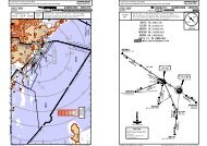
23.2DD5Licensed to max. Printed on 16 Feb 2008.NOTICE: PRINTED FROM AN EXPIRED REVISION. Disc 01-2008<strong>EGKK</strong>/LGWGATWICKD-ATIS136.52Apt Elev Alt Set: hPa202' Trans level: By ATC Trans alt: 6000'DHONILEYJEPPESENJeppView 3.5.2.0LONDON, UK14 SEP 07 20-2 .Eff.27.Sep..STAR.113.65 HONN52 21.4 W001 39.8156^ 1By ATCDISITN52 06.2W001 42.7133^211By ATCD1By ATC336^KIDLIN51 46.3 W001 21.7JEPPESEN180^32.2Enroute holding at DELBO:During periods of congestion inthe London TMA traffic from thenorth may be required to hold atDELBO. Traffic via airwaysA 34/UA 34 may be required toroute from DISIT to DELBO.Traffic via airway N 859 may berequired to route via HON toDELBO.MSAARP2300'090^ 270^ASTRA TWO BRAVO (ASTRA 2B) [ASTR2B]ASTRA ONE FOXTROT (ASTRA 1F)ASTRA TWO HOTEL (ASTRA 2H) [ASTR2H]ARRIVALSFROM NORTHTO BE USED WHEN MID VOR UNSERVICEABLEDELBON51 52.6W001 16.41[ASTR1F]WARNINGDo not proceed beyondASTRAwithout ATC clearance.SLP2200'Speed Limit Point2000'ASTRA 2B139^26KENETN51 31.2W001 27.3103^22161^26127^NIGITN51 18.8W001 10.331264^D17 SFD123^D33 SFDN51 02.5 W000 37.5WOODLEY352 WODASTRA 1FN51 27.2 W000 52.7106^15BEDEKN51 22.3W001 33.5165 16SLPD28 SFDSLPD28 SFDD12R303^ASTRAN50 51.9 W000 08.8DNOT TO SCALESEAFORDSFD 117.0 N50 45.6 E000 07.3D 117.9 MAYFIELDMAYN51 01.0 E000 07.0ASTRA 2H090^270^DESCENT PLANNINGPilots should plan for possible descentclearance as follows:ASTRA 2B: FL200 by DISIT,FL150 by KIDLIASTRA 1F: FL140 by KENETASTRA 2H: FL140 by BEDEKACTUAL DESCENT CLEARANCE WILLBE AS DIRECTED BY ATC.6000'3000'FL70CHANGES:ASTRA 1H renumbered 2H & revised; alt depiction.| JEPPESEN SANDERSON, INC., 2002, 2007. ALL RIGHTS RESERVED.Licensed to max. Printed on 16 Feb 2008.NOTICE: PRINTED FROM AN EXPIRED REVISION. Disc 01-2008<strong>EGKK</strong>/LGWGATWICKD-ATIS136.52JEPPESEN14 SEP 07 20-2A .Eff.27.Sep.Apt Elev Alt Set: hPa202' Trans level: By ATC Trans alt: 6000'ASTRA THREE ALFA (ASTRA 3A)JEPPESENJeppView 3.5.2.0LONDON, UK.STAR.090^ 270^R303^264^D12ASTRAN50 51.9W000 08.8091^180^360^D7.2R256^R288^KATHYN50 31.2 W001 20.0N50 51.3 W000 45.4SLPD17 SFD123^23ASTRA 3A108^R 8FL200D46.3258^MAA FL190R 8GIBSON50 45.0W002 31.1FL270D SOUTHAMPTON113.35 SAM SAMN50 57.3 W001 20.7AVANTN50 49.2 W000 56.3GWC114.75 GWCD GOODWOODSFD117.0 SFDDSEAFORDN50 45.6 E000 07.3MAY117.9 MAYD MAYFIELDN51 01.0 E000 07.0090^D5270^076^2330062^By ATC042^20ASTRA 4CBy ATCR 41MAA FL100BILNIN50 40.5 W002 07.6KUMILN50 34.5 W001 36.7DOMUTN50 15.7 W001 40.2ASTRA 3DBy ATC289^109^16 21DESCENT PLANNINGPilots should plan for possibledescent clearance as follows:ASTRA 3A: FL130 by GWCASTRA 4C: FL270 by DOMUTFL130 by GWCASTRA 3D: FL270 by GIBSOFL180 by KUMILFL130 by GWCACTUAL DESCENT CLEARANCEWILL BE AS DIRECTED BY ATC.FL200FL160FL2006000'3000'FL702200'2000'MSAARP2300'180^ARRIVALSFROM SOUTH & WESTTO BE USED WHEN MID VOR UNSERVICEABLE[ASTR3A]ASTRA FOUR CHARLIE (ASTRA 4C) [ASTR4C]ASTRA THREE DELTA (ASTRA 3D) [ASTR3D]NOT TO SCALEWARNINGDo not proceed beyondASTRAwithout ATC clearance.SLPSpeed Limit Point042^222^222^CHANGES:Altitude depiction.| JEPPESEN SANDERSON, INC., 2002, 2007. ALL RIGHTS RESERVED.
Licensed to max. Printed on 16 Feb 2008.NOTICE: PRINTED FROM AN EXPIRED REVISION. Disc 01-2008<strong>EGKK</strong>/LGWGATWICKD-ATIS136.52JEPPESEN14 SEP 07 20-2B .Eff.27.Sep.Apt Elev Alt Set: hPa202' Trans level: By ATC Trans alt: 6000'JEPPESENJeppView 3.5.2.0LONDON, UK.STAR.090^ 270^R111^D18.3291^D18.3/2515.1 D 9.7D24.8198^D8.5D45.5D17.2 254^DR061^D29D24.4R130^ D7BIGGIND115.1 BIGN51 19.9 E000 02.1TIMBA( 1 LUMBA)N50 56.7 E000 15.72DETLINGD117.3 DETN51 18.2 E000 35.89LARCKN50 54.7E000 26.8SPEARN51 34.6E000 42.0TRIPON51 42.8 E001 05.0TANETN51 27.0E000 55.5KOPULN51 32.5E001 08.2LOGANN51 44.9 E001 36.7MAA FL90237^TIMBA 1HLUMBA 1H 1241^TIMBA 2ELUMBA 2E 1 3R057^11196^R015^195^SLPD11 DET310^R131^D34.4OCKHAMD115.3 OCKN51 18.3 W000 26.8OCKHAMD115.3 OCKN51 18.3 W000 26.8MAY117.9 MAYD MAYFIELDN51 01.0 E000 07.02Aircraft positioning from EGSS.3 During periods of congestion inthe London TMA traffic may berequired to hold at LOGAN.CLN114.55 CLNDCLACTONN51 50.9 E001 08.9ERINGN51 35.4E001 36.7TEBRAN51 29.3E001 36.71L 98013.4(OCK R-131/D34.4)LYDDD 114.05 LYDN51 00.0 E000 52.716.516.8FL70FL70090^D5270^6000'3000'2200'2000'MSAARP2300'180^TIMBA TWO ECHO(TIMBA 2E) [TIMB2E]TIMBA ONE HOTEL(TIMBA 1H) [TIMB1H]ARRIVALSFROM NORTHWHEN MAY VOR OR DMEUNSERVICEABLE USELUMBA 2E [LUMB2E]LUMBA 1H [LUMB1H]311^1LUMBA 2ELUMBA 1HTo be used whenMAY VOR or DMEunserviceableLUMBAN50 56.7 E000 15.7WARNINGDo not proceed beyondTIMBA/LUMBAwithout ATC clearance.[LUMB2E][LUMB1H]NOT TO SCALEDESCENT PLANNINGPilots should plan for possibledescent clearance as follows:TIMBA 2E: FL220 by 5 NM beforeERING/TEBRA,FL130 by TANETTIMBA 1H: by ATCACTUAL DESCENT CLEARANCEWILL BE AS DIRECTED BY ATC.SLP Speed Limit PointCHANGES:Altitude depiction.| JEPPESEN SANDERSON, INC., 2002, 2007. ALL RIGHTS RESERVED.Licensed to max. Printed on 16 Feb 2008.NOTICE: PRINTED FROM AN EXPIRED REVISION. Disc 01-2008<strong>EGKK</strong>/LGWGATWICKD-ATIS136.52JEPPESEN14 SEP 07 20-2C .Eff.27.Sep.Apt Elev Alt Set: hPa202' Trans level: By ATC Trans alt: 6000'JEPPESENJeppView 3.5.2.0TIMBA TWO BRAVO (TIMBA 2B) [TIMB2B]TIMBA ONE DELTA (TIMBA 1D) [TIMB1D]LONDON, UK.STAR.090^ 270^120^196^ 117.3DETTED098^R130^ D7D30D17.2D24.4D15.9R131^D34.4OCKHAMD115.3 OCKN51 18.3 W000 26.8TIMBA( 1 LUMBA)N50 56.7 E000 15.7LARCKN50 54.7 E000 26.8HASTYN50 43.7E000 32.0 BEXILN50 42.5E000 44.2(OCK D57.4)GURLUN50 28.7 E000 58.1WHEN MAY VOR OR DME UNSERVICEABLE USE12330^310^16TIMBA 2BLUMBA 2B 1254^D12 MAYD39 OCKN50 57.1E000 24.9SLPD19 MAYSLPD24 MAYTIMBA 1FLUMBA 1F1512117OCKHAMD115.3 OCKN51 18.3 W000 26.8SLPD5 MAY R277^DSEAFORDMAY117.9 MAYD MAYFIELDN51 01.0 E000 07.0SFD117.0 SFDN50 45.6 E000 07.39TIMBA 1GLUMBA 1G 1LYDDD 114.05 LYDN51 00.0 E000 52.7D36 MAY310^12.22111^12090^270^23097^TIMBA 1DLUMBA 1D 125MID114.0 MIDD MIDHURSTN51 03.2 W000 37.526000'3000'(OCK R-131/D34.4)FL70FL190FL140D5By ATC. Not to be usedfor flight planning purposes.FL702200'2000'MSAARP2300'180^TIMBA ONE FOXTROT (TIMBA 1F) [TIMB1F]TIMBA ONE GOLF (TIMBA 1G) [TIMB1G]ARRIVALSFROM EAST, SOUTH & WESTLUMBA 2B [LUMB2B], LUMBA 1D [LUMB1D]LUMBA 1F [LUMB1F], LUMBA 1G [LUMB1G]311^1LUMBA 2BLUMBA 1DLUMBA 1FLUMBA 1GLUMBAN50 56.7 E000 15.7[LUMB2B][LUMB1D][LUMB1F][LUMB1G]To be used whenMAY VOR or DMEunserviceableWARNINGDo not proceed beyondTIMBA/LUMBAwithout ATC clearance.SLPSpeed Limit PointDESCENT PLANNINGPilots should plan for possibledescent clearance as follows:TIMBA 2B: FL150 by BEXILTIMBA 1D, 1F, 1G: by ATCACTUAL DESCENT CLEARANCEWILL BE AS DIRECTED BY ATC.NOT TO SCALECHANGES:Track updated; altitude depiction.| JEPPESEN SANDERSON, INC., 2002, 2007. ALL RIGHTS RESERVED.
SFDD5Licensed to max. Printed on 16 Feb 2008.NOTICE: PRINTED FROM AN EXPIRED REVISION. Disc 01-2008<strong>EGKK</strong>/LGWGATWICKD-ATIS136.52Apt Elev Alt Set: hPa202' Trans level: By ATC Trans alt: 6000'DHONILEY113.65 HONN52 21.4 W001 39.820-2DJEPPESENJeppView 3.5.2.0156^ 1DDD55.1R337^KENETN51 31.2W001 27.3KIDLIN51 46.3W001 21.7D135^D114.0 MIDHURSTMIDN51 03.2 W000 37.542D130^WILLO 1FNIGITN51 18.8W001 10.3205^R310^R315^263^D11.8D22.55R107^D16.9287^SLPD5 MIDDBIGGIN115.1 BIGN51 19.9 E000 02.1LONDON, UKD22.5HOLLY.STAR.32.2By ATC133^DISITN52 06.2 W001 42.72111By ATCBy ATC150^WILLO 3BR330^10HOLDING OVERMAY14 SEP 07.Eff.27.Sep.180^Enroute holding at DELBO:During periods of congestion inthe London TMA traffic from thenorth may be required to hold atDELBO. Traffic via airwaysA 34/UA 34 may be required toroute from DISIT to DELBO.Traffic via airway N 859 may berequired to route via HON toDELBO.51.2106^15BEDEKN51 22.3W001 33.5WILLO 2H25.8D16.9/22N50 53.2 W000 05.7D 117.9 MAYFIELDMAYN51 01.0 E000 07.0090^270^6000'3000'FL702200'2000'MSAARP2300'090^ 270^ARRIVALSFROM NORTHDELBON51 52.6W001 16.4JEPPESENWILLO THREE BRAVO (WILLO 3B)WILLO ONE FOXTROT (WILLO 1F) [WILO1F]WILLO TWO HOTEL (WILLO 2H) [WILO2H][WILO3B]NOT TO SCALEWILLON50 59.1W000 11.5119^WARNINGDo not proceed beyondWILLOwithout ATC clearance.SLPDESCENT PLANNINGPilots should plan for possible descentclearance as follows:WILLO 3B: FL200 by DISIT,FL150 by KIDLIWILLO 1F: FL140 by KENETWILLO 2H: FL140 BEDEKACTUAL DESCENT CLEARANCE WILLBE AS DIRECTED BY ATC.If MID VOR u/srefer to charts 20-2 & 20-2A117.5Speed Limit PointCHANGES:WILLO 1H renumbered 2H & revised; alt depiction.| JEPPESEN SANDERSON, INC., 2002, 2007. ALL RIGHTS RESERVED.Licensed to max. Printed on 16 Feb 2008.NOTICE: PRINTED FROM AN EXPIRED REVISION. Disc 01-2008<strong>EGKK</strong>/LGWGATWICKD-ATIS136.52JEPPESEN14 SEP 07 20-2E .Eff.27.Sep.Apt Elev Alt Set: hPa202' Trans level: By ATC Trans alt: 6000'JEPPESENJeppView 3.5.2.0LONDON, UK.STAR.090^ 270^HOLLYN50 53.2W000 05.7263^D11.8193^D27.1 115.1205^DD22.5BIG119^ D22.5D16.9GIB088^R107^287^WILLON50 59.1W000 11.5SFD117.0 SFDDSEAFORDN50 45.6 E000 07.3180^360^D41.9D18.4R223^DR256^23108^WILLO 3AR288^AVANTN50 49.2 W000 56.3D62.1D100.6 273^D46.3258^MAA FL190D SOUTHAMPTON113.35 SAM SAMN50 57.3 W001 20.7MID114.0 MIDD MIDHURSTN51 03.2 W000 37.5MAY117.9 MAYD MAYFIELDN51 01.0 E000 07.010D16.9/22R 8HOLDING OVERMAY090^270^25.2076^7.230043^By ATCBy ATC WILLO 4C062^BILNIN50 40.5 W002 07.6KUMILN50 34.5 W001 36.7DOMUTN50 15.7 W001 40.2KATHYN50 31.2 W001 20.020.223.5R 41MAA FL100109^16 21WILLO 2DBy ATC289^DESCENT PLANNINGPilots should plan for possibledescent clearance as follows:WILLO 3A: FL130 by GWCWILLO 4C: FL270 by DOMUTFL130 by GWCWILLO 2D: FL270 by GIBSOFL180 by KUMILFL130 by GWCACTUAL DESCENT CLEARANCEWILL BE AS DIRECTED BY ATC.FL200FL160FL200D5R 8FL200GIBSON50 45.0W002 31.1FL2706000'3000'GWC114.75 GWCD GOODWOODN50 51.3 W000 45.4SLPFL702200'2000'MSAARP2300'180^WILLO THREE ALFA (WILLO 3A) [WILO3A]WILLO FOUR CHARLIE (WILLO 4C) [WILO4C]WILLO TWO DELTA (WILLO 2D) [WILO2D]ARRIVALSFROM SOUTH & WESTNOT TO SCALESLPSpeed Limit PointWARNINGDo not proceed beyondWILLOwithout ATC clearance.refer to charts 20-2 & 20-2AIf MID VOR u/s043^CHANGES:Altitude depiction.| JEPPESEN SANDERSON, INC., 2002, 2007. ALL RIGHTS RESERVED.
Licensed to max. Printed on 16 Feb 2008.NOTICE: PRINTED FROM AN EXPIRED REVISION. Disc 01-2008<strong>EGKK</strong>/LGWGATWICKLONDONControl120.52Apt Elev202'14 SEP 07JEPPESEN20-3.Eff.27.Sep.JEPPESENJeppView 3.5.2.0LONDON, UKTrans level: By ATC Trans alt: 6000'1. When instructed contact LONDON Control. 2. SIDs include noise preferentialroutes (refer to 20-4). 3. Initial climb straight ahead to 710'.4. Cruising levels will be issued after take-off by LONDON Control.5. Do not climb above SID level until instructed by ATC.BIGGIN SEVEN MIKE (BIG 7M)BIGGIN SEVEN VICTOR (BIG 7V)RWYS 26L/R DEPARTURESTO EGLL & EGWU ONLYMAX 250 KT BELOW FL100SPEED:UNLESS OTHERWISE AUTHORIZEDWARNINGDue to interaction with other routes pilotsmust ensure strict compliance with thespecified climb profile unless cleared by ATC.2200'180^2000'MSAARP.SID.2300'090^ 270^Licensed to max. Printed on 16 Feb 2008.NOTICE: PRINTED FROM AN EXPIRED REVISION. Disc 01-2008<strong>EGKK</strong>/LGWGATWICKLONDONControl120.52Apt Elev202'JEPPESEN14 SEP 07 20-3A .Eff.27.Sep.JEPPESENJeppView 3.5.2.0LONDON, UKTrans level: By ATC Trans alt: 6000'1. When instructed contact LONDON Control. 2. SIDs include noise preferentialroutes (refer to 20-4). 3. Initial climb straight ahead to 710'.4. Cruising levels will be issued after take-off by LONDON Control.5. Do not climb above SID level until instructed by ATC.BIGGIN THREE PAPA (BIG 3P)BIGGIN THREE WHISKEY (BIG 3W)RWYS 08R/L DEPARTURESTO EGLL & EGWU ONLYMAX 250 KT BELOW FL100SPEED:UNLESS OTHERWISE AUTHORIZEDWARNINGDue to interaction with other routes pilotsmust ensure strict compliance with thespecified climb profile unless cleared by ATC.2200'180^MSAARP.SID.2300'090^ 270^2000'BIGGIND115.1 BIGN51 19.9 E000 02.1DDETLING117.3 DETN51 18.2 E000 35.8BIGGIND115.1 BIGN51 19.9 E000 02.1R112^8D31 DET081^2.3260^DMED2IWWILS DMEGATWICK(110.9) IWWN51 09.2 W000 11.5D29 DET4000'13.6R112^292^129^D7.6125^ACORNN51 15.3 E000 11.85000'D15.410R261^25D18 BIGN51 09.9 E000 26.06000'219^4080^080^1093^N51 10.1W000 02.4GATWICK338 GE GEN51 09.9 W000 04.114134^D14.624TUNBYN51 10.1 E000 19.56000'5000'122^D196.1D39.1292^R273^D33 DVRN51 10.1 E000 29.16000'DOVERDVRD 114.95 DVRN51 09.8 E001 21.6Cross Noise Monitoring Terminal (refer to 20-4)at a minimum of 1210' thereafter maintain aminimum climb gradient of 243' per NM (4%) to3000' due to Noise Abatement.Gnd speed-KT 75 100 150 200 250 300243' per NM 304 405 608 810 1013 1215SIDBIG 7MBIG 7VRWY26L26RCHANGES: Tracks updated; altitude depiction.NOT TO SCALEROUTINGStraight ahead to IWW 2.3 DME, turn RIGHT, intercept DET R-261inbound by D31 DET, cross D29 DET at or below 4000', to ACORN(D15.4 DET), cross at 5000', turn RIGHT, intercept BIG R-125 to D18BIG (DET R-219), cross at 6000', turn LEFT, intercept BIG R-112inbound to BIG.| JEPPESEN SANDERSON, INC., 2002, 2007. ALL RIGHTS RESERVED.Cross Noise Monitoring Terminal (refer to 20-4)at a minimum of 1210' thereafter maintain aminimum climb gradient of 243' per NM (4%) to3000' due to Noise Abatement.Additionally for runway 08L maintain a minimumclimb gradient of 334' per NM (5.5%) to 410'.Gnd speed-KT 75 100 150 200 250 300243' per NM 304 405 608 810 1013 1215334' per NM 418 557 835 1114 1392 1671SIDBIG 3PBIG 3WRWY08R08LCHANGES: Tracks updated; altitude depiction.NOT TO SCALEROUTINGStraight ahead via GE, maintain 080^ track, intercept DVR R-273inbound, cross TUNBY (D39.1 DVR) at or above 5000' (MAX 6000'),to D33 DVR (D19 BIG), cross at 6000', turn LEFT, intercept BIG R-112inbound to BIG.| JEPPESEN SANDERSON, INC., 2002, 2007. ALL RIGHTS RESERVED.
555Licensed to max. Printed on 16 Feb 2008.NOTICE: PRINTED FROM AN EXPIRED REVISION. Disc 01-2008<strong>EGKK</strong>/LGWGATWICKLONDONControl133.17Apt Elev202'OCKHAMD115.3 OCKN51 18.3 W000 26.8DMIDHURST114.0 MIDN51 03.2 W000 37.5DGWC114.75 GOODWOODN50 51.3 W000 45.4JEPPESEN14 SEP 07 20-3B .Eff.27.Sep.178^149^167^3118^2260^D28 OCKN50 50.5 W000 22.610D21.3D25.54260^365 GATWICKGYN51 07.8 W000 19.0BOGNAN50 42.1 W000 15.1JEPPESENJeppView 3.5.2.0LONDON, UKTrans level: By ATC Trans alt: 6000'1. When instructed contact LONDON Control. 2. SIDs include noise preferentialroutes (refer to 20-4). 3. Initial climb straight ahead to 710'.4. Cruising levels will be issued after take-off by LONDON Control.5. Do not climb above SID level until instructed by ATC.BOGNA ONE MIKE (BOGNA 1M) [BOGN1M]BOGNA ONE VICTOR (BOGNA 1V) [BOGN1V]RWYS 26L/R DEPARTURESSIDBOGNA 1MBOGNA 1VONLY AVAILABLE BETWEEN 0600-2300LTAT OTHER TIMES SIDS SFD 4M & 4V WILL BE ISSUEDD13 OCK5000'3000'CHANGES: Chart reindexed; altitude depiction.SPEED: MAX 250 KT BELOW FL100UNLESS OTHERWISE AUTHORIZEDWARNINGDue to interaction with other routes pilotsmust ensure strict compliance with thespecified climb profile unless cleared by ATC.Cross Noise Monitoring Terminal (refer to 20-4)at a minimum of 1210' thereafter maintain aminimum climb gradient of 243' per NM (4%) to3000' due to Noise Abatement.Gnd speed-KT 75 100 150 200 250 300243' per NM 304 405 608 810 1013 1215RWY26L26RD10.5 MIDN51 07.4 W000 22.25000'2500'D18 OCK5000'D23 OCK6000'2200'2000'MSAARP.SID.2300'090^ 270^NOT TO SCALEROUTINGStraight ahead via GY, maintain 260^ track to D10.5 MID, cross above2500' (MAX 5000'), turn LEFT, intercept OCK R-178, cross D13 OCKabove 3000' (MAX 5000'), D18 OCK at 5000', D23 OCK at 6000', toD28 OCK, turn LEFT, intercept MID R-149 to BOGNA.| JEPPESEN SANDERSON, INC., 2002, 2007. ALL RIGHTS RESERVED.180^Licensed to max. Printed on 16 Feb 2008.NOTICE: PRINTED FROM AN EXPIRED REVISION. Disc 01-2008<strong>EGKK</strong>/LGWGATWICKD13.3LONDONControl120.52R265^085^DAGGAN51 49.3 E000 47.7D32Apt Elev202'CLACTONCLNN51 50.9 E001 08.927D114.55 CLNBIGGIN115.1 BIGDD5 DETN51 19.9 E000 02.1ACORNN51 15.3 E000 11.8DETLINGD117.3 DETN51 18.2 E000 35.8015^5JEPPESEN14 SEP 07 20-3C .Eff.27.Sep.D15.4 R261^129^ D7.6D29 DETR186^006^613R279^2D31 DETD31 DVRN51 13.7 E000 32.7081^114.95 DVRDOVERDVRDILS DMEGATWICK(110.9) IWWD8N51 09.2 W000 11.5IWW260^N51 09.8 E001 21.6DME2.3JEPPESENJeppView 3.5.2.0LONDON, UKTrans level: By ATC Trans alt: 6000'1. When instructed contact LONDON Control. 2. SIDs include noise preferentialroutes (refer to 20-4). 3. Initial climb straight ahead to 710'.4. Cruising levels will be issued after take-off by LONDON Control.5. Do not climb above SID level until instructed by ATC.CLACTON EIGHT MIKE (CLN 8M)CLACTON EIGHT VICTOR (CLN 8V)RWYS 26L/R DEPARTURESFOR POSITIONING FLIGHTS TO EGGW & EGSSFOLLOW CLN SIDS TO DET, THEN JOINSTAR ABBOT 1E MAINTAINING 5000'SPEED: MAX 250 KT BELOW FL100UNLESS OTHERWISE AUTHORIZEDWARNINGDue to interaction with other routes pilotsmust ensure strict compliance with thespecified climb profile unless cleared by ATC.6000'5000'5000'4000'CHANGES: Tracks updated; chart reindexed; altitude depiction.NOT TO SCALE099^13.6Gnd speed-KT 75 100 150 200 250 300243' per NM 304 405 608 810 1013 1215180^Cross Noise Monitoring Terminal (refer to 20-4)at a minimum of 1210' thereafter maintain aminimum climb gradient of 243' per NM (4%) to3000' due to Noise Abatement..SID.MSAARP| JEPPESEN SANDERSON, INC., 2002, 2007. ALL RIGHTS RESERVED.2300'090^ 270^2200'SID RWYROUTING26L26RCLN 8MCLN 8V2000'Straight ahead to IWW 2.3 DME, turn RIGHT, intercept DET R-261 inbound by D31 DET, cross D29 DETat or below 4000', to ACORN (D15.4 DET), cross at 5000', turn RIGHT, intercept DVR R-279 inbound toD31 DVR, turn LEFT to DET, cross at 5000', turn RIGHT, DET R-015, cross D5 DET at 6000', to DAGGA,turn RIGHT, intercept CLN R-265 inbound to CLN.In order to alleviate airspace congestion pilots may be offered SIDs TIGER 2M/2V at a late stage of taxiing.Pilots unable to accept must inform ATC and will be allocated CLM 8M/8V.
Licensed to max. Printed on 16 Feb 2008.NOTICE: PRINTED FROM AN EXPIRED REVISION. Disc 01-2008<strong>EGKK</strong>/LGWGATWICKLONDONControl120.52Apt Elev202'2 NOV 07JEPPESEN20-3DJEPPESENJeppView 3.5.2.0LONDON, UKTrans level: By ATC Trans alt: 6000'1. When instructed contact LONDON Control. 2. SIDs include noise preferentialroutes (refer to 20-4). 3. Initial climb straight ahead to 710'.4. Cruising levels will be issued after take-off by LONDON Control.5. Do not climb above SID level until instructed by ATC..SID.090^ 270^DR273^D32DAGGAN51 49.3 E000 47.7D31 DVRN51 10.1 E000 32.3D13.1 234^D39.1134^D14.6BIGGIND115.1 BIGN51 19.9 E000 02.1093^GATWICK338 GE GEN51 09.9 W000 04.114TUNBYN51 10.1 E000 19.5DETLINGD117.3 DETN51 18.2 E000 35.8DOVERDVRD 114.95 DVRN51 09.8 E001 21.6085^R265^006^9R186^5015^27N51 10.1W000 02.4D5 DETCLACTONCLND 114.55 CLNN51 50.9 E001 08.913.35000'6000'8.15000'2200'2000'MSAARP2300'180^CLACTON FIVE PAPA (CLN 5P)CLACTON FIVE WHISKEY (CLN 5W)RWYS 08R/L DEPARTURESFOR POSITIONING FLIGHTS TO EGGW & EGSSFOLLOW CLN SIDS TO DET, THEN JOINSTAR ABBOT 1E MAINTAINING 5000'SPEED:MAX 250 KT BELOW FL100UNLESS OTHERWISE AUTHORIZEDNOT TO SCALESID RWYROUTINGCLN 5P 08R Straight ahead via GE, maintain 080^ track, interceptDVR R-273 inbound, cross TUNBY (D39.1 DVR)CLN 5W 08Lat 5000', to D31 DVR, turn LEFT to DET, cross at5000', turn RIGHT, DET R-015, cross D5 DET at6000', to DAGGA, turn RIGHT, intercept CLN R-265inbound to CLN.Cross Noise Monitoring Terminal (refer to 20-4)at a minimum of 1210' thereafter maintain aminimum climb gradient of 243' per NM (4%) to3000' due to Noise Abatement.Additionally for runway 08L maintain a minimumclimb gradient of 334' per NM (5.5%) to 410'.Gnd speed-KT 75 100 150 200 250 300243' per NM 304 405 608 810 1013 1215334' per NM 418 557 835 1114 1392 1671WARNINGDue to interaction with other routes pilotsmust ensure strict compliance with thespecified climb profile unless cleared by ATC.4080^080^1CHANGES:None.| JEPPESEN SANDERSON, INC., 2002, 2007. ALL RIGHTS RESERVED.Licensed to max. Printed on 16 Feb 2008.NOTICE: PRINTED FROM AN EXPIRED REVISION. Disc 01-2008<strong>EGKK</strong>/LGWGATWICKLONDONControl120.52Apt Elev202'2 NOV 07JEPPESEN20-3EJEPPESENJeppView 3.5.2.0LONDON, UKTrans level: By ATC Trans alt: 6000'1. When instructed contact LONDON Control. 2. SIDs include noise preferentialroutes (refer to 20-4). 3. Initial climb straight ahead to 710'.4. Cruising levels will be issued after take-off by LONDON Control.5. Do not climb above SID level until instructed by ATC.DOVER EIGHT MIKE (DVR 8M)DOVER EIGHT VICTOR (DVR 8V).SID.090^ 270^DOVERDVRD 114.95 DVRN51 09.8 E001 21.6225^D33 DVR099^ R279^D15.4R261^D44.211.233129^D7.6081^2D31 DETDBIGGIND115.1 BIGN51 19.9 E000 02.1IWW(110.9) IWWGATWICKILS DMEN51 09.2 W000 11.5D29 DET4000'ACORNN51 15.3 E000 11.85000'6000'DETLINGD117.3 DETN51 18.2 E000 35.82200'2000'MSAARP2300'180^RWYS 26L/R DEPARTURESIN ORDER TO ALLEVIATE AIRSPACE CONGESTIONAND IMPROVE ATC FLEXIBILITY PILOTS MAY BEOFFERED SIDS WIZAD 4M/4V AT A LATE STAGEPRIOR TO DEPARTUREPILOTS UNABLE TO ACCEPT MUST INFORMATC AND WILL BE ALLOCATED DVR 8M/8VSPEED:MAX 250 KT BELOW FL100UNLESS OTHERWISE AUTHORIZEDWARNINGDue to interaction with other routes pilotsmust ensure strict compliance with thespecified climb profile unless cleared by ATC.Cross Noise Monitoring Terminal (refer to 20-4)at a minimum of 1210' thereafter maintain aminimum climb gradient of 243' per NM (4%) to3000' due to Noise Abatement.Gnd speed-KT 75 100 150 200 250 300243' per NM 304 405 608 810 1013 1215NOT TO SCALESID RWYROUTINGDVR 8M 26L Straight ahead to IWW 2.3 DME, turn RIGHT, intercept DETDVR 8V 26R R-261 inbound by D31 DET, cross D29 DET at or below 4000',to ACORN (D15.4 DET), cross at 5000', turn RIGHT, interceptDVR R-279 inbound, cross D33 DVR at 6000', to DVR.13.6260^DME2.38CHANGES:Text description.| JEPPESEN SANDERSON, INC., 2002, 2007. ALL RIGHTS RESERVED.
555Licensed to max. Printed on 16 Feb 2008.NOTICE: PRINTED FROM AN EXPIRED REVISION. Disc 01-2008<strong>EGKK</strong>/LGWGATWICKLONDONControl120.52180^2300'090^ 270^2200'DETLINGD117.3 DETN51 18.2 E000 35.8BIGGIN115.1 BIGDN51 19.9 E000 02.12000'Apt Elev202'MSAARPD114.95 DVRN51 09.8 E001 21.6DOVERDVR134^212^D14.6080^6.1D39.1141R273^33093^4N51 10.1W000 02.4CHANGES: SIDs transferred; altitude depiction.080^JEPPESEN14 SEP 07 20-3F .Eff.27.Sep.D33 DVRTUNBYN51 10.1 E000 19.5GATWICK338 GE GEN51 09.9 W000 04.1JEPPESENJeppView 3.5.2.0LONDON, UKTrans level: By ATC Trans alt: 6000'1. When instructed contact LONDON Control. 2. SIDs include noise preferentialroutes (refer to 20-4). 3. Initial climb straight ahead to 710'.4. Cruising levels will be issued after take-off by LONDON Control.5. Do not climb above SID level until instructed by ATC.6000'DOVER TWO PAPA (DVR 2P)DOVER TWO WHISKEY (DVR 2W)RWYS 08R/L DEPARTURES6000'5000'SPEED: MAX 250 KT BELOW FL100UNLESS OTHERWISE AUTHORIZEDWARNINGDue to interaction with other routes pilotsmust ensure strict compliance with thespecified climb profile unless cleared by ATC.NOT TO SCALECross Noise Monitoring Terminal (refer to 20-4)at a minimum of 1210' thereafter maintain aminimum climb gradient of 243' per NM (4%) to3000' due to Noise Abatement.Additionally for runway 08L maintain a minimumclimb gradient of 334' per NM (5.5%) to 410'.Gnd speed-KT 75 100 150 200 250 300243' per NM 304 405 608 810 1013 1215334' per NM 418 557 835 1114 1392 1671SID RWYROUTING.SID.Straight ahead via GE, maintain 080^ track, interceptDVR R-273 inbound, cross TUNBY (D39.1 DVR) at orabove 5000' (MAX 6000'), D33 DVR at 6000', to DVR.08R08LDVR 2PDVR 2W| JEPPESEN SANDERSON, INC., 2002, 2007. ALL RIGHTS RESERVED.Licensed to max. Printed on 16 Feb 2008.NOTICE: PRINTED FROM AN EXPIRED REVISION. Disc 01-2008<strong>EGKK</strong>/LGWGATWICKLONDONControl133.17Apt Elev202'OCKHAMD115.3 OCKN51 18.3 W000 26.8DMIDHURST114.0 MIDN51 03.2 W000 37.5JEPPESEN14 SEP 07 20-3G .Eff.27.Sep.178^149^167^118^D28 OCKN50 50.5 W000 22.6D21.3D25.5BOGNAN50 42.1 W000 15.1JEPPESENJeppView 3.5.2.0Trans level: By ATC Trans alt: 6000'1. When instructed contact LONDON Control. 2. SIDs include noise preferentialroutes (refer to 20-4). 3. Initial climb straight ahead to 710'.4. Cruising levels will be issued after take-off by LONDON Control.5. Do not climb above SID level until instructed by ATC.HARDY FIVE MIKE (HARDY 5M) [HARD5M]HARDY FIVE VICTOR (HARDY 5V) [HARD5V]RWYS 26L/R DEPARTURESSIDHARDY 5MHARDY 5VONLY AVAILABLE BETWEEN 0600-2300LTAT OTHER TIMES SIDS SFD 4M & 4V WILL BE ISSUEDSPEED: MAX 250 KT BELOW FL100UNLESS OTHERWISE AUTHORIZEDWARNINGDue to interaction with other routes pilotsmust ensure strict compliance with thespecified climb profile unless cleared by ATC.D13 OCK5000'3000'DGWC114.75 GOODWOODN50 51.3 W000 45.4CHANGES: Chart reindexed; altitude depiction.3D10.5 MIDN51 07.4 W000 22.25000'2500'2260^Cross Noise Monitoring Terminal (refer to 20-4)at a minimum of 1210' thereafter maintain aminimum climb gradient of 243' per NM (4%) to3000' due to Noise Abatement.Gnd speed-KT 75 100 150 200 250 300243' per NM 304 405 608 810 1013 1215RWY26L26R104260^365 GATWICKGYN51 07.8 W000 19.0D18 OCK5000'D23 OCK6000'31.6143^ D22.4D52.9LONDON, UK.SID.HARDYN50 28.3E000 29.5| JEPPESEN SANDERSON, INC., 2002, 2007. ALL RIGHTS RESERVED.D2200'2000'MSAARPSEAFORDSFD117.0 SFD2300'090^ 270^NOT TO SCALEN50 45.6 E000 07.3ROUTINGStraight ahead via GY, maintain 260^ track to D10.5 MID, cross above2500' (MAX 5000'), turn LEFT, intercept OCK R-178, cross D13 OCKabove 3000' (MAX 5000'), D18 OCK at 5000', D23 OCK at 6000', toD28 OCK, turn LEFT, intercept MID R-149 to BOGNA, intercept GWCR-118 to HARDY.180^
Licensed to max. Printed on 16 Feb 2008.NOTICE: PRINTED FROM AN EXPIRED REVISION. Disc 01-2008<strong>EGKK</strong>/LGWGATWICKLONDONControl134.12Apt Elev202'JEPPESEN14 SEP 07 20-3H .Eff.27.Sep.JEPPESENJeppView 3.5.2.0LONDON, UKTrans level: By ATC Trans alt: 6000'1. When instructed contact LONDON Control. 2. SIDs include noise preferentialroutes (refer to 20-4). 3. Initial climb straight ahead to 710'.4. Cruising levels will be issued after take-off by LONDON Control.5. Do not climb above SID level until instructed by ATC..SID.Licensed to max. Printed on 16 Feb 2008.NOTICE: PRINTED FROM AN EXPIRED REVISION. Disc 01-2008<strong>EGKK</strong>/LGWGATWICKLONDONControl134.12Apt Elev202'JEPPESEN14 SEP 07 20-3J .Eff.27.Sep.JEPPESENJeppView 3.5.2.0LONDON, UKTrans level: By ATC Trans alt: 6000'1. When instructed contact LONDON Control. 2. SIDs include noise preferentialroutes (refer to 20-4). 3. Initial climb straight ahead to 710'.4. Cruising levels will be issued after take-off by LONDON Control.5. Do not climb above SID level until instructed by ATC..SID.KENET TWO MIKE (KENET 2M) [KENE2M]KENET TWO VICTOR (KENET 2V) [KENE2V]RWYS 26L/R DEPARTURESRESTRICTED TO TRAFFIC WITH DESTINATIONS IN UK OR EIRESPEED: MAX 250 KT BELOW FL100UNLESS OTHERWISE AUTHORIZED2200'180^2000'MSAARP2300'090^ 270^KENET THREE PAPA (KENET 3P) [KENE3P]KENET THREE WHISKEY (KENET 3W) [KENE3W]RWYS 08R/L DEPARTURESRESTRICTED TO TRAFFIC WITH DESTINATIONS IN UK OR EIRESPEED: MAX 250 KT BELOW FL100UNLESS OTHERWISE AUTHORIZED2200'180^2000'MSAARP2300'090^ 270^WARNINGDue to interaction with other routes pilotsmust ensure strict compliance with thespecified climb profile unless cleared by ATC.WARNINGDue to interaction with other routes pilotsmust ensure strict compliance with thespecified climb profile unless cleared by ATC.KENETN51 31.2 W001 27.3(113.6 LON R-276/D37.1)D47.9SIDKENET 2MKENET 2V39329^DGWC114.75 GOODWOODN50 51.3 W000 45.4RWY26L26R10D10 MIDN51 01.1W000 53.04000'D8 MIDN51 06.7 W000 27.04000'3000'261^Cross Noise Monitoring Terminal (refer to 20-4)at a minimum of 1210' thereafter maintain aminimum climb gradient of 243' per NM (4%) to3000' due to Noise Abatement.Gnd speed-KT 75 100 150 200 250 300243' per NM 304 405 608 810 1013 1215CHANGES: Chart reindexed; SIDs transferred; altitude depiction.DMIDHURSTR066^114.0 MIDN51 03.2 W000 37.58246^D10 MID4000'2500'3 3260^4260^365 GATWICKGYN51 07.8 W000 19.0NOT TO SCALEROUTINGStraight ahead via GY, maintain 260^ track, cross D10 MID above 2500'(MAX 4000'), intercept MID R-066 inbound at D8 MID, cross above 3000'(MAX 4000'), to MID, cross at 4000', MID R-261 to D10 MID, turnRIGHT, intercept GWC R-329 to KENET.| JEPPESEN SANDERSON, INC., 2002, 2007. ALL RIGHTS RESERVED.KENETN51 31.2 W001 27.3D47.9(113.6 LON R-276/D37.1)33R070^SAM329^113.35 SAMD SOUTHAMPTONN50 57.3 W001 20.7D43 DETN51 10.4 W000 31.44000'13D20 SAMN51 05.2W000 51.6DGWC114.75 GOODWOODN50 51.3 W000 45.4CHANGES: SIDs transferred; altitude depiction.250^D33Cross Noise Monitoring Terminal (refer to 20-4)at a minimum of 1210' thereafter maintain aminimum climb gradient of 243' per NM (4%) to3000' due to Noise Abatement.Additionally for runway 08L maintain a minimumclimb gradient of 334' per NM (5.5%) to 410'.Gnd speed-KT 75 100 150 200 250 300243' per NM 304 405 608 810 1013 1215334' per NM 418 557 835 1114 1392 1671SIDKENET 3PKENET 3WRWY08R08LD36 DET3000'7 10DD26 DET3000'2500'8080^ILS DMEGATWICKIGG3(110.9) IGGDMEN51 09.2 W000 11.5NOT TO SCALE117.3DET262^ DETROUTINGStraight ahead to IGG 3 DME, turn LEFT, intercept DET R-262, crossD26 DET at or above 2500' (MAX 3000'), D36 DET at 3000', D43 DET(D33 SAM) at 4000', intercept SAM R-070 inbound to D20 SAM, turnRIGHT, intercept GWC R-329 to KENET.| JEPPESEN SANDERSON, INC., 2002, 2007. ALL RIGHTS RESERVED.
Licensed to max. Printed on 16 Feb 2008.NOTICE: PRINTED FROM AN EXPIRED REVISION. Disc 01-2008<strong>EGKK</strong>/LGWGATWICKLONDONControl133.17Apt Elev202'DJEPPESEN14 SEP 07 20-3K .Eff.27.Sep.JEPPESENJeppView 3.5.2.0LONDON, UKTrans level: By ATC Trans alt: 6000'1. When instructed contact LONDON Control. 2. SIDs include noise preferentialroutes (refer to 20-4). 3. Initial climb straight ahead to 710'.4. Cruising levels will be issued after take-off by LONDON Control.5. Do not climb above SID level until instructed by ATC.LAMBOURNE FOUR MIKE (LAM 4M)LAMBOURNE FOUR VICTOR (LAM 4V)RWYS 26L/R DEPARTURESIN ORDER TO ALLEVIATE AIRSPACE CONGESTIONS PILOTS MAY BEOFFERED SIDS TIGER 2M/2V AT A LATE STAGE OF TAXIINGPILOTS UNABLE TO ACCEPT MUST INFORM ATCAND WILL BE ALLOCATED LAM 4M/4VSPEED: MAX 250 KT BELOW FL100UNLESS OTHERWISE AUTHORIZEDWARNINGDue to interaction with other routes pilotsmust ensure strict compliance with thespecified climb profile unless cleared by ATC.LAMBOURNE115.6 LAMN51 38.8 E000 09.1BIGGIND115.1 BIGN51 19.9 E000 02.1R159^6000'10 511D10 LAM6000'D15 LAM5000'D2200'2000'MSAARPDETLING180^117.3 DET.SID.2300'090^ 270^NOT TO SCALEN51 18.2 E000 35.8Licensed to max. Printed on 16 Feb 2008.NOTICE: PRINTED FROM AN EXPIRED REVISION. Disc 01-2008<strong>EGKK</strong>/LGWGATWICKLONDONControl133.17Apt Elev202'LAMBOURNED 115.6 LAMN51 38.8 E000 09.1JEPPESEN14 SEP 07 20-3L .Eff.27.Sep.BIGGIND115.1 BIGN51 19.9 E000 02.1R159^178^10 511339^D15 LAMJEPPESENJeppView 3.5.2.0DLONDON, UKDETLING117.3 DETN51 18.2 E000 35.8.SID.Trans level: By ATC Trans alt: 6000'1. When instructed contact LONDON Control. 2. SIDs include noise preferentialroutes (refer to 20-4). 3. Initial climb straight ahead to 710'.4. Cruising levels will be issued after take-off by LONDON Control.5. Do not climb above SID level until instructed by ATC.LAMBOURNE FIVE PAPA (LAM 5P)LAMBOURNE FIVE WHISKEY (LAM 5W)RWYS 08R/L DEPARTURESSPEED: MAX 250 KT BELOW FL100UNLESS OTHERWISE AUTHORIZEDWARNINGDue to interaction with other routes pilotsmust ensure strict compliance with thespecified climb profile unless cleared by ATC.6000'D10 LAM6000'5000'2200'MSAARP2300'090^ 270^NOT TO SCALE180^2000'8D31 DET081^2.3260^DMESIDLAM 4MLAM 4V2DD29 DET4000'IWW13.6ILS DMEGATWICK(110.9) IWWN51 09.2 W000 11.5RWY26L26R129^ D7.6ACORNN51 15.3 E000 11.85000'CHANGES: Communications; SIDs transferred; altitude depiction.178^D23.55.4D15.4339^D10 DETN51 16.3E000 20.2R261^Cross Noise Monitoring Terminal (refer to 20-4)at a minimum of 1210' thereafter maintain aminimum climb gradient of 243' per NM (4%) to3000' due to Noise Abatement.Gnd speed-KT 75 100 150 200 250 300243' per NM 304 405 608 810 1013 1215ROUTINGStraight ahead to IWW 2.3 DME, turn RIGHT, intercept DET R-261inbound by D31 DET, cross D29 DET at or below 4000', ACORN (D15.4DET) at 5000', at D10 DET turn LEFT, intercept LAM R-159 inbound,cross D15 LAM at 5000', D10 LAM at 6000', to LAM, cross at 6000'.| JEPPESEN SANDERSON, INC., 2002, 2007. ALL RIGHTS RESERVED.DIGGILS DMEGATWICK(110.9) IGGN51 09.2 W000 11.5SIDLAM 5PLAM 5W080^DME3.5RWY08R08L11052^D20 DET081^129^D7.64.6 5.4D15.4ACORNN51 15.3 E000 11.85000'CHANGES: Communications; SIDs transferred; altitude depiction.D10 DETN51 16.3E000 20.2R261^Cross Noise Monitoring Terminal (refer to 20-4)at a minimum of 1210' thereafter maintain aminimum climb gradient of 243' per NM (4%) to3000' due to Noise Abatement.Additionally for runway 08L maintain a minimumclimb gradient of 334' per NM (5.5%) to 410'.Gnd speed-KT 75 100 150 200 250 300243' per NM 304 405 608 810 1013 1215334' per NM 418 557 835 1114 1392 1671ROUTINGStraight ahead to IGG 3.5 DME, turn LEFT, 052^ track, intercept DETR-261 inbound by D20 DET, cross ACORN (D15.4 DET) at 5000',at D10 DET turn LEFT, intercept LAM R-159 inbound, cross D15 LAM at5000', D10 LAM at 6000', to LAM, cross at 6000'.| JEPPESEN SANDERSON, INC., 2005, 2007. ALL RIGHTS RESERVED.D23.5
R313^Licensed to max. Printed on 16 Feb 2008.NOTICE: PRINTED FROM AN EXPIRED REVISION. Disc 01-2008<strong>EGKK</strong>/LGWGATWICKLONDONControl134.12Apt Elev202'JEPPESEN14 SEP 07 20-3M .Eff.27.Sep.JEPPESENJeppView 3.5.2.0LONDON, UKTrans level: By ATC Trans alt: 6000'1. When instructed contact LONDON Control. 2. SIDs include noise preferentialroutes (refer to 20-4). 3. Initial climb straight ahead to 710'.4. Cruising levels will be issued after take-off by LONDON Control.5. Do not climb above SID level until instructed by ATC.SEAFORD FOUR MIKE (SFD 4M)SEAFORD FOUR VICTOR (SFD 4V)RWYS 26L/R DEPARTURESNORMALLY NOT AVAILABLE BETWEEN 0600-2300LTAT THESE TIMES BOGNA OR HARDY SIDS WILL BE ISSUED AS APPROPRIATESPEED: MAX 250 KT BELOW FL100UNLESS OTHERWISE AUTHORIZEDWARNINGDue to interaction with other routes pilotsmust ensure strict compliance with thespecified climb profile unless cleared by ATC.2200'180^2000'MSAARP.SID.2300'090^ 270^Licensed to max. Printed on 16 Feb 2008.NOTICE: PRINTED FROM AN EXPIRED REVISION. Disc 01-2008<strong>EGKK</strong>/LGWGATWICK*GATWICKDirector118.95Apt Elev202'JEPPESEN14 SEP 07 20-3N .Eff.27.Sep.JEPPESENJeppView 3.5.2.0LONDON, UK.SID.Trans level: By ATC Trans alt: 6000'1. When instructed contact GATWICK Director. 2. SIDs include noise preferentialroutes (refer to 20-4). 3. Initial climb straight ahead to 710'.4. Cruising levels will be issued after take-off by LONDON Control.5. Do not climb above SID level until instructed by ATC.SEAFORD EIGHT PAPA (SFD 8P)SEAFORD EIGHT WHISKEY (SFD 8W)RWYS 08R/L DEPARTURESSPEED: MAX 250 KT BELOW FL100UNLESS OTHERWISE AUTHORIZEDWARNINGDue to interaction with other routes pilotsmust ensure strict compliance with thespecified climb profile unless cleared by ATC.2200'180^MSAARP2300'090^ 270^2000'DD6.8 IWWN51 07.2 W000 23.54000'2500'MIDHURST114.0 MIDN51 03.2 W000 37.57100^D25 SFD4000'365 GATWICKGYN51 07.8 W000 19.0260^2320^133^4260^DIWWILS DMEGATWICK(110.9) IWWN51 09.2 W000 11.5DIGGILS DMEGATWICK(110.9) IGGN51 09.2 W000 11.5080^2.5DMED21 SFD6000'2000'D17 SFD6000'3000'165^D14 SFD6000'4000'74286^7246^D117.9 MAYFIELDMAYN51 01.0 E000 07.03 79 16D16 SFD6000'NOT TO SCALENOT TO SCALED7 SFD6000'R345^Cross Noise Monitoring Terminal (refer to 20-4)at a minimum of 1210' thereafter maintain aminimum climb gradient of 243' per NM (4%) to3000' due to Noise Abatement.Gnd speed-KT 75 100 150 200 250 300243' per NM 304 405 608 810 1013 1215SIDSFD 4MSFD 4VCHANGES: New chart.RWY26L26RSEAFORDD117.0 SFDN50 45.6 E000 07.3ROUTINGStraight ahead via GY, maintain 260^ track until passing SFD R-320(D6.8 IWW), cross above 2500' (MAX 4000'), turn LEFT, intercept SFDR-313 inbound, cross D25 SFD at 4000', D16 SFD at 6000', to SFD.| JEPPESEN SANDERSON, INC., 2007. ALL RIGHTS RESERVED.Cross Noise Monitoring Terminal (refer to 20-4)at a minimum of 1210' thereafter maintain aminimum climb gradient of 243' per NM (4%) to3000' due to Noise Abatement.Additionally for runway 08L maintain a minimumclimb gradient of 334' per NM (5.5%) to 410'.Gnd speed-KT 75 100 150 200 250 300243' per NM 304 405 608 810 1013 1215334' per NM 418 557 835 1114 1392 1671SIDSFD 8PSFD 8WRWY08R08LCHANGES: New chart.SEAFORDD117.0 SFDN50 45.6 E000 07.3ROUTINGStraight ahead to IGG 2.5 DME, turn RIGHT, intercept SFD R-345 inbound,cross D21 SFD above 2000' (MAX 6000'), D17 SFD above 3000'(MAX 6000'), D14 SFD above 4000' (MAX 6000'), D7 SFD at 6000', to SFD.| JEPPESEN SANDERSON, INC., 2007. ALL RIGHTS RESERVED.
Licensed to max. Printed on 16 Feb 2008.NOTICE: PRINTED FROM AN EXPIRED REVISION. Disc 01-2008<strong>EGKK</strong>/LGWGATWICKLONDONControl134.12Apt Elev202'JEPPESEN14 SEP 07 20-3P .Eff.27.Sep.JEPPESENJeppView 3.5.2.0LONDON, UKTrans level: By ATC Trans alt: 6000'1. When instructed contact LONDON Control. 2. SIDs include noise preferentialroutes (refer to 20-4). 3. Initial climb straight ahead to 710'.4. Cruising levels will be issued after take-off by LONDON Control.5. Do not climb above SID level until instructed by ATC.SOUTHAMPTON TWO MIKE (SAM 2M)SOUTHAMPTON TWO VICTOR (SAM 2V)RWYS 26L/R DEPARTURESSPEED: MAX 250 KT BELOW FL100UNLESS OTHERWISE AUTHORIZEDWARNINGDue to interaction with other routes pilotsmust ensure strict compliance with thespecified climb profile unless cleared by ATC.2200'180^2000'MSAARP.SID.2300'090^ 270^Licensed to max. Printed on 16 Feb 2008.NOTICE: PRINTED FROM AN EXPIRED REVISION. Disc 01-2008<strong>EGKK</strong>/LGWGATWICKLONDONControl134.12Apt Elev202'JEPPESEN14 SEP 07 20-3Q .Eff.27.Sep.JEPPESENJeppView 3.5.2.0Trans level: By ATC Trans alt: 6000'1. When instructed contact LONDON Control. 2. SIDs include noise preferentialroutes (refer to 20-4). 3. Initial climb straight ahead to 710'.4. Cruising levels will be issued after take-off by LONDON Control.5. Do not climb above SID level until instructed by ATC.SOUTHAMPTON THREE PAPA (SAM 3P)SOUTHAMPTON THREE WHISKEY (SAM 3W)RWYS 08R/L DEPARTURESSPEED: MAX 250 KT BELOW FL100UNLESS OTHERWISE AUTHORIZEDWARNINGDue to interaction with other routes pilotsmust ensure strict compliance with thespecified climb profile unless cleared by ATC.LONDON, UK2200'180^MSAARP.SID.2300'090^ 270^2000'R081^SAM113.35 SAMD SOUTHAMPTONN50 57.3 W001 20.7284000'D8 MIDN51 06.7 W000 27.04000'3000'261^DMIDHURSTR066^114.0 MIDN51 03.2 W000 37.58246^D10 MID4000'2500'3 3260^4260^365 GATWICKGYN51 07.8 W000 19.0SAM113.35 SAMD SOUTHAMPTON33D43 DETN51 10.4 W000 31.44000'R070^ 250^N50 57.3 W001 20.7DD36 DET3000'7 10DD26 DET3000'2500'8080^ILS DMEGATWICKIGG3(110.9) IGGDMEN51 09.2 W000 11.5117.3DET262^ DETCross Noise Monitoring Terminal (refer to 20-4)at a minimum of 1210' thereafter maintain aminimum climb gradient of 243' per NM (4%) to3000' due to Noise Abatement.Gnd speed-KT 75 100 150 200 250 300243' per NM 304 405 608 810 1013 1215SIDSAM 2MSAM 2VCHANGES: New chart.RWY26L26RNOT TO SCALEROUTINGStraight ahead via GY, maintain 260^ track, cross D10 MID above 2500'(MAX 4000'), intercept MID R-066 inbound at D8 MID, cross above 3000'(MAX 4000'), to MID, cross at 4000', MID R-261 to SAM.| JEPPESEN SANDERSON, INC., 2007. ALL RIGHTS RESERVED.Cross Noise Monitoring Terminal (refer to 20-4)at a minimum of 1210' thereafter maintain aminimum climb gradient of 243' per NM (4%) to3000' due to Noise Abatement.Additionally for runway 08L maintain a minimumclimb gradient of 334' per NM (5.5%) to 410'.Gnd speed-KT 75 100 150 200 250 300243' per NM 304 405 608 810 1013 1215334' per NM 418 557 835 1114 1392 1671SIDSAM 3PSAM 3WCHANGES: New chart.RWY08R08LNOT TO SCALEROUTINGStraight ahead to IGG 3 DME, turn LEFT, intercept DET R-262, crossD26 DET at or above 2500' (MAX 3000'), D36 DET at 3000', D43 DET(D33 SAM) at 4000', intercept SAM R-070 inbound to SAM.| JEPPESEN SANDERSON, INC., 2007. ALL RIGHTS RESERVED.
Licensed to max. Printed on 16 Feb 2008.NOTICE: PRINTED FROM AN EXPIRED REVISION. Disc 01-2008<strong>EGKK</strong>/LGWGATWICKLONDONControl134.12Apt Elev202'JEPPESEN14 SEP 07 20-3S .Eff.27.Sep.JEPPESENJeppView 3.5.2.0LONDON, UKTrans level: By ATC Trans alt: 6000'1. When instructed contact LONDON Control. 2. SIDs include noise preferentialroutes (refer to 20-4). 3. Initial climb straight ahead to 710'.4. Cruising levels will be issued after take-off by LONDON Control.5. Do not climb above SID level until instructed by ATC..SID.Licensed to max. Printed on 16 Feb 2008.NOTICE: PRINTED FROM AN EXPIRED REVISION. Disc 01-2008<strong>EGKK</strong>/LGWGATWICK*GATWICKDirector118.95Apt Elev202'JEPPESEN14 SEP 07 20-3T .Eff.27.Sep.JEPPESENJeppView 3.5.2.0LONDON, UK.SID.Trans level: By ATC Trans alt: 6000'1. When instructed contact GATWICK Director. 2. SIDs include noise preferentialroutes (refer to 20-4). 3. Initial climb straight ahead to 710'.4. Cruising levels will be issued after take-off by LONDON Control.5. Do not climb above SID level until instructed by ATC.7D2.3 DME106^TIGER TWO MIKE (TIGER 2M) [TIGE2M]TIGER TWO VICTOR (TIGER 2V) [TIGE2V]RWYS 26L/R DEPARTURESILS DMEGATWICKIWW(110.9) IWWN51 09.2 W000 11.5SIDTIGER 2MTIGER 2V260^D13 MAYCHANGES: New chart.NOT TO BE USED FOR FLIGHT PLANNING PURPOSESSPEED: MAX 250 KT BELOW FL100UNLESS OTHERWISE AUTHORIZED4 9D9 MAY5000'3000'RWY26L26RWARNINGDue to interaction with other routes do notclimb above 5000' unless cleared by ATC.LAM115.6 LAMD LAMBOURNEN51 38.8 E000 09.1NOT TO SCALED117.9 MAYFIELDMAYN51 01.0 E000 07.0R286^5000'078^Cross Noise Monitoring Terminal (refer to 20-4)at a minimum of 1210' thereafter maintain aminimum climb gradient of 243' per NM (4%) to3000' due to Noise Abatement.Gnd speed-KT 75 100 150 200 250 300243' per NM 304 405 608 810 1013 1215R159^12.6TIGER 2MD39339^DAGGAN51 49.3E000 47.716R195^015^D32015^TIGER 2VD085^ R265^D2200'13.3CLACTONCLND 114.55 CLNN51 50.9 E001 08.9DETLING117.3 DETN51 18.2 E000 35.8TIGERN51 04.0 E000 26.45000'2000'MSAARP2300'090^ 270^TIGER SIDs are tactical routingsallocated by ATC to alleviate airspacecongestion.Pilots unable to accept TIGERSIDs when offered must informATC and will be reallocated CLNor LAM SIDs as appropriate.ROUTINGStraight ahead to IWW 2.3 DME, turn LEFT, intercept MAY R-286 inboundby D13 MAY, cross D9 MAY at or above 3000' (MAX 5000'), to MAY,cross at 5000', turn LEFT, MAY R-078 to TIGER, cross at 5000', turnLEFT, intercept LAM R-159 inbound to LAM.Straight ahead to IWW 2.3 DME, turn LEFT, intercept MAY R-286 inboundby D13 MAY, cross D9 MAY at or above 3000' (MAX 5000'), to MAY,cross at 5000', turn LEFT, MAY R-078 to TIGER, cross at 5000', turnLEFT, intercept DET R-195 inbound to DET, then to DAGGA, then to CLN.| JEPPESEN SANDERSON, INC., 2007. ALL RIGHTS RESERVED.180^7D2.3 DME106^WIZAD FOUR MIKE (WIZAD 4M) [WIZA4M]WIZAD FOUR VICTOR (WIZAD 4V) [WIZA4V]RWYS 26L/R DEPARTURESIWWILS DMEGATWICK(110.9) IWWN51 09.2 W000 11.5260^SIDWIZAD 4MWIZAD 4VD13 MAYCHANGES: New chart.WIZAD SIDS ARE TACTICAL ROUTINGS ALLOCATEDBY ATC TO ALLEVIATE AIRSPACE CONGESTIONPILOTS UNABLE TO ACCEPT WIZAD SIDS WHEN OFFEREDMUST INFORM ATC AND WILL BE REALLOCATED DVR SIDSNOT TO BE USED FOR FLIGHT PLANNING PURPOSESSPEED: MAX 250 KT BELOW FL100UNLESS OTHERWISE AUTHORIZEDWARNINGDue to interaction with other routes do notclimb above 6000' unless cleared by ATC.4 9D9 MAY6000'3000'RWY26L26RD117.9 MAYFIELDMAYN51 01.0 E000 07.0R286^6000'5000'081^Cross Noise Monitoring Terminal (refer to 20-4)at a minimum of 1210' thereafter maintain aminimum climb gradient of 243' per NM (4%) to3000' due to Noise Abatement.Gnd speed-KT 75 100 150 200 250 300243' per NM 304 405 608 810 1013 121512.8 19.4D35 DVR6000'D32.22200'D15.6WIZADN51 07.0E000 57.26000'NOT TO SCALE2000'MSAARP2300'090^ 270^DVRDVR114.95R261^ROUTINGStraight ahead to IWW 2.3 DME, turn LEFT, intercept MAY R-286inbound by D13 MAY, cross D9 MAY at or above 3000' (MAX 6000'),to MAY, cross at or above 5000' (MAX 6000'), turn LEFT, intercept DVRR-261 inbound, cross D35 DVR at 6000', to WIZAD, cross at 6000'.| JEPPESEN SANDERSON, INC., 2007. ALL RIGHTS RESERVED.180^
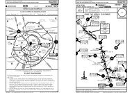
Licensed to max. Printed on 16 Feb 2008.NOTICE: PRINTED FROM AN EXPIRED REVISION. Disc 01-2008<strong>EGKK</strong>/LGWGATWICKD43 DETApt Elev202'178^OCK167^KENET 2M, 2VSAM 2M, 2VD6.8IWWR066^246^D8 MID133^BOGNA 1M, 1VHARDY 5M, 5V1320^MIDD10.5 MIDSFDSFD 4M, 4VD28 OCKNoise monitoring terminalGY260^R313^081^HORSHAM6 OCT 06IGG/IWW43IWW2.3 DME20-4KENET 3P, 3W, SAM 3P, 3W1106^JEPPESENNOISE ABATEMENTIGG3 DMEBIG 7M, 7V, CLN 8M, 8VDVR 8M, 8V, LAM 4M, 4VFor AIRPORT BRIEFINGrefer to 20-1P pages08L 08R260^SFD26R26LHORLEY080^CRAWLEY65DME2.5IGG3.5DMEIGG165^TIGER 2M, 2VWIZAD 4M, 4V262^ DETSFD080^SFD 8P, 8WGEJEPPESENJeppView 3.5.2.0LONDON, UK052^093^DET R261^LAM 5P, 5WEAST GRINSTEAD.NOISE.BIG 3P, 3WCLN 5P, 5WDVR 2P, 2WR345^DVRMAYACORNR273^R286^Licensed to max. Printed on 16 Feb 2008.NOTICE: PRINTED FROM AN EXPIRED REVISION. Disc 01-2008<strong>EGKK</strong>/LGWCRWEST PARKRWY 08L/26RC1CCY1JY2P15 OCT 07B1N1J820-8PHASE 1 - RECONSTRUCTION OF TWY AREFER ALSO TO LATEST NOTAMSPNARWY 08R/26LNBRANBJEPPESENBPIER 2YZJANASAAEMM3PIER 1M1JEPPESENJeppView 3.5.2.0LONDON, UKGATWICKYY4Y3The operation limits as specified in para 3.3.1. (refer to Airport Briefing Page 20-1P6)shall be adjusted in respect of any noise monitoring terminal to take account of thelocation and its ground elevation relative to the aerodrome elevation as follows:13456NOISE MONITORING TERMINAL/NAME/LOCATIONRuss HillOrltonsMoat HouseOaklands Park FarmBellwoodTailwind componentAmount to be disregarded1 KT0.4 dBN51 08.4 W000 15.2N51 08.1 W000 15.8N51 08.5 W000 15.7N51 09.4 W000 07.0N51 09.6 W000 07.02 KT0.8 dB3 KT1.2 dBELEVATIONABOVEAERODROME4 KT1.6 dBADJUSTMENTdb(A)54m + 5.057m + 1.94m52m + 1.93m4 KT2.0 dB0.0- 0.2If the aircraft was required to take-off with a tailwind an amount of the noise recorded atthe noise monitor should be disregarded.Runway AvailabilityTORA RWY 08RLDA RWY 08RTORA RWY 26LLDA RWY 26L9206' (2806m)8113' (2473m)9495' (2894m)8852' (2698m)RWY 08R/26L lenghts reduced to: 9695' (2955m).Eastern end of RWY 08R/26L will be closed.Runway Exit and EntryMost easterly departure point for T/O RWY 26L will be hold B1.Last exit point for acft landing RWY 08R will be twy BR.Approach and RWY lighting RWYs 08R/26LRWY 08R:CL lights OFF.No RL beyond the twy BR lead-off availableRwy end lights at the end of the shortend RWYRWY 26L:Simple approach lighting system to temporary THRPAPI (3.0^) aligned with temporary THR.Green wingbars at temporary THR.RL start at temporary THR.HIALS and supplementary lights OFF.CL lights OFF.Instrument Approach FacilitiesVisual Conditions: ILS will be switched OFF to allow work to take place up to the edge of therwy with reduced distances in operation. SRA will be available as published on 08R/26L.CAT I Conditions: Work will be restricted to an area 351'/107m from the rwy centerline. Fulldistances with ILS will be available on 08R/26L.CAT II/III Conditions: Work will be cease on site and all staff and plant will be withdrawn. Fulldistances with CAT III ILS will be available on 08R/26L.Taxiway ClosuresTwy A with rwy holding positions A1 and A3.Twy AS with rwy holding point A2.Twy AN between twy N and A.Twy AE.Twy M at its junction with Twy AN.CHANGES: Chart reindexed.| JEPPESEN SANDERSON, INC., 2004, 2006. ALL RIGHTS RESERVED.CHANGES: New temporary procedure.| JEPPESEN SANDERSON, INC., 2007. ALL RIGHTS RESERVED.
CHANGES: New temporary procedure.| JEPPESEN SANDERSON, INC., 2007. ALL RIGHTS RESERVED.Licensed to max. Printed on 16 Feb 2008.NOTICE: PRINTED FROM AN EXPIRED REVISION. Disc 01-2008<strong>EGKK</strong>/LGW5 OCT 07JEPPESEN20-8APHASE 2 - RECONSTRUCTION OF TWY AREFER ALSO TO LATEST NOTAMSJEPPESENJeppView 3.5.2.0LONDON, UKGATWICKWEST PARKJP1PNANN1J8JZANPIER 2AZ1AEMM4M3PIER 1BASAM1Y4RWY 08L/26RC1CBRB1BYCRCRWY 08R/26LY3Y1YY2Taxiway ClosuresTwy A with rwy holding positions A1 and A3.Twy AS with rwy holding point A2.Alternative Taxiway RoutesTwy Z and AN/AE will be available for Code E (MAX wingspan 213'/ 65m) acft routeing for T/O on RWY26L via twy M3 and M1.New runway holding point Z1 will be designated on twy Z West of its junction with twy M.Twy J, from its junction with twy N to its eastern end, will be restricted to acft with wingspanup to 156'/ 47.6 m.Twy Y remains available and will be used by ATC, on an opportunity basis, for routeing acftbetween RWY 08R/26L and South side of pier 1. This route is restricted to acft with wingspan upto 118'/ 36m.
Licensed to max. Printed on 16 Feb 2008.NOTICE: PRINTED FROM AN EXPIRED REVISION. Disc 01-2008<strong>EGKK</strong>/LGWApt Elev202'N51 08.9 W000 11.4TAXIWAY HOLDING POINTSD-ATISACARS:*GATWICK Delivery (Cpt)D-ATIS136.52 DCL121.9500-1200-11*Ground6 OCT 06JEPPESEN20-900-10Tower121.8 124.22JEPPESENJeppView 3.5.2.0LONDON, UKGATWICKABCD1J408LJ3J108R51-09Treesup to252'J08R080^.JAR-OPS.J2J7ApprovedOperatorsHIRL, CL& mult. RVR req125m150mP1J5H3H100-1300-13HH2CompassBase08L080^Rwy 08R/26LLVP must be in ForceRL, CL& mult. RVR req150m200mG1Blast fenceElev202'Elev196'JJG200'61mStopwayG2HGRLEGENDSynchronized flashingwhite lightHolding point forRWY 08L/26R onlyJRL & CL200m250mTAKE-OFFLVP must bein ForceRCLM (DAY only)or RL250m300m400mOperators applying U.S. Ops Specs: CL required below 300m; approved guidance system requiredbelow 150m.J6FRG287'GR1FORPARKING POSITIONSSEE 20-9AFOR HOLDING POINTSSEE INSETFRFor AIRPORT BRIEFING refer to 20-1P pagesJ8415'10,879'00-12All RwysRCLM (DAY only)or RL2565m3316mTrees up to 302' south ofand parallel to runwayMAINTENANCEAREA 2E1NIL(DAY only)500mT1TE262'00-11TAKE-OFF RUN AVAILABLERWY 08R: RWY 26L:From rwy headtwy H intint hold posn G110,364'(3159m)9462'(2884m)9140'(2786m)B1 BC1BRCR CY1Y2P1N1J8A2A1A3M3M1243'74mStopwayADDITIONAL RUNWAY INFORMATIONUSABLE LENGTHSLANDING BEYONDRWYThreshold Glide Slope TAKE-OFF08LRVR 7359' 2243mHIRL HIALS PAPI-L (angle 3.0^)26R7047' 2148m08R HIRL CL (15m) HIALS-II TDZ PAPI-R (3.0^) HST-CR & D RVR 9075' 2766m 8042' 2451m126L2HIRL CL (15m) HIALS-II TDZ PAPI-L (3.0^) HST-E & FR RVR 9288' 2831m 8255' 2516m1 RWY 08R/26L grooved.2CARGOBUILDINGARPFeetMetersCARGO AREASJ00LControlTower339'S1DRRR1D1RRA RQQQLQAQQ1JLKWEST PARKNORTHTERMINALPIER 4Elev192'500 1000 1500 2000 2500200400QBPIER 6600800LP26R260^P NNAKANASKAYZLPIER 3PIER 2294'00-10PIER 1MAINTENANCEAREA 1From rwy headint hold posn A1, A2, A3int hold posn B1JKAEAMSOUTHTERMINAL316'Y4Elev196'Y302^W276'10,679'(3255m)10,164'(3098m)9495'(2894m)26L260^51-09WIDTH148'45m151'46mCHANGES: Notes transferred to 20-1P pages.| JEPPESEN SANDERSON, INC., 1998, 2006. ALL RIGHTS RESERVED.
Licensed to max. Printed on 16 Feb 2008.NOTICE: PRINTED FROM AN EXPIRED REVISION. Disc 01-2008<strong>EGKK</strong>/LGW00-11.5 00-11 00-10.500-10LR6351-09.8LEGEND64 RLNORTHC5, 20 Parking standLR 62TERMINALHolding point for65 R51-09.7N1 Rwy 08L/26R onlyLR61Blast fence66 LL 60R68 67594651-09.6L 5847RQLL 5748 R R LRLR LR L49 R R L56RR52 515035 36 3751-09.5L L 38 L554 5453L R L R L R L R34R PIER 3LCARGOL 33553 552 551QBQR 32 31L R L R156 LLECARGORP111 112 113 101 102KA51-09.4157155 1541534143 42EWK159 158R LAREAQA QWL R LLLRR L RRL151150110 109 107 106 10519171513LRKRA 125104R 232118025MAINTENANCE152RN12 1114AREA 2KP18 16178L R160LL20RL RR L RControl136Tower135 134 133132 131 130 NA 2422281776 4 2176P1161N1 J10QL RJ8 ZR145 144 143 1421411409 5 3 1175751-09.2M174SL RL RAE173L RL RANA3R1172Q1JM3TAY4171 169ASA2 A1 M151-09.1170S1YT1B1JC1CR CBRBINS COORDINATESSTAND No. COORDINATESSTAND No. COORDINATES STAND No. COORDINATES123456791011, 12N51 09.2 W000 09.8N51 09.3 W000 09.8N51 09.2 W000 09.8N51 09.3 W000 09.9N51 09.2 W000 09.9N51 09.3 W000 09.9N51 09.2 W000 09.9N51 09.2 W000 10.0N51 09.3 W000 10.0N51 09.3 W000 09.920, 20R21L, 21, 21R222324L24, 24R25L thru 28R31L31, 31R32L, 32, 32RWESTPARKPIER 6WEST PARKRWY 08L/26RPIER 4N51 09.3 W000 10.1N51 09.4 W000 10.2N51 09.3 W000 10.2N51 09.4 W000 10.3N51 09.3 W000 10.3N51 09.3 W000 10.2N51 09.3 W000 10.3N51 09.4 W000 10.1N51 09.4 W000 10.0N51 09.4 W000 10.1RWY 08R/26L46, 4748L4848R49L, 49, 49R5051L51, 51R52L, 52, 52R53L, 53PIER 2PIER 1JEPPESEN6 OCT 06 20-9A51-09.751-09.6SOUTHTERMINALN51 09.6 W000 10.2N51 09.5 W000 10.3N51 09.6 W000 10.3N51 09.6 W000 10.2N51 09.5 W000 10.3N51 09.5 W000 10.4N51 09.5 W000 10.5N51 09.5 W000 10.4N51 09.5 W000 10.5N51 09.5 W000 10.651-09.851-09.1JEPPESENJeppView 3.5.2.0LONDON, UKGATWICKINS COORDINATESSTAND No. COORDINATES66L66, 66R67, 68101, 102104 thru 106107, 109110111L, 111, 111R112, 113125130131, 132133, 134135, 136140L thru 141142L, 142, 142R143L thru 144R145L, 145, 145R150L, 150150R, 151L151 thru 152R153, 154, 155156, 157158, 159160L, 160, 160R161169170171172173174175176177178, 180551, 552553554N51 09.7 W000 10.9N51 09.7 W000 11.0N51 09.6 W000 11.0N51 09.4 W000 10.6N51 09.3 W000 10.6N51 09.3 W000 10.7N51 09.3 W000 10.8N51 09.4 W000 10.8N51 09.4 W000 10.7N51 09.4 W000 10.9N51 09.3 W000 10.5N51 09.3 W000 10.6N51 09.3 W000 10.7N51 09.3 W000 10.8N51 09.2 W000 10.5N51 09.2 W000 10.6N51 09.2 W000 10.7N51 09.2 W000 10.8N51 09.4 W000 11.1N51 09.3 W000 11.1N51 09.3 W000 11.2N51 09.4 W000 11.1N51 09.4 W000 11.2N51 09.4 W000 11.3N51 09.3 W000 11.0N51 09.2 W000 11.0N51 09.1 W000 11.1N51 09.1 W000 11.3N51 09.1 W000 11.2N51 09.2 W000 11.3N51 09.2 W000 11.2N51 09.2 W000 11.3N51 09.2 W000 11.2N51 09.2 W000 11.3N51 09.3 W000 11.2N51 09.3 W000 11.3N51 09.5 W000 10.7N51 09.4 W000 10.8N51 09.5 W000 10.813L13, 13R14L, 14, 14R1516N51 09.4 W000 09.9N51 09.4 W000 10.0N51 09.3 W000 10.0N51 09.4 W000 10.0N51 09.3 W000 10.033L33, 33R34L thru 35R36L, 36, 36R37LN51 09.5 W000 10.2N51 09.4 W000 10.2N51 09.5 W000 10.2N51 09.6 W000 10.1N51 09.5 W000 10.053R54L, 54, 54R56L, 56, 56R57L, 5757RN51 09.5 W000 10.5N51 09.5 W000 10.6N51 09.5 W000 10.8N51 09.6 W000 10.8N51 09.5 W000 10.8171819L, 1919R20LN51 09.4 W000 10.1N51 09.3 W000 10.1N51 09.4 W000 10.1N51 09.4 W000 10.2N51 09.3 W000 10.23737R38L, 38, 38R41W thru 41E42 thru 43EN51 09.6 W000 10.0N51 09.6 W000 10.1N51 09.5 W000 10.0N51 09.4 W000 10.3N51 09.4 W000 10.458L thru 5960L thru 62R63L, 63, 63R64L, 64, 64R65L, 65, 65RN51 09.6 W000 10.8N51 09.7 W000 10.9N51 09.8 W000 10.9N51 09.8 W000 11.0N51 09.7 W000 11.0CHANGES:Stands. Notes transferred to 20-1P pages.| JEPPESEN SANDERSON, INC., 1998, 2006. ALL RIGHTS RESERVED.
CHANGES: None.| JEPPESEN SANDERSON, INC., 2000, 2006. ALL RIGHTS RESERVED.CHANGES: Visual docking guidance system.| JEPPESEN SANDERSON, INC., 2007. ALL RIGHTS RESERVED.Licensed to max. Printed on 16 Feb 2008.NOTICE: PRINTED FROM AN EXPIRED REVISION. Disc 01-2008<strong>EGKK</strong>/LGWGENERALB757767F10073715 JUN 0720-9BSTAND ENTRY GUIDANCE SYSTEMA. CENTERLINE GUIDANCE SYSTEMAGNIS-AZIMUTH GUIDANCE FOR NOSE-IN STANDSA red/green light system to guide along the stand centerline intended as a "back-up"to the stand centerline marking. It does not provide a stopping signal.It consists of a unit emitting red and/or green light signals - mounted on the front ofthe piers at pilot eye level - aligned for interpretation by the pilot in the left handseat. The signals are to be interpreted as follows:RED GREEN GREEN GREEN GREEN REDLEFT of centerline.Turn towards GREEN.JEPPESENPilot interpreted guidance systems for aircraft parking consist of two separate elements:a) Centerline Guidance -AGNIS (AZIMUTH GUIDANCE FOR NOSE-IN STANDS)b) Stopping Guidance -PAPA (PARALLAX AIRCRAFT PARKING AID),-Mirror or-Stop arrowCAUTION: The systems are aligned with the LEFT hand pilots seat only.Aircraft oncenterline.B. STOPPING GUIDANCEPAPA-PARALLAX AIRCRAFT PARKING AIDRIGHT of centerline.Turn towards GREEN.JEPPESENJeppView 3.5.2.0LONDON, UKGATWICKLicensed to max. Printed on 16 Feb 2008.NOTICE: PRINTED FROM AN EXPIRED REVISION. Disc 01-2008<strong>EGKK</strong>/LGW15 JUN 07START OF DOCKINGThe system is started by pressing one of the acft type buttons onthe operator panel. When the button has been pressed, WAITwill be displayed.CAPTUREThe floating arrows indicate that the system is activated and incapture mode, searching for an approaching acft. It shall bechecked that the correct acft type is displayed. The lead-in lineshall be followed.TRACKINGWhen the acft has been caught by the laser, the floating arrow isreplaced by the yellow centre line indicator. A flashing red arrowindicates the direction to turn. The vertical yellow arrow showsposition in relation to the centre line. This indicator gives correctposition and azimuth guidance.Flashingred arrowCLOSING RATEJEPPESEN20-9CVISUAL DOCKING GUIDANCE SYSTEMDisplay of digital countdown will start when the acft is 49'/15mfrom stop position. When the acft is less than 52'/16m from the stopposition, the closing rate is indicated by turning off one row of thecentre line symbol per 2'/0.7m covered by the acft. Thus, whenthe last row is turned off, 2'/0.7m remains to stop.ALIGNED TO CENTREThe acft is 26'/8m from the stop position. The absence of anydirection arrow indicates an acft on the centre lineSLOW DOWNIf the acft is approaching faster than the accepted speed, thesystem will show SLOW DOWN as a warning to the pilot.YellowarrowJEPPESENJeppView 3.5.2.0LONDON, UKGATWICKYellowcentre lineFloatingarrowsSLOTFLUORESCENTTUBEA320A321MD80White "STOP" lineIt consists of a reference board with a horizontal slot running across its center. This board issupported on a frame projecting from the face of the pier at pilot eye level. Behind it is aweatherproof white fluorescent tube mounted vertically and slightly to the right.Taxiing into the stand, the pilot in the left hand seat will see the fluorescent tube appear tomove along the slot towards the reference marks. Correct stopping position is reached, whenthe tubular light registers in line with the appropriate aircraft type "STOP" mark.Accuracy of this system is very much dependent upon the accuracy of the alignment on thestand centerline. It has been set up for interpretation by the pilot occupying the left hand seat.Viewed from the right hand pilot's seat the aircraft will overshoot by 3 to 10 feet/1 to 3mdepending upon acft type.AZIMUTH GUIDANCEThe acft is 13'/4m from the stop-position. The yellow arrowindicates an acft to the right of the centre line, and the redflashing arrow indicates the direction to turn.STOP POSITION REACHEDWhen the correct stop-position is reached, the display willshow STOP and red lights will be lit.DOCKING COMPLETEDWhen the acft has parked, OK will be displayed.OVERSHOOTIf the acft has overshot the stop-position, TOO FARwill be displayed.MirrorThe acft should be aligned on the stand centerline with the aid of AGNIS. The pilot in the lefthand seat should then continue to taxi forward with the reference to mirror. The acft shouldbe brought to a halt with the nosewheel on the relevant stop mark.Stop arrowA yellow painted STOP arrow is provided on the ground as a stopping guidance on some of thestands. The pilot in the left hand position must align his position with the yellow STOP arrowto find the correct parking position.STOP SHORTIf the acft is found standing still but has not reached the intendedstop position, the message STOP OK will be shown after a while.WAITIf some object is blocking the view toward the approaching acft orthe detected acft is lost during docking, before 39'/12m to STOP, thedisplay will show WAIT. The docking will continue as soon as theblocking object has disappeared or the system detects the acft again.Redlights
2211BRIEFING STRIP TMPANS OPS 4Licensed to max. Printed on 16 Feb 2008.NOTICE: PRINTED FROM AN EXPIRED REVISION. Disc 01-2008<strong>EGKK</strong>/LGWGATWICKD-ATIS136.52 126.82LOCIGG110.9965'51-10HazardBeaconCKOHazardOCKMIDHURST114.0 MID646'DM I DGATWICK Director (APP/R)FinalApch Crs080^115.3602'BeaconGATWICKG 365 Y GYMAYFIELDDM 117.9 A Y MAY131^055^627'663'270^666'020^JEPPESEN14 SEP 07 21-1 .Eff.27.Sep.GSRefer tochart 21-1A787'097^107^D27645'GATWICK Tower052^124.22 121.8ILSDA(H) Apt Elev 202'090^GYRefer tochart 21-1A130^NDB51-00287^011^107^NDBGY310^*Ground303^JEPPESENJeppView 3.5.2.0LONDON, UKILS DME Rwy 08RRWY677'196'Alt Set: hPa Rwy Elev: 7 hPa Trans level: By ATC Trans alt: 6000'ILS DME reads zero at rwy 08R displaced threshold.INITIAL APPROACHVALID FOR 90 - 240 KT TASFOR FINAL APPROACH SEE 21-1AILS DME080^ I G 110.9 G IGGD8.6IGG080^Leave MAY holding via track 260^at 3000.CHANGES: Apt & Rwy elev. ASTRA holding.D5.0 MAYD18.0 MAYD10.0 MIDAt 3000'D23.0 MAYD5.0 MID5.0At 4000'18.0277^3000D11.0 MIDAt 3000'6.0287^310^7.05.9D5.0MID3000400030002WILLOD16.9 MIDD16.9/22 MID40002LUMBATIMBALeave at4000'NOT TO SCALEDescend in holding to 4000.926'813'SFDDFSSFDD FS332^117.0639'123^D12/17 SFD854'781'700'2200'090^656'303^ASTRAD12.0 SFDWhen MID VOR u/sLeave at 4000'712'117.0Shoreham50-50| JEPPESEN SANDERSON, INC., 1999, 2007. ALL RIGHTS RESERVED.180^2000'2300'270^MSA Airport790'702'00-1000-0000-1000-2000-30BRIEFING STRIP TM0 55PANS OPS 4Licensed to max. Printed on 16 Feb 2008.NOTICE: PRINTED FROM AN EXPIRED REVISION. Disc 01-2008<strong>EGKK</strong>/LGWGATWICK646'D8.6IGGJEPPESEN14 SEP 0721-1AGATWICK Director (APP/R)965'GATWICKG 365 YGYD4.0IGGHazardBeaconD2.0IGGD0.5IGGHazardBeaconD1.0IGG602'JEPPESENJeppView 3.5.2.0LONDON, UKCAT I/II ILS DME Rwy 08RGATWICK Tower136.52 126.82124.22 121.8LOC FinalGS CAT II ILS ILSIGG Apch Crs D4.0 IGG RA 96'Apt Elev 202'DA(H)DA(H)110.9 080^ 1526'(1330') 296'(100') 396'(200') RWY196'MISSED APCH: Climb STRAIGHT AHEAD (MAX 250 KT) to 3000',then as directed. In the event of complete radio failure see 28-2.Alt Set: hPa Rwy Elev: 7 hPa Trans level: By ATC Trans alt: 6000'1. CAT II ILS: Special Aircrew & Acft Certification Required.2. ILS DME reads zero at rwy 08R displaced threshold.51-1051-05LOC(GS out)D-ATISD8.6 IGG3000'LOCLctrD4.2 IGGGS1596'D4.0IGGGS1526'LOCD2.0IGGD1.0 IGGGnd speed-Kts 70 90 100 120 140 160ILS GS 3.00^ orLOC Descent Gradient 5.2%377 485 539 647 755 862MAP at D0.5 IGGSTRAIGHT-IN LANDING RWY 08R.JAR-OPS.683'080^.Eff.27.Sep.I G GILS DME080^ 110.9 IGGCAT II ILSABCDRA 96'DA(H) 296'(100')RVR 300m 1D0.5IGG627'*Ground00-30 00-2000-1000-00IGG DMEALTITUDE080^8.02810'1600'4.4 0.2CHANGES: Apt & Rwy elev. Minimums.D4.2 IGG20007.02490'2.0260^6.02170'760'FOR INITIAL APPROACH SEE 21-1GS 566'1.0 0.5080^0.5TCH displthresh 51'090^ 270^666'250 KT 3000'MAX| JEPPESEN SANDERSON, INC., 1999, 2007. ALL RIGHTS RESERVED.180^2200' 2300'2000'MSA AirportRWY 08R.JAR-OPS.STRAIGHT-IN LANDING RWY 08RCIRCLE-TO-LANDILSLOC (GS out)DA(H) 396'(200')MDA(H) 720'(524')FULL ALS out ALS outMaxKts MDA(H) VISARVR 1000m100 810' (608') 1500mRVR 1500mB135 810' (608') 1600mRVR 550mRVR 1000mRVR 1200mC180 1110' (908') 2400mRVR 2000mDRVR 1600m205 1110' (908') 3600m1Operators applying U.S. Ops Specs: Autoland or HGS required below RVR 350m.5.01850'4.01530'HIALS-IIPAPI3.01210'2.0890'196'
BRIEFING STRIP TMPANS OPS 4Licensed to max. Printed on 16 Feb 2008.NOTICE: PRINTED FROM AN EXPIRED REVISION. Disc 01-2008<strong>EGKK</strong>/LGWGATWICK51-1051-0050-50D-ATIS136.52 126.82LOCIWW110.9HazardBeaconGATWICK338 G GE EGATWICK Director (APP/R)FinalApch Crs260^OCK115.3Leave MAY holding viaD1.5 MAY at 3000, turn LEFTto intercept R-005 MAY VOR.At D3.0 MAY descend to 2000.JEPPESEN14 SEP 07 21-2 .Eff.27.Sep.GSRefer tochart 21-2ACKO131^GATWICK Tower090^00-10 00-00124.22 121.8ILSDA(H) Apt Elev 202'Refer tochart 21-2AAlt Set: hPa Rwy Elev: 7 hPa Trans level: By ATCILS DME reads zero at rwy 26L displaced threshold.734'1854'MIDHURSTD114.0 MID2WILLOLeave at4000'107^1014'677'ILS DME260^ I 110.9 W WIWW602'D22.0MID813'790'287^CHANGES: Apt & Rwy elev. ASTRA holding.774'627'D5.0MAY656'1035'260^D5.5IWW639'666'4000123^276^270^D271D1.5MAY044^823'2ASTRAD12.0 SFDLeave at4000'005^120008.5Arrival from ASTRAif MID VOR u/sMAYFIELDDM 117.9 A YMAYD12/17 SFD303^*GroundRWY303^SFD D S117.0FJEPPESENJeppView 3.5.2.0LONDON, UKILS DME Rwy 26L196'Trans alt: 6000'D8.5 MAYAt 2000'310^645'MAYFIELDDM 117.9 A YMAY40002 Descend in holding to 4000.130^310^926'00-10 00-20| JEPPESEN SANDERSON, INC., 1999, 2007. ALL RIGHTS RESERVED.7.02TIMBALUMBA4000 042^4000Continue as above005^2200'090^180^2000'2300'INITIAL APPROACHVALID FOR 90 - 240 KT TASFOR FINAL APPROACH SEE 21-2A787'At 4000'At 4000'1007'663'MSAARP270^630'BRIEFING STRIP TM0 55PANS OPS 4Licensed to max. Printed on 16 Feb 2008.NOTICE: PRINTED FROM AN EXPIRED REVISION. Disc 01-2008<strong>EGKK</strong>/LGWGATWICKJEPPESEN14 SEP 07.Eff.27.Sep.21-2AGATWICK Director (APP/R)D0.5IWWD4.0 IWWD0.5IWWD1.0IWWD1.0 IWWD5.5IWWJEPPESENJeppView 3.5.2.0LONDON, UKCAT I/II ILS DME Rwy 26LGATWICK Tower*Ground136.52 126.82124.22 121.8LOC FinalGS CAT II ILS ILSApt Elev 202'IWW Apch Crs Lctr RA 102' DA(H)DA(H)110.9 260^ 1526'(1330') 296'(100') 396'(200') RWY196'MISSED APCH: Climb STRAIGHT AHEAD (MAX 250 KT) to 3000',then as directed. In the event of complete radio failure see 28-2.Alt Set: hPa Rwy Elev: 7 hPaTrans level: By ATC1. CAT II ILS: Special Aircrew & Acft Certification Required.2. ILS DME reads zero at rwy 26L displaced threshold.51-15742'51-10965'LOC(GS out)Gnd speed-Kts 70 90 100 120 140 160ILS GS 3.00^ orLOC Descent Gradient 5.2%377 485 539 647 755 862MAP at D0.5 IWWSTRAIGHT-IN LANDING RWY 26L.JAR-OPS.D-ATISRWY 26L196'771'HazardBeacon1014'HazardBeacon602'00-20 00-1000-00 00-10IWW DMEALTITUDETCH displthresh 51'260^0.5CAT II ILSABCDRA 102'DA(H) 296'(100')RVR 300m 1D5.5IWW250 KT 3000'MAX.JAR-OPS.STRAIGHT-IN LANDING RWY 26LCIRCLE-TO-LANDILSLOC (GS out)DA(H) 396'(200')MDA(H) 700'(504')FULL ALS out ALS outMaxKts MDA(H) VISARVR 1000m100 810' (608') 1500mRVR 1500mB135 810' (608') 1600mRVR 550mRVR 1000mRVR 1200mC180 1110' (908') 2400mRVR 2000mDRVR 1600m205 1110' (908') 3600m1Operators applying U.S. Ops Specs: Autoland or HGS required below RVR 350m.CHANGES: Apt & Rwy elev. Minimums.2.0890'GATWICK338 G GE E0.5GS 566'791'080^2000Trans alt: 6000'I W W820'ILS DME260^ 110.9 IWW260^702'FOR INITIAL APPROACH SEE 21-23.01210'3.0LctrD4.0 IWWGS 1526'4.01530'LOC1530'1.5HIALS-IIPAPI260^090^ 270^2000'| JEPPESEN SANDERSON, INC., 1999, 2007. ALL RIGHTS RESERVED.180^2200' 2300'2000'MSA ARP5.01850'
BRIEFING STRIP TMLicensed to max. Printed on 16 Feb 2008.NOTICE: PRINTED FROM AN EXPIRED REVISION. Disc 01-2008<strong>EGKK</strong>/LGWGATWICKRNAV136.52 126.82FinalApch CrsMISSED APCH: Climb STRAIGHT AHEAD to 3000' to KKMA1, then asdirected. In the event of complete radio failure see 28-2.080^ 080^2810'080^MIDMID114.0GATWICK Director (APP/R)Minimum AltK~8RF3000'(2804')HazardBeacon106^HazardBeaconJEPPESEN22-1GATWICK TowerMDA(H)700'(504')2490' 2170' 1850' 1530'JEPPESENJeppView 3.5.2.0LONDON, UKRNAV GNSS Rwy 08R*Ground124.22 121.8Apt Elev 202'RWY196'Alt Set: hPa Rwy Elev: 7 hPa Trans level: By ATC Trans alt: 6000'1. When required, acft will be radar vectored from WILLO to final approach course.2. In the event of radio communication failure follow conventional arrival proceduresto establish on final approach course. 3. GNSS or RNP-0.3 required. 4. Pilots shouldrequest RNAV approach on first contact with Director.51-10(IF)ABIBI51-00DIST to RW~8RALTITUDED-ATISK~8RF965'7 DEC 07RW~8RWILLOD16.9 MIDD11.8/R-262 MAY107^602'287^627'D5.0 MAY090^00-20 00-1000-00666'1210'180^2200' 2300'090^ 270^KKMA12000'MSAARP270^MAYFIELDDM 117.9 A YMAY8.0 7.0 6.0 5.0 4.0 3.02.0890'BRIEFING STRIP TMLicensed to max. Printed on 16 Feb 2008.NOTICE: PRINTED FROM AN EXPIRED REVISION. Disc 01-2008<strong>EGKK</strong>/LGWGATWICKRNAV136.52 126.82FinalApch Crs260^GATWICK Director (APP/R)MISSED APCH: Climb STRAIGHT AHEAD to 3000' to KKMA2, then asdirected. In the event of complete radio failure see 28-2.1210'Minimum AltGATSU3000'(2804')106^1530'GATWICK TowerMDA(H)1850'JEPPESENJeppView 3.5.2.0LONDON, UKRNAV GNSS Rwy 26L124.22 121.8Apt Elev 202'RWY2170'196'Alt Set: hPa Rwy Elev: 7 hPa Trans level: By ATC Trans alt: 6000'1. Acft will normally be radar vectored from the STAR holding/initial apch fixes.2. In the event of radio communication failure follow conventional arrival proceduresto establish on final approach course. 3. GNSS or RNP-0.3 required.4. Pilots should request RNAV approach on first contact with Director.51-1051-00840'837'KKMA2890'260^JEPPESEN22-2HazardBeaconHazardBeaconRW26LD5.0 MAY090^GATSU270^2490'*Ground(IF)OLEVI00-40 00-3000-20677' 00-1000-00 00-10DIST to RW26LALTITUDED-ATIS646'683'MIDHURSTDM 114.0 I DMID2.0742'965'3.07 DEC 07771'4.0590'(394')1014'WILLO602'D16.9 MIDD11.8/R-262 MAY107^5.0287^774'627'6.01035'823'260^666'7.0820'180^2200' 2300'090^ 270^2000'MSAARP787'702'MAYFIELDDM 117.9 A YMAY8.02810'645'3000'ABIBI080^K~8RF[3.00^]RW~8RRW26L[3.00^]GATSU260^OLEVI3000'PANS OPS 4Gnd speed-Kts 70 90 100 120 140 160Descent angle [3.00^] 372 478 531 637 743 849MAP at RW~8R.JAR-OPS.ABCD2.0RVR 1000mRVR 1200mRVR 1600mCHANGES: New procedure.08RLNAV-VNAV RNP 0.3MDA(H) 700'(504')ALS outSTRAIGHT-IN LANDING RWYRVR 1500mRVR 2000mMaxKts100135180205HIALS-IIPAPI[TCH displthresh 53']8.6 RWY 08R 196'3000'KKMA1CIRCLE-TO-LANDMDA(H)810'(608')810'(608')1110' (908')1110' (908')VIS1500m1600m2400m3600m| JEPPESEN SANDERSON, INC., 2007. ALL RIGHTS RESERVED.PANS OPS 4[TCH displthresh 53']Gnd speed-Kts 70 90 100 120 140 160Descent angle [3.00^] 372 478 531 637 743 849MAP at RW26L.JAR-OPS.ABCDRWY 26L196'RVR900mRVR 1000mRVR 1400mCHANGES: New procedure.26LCIRCLE-TO-LANDLNAV-VNAV RNP 0.3MDA(H) 590'(394')MaxALS out Kts MDA(H) VIS100 810'(608') 1500mRVR 1500m135 810'(608') 1600mSTRAIGHT-IN LANDING RWY8.6RVR 1800mRVR 2000mPAPI180205HIALS-II2.03000'KKMA21110' (908')1110' (908')2400m3600m| JEPPESEN SANDERSON, INC., 2007. ALL RIGHTS RESERVED.
2211BRIEFING STRIP TMPANS OPS 4Licensed to max. Printed on 16 Feb 2008.NOTICE: PRINTED FROM AN EXPIRED REVISION. Disc 01-2008<strong>EGKK</strong>/LGWGATWICKD-ATISGATWICK Director (APP/R)CKOOCK115.3131^055^020^JEPPESEN14 SEP 07 26-1 .Eff.27.Sep.097^107^D27GATWICK Tower052^GYNDB011^NDBGYJEPPESENJeppView 3.5.2.0LONDON, UKNDB DME Rwy 08R*Ground136.52 126.82124.22 121.8LctrFinal Minimum Alt MDA(H) Apt Elev 202'GYApch CrsRefer toRefer to365 080^ chart 26-1A chart 26-1A RWY 196'Alt Set: hPa Rwy Elev: 7 hPa Trans level: By ATC Trans alt: 6000'ILS DME reads zero at rwy 08R displaced threshold.INITIAL APPROACHVALID FOR 90 - 240 KT TASFOR FINAL APPROACH SEE 26-1AGATWICKG 365 Y GY965'51-10080^HazardBeaconD8.6IGGMIDHURST114.0 MID646'DM I DLeave MAY holding via track 260^at 3000.ILS DMEI 110.9 G IGG G602'627'663'MAYFIELDDM 117.9 A MAY Y270^666'CHANGES: Apt & Rwy elev. ASTRA holding.787'D5.0 MAYD18.0 MAYD10.0 MIDAt 3000'D23.0 MAYD5.0 MID4000'5.0At18.0277^645'30006.0287^090^D11.0 MIDAt 3000'130^310^7.05.9D5.0MID51-004000287^300030002WILLOD16.9 MID107^D16.9/22 MID310^40002LUMBATIMBALeave at4000'NOT TO SCALEDescend in holding to 4000.677'926'813'303^854'700'SFDDFSSFDD FS332^117.0781'639'123^D12/17 SFDASTRA2200'090^656'303^D12.0 SFDWhen MID VOR u/sLeave at 4000'712'117.0Shoreham50-50| JEPPESEN SANDERSON, INC., 1999, 2007. ALL RIGHTS RESERVED.180^2000'2300'790'270^MSA Airport702'00-1000-0000-1000-2000-30BRIEFING STRIP TMPANS OPS 4Licensed to max. Printed on 16 Feb 2008.NOTICE: PRINTED FROM AN EXPIRED REVISION. Disc 01-2008<strong>EGKK</strong>/LGWGATWICKMISSED APCH: Climb STRAIGHT AHEAD (MAX 250 KT) to 3000',then as directed. In the event of complete radio failure see 28-2.(IAF)GATWICKG 365 YGYJEPPESEN14 SEP 07 26-1A .Eff.27.Sep.GATWICK Director (APP/R)136.52 126.82LctrFinal Minimum AltGYApch CrsLctr365646'D8.6 IGG080^742'1600'(1404')D8.6IGG D2.0With DME:W/o DME:Lctr965'IGGD2.0IGGGATWICK TowerD0.5IGGGnd speed-Kts 70 90 100 120 140 160Descent Gradient5.2% 369 474 527 632 737 843MAP at D0.5 IGG orLctr to MAP3.7 3:10 2:28 2:13 1:51 1:35 1:23JEPPESENJeppView 3.5.2.0LONDON, UKNDB DME Rwy 08R*Ground124.22 121.8MDA(H)Apt Elev 202'720'(524')HazardBeaconHazardBeaconRWY602'D0.5IGG196'Alt Set: hPa Rwy Elev: 7 hPa Trans level: By ATC Trans alt: 6000'1. ILS DME reads zero at rwy 08R displaced threshold. 2. Acft unable to receive DMEadvise ATC.51-1051-00ABCDIGG DMEALTITUDE3000'.JAR-OPS.D-ATIS683'D4.2 IGG080^627'Acft will normally be radar vectored to extended final approach track,to be at 3000' established by 10NM before displ thresh.During daylight hours only , acft may be radar vectored to extendedfinal approach track to be at 2000' established by 7NM before displthresh. Descent point for 5.2% Desc Grad is D5.5 IGG.Radar vectored acft will be provided with radar range when on extendedfinal apch track and approaching the descent point for 5.2% Desc Grad at9NM from 3000' or 6NM from 2000' before displ thresh.00-30 00-2000-1000-008.02810'080^1600'4.4with DMED4.2 IGGCHANGES: Apt & Rwy elev. Minimums.7.02490'080^20002.2260^6.02170'STRAIGHT-IN LANDING RWY080^760'08R(CONDITIONAL)FOR INITIAL APPROACH SEE 26-1080^090^ 270^666'250 KT 3000'MAX| JEPPESEN SANDERSON, INC., 1999, 2007. ALL RIGHTS RESERVED.180^2200' 2300'2000'MSA AirportRWY 08RCIRCLE-TO-LANDMDA(H) 720'(524')MDA(H) 760'(564')ALS out ALS outMaxKts MDA(H) VISRVR 1000mRVR 1000m100 810' (608') 1500mRVR 1500mRVR 1500m135 810' (608') 1600mRVR 1200mRVR 1200m180 1110' (908') 2400mRVR 2000mRVR 2000mRVR 1600mRVR 1600m205 1110' (908') 3600m5.01850'w/o DME1.54.01530'ILS DMEI 110.9 G IGGG0.5HIALS-IIPAPI3.01210'2.0890'196'
BRIEFING STRIP TMPANS OPS 4Licensed to max. Printed on 16 Feb 2008.NOTICE: PRINTED FROM AN EXPIRED REVISION. Disc 01-2008<strong>EGKK</strong>GATWICK1ATIS136.52RADARRVR 1000mRVR 1200mRVR 1600mGATWICK Director (APP/R)28-1JEPPESENJeppView 3.5.2.0126.82 125.87 124.22 121.8Final Minimum Alt MDA(H) Apt Elev 196'Apch CrsSeeRefer toBy ATC table below Minimums RWY - See below2200' 2300'RVR 1500mRVR 2000mRVR 900mRVR 1000mRVR 1400mGATWICK RadarRVR 1500mRVR 2000mGATWICK TowerMISSED APCH: Climb STRAIGHT AHEAD (MAX IAS 250 KT) to 3000',then as directed. In the event of complete radio failure see 28-2.Alt Set: hPa Rwy Elev: 7 hPa Trans level: By ATC Trans alt: 6000' (5805')51-1551-1051-05ABCD00-30080^00-2019 JUL 02After SRA 08L/26R apch: MDA(H) 850'(654').CHANGES: Bearings.G 365 GATWICKYGYILS DMEI G G080^ 110.9 IGGMinimum Alt/NMSRA 08L & 26L/RSRA 08RMDA(H)720'2000(525')ALS outJEPPESEN1. QFE altimeter setting normally used during final approach. 2. ILS DME reads zero atdisplaced threshold rwys 08L, 08R and 26L and at 0.5 NM before displaced thresholdrwy 26R.ACFT CATOCA(H) RWYBASED ON ELEV.RVR 1800mG EGATWICK338 GE260^ 080^STRAIGHT-IN LANDING00-10Gnd speed-Kts 70 90 100 120 140 160Descent Gradient 4.9% 347 447 496 595 695 794SRA 08L/26R: MAP 2 NM from touchdownSRA 08R/26L: MAP 1 NM from touchdown orTMN 2 to MAP1.0 0:51 0:40 0:36 0:30 0:26 0:23.JAR-OPS.SRA 08RALL08R1900' (1705') 1300' (1105')195'715'(520')26L195'610'(415')SRA 26LALL08L/26R195'845'(650')MDA(H) 610'(415')ALS out850' (655')MDA(H) 850'(655')ALS outRVR 1800mRVR 2000mSRA 08L/26RRVR 1500mRVR 2000mLighting -Refer toAirportChart100135180205LONDON, UKSRA All RwysILS DMEI W W00-00*Ground260^ 110.9 IWW2000MaxKts090^ 270^260^250 KT 3000'MAXMDA(H)1800'(604')1500m1800'(604') 1600m1100' (904') 2400m1100' (904') 3600m| JEPPESEN SANDERSON, INC., 1999, 2002. ALL RIGHTS RESERVED.180^2000'MSAAirportRADAR FIX 5.04.0 3.0 2.0ALTITUDE (HAT) 1750'(1555') 1450'(1255') 1150'(955') 850'(655')SRA TMN 2.0 NM742'965'5.5 FAFALL771'HazardBeaconHazardBeacon1014'4.0 2.0602'774'627'876'666'823'820'CIRCLE-TO-LANDVISLicensed to max. Printed on 16 Feb 2008.NOTICE: PRINTED FROM AN EXPIRED REVISION. Disc 01-2008<strong>EGKK</strong>MSA2200'51-20EG(D)-133EG(D)-133AEG(D)-132840'51-1051-00837'00-40Fairoaks080^MIDHURSTVOR DMEMSA2000'00-30RADARVECTORING AREAOCKHAMVOR DMEILS DME 08R00-2019 JUL 02EPSOMNDBGY NDB080^ 110.9 IGGWithin the Radar Vectoring Area 2000' is theminimum initial altitude to be allocatedthe radar controller. Descent below 2000'PROCE-DURERwys08L/RRwys2000'26L/RCHANGES: Bearings.D10.0 IWW646'2000'742'965'by28-2EG(R)-15100-10Biggin HillGE NDBLOSS OF COMMUNICATION PROCEDUREINITIAL APPROACHContinue visually or bymeans of an appropriatefinal approach aid.If not possible proceed toMAYFIELD VOR DME at3000' or at last assignedlevel if higher.JEPPESENRADAR VECTORING AREA771'HazardBeaconHazardBeacon1014'677'602'774'627'Continue visually or bymeans of an appropriatefinal approach aid.If not possible followthe Missed ApproachProcedure to MAYFIELDVOR DME.D10.0 IGG2000'ILS DME 26LJEPPESENJeppView 3.5.2.000-00 00-10GATWICK260^260^ 110.9 IWWMAYFIELDVOR DMELONDON, UKBIGGINVOR DME2000'MSA2000'MISSED APPROACHMSA2300'will be given within the intermediate and finalapproach area when on 40^ leg or final approach.INTERMEDIATE AND FINALAPPROACH876'666'823'820'787'702'663'In the event of completeradio failure, climbSTRAIGHT AHEAD to D10.0IGG (R-356 MAY VOR foracft unable to receive IGGDME), then proceed toto MAYFIELD VOR DME notabove 3000'.In the event of completeradio failure, climbSTRAIGHT AHEAD to D10.0IWW (R-288 MAY VOR foracft unable to receive IWWDME), then proceed toto MAYFIELD VOR DME notabove 3000'.645'1007'| JEPPESEN SANDERSON, INC., 1999, 2002. ALL RIGHTS RESERVED.