TH-D72A/E - N3UJJ
TH-D72A/E - N3UJJ
TH-D72A/E - N3UJJ

You also want an ePaper? Increase the reach of your titles
YUMPU automatically turns print PDFs into web optimized ePapers that Google loves.
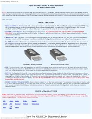
2 HOW YOU ENJOY APRS WI<strong>TH</strong> <strong>TH</strong>-<strong>D72A</strong>/E (WRITTEN BY BOB BRUNINGA, WB4APR)Digipeater Path InformationAnother new information feature of <strong>TH</strong>-<strong>D72A</strong>/E isthe digipeater path display shown here. This displayshows the First and Last digipeaters used. MostAPRS areas encourage the use of only 2 hops orless. This means, in most cases, the full path isvisible. In this image the WB3V-6 packet was Firstheard by the N3KTX-1 digipeater and then it wasdelivered to my radio by the Last hop on the KV3B-2digipeater. This path knowledge is very valuable tothe operator in understanding his local areanetwork. This display is just one of the 9 pages ofadditional information available on each stationheard by <strong>TH</strong>-<strong>D72A</strong>/E and captured in the station list.APRS Radio Map CapabilitiesAll of the Kenwood APRS radios can display all stations in the Station list on any attached GPS mapdisplay if the GPS supports standard NMEA waypoints. These stations are shown with the GPS'snative generic waypoint symbol except for those that are compatible with the special Kenwoodinterface such as the AvMap G5/G6 which has the full APRS symbol set (shown below) and theGarmin nuvi 350 which requires the corresponding conversion cable supplied by Argent Data Systemand has about 50 different symbols. The nuvi 350 needs a GTRANS Kenwood to Garmin translatorcable available from http://argentdata.com. The AvMap is designed for 100% compatibility with thenearly 200 APRS symbols. The data cable manufactured by Argent translates the special Kenwooddata format into the 50 or so Garmin symbol set where possible.(Image of AvMap by Don Arnold, W6GPS and nuvi 350 by Mike Wren, N2QDK)Other APRS Information ResourcesThe information available to the mobile operator is unlimited. APRS is not an end in itself, but theinformation is not available if no one is transmitting it. The potential is still wide open for additionalcontent. This is not spam, but real immediate information of value to the mobile or traveler. Thereare many examples of data sources that have been implemented in some local areas.Traffic speeds at select choke points: refer to: http://aprs.org/traffic.htmlMF Mobile Satellites in view: refer to: http://aprs.org/satinfo.htmlUI-InfoKiosk local info database: refer to http://www.apritch.myby.co.uk/infokiosk.htm.12 CONTENTS <strong>TH</strong>-<strong>D72A</strong>/EFrom The <strong>N3UJJ</strong>.COM Document Library