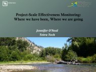
Presentation Title - Washington State Recreation and Conservation ...
Presentation Title - Washington State Recreation and Conservation ...
Presentation Title - Washington State Recreation and Conservation ...

You also want an ePaper? Increase the reach of your titles
YUMPU automatically turns print PDFs into web optimized ePapers that Google loves.
Conceptual Model for Assessing <strong>Recreation</strong>al SafetyRelated to Habitat Improvement ProjectsR. Leif Embertson, MS, PESalmon Recovery Funding Board – Salmon Habitat ConferenceApril 27, 2011WE FIND A BETTER WAY
Approach• <strong>Recreation</strong>al user safety is a function of;— Reach characteristics— Structure characteristicsWE FIND A BETTER WAY
Reach Factors• Define therecreational use— Frequency of useWE FIND A BETTER WAY
Reach Factors• Define therecreational use— Frequency of use— Access to projectreachWE FIND A BETTER WAY
Reach Factors• Define therecreational use— Frequency of use— Access to projectreach— <strong>Recreation</strong>alflow rangeWE FIND A BETTER WAY
Reach Factors• Define the recreational use (continued)— Ability of usersWE FIND A BETTER WAY
Reach Factors• Define the recreational use (continued)— Ability of users1WE FIND A BETTER WAY
Reach Factors• Define the recreational use (continued)— Ability of users1 2WE FIND A BETTER WAY
Reach Factors• Define the recreational use (continued)— Ability of users1 2 3WE FIND A BETTER WAY
Reach Factors• Define the geomorphic indices— Channel type1WE FIND A BETTER WAY
Reach Factors• Define the geomorphic indices— Channel type1 2WE FIND A BETTER WAY
Reach Factors• Define the geomorphic indices— Channel type1 2 3WE FIND A BETTER WAY
Reach Factors• Define the geomorphic indices (continued)— Channel gradientWE FIND A BETTER WAY
Reach Factors• Define the geomorphic indices (continued)— Channel gradient— Channel stabilityWE FIND A BETTER WAY
Reach Factors• Define the geomorphic indices (continued)— Channel gradient— Channel stability1WE FIND A BETTER WAY
Reach Factors• Define the geomorphic indices (continued)— Channel gradient— Channel stability1 2WE FIND A BETTER WAY
Reach Factors• Define the geomorphic indices (continued)— Frequency of natural large wood*• Low (25th <strong>and</strong> 75th %)*.Fox, M., S. Bolton, 2007. A Regional <strong>and</strong> GeomorphicReference for Quantities <strong>and</strong> Volumes of InstreamWood in Unmanaged Forested Basins of <strong>Washington</strong><strong>State</strong>. North American Journal of FisheriesManagement 24:342-359, March 1, 2007.WE FIND A BETTER WAY
Structure Factors• What is location of the structure?— Outside of a channel bend?— Within wetted area during recreational flow?SOUTH FORK NOOKSACKSKOOKUM REACHSOUTH FORK NOOKSACKFOBES REACHWE FIND A BETTER WAY
Structure Factors• What are thestructurecharacteristics?— Strainerpotential— Structure type**.Abbe, T.B. <strong>and</strong> D.R.Montgomery. 2003.Patterns <strong>and</strong> Processes of WoodAccumulation in the Queets River Basin,<strong>Washington</strong>. Geomorphology 51:81-107.WE FIND A BETTER WAY
Structure Factors• What is the avoidancepotential?— Sight Distance— Can the structure beportaged?— Wading safety factor(WSF)*WSF = Velocity*Depth*.Abt, S.R., Wittler, R.J., Taylor, A., <strong>and</strong> D.J. Love,1989. Human stability in a high flood hazard zone.American Water Resources Association, WaterResources Bulletin, 25(4) 881-889, August 1989.WE FIND A BETTER WAY
Assessment ModelWE FIND A BETTER WAY
Project ExampleCavanaugh Isl<strong>and</strong>Restoration South ForkNooksack RiverObjectives1. Increase duration <strong>and</strong>amount of flow withinside channel2. Increase pool habitat3. Promote forested isl<strong>and</strong>stabilityWE FIND A BETTER WAY
Project Example (continued)WE FIND A BETTER WAY
Project Example (continued)ELJ 4 – APEXJAMWE FIND A BETTER WAY
Project Example (continued)ELJ 4 – APEXJAMWE FIND A BETTER WAY
Project Example (continued)ELJ 4 – APEXJAMWE FIND A BETTER WAY
Project Example (continued)ELJ 4 – APEXJAMWE FIND A BETTER WAY
Project Example (continued)ELJ 4 – APEXJAMWE FIND A BETTER WAY
Project Example (continued)ELJ 4 – APEXJAMWE FIND A BETTER WAY
Project Example (continued)ELJ 4 – APEXJAMWE FIND A BETTER WAY
Project Example (continued)ELJ 4 – APEXJAMWE FIND A BETTER WAY
Project Example (continued)ELJ 4 – APEXJAMWE FIND A BETTER WAY
Project Example (continued)ELJ 4 – APEXJAMWE FIND A BETTER WAY
Project Example (continued)ELJ 4 – APEXJAMWE FIND A BETTER WAY
Project Example (continued)ELJ 4 – APEXJAMWE FIND A BETTER WAY
Project Example (continued)ELJ 4 – APEXJAMRESULTMODERATE SAFETYRATINGWE FIND A BETTER WAY
So Now What…• Risk can be mitigated through— Public education/outreach— Public notification— Signage— Monitoring— Adaptive managementWE FIND A BETTER WAY
Questions / DiscussionWE FIND A BETTER WAY
Reach Factors• Define the recreational use (continued)— Ability of users1 2 3WE FIND A BETTER WAY
Reach Factors• Define the geomorphic indices— Channel type1 2 3WE FIND A BETTER WAY
Reach Factors• Define the geomorphic indices (continued)— Channel gradient— Channel stability1 2WE FIND A BETTER WAY
Structure Factors• What is location of the structure?— Outside of a channel bend?— Within wetted area during recreational flow?SOUTH FORK NOOKSACKSKOOKUM REACHSOUTH FORK NOOKSACKFOBES REACHWE FIND A BETTER WAY
Project Example (continued)ELJ 4 – APEXJAMRESULTMODERATE SAFETYRATINGWE FIND A BETTER WAY