You also want an ePaper? Increase the reach of your titles
YUMPU automatically turns print PDFs into web optimized ePapers that Google loves.
High SierraClimbingtitleSECOND EDITIONpageChris McNamaraMcKenzie Long
High SierraClimbingCalifornia’s Best HighCountry ClimbsChris McNamaraMcKenzie Long
Published bySuper<strong>Topo</strong>2 Bradford WayMill Valley, CA 94941www.supertopo.comCopyright 2013 by Super<strong>Topo</strong> LLCNo part of this book may be reproduced in any form, or by any electronic,mechanical or other means, without permission in writing from the publisher.<strong>Topo</strong>s and text by Chris McNamara, McKenzie Long, Todd Vogel, SP Parker, and Greg BarnesHistory by Andy Selters and Steve RoperDesigner: McKenzie LongPublisher: Chris McNamaraFront cover: Trish McGuire climbing the amazing final pitch on the Third Pillar of Dana (5.10b).Touted as “the best pitch in the universe.” Photo: Ken EtzelBack cover: While on the Thunderbolt to Sill Traverse in the Palisades, Brian Russell makes hisway to the U Notch, with a building storm and the fifth and final fourteener, Mt. Sill (14,153 ft),on the horizon. Photo: Ken EtzelChris McNamara and McKenzie LongHigh Sierra Climbing: California’s Best High Country ClimbsISBN: 978-0-9833225-3-53HIGH SIERRA CLIMBING: SUPERTOPO
ContentsAcknowledgements 5Introduction 6Free Climbing Ratings 22Cam Sizes by Brand 23Lone Pine Peak 26North Ridge, 5.5 28Mt. Whitney 32East Face, 5.7 40East Buttress, 5.7 46Mountaineer’s Route 49Keeler Needle 50Harding Route 5.10c 51Mount Russell 55Fishhook Arête, 5.9 58Mithral Dihedral, 5.10a 62East Ridge, 3rd class 65Charlotte Dome 66South Face 5.8 70Temple Crag 74Venusian Blind 5.7 78Moon Goddess Arête 5.8 81Sun Ribbon Arête 5.10a 84Dark Star 5.10c 88Mount Sill 92Swiss Arête 5.7 93North Palisade 96U Notch AI2, 4th Class 97Mount Goode 100North Buttress 5.9 103Cardinal Pinnacle 105West Face 5.10a 106Mount Emerson 110Southeast Face 5.4 112Mount Humphreys 114East Arête 5.5 117Merriam Peak 122North Buttress 5.10b 124Bear Creek Spire 128North Arête 5.8 132Northeast Ridge 5.5 135Petite Griffon 138Southeast Face 5.7 139Laurel Mountain 142Northeast Gully 5.2 146Crystal Crag 148North Arête 5.7 150Clyde Minaret 152Southeast Face 5.8 154Mount Ritter 159Southeast Glacier, 3rd Class 160Third Pillar of Dana 162Regular Route 5.10b 164Cathedral Peak 166Southeast Buttress 5.6 168Eichorn’s Pinnacle 172West Pillar 5.9 173Matthes Crest 177Traverse, South to North, 5.7 178Tenaya Peak 182Northwest Buttress 5.5 184Mount Conness, W Ridge & SW Face 186West Ridge 5.6 189Southwest Face 5.10c 192Mount Conness, North Ridge 195North Ridge 5.6 198North Peak 200Northeast Couloir AI2, 4th class 202Matterhorn Peak 204North Arête 5.7 206Incredible Hulk 210Sunspot Dihedral 5.11b 215Positive Vibrations 5.11a 218Red Dihedral 5.10b 222Falling Dihedral 5.10a 226Appendix 228Budding Alpine Climber Ticklist 228Sierra Snow Climbs 228Sierra Hardman/woman Ticklist 229Impressive Link-ups 229Climbs by Rating 230Climbs by Name 2314FOR CURRENT ROUTE INFORMATION, VISIT WWW.SUPERTOPO.COM
Warning!Climbing is an inherently dangerous sport in which severe injuries or death may occur.Relying on the information in this book may increase the danger.When climbing you can only rely on your skill, training, experience, and conditioning. If youhave any doubts as to your ability to safely climb any route in this guide, do not try it.This book is neither a professional climbing instructor nor a substitute for one. It is not aninstructional book. Do not use it as one. It contains information that is nothing more than acompilation of opinions about climbing in the High Sierra. These opinions are neither facts norpromises. Treat the information as opinions and nothing more. Do not substitute these opinionsfor your own common sense and experience.Assumption of RiskThere may be errors in this book resulting from the mistakes of the authors and/or the peoplewith whom they consulted. The information was gathered from a variety of sources, which maynot have been independently verified. Those who provided the information may have mademistakes in their descriptions. The authors may have made mistakes in their conveyance of theinformation in this book. The authors cannot, therefore, guarantee the correctness of any ofthe information contained in this book. The topographical maps, photo-diagrams, difficultyratings, protection ratings, approach and/or descent information, suggestions about equipment,and other matters may be incorrect or misleading. Fixed protection may be absent, unreliable,or misplaced. You must keep in mind that the information in this book may be erroneous, souse your own judgement when choosing, approaching, climbing, or descending from a routedescribed in this book.DO NOT USE THIS BOOK UNLESS YOU [AND YOUR ESTATE] PROMISE NEVER TO SUEUS IF YOU GET HURT OR KILLED.Disclaimer of WarrantiesTHE AUTHORS AND PUBLISHER WARN THAT THIS BOOK CONTAINS ONLY THEAUTHORS’ OPINIONS ON THE SUBJECTS DISCUSSED. THEY MAKE NO OTHERWARRANTIES, EXPRESSED OR IMPLIED, OF MERCHANTABILITY, FITNESS FORPURPOSE, OR OTHERWISE, AND IN ANY EVENT, THEIR LIABILITY FOR BREACH OFANY WARRANTY OR CONTRACT WITH RESPECT TO THE CONTENT OF THIS BOOK ISLIMITED TO THE PURCHASE PRICE OF THE BOOK. THEY FURTHER LIMIT TO SUCHPURCHASE PRICE THEIR LIABILITY ON ACCOUNT OF ANY KIND OF NEGLIGENTBEHAVIOR WHATSOEVER ON THEIR PART WITH RESPECT TO THE CONTENTS OFTHIS BOOK.5HIGH SIERRA CLIMBING: SUPERTOPO
IntroductionBordered by a great agricultural area on oneside and an inhospitable desert on the other,California’s Sierra Nevada is the highestmountain range in the contiguous UnitedStates, and some say it is the most beautiful.It has almost everything a climber desires:rugged peaks, glaciers, and splendid, isolatedchunks of granite. And these attractions areset in a lovely locale of lake basins, streams,and high meadows. The rock is generallygood, the weather during the summermonths is excellent, and the access is easy.What more could a climber want? If thereis any disadvantage, it lies in the hordes ofpeople who have recently found the range totheir liking. The John Muir Trail, which runsthe length of the High Sierra, is a crowdedcorridor in midsummer, yet the climber whois willing to wander just a few miles from itwill find untrammeled lake basins at the baseof peaks that see fewer than ten ascents a year.Long ago the Spaniards saw the range andgave it its present name, which means “snowyrange of mountains.” In former times the300-mile-long uplift posed a serious threatto east-west travel, and even now there areno roads across its most rugged portion for175 miles. The crest of the range, which runsfrom northwest to southeast, contains scoresof peaks above 13,000 feet, and 12 peaks riseabove 14,000 feet. Nestled under the westernside of the crest are hundreds of lakes, someset in high glacial basins and some surroundedby lush meadows.The western side of the range slopes gently.It is nearly 50 miles from the Central Valleyto the crest, and much of this distance ismarked by heavy and varied forests. Scatteredamid these forests are groves of “big trees,”or sequoias. These enormous trees, endemicto the western slope of the Sierra, are one ofthe great tourist attractions of the West, and anational park has been named for them.The summits themselves are often easiest toreach from the west, and almost every Sierrapeak has at least one side that presents noproblem for the climber. The north and eastfaces, however, tend to be steeper and haveoften been sculpted by glaciers.The eastern escarpment of the High Sierrais a magnificent sight. Along its base runs U.S.395, and from it the traveler can gaze upwardnearly 2 vertical miles to see the range’sculmination: Mt. Whitney. Roads that leadinto the range begin in vast fields of sagebrush,wind through the pinyon juniper belt, andfinally pass through several varieties of pine.A view of Cathedral Peak and Eichorn’ s Pinnacle from Echo Peaks.Photo by Luke Lydiard7HIGH SIERRA CLIMBING: SUPERTOPO
INTRODUCTIONDriving up such a road one can experience atemperature drop of 20 degrees.Much of the rock in the Sierra is graniteof excellent quality; some, in fact, is worldrenownedby rock climbers. The rock in thehigh country is heavily fractured, and althoughthe rock itself may be solid, the disjointedstructure makes for many loose blocks. Thevast amount of rubble on ledges is proof thatthe mountains are continually falling to pieces.In addition to igneous rock, a few places suchas the Ritter Range, Black Divide, and theKaweahs are principally metamorphic, andsome exceptionally loose rock is found in theseareas. The climber must take every precautionon this type of rock.Glaciers were active in the range for manycenturies, and although only a few remnantssurvive, evidence of them abounds. TheKern River Valley, remarkably straight andU-shaped, is one of the finest examples ofglacial action in the High Sierra, but almostevery other valley shows prominent signs ofthe ice sheets that once scoured them.General Climbing HistoryIndians were the first climbers of the HighSierra, as has been shown by arrowheadfragments found high on many peaks,including Mt. Whitney. But the Indians leftno records, and neither did the Spaniards,early military expeditions, prospectors, orsheepherders who followed. However, it is notlikely that many major summits were reachedduring these early days, for as we all know,there are relatively few reasons to stand atop amountain.During the Gold Rush, thousands crossedthe Sierra Nevada, but they all carefullyavoided the highest and most rugged partof the range. By the time of the Civil War,California had become a populated state,yet little was known about its resources orgeography. It was to rectify this deplorablesituation that the legislature created theCalifornia Geological Survey in 1860. For a fewyears the Whitney Survey, as it soon becamecalled after its leader, Josiah Whitney, did workin other parts of the state, moving into theSierra foothills only in the summer of 1863.After spending time in the fabulous, recentlydiscovered Yosemite Valley, the Survey climbedup toward Tuolumne Meadows. There,William Brewer, field leader of the Survey,Charles Hoffmann, and Whitney climbeda prominent peak, which they named Mt.Hoffmann. This is the first known ascent of amajor peak in the High Sierra (Mt. Tom, nearBishop, may have been climbed in 1860). Afew days later Brewer and Hoffmann climbed avery high summit that they named Mt. Dana,after the preeminent American geologist ofthe era.They thought the peak was higher thanMt. Shasta, which at that time was consideredthe highest point in the state. The next dayWhitney climbed the peak to see the view; itwas his last important Sierra climb, and hesoon left the range to direct from afar. Fromthen on Brewer and his associates dominatedthe Survey’s mountaineering.Without question, 1864 is the key yearin the history of early Sierra climbing andexploration. That year the Survey wascomposed of Brewer, Hoffmann, ClarenceKing, James Gardiner, and the group’s packer,Richard Cotter. Leaving Oakland in late May,they rode their mounts eastward. It was thedriest summer in many years, and the partysuffered in the oppressive heat. Mummifiedcarcasses of cattle lay everywhere and dustywhirlwinds darted across the grasslands. Itmust have been a welcome relief to reachthe mountains, which they did in early July8
INTRODUCTIONin the vicinity of the Kings River. Althoughthere had been rumors of a great canyonin the area which rivaled Yosemite, no onehad yet described it to the outside world.When Brewer’s party finally came into thecanyon, they were stunned—it was almostas spectacular as Yosemite, though it lackedwaterfalls and monolithic cliffs. In the areaof Kings Canyon they made several climbs,and members of the Survey immediatelynamed one of these peaks Mt. Brewer. Fromits summit they saw a very high peak to thesoutheast. Thinking that it must be the highestpoint in the range (Mt. Dana had alreadybeen discredited), King and Cotter longedfor it, and their epic five-day trek, describedin a later chapter, was the first time inAmerica’s history that such mountainous andinhospitable terrain had been traversed.A few weeks later members of theSurvey crossed the range at Kearsarge Passand dropped down into the Owens Valley.Although they visited a few more areasthat summer, this is the last we hear of theWhitney Survey, for it soon completed itswork and disbanded.Luke Lydiard contemplating the Mithral Dihedral.Photo by McKenzie LongIn the next few years many travelers cameto the mountains to see the great canyons andbig trees that had been gaining notoriety. Oneof these visitors was John Muir, who arrivedin Yosemite Valley in 1868 for a brief stay.The following year he became a supervisorof sheepherders, a job that left him muchfree time to study the landscape. During thenext few years Muir became a self-educatedexpert on the ecology of the Sierra. While inTuolumne Meadows in 1869, he made the firstascent of the sharp and beautiful CathedralPeak—this involved some difficult climbingof a nature not yet seen in this country.Although his mountaineering exploits are notas well known as his later geological theories,descriptive writings, and long struggles toexclude sheep and lumbermen from hisbeloved mountains, Muir’s solo ascents of Mt.Ritter, Mt. Whitney, and many other peaks(mentioned only obliquely in his writings)place him among the first rank of earlyAmerican mountaineers.Though much country had been exploredby the early 1890s, there were many blankson the maps, and relatively few peaks hadbeen climbed. Yet, remarkably, someonehad already envisioned a trail stretching thelength of the range. The idea had come toTheodore Solomons in 1884, when as a youthhe had been herding cattle in the CentralValley and had been overwhelmed by a viewof the Sierra on a pristine day. During theearly 1890s Solomons set out summer aftersummer, seeking the most feasible path for his“high mountain route.” Although he is bestremembered for his explorations around theheadwaters of the San Joaquin River and formany of the place names he bestowed in thisarea, the John Muir Trail, begun in 1915, isperhaps his greatest legacy to the Sierra.Another important figure of this era wasJoseph N. LeConte, the son of a famousgeologist who had visited Muir in Yosemitein 1870. Barely five feet in height, “Little Joe”explored watersheds, climbed many peaks,made a splendid set of photographs, anddrew the first accurate maps of much of theSierra. Like Solomons, LeConte was a chartermember of the Sierra Club, which had beenfounded in 1892. His maps, distributed to clubmembers, materially contributed to furtherexploration of the range. Club outings, which9HIGH SIERRA CLIMBING: SUPERTOPO
INTRODUCTIONbegan in 1901 under the leadership of WilliamColby, brought more and more people into themountains, in keeping with the club’s bylaws“to render accessible the mountain regions.”James Hutchinson was the next prominentfigure in the history of Sierra mountaineering.He was already 32 when, in 1899, he madehis initial Sierra first ascent. During the next20 years he compiled the most enviable firstascentrecord any Sierra climber will ever have.A partial list of his peaks includes MatterhornPeak, Mt. Mills, Mt. Abbot, Mt. Humphreys,North Palisade, and Black Kaweah.Of all the men who have ever climbed inthe Sierra, none was so legendary as NormanClyde. A scholar of the classics, Clyde migratedwest in the early part of the century, teachingat rural schools, but never staying in oneplace for very long. He seems to have beenborn with wanderlust. Clyde worked on hismaster’s degree at Berkeley for a few years butdropped out over a dispute in curriculum. Thefollowing summer he made two first ascents inYosemite. A curious gap of six years followed,but in 1920 he began to totally dominate theclimbing history of the range. He moved tothe east side of the Sierra in 1924 to becomeprincipal of the high school in Independence.He was 40 years old in the summer of 1925and later wrote, “I sometimes think I climbedenough peaks this summer to render me acandidate for a padded cell—at least somepeople look at the matter in that way.’” In1927, Clyde was involved in a Halloweenscandal when he fired shots over the headsof pranksters who were trying to intimidatehim. It was not thought proper for a highschool principal to behave in such a manner,so Clyde left that job and for the next 40 yearsworked at odd jobs in the mountains, climbingat every opportunity. It is thought that hemade over a thousand ascents in the range; hisfirst ascents and new routes number around130. If, as someone has said, the mark of atrue mountaineer is his willingness to repeatclimbs, then Clyde qualifies as few others areever likely to do. He had many favorite peaksand would climb them year after year—heapparently ascended Mt. Thompson 50 times.Clyde was famous for his huge packs, andit was a rare day when one would weigh lessthan 90 pounds. Guns, axes, cast-iron pots,and books in Greek all contributed to hismonstrous Trapper Nelson. Although Clydedid his last new route in 1946, he attendedSierra Club Base Camps and High Trips in thecapacity of woodcutter and guide until 1970,when he retired at the age of 85. Two yearslater he died in Big Pine.In 1931 Robert L.M. Underhill, an EastCoast mountaineer well-versed in the schoolof European rope management, cameto California at the invitation of FrancisFarquhar, an early climber and later arespected Sierra historian. The two had metthe previous summer in Canada, and Farquharthought it would be a good idea if Californianslearned something about proper ropetechniques. The pair gathered a small groupof interested and talented climbers and wenton a grand tour of the Sierra. Several fine firstascents resulted and a new age of Californiaclimbing began. Rockclimber-mountaineerssuch as Raffi Bedayn, Dave Brower, GlenDawson, Jules Eichorn, Richard Leonard, andHervey Voge put up scores of difficult routes inYosemite Valley and the High Sierra during the1930s. These routes were of a standard littledreamed of by Muir, LeConte, or Hutchinson,involving high-angle rock and elaborate ropetechniques to safeguard the participants. Fewof the climbs in the High Sierra required arope, but the confidence gained from theteachings of Underhill was invaluable. Leonardlater wrote that if he were to fall, his firstthought would be, “What would Underhill sayof my technique?”During the years after World War II most ofthe noteworthy climbing in the range was doneby members of the Sierra Club outing groups.Since many of the peaks had already beenascended, the emphasis was on new routes ona multitude of virgin ridges and faces.Rockclimbers “discovered” the big wallsof the Sierra in the late 1950s. At first onlythe most prominent faces were climbed: Mt.Whitney’s true east face in 1959, the southwestface of Mt. Conness in 1959, and the great eastwall of Keeler Needle the following year. Theleader of the last two climbs was the legendaryYosemite climber, Warren Harding. By the late1960s hidden walls had been ferreted out, andthough these were usually not more than 1,000feet high, they were steep and difficult.– Steve Roper10FOR CURRENT ROUTE INFORMATION, VISIT WWW.SUPERTOPO.COM
INTRODUCTIONOverview of Climbs by DifficultyFor this second edition, as well as adding a fewmore classic rock lines, we added a numberof more mountainesque ridges and peaks thatdemonstrate the beauty and mystique of theSierra. We also decided to include a few snowand ice routes, since that is another important,albeit different, side of climbing in the Sierra.As rock climbing’s mischievous twin, snow andice climbing finds an alternative method toreach remote and beautiful summits. We haveincluded a few of the classics. Climbing in analpine environment often involves travel oversnow, and while some climbers deal with thisas a necessary evil, others seek out objectivesof this type. Climbing in the Sierra is rich witha history of exploits involving ascents of allkinds, and here we are giving a nod to climbersof varying disciplines.– McKenzie LongMt. Russell, East Ridge (3rd class)This is probably the best 3rd class ridge in theSierra. Either climb it as a route or use it as adescent after climbing Fishhook Arête.Mountaineer’s Route (3rd class)This is a moderate passage to Whitney’ssummit that avoids the crowds of theWhitney Trail while delivering that bigmountain feeling.Mt. Ritter, Southeast Glacier Route (3rd class)A beautiful route in the Ritter Range thatcombines both snow climbing and rockscrambling to summit an iconic peak.North Peak, Northeast Couloir (AI2, 4th class)A worthy, easily accessed alpine ice route witha rock step to reach the summit.North Palisade, U Notch (AI2, 4th class)A long approach, exciting alpine ice, technicalrock climbing, and stunning views allcontribute to a big mountain experience.Laurel Mountain, Northeast Gully (5.2)This scramble is more about the location andviews than the climbing quality. In the mile ofmostly 3rd and 4th class rock there are a few5th class moves. This route is usually soloed.Mt. Emerson, Southeast Face (5.4)Surprisingly fun, and with the crux 5th classmoves right off the ground, most climbers solothis quality and solid route.Bear Creek Spire, Northeast Ridge (5.5)Some feel this climb is as classic as the NorthArête. The climbing is mostly 3rd and 4thclass, but there are a few 5th class moves. Mostconfident Sierra climbers who can handle bigexposure solo the route.Tenaya Peak, Northwest Buttress(5.5, 14 pitches)This is the Royal Arches of Tuolumne withendless amounts of fun, moderate climbing ina spectacular setting.Lone Pine Peak, North Ridge (5.5)A long and commiting ridge traversecomposed of mostly 3rd and 4th classscrambling, this route is climbed in a loop. It isan excellent option if you cannot get a permitfor climbing in the Whitney Zone.Mt. Humphreys, East Arête (5.5)A long ridge climb with slightly morecontinuous technical climbing than the NorthRidge of Lone Pine Peak. The summit providesbreathtaking views of the Humphreys Basin.Cathedral Peak (5.6, 5 pitches)Incredibly popular for good reason: solid rock,moderate climbing, and an outstanding summit.Mt. Conness, North Ridge (5.6)If Cathedral Peak is the best intro peak climb,this is the best intro mountain climb. Mostly4th class with occasional 5th class moves in agreat position.Mt. Conness, West Ridge (5.6, 12 pitches)The best 5.6 mountain climb in the HighSierra. Mostly moderate moves and relativelystraightforward. Easy to bypass exposure andharder moves if necessary.Crystal Crag, North Arête (5.7, 3 pitches)An excellent intro peak climb with a shortapproach, this is the best warm-up peak forclimbers new to the area. The final pitchclimbs a unique corridor of crystal.11HIGH SIERRA CLIMBING: SUPERTOPO
INTRODUCTIONIncredible Hulk, Red Dihedral(5.10b,11 pitches)The Incredible Hulk has probably the best rockin the High Sierra and the Red Dihedral isits most classic 5.10 route. This climb is long,sustained, and amazing.Merriam Peak, North Buttress(5.10b, 11 pitches)Exciting and sustained climbing on anintriguing feature. The Triple Cracks pitch isfun and memorable.Mt. Conness, Southwest Face (5.10c, 9 pitches)This climb looks like a true alpine big wallfrom a distance, from the base, and when youare on it. The climbing is mostly 5.8 and 5.9with a few distinct 5.10 cruxes.Keeler Needle, Harding Route(5.10c, 13 pitches)This is the coolest-looking formation in theHigh Sierra but the rock is not as good as itlooks. A huge and adventurous climb.Temple Crag, Dark Star (5.10c, 16 pitches)Aside from ridge traverses and link-ups, thisis the longest technical route in the Sierra,which makes it worth climbing in itself. Thefirst couple pitches are the cruxes, after whichthere is a lot of easier climbing and scrambing.Requires moving fast to cover the terrain.Incredible Hulk, Positive Vibrations(5.11a, 13 pitches)Probably the best route in the High Sierra.Long and sustained with perfect rock. Itdoesn’t get any better.Incredible Hulk, Sun Spot Dihedral(5.11b, 12 pitches)More sustained and almost as classic asPositive Vibrations. Long endurance pitcheswith occasional technical cruxes.High Sierra Climbing BetaHigh Sierra Climbing SkillsYou need a solid base of trad climbing skillsto lead a High Sierra route. Most climbs willinvolve a little bit of every technique from faceclimbing and stemming to hand cracks andthe occasional chimney. Build confidence with13HIGH SIERRA CLIMBING: SUPERTOPOthese techniques on multipitch climbs at agranite area like Tuolumne Meadows, YosemiteValley, or Lover’s Leap.When choosing a climb, keep in mind thatin the High Sierra, most climbers lead at leasta number grade lower than their craggingability. For example, if you lead 5.9 trad at thecrags, you will probably only be comfortableleading 5.8 or even 5.7 in the High Sierra.This is because you are generally weaker athigh altitude, but also because you must notfall on Sierra climbs. Because of the ledgyterrain, even short falls are serious and rescueis usually at least a day away.Climbing a grade lower than your craggingability will also allow you to move fast,avoid storms, and prevent you from gettingbenighted, which are all important aspects ofclimbing in the mountains. Allow yourself theextra energy to deal with unforseen problemsby not pushing your limit to the extreme.High Sierra Non-Climbing SkillsTechnical climbing skills are only a smallrequirement for High Sierra routes.Routefinding skills, hiking fitness, andgeneral mountain sense are just as important.Approaches typically involve at least a fewmiles of hiking off a main trail. Our HighSierra Climbing guidebook features themost detailed info ever provided for theseapproaches. However, you will still needsome basic orienteering skills to navigatethrough cross-country sections. Also, HighSierra climbs ascend complex and confusingterrain that demands careful attention to thetopo and some intuition. Important tip: onthe approach, keep the topo handy and studythe route from a distance. Do not wait untilyou are at the base to look at the topo. At thatpoint, much of the upper route will probablybe hidden and it may be hard to orientyourself. Almost all climbs require a substantialapproach at high elevation. If out of shape,you may be too tired to climb by the time youreach the base of the route. All High SierraClimbing routes can be climbed car-to-car ina day by a fast team. Most parties, however,will prefer to camp near the base, thereforeyou will also need all the requisite backcountrycamping skills.McKenzie Long starts up Matthes Crest.Photo by Luke Lydiard
INTRODUCTIONFOR CURRENT ROUTE INFORMATION, VISIT WWW.SUPERTOPO.COM14
INTRODUCTIONClimbing GearClimb light. Carrying a heavy pack and rackat altitude will slow you down and, moreimportantly, remove the fun. Carry only whatyou need (but don’t skimp on food, water, anda rain shell).The typical rack includes: one 8.5-9mmrope, 1 set of nuts, 1-2 sets of cams .6-3”, 10slings, 20 lightweight carabiners, belay device,and a lightweight harness. For the High Sierra,slings are better than quickdraws because theyare more versatile. On a wandering pitch youwill want a sling on every piece to reduce ropedrag and on straight up and down pitchesyou can convert your slings into make-shiftquickdraws. 60m ropes are preferred becausethey are lighter than 70m ropes and after 60mit is usually impossible to communicate withthe belayer. A 50m is even lighter. (Most of thetopos in the High Sierra Climbing guidebookare set for 50m ropes, but we tell you whereyou can link pitches with a 60m rope or mayneed a 70m). A retreat rope may be helpful forsome climbs. However, sometimes it is betterto rappel with just one rope because longrappels in the High Sierra often result in stuckropes or pulling loose blocks down on yourself.Non-Climbing GearSun hat, sunscreen, sunglasses, (rememberthe sun is more intense at altitude) warmhat, water-resistant lightweight jacket (don’tbring a heavy Gore-Tex jacket), water filteror iodine tablets, and a pencil (so you canmake comments and suggestions on theSuper<strong>Topo</strong>s and send us feedback!). Don’tforget the trekking poles. These indispensablecompanions will save your knees and help youmove faster. They also make a great “rudder”when glissading. Get the lightweight kind thatcollapse really small (we like Leki poles). Also,hike in using lightweight approach shoes.Remember, you climb carrying your approachshoes so don’t bring heavy hiking boots.Definitely bring a headlamp (lightweight LEDmodels are best). An ice axe and crampons arealso necessary for several climbs in this book.Also, any backcountry camping gear youwill need for your overnight stays.Altitude SicknessIt takes a few days for most people to adjustto the rarefied air. Not to mention, climbingat altitude makes everything feel much harder.Drink lots of water and don’t run aroundtoo fast if you’re just coming up from lowelevations. It’s a good idea to camp at leastone night at the trailhead and a better idea tospend a few days cragging at high elevation.Tuolumne Meadows is the best place for highaltitude cragging. If you can’t make it therecheck out Rock Creek for awesome granitetrad and sport climbs at the Main AttractionWall and Iris Slabs.If you do get a bad headache or feel nauseous,the best cure is to head to lower elevation.Thunderstorms and Lightning StrikesThe High Sierra has some of the best weatherof any alpine rock climbing area on earth.That said, note that the High Sierra is still ina massive mountain range and receives severethunderstorms and lightning throughout thesummer. Check the weather before you climband scope the retreat route beforehand. Mostthunderstorms originate from the west, so ifyou are climbing an east-facing route, you maynot see thunderstorms until they are on top ofyou. Always carry a rain shell.Lightning tends to hit high points, trees,and water, but will hit low points next to highrocks, flat areas near tall trees, and dry land inareas with lakes. Know how to perform CPR.Unlike with nearly any other type of injurythat stops the heart, electrical shock victimscan suddenly respond even after extendedCPR, so CPR should be continued indefinitely.Current Road and WeatherYour best bet is to check the general HighSierra Weather: http://www.weather.com/weather/local/USCA0661Getting ThereAir TravelThe Mammoth/Yosemite airport brings youright into the heart of the Eastern Sierra,but can be expensive and often has flightscancelled if the weather is bad. It only receivesflights from a few other airports, so dependingon where you are flying from, making aconnection can be tricky. The Reno/TahoeAirport is the second best option. Fromthere, you will need to rent a car and drive2-3.5 hours to your climbing destination. You15HIGH SIERRA CLIMBING: SUPERTOPO
INTRODUCTIONcan also fly into Los Angeles, Oakland, SanFrancisco, Sacramento, or Fresno. Each ofthese places requires a 5-7 hour drive to theEast Side.Bus TravelThe Eastern Sierra has little bus service orpublic transportation. The Eastern SierraTransit Authority runs a shuttle from LonePine to Reno and back, with stops at townsalong the way. This bus only runs on certaindays of the week at specific times, and it is bestto call to reserve a spot. For more informationcall 800-922-1930 or visit estransit.com.Car TravelAlmost all climbs are accessed by U.S. 395 andthe small Eastern Sierra towns of Lone Pine,Independence, Big Pine, Bishop, Tom’s Place,Mammoth Lakes, and Bridgeport.Below are the general driving times (in hours)to the Eastern Sierra (times vary depending onwhich trailhead you are heading for).From Tuolumne Meadows: 1-3; YosemiteValley: 2-4; Reno: 2-4; Los Angeles: 4-6; SanFrancisco: 5-7; Las Vegas: 4-6; Salt Lake City:9-11; Boulder: 18-20.Nearby Towns and TrailheadsLone Pine and Whitney Portal EssentialsNearby Peaks: Mt. Russell, Mt.Whitney,Lone Pine Peak.Groceries: Joseph’s Bi-Rite MarketRestaurants: The Pizza Factory (301 SouthMain Street; 760-876-4707) has inexpensivepizza and a salad bar. Mt. Whitney Restaurant(Corner of U.S. 395 and Whitney Portal Road;760-876-5751) is open seven days a week andserves buffalo, ostrich, and veggie burgers.Totem Cafe (131 South Main Street; 760-876-1120) has American-style cuisine and patiodining. Seasons Restaurant (206 South MainStreet; 760-876-8927) is pricey, but serves goodfood and large portions. PJ’s Bake and Broil(446 South Main Street; 760-876-5796) is theclassic diner in town.Services at Whitney Portal: Don’t miss thehamburgers and french fries at the WhitneyPortal Store (760-876-0030). The WhitneyPortal Store also sells tourist stuff, maps,books, and they have a great deal on bearcanisters, which you can also rent.Trailhead Camping: It is often a good ideato camp at the Whitney Portal before startingyour climb. You will get an early start on thehike and start acclimatizing (Whitney Portal isat 8,300 feet). There are ten walk-in sites nearthe trailhead (follow signs to “Hiker OvernightCamping”) reserved for hikers/climbers thatcost $10 a night and are first come, first served.You can also stay at the Whitney PortalCampground but will have to shell out $17-$20 a night and it is recommended to reserveyour site in advance.Independence and Onion Valley EssentialsNearby Peak: Charlotte DomeGroceries: There is a small market in townbut your best bet is to shop at Joseph’s in LonePine or one of the three markets in Bishop.Restaurants: Not much to choose from butJenny’s Café (246 North Edwards Street; 760-878-2266) offers homestyle cooking.Trailhead Camping: Onion ValleyCampground is located at 9,200 feet, costs $16/night (reservations recommended; 877-444-6777) and has picnic tables and piped water.Big Pine and Big Pine Creek EssentialsNearby Peaks: Temple Crag, Mt. SillGroceries: Carroll’s Market and the MobilStation are limited and have the only groceriesin town. Stock up in Bishop, which is 15 milesnorth on U.S. 395.Restaurants: Uncle Bud’s (120 South MainStreet) has pizzas, salads, and sandwiches andRossi’s Steak and Spaghetti Restaurant (100South Main Street; 760-938-2254) serves dinner.Services at Big Pine Creek: Glacier Lodge(11 miles west of U.S. 395; 760-938-2837) hascabins for $135/night during peak season thatsleep two to nine people, a general store, and arestaurant. $4 showers are available between 10a.m. and 4 p.m. Glacier Pack Train (0.5 mileeast of Glacier Lodge; 760-938-2538) providespack trips into the backcountry.Trailhead Camping: Big Pine CreekCampground and Upper Sage FlatCampground are located along Glacier LodgeRoad at 7,700 feet and have picnic tables,restrooms, and water. Both are $20/night(reservations recommended; 877-444-6777).If you are up for hiking in a mile to FirstFalls, there is a free walk-in campground withpicnic tables, fire rings, and pit toilets.16FOR CURRENT ROUTE INFORMATION, VISIT WWW.SUPERTOPO.COM
INTRODUCTIONBishop and South Lake EssentialsNearby Peaks: Mt. Goode, Mt. Emerson,Mt. Humphreys, Cardinal Pinnacle.Groceries: Vons (North Main Street) is thegigantic grocery store located next to K-mart.Joseph’s Bi-Rite Market is in the center oftown, across from The Gear Exchange, andManor Market (3100 West Line Street) has agreat beer and wine selection as well as a deliand basic groceries.Restaurants and Cafés: The Black Sheep(232 North Main Street; 760-872-4142) isan excellent local coffee shop and a perfectrest day hang out. Across the street is anothercafé, The Looney Bean (399 North MainStreet; 760-873-3311). Bishop has severalgreat places to eat. The Burger Barn (2675West Line Street) makes delicious homemadeburgers, fries, and shakes. Jack’s Waffle Shop(437 North Main Street; 760-872-7971) servesbreakfast. Schat’s Bakkery (763 North MainStreet; 760-873-7156) has every type of pastryand excellent sandwiches and bread. ThaiThai (703 Airport Road; 760-872-2595), atthe Bishop airport, has the best and mostauthentic Thai cuisine on the East Side. ForMexican food there are three options: AtAmigos (285 North Main Street; 760- 872-2189) try the carne asada, Taqueria LasPalmas (136 East Line Street; 760-873- 4337)has awesome burritos, and La Casita (175South Main Street; 760-873-4828) has okayfood and a full bar (that means margaritas!).Whiskey Creek (524 North Main Street; 760-873-7174) has a great bar with yummy salads,pub food, and a sit-down dining room withfancier choices such as filet mignon and ahituna. Upper Crust Pizza (1180 North MainStreet; 760- 872-8153) has some of the bestpizza we’ve tasted—try the “Illusian.” There isalso a Pizza Factory (970 N Main Street; 760-872-8888).Other: The Rubber Room (175-B NorthMain Street; 888-395-ROCK) is the best placeanywhere for quality resoles. There is a Bankof America, Washington Mutual, and UnionBank of California in town. The Bishop TwinTheatre (237 North Main Street; 760-873-3575) has two screens and new movies weekly.Mountain Light Gallery (106 South MainStreet; 760-873- 7700) features the incrediblework of Galen and Barbara Rowell and isdefinitely worth a visit.Services at South Lake: There is a generalstore in Habbegers, which is 3 miles fromHighway 168 on the way to South Lake.Mike Collins ridge traversing near the summit of Merriam Peak.Photo by Dale Apgar17HIGH SIERRA CLIMBING: SUPERTOPO
INTRODUCTIONTrailhead Camping: Willow Campgroundis located at 9,000 feet on the road toSouth Lake. Sites are $20/night. You’ll needto get water from the creek. North LakeCampground lies at the Mt. Emersontrailhead, is open from June to September, andis first come, first served. There are also severalother campgrounds located along Highway 168.Tom’s Place and Rock Creek EssentialsNearby Peaks: Bear Creek Spire, Petite GriffonGroceries: There is a little grocery store atTom’s Place, but for major groceries head 20minutes south to Bishop or 15 minutes northto Mammoth Lakes. Bishop has three largestores and Mammoth Lakes has a Vons.Restaurants: Tom’s Place Resort (right offU.S. 395) has lodging as well as a restaurantand bar (next to the store). Don’t miss Piein the Sky, (760-935-4311) located up RockCreek Road, with amazing homemade pies.They go fast, so stop by in the morning. Fora more extensive selection, cruise down thegrade to Bishop or up to Mammoth Lakes.Services at Rock Creek: Rock Creek Lodge(85 Rock Creek Road; 760-935-4170) has asmall store and a restaurant.Trailhead Camping: Mosquito FlatTrailhead Campground is a free walkincampground only for persons withan overnight backcountry permit for thefollowing day, and the stay limit is only onenight. The campground is located across thebridge that leads to Eastern Brook Lakes. Thereare 12 other campgrounds to choose frombetween Tom’s Place and Mosquito Flat thatcost around $15-$20 a night. Most of thesecampgrounds do not require reservations.Mammoth Lakes EssentialsNearby Peaks: Crystal Crag, Clyde Minaret,Mt. RitterGroceries: There are only two optionsin Mammoth: Vons (off Old MammothRoad) and a small health food store, SierraSundance, which is located in the Rite AidPlaza off Main Street.Restaurants and Cafés: Black Velvet Coffee(3343 Main Street Suite F) has by far the bestcoffee around. Try an americano or theirunique cold brew. Across the street, StellarBrew Natural Café (3280 B Main Street;760-924-3559) offers coffee, baked goods,and excellent breakfast burritos and lunches,all with vegan and gluten free options. TryRoberto’s Mexican Café (271 Old MammothRoad; 760-934-3667) or Gomez’s (100 CanyonBoulevard; 760-924-2693) for great Mexicanfood and strong margaritas, Shogun (452 OldMammoth Road; 760-934-3970) for freshsushi, Good Life Café (126 Old MammothRoad; 760-934-1734) for healthy food andfresh eating options, Burgers (6118 MinaretRoad; 760-934-6622) for awesome burgersand fries or Z Ranch (4 Alpine Circle; 760-934-4492) for unique bar fare, including friedbeets and pickles. For pizza, there is Z Pizza(26 Old Mammoth Road; 760-934-5800) orNik-N-Willie’s (100 Old Mammoth Road;760-934-2012).Camping: The Mammoth Lakes Basinhas five campgrounds that put you in closeproximity to Crystal Crag. Twin LakesCampground is open the longest in thesummer and costs $21 per night. Sites canbe reserved ahead of time by calling 1-877-444-6777. Lake Mary Campground, also$21 per night, is first come, first served. Forcampsites that serve as a launching pad forClyde Minaret or Mt. Ritter, there are sevenforest service campgrounds near Devil’sPostpile. Agnew Meadows Campground andReds Meadow Campground are the mostconvienient and cost $20 per night, but alsorequire a $7 fee for riding the shuttle past theDevil’s Postpile Entrance Station.Alternatively, there are a few campgroundsright as you arrive into town, such as New andOld Shady Rest Campgrounds. They are lessscenic than the Lakes Basin sites, but incrediblyeasy to access, and cost $20 per night.Tuolumne Meadows/Lee Vining EssentialsNearby Peaks: Mt. Conness, Third Pillarof Dana, Cathedral Peak, Matthes CrestGroceries: A limited selection of highpricedgroceries are available at the TuolumneMeadows store. In addition, you canpurchase groceries in Lee Vining at the LeeVining Market. Mammoth has a large Vonssupermarket.Restaurants: The Tuolumne MeadowsGrill serves hamburgers, fries, etc., and haslimited hours. The Tuolumne Lodge has arestaurant that serves breakfast and dinnerin the middle part of summer. Eight miles18FOR CURRENT ROUTE INFORMATION, VISIT WWW.SUPERTOPO.COM
INTRODUCTIONeast of Tuolumne Meadows, the Tioga PassResort houses a cozy dining room withgood food. The Mobil Gas Station, located14 miles from Tuolumne Meadows in LeeVining, serves some of the best food in thearea. This isn’t just any gas station—its delihas a great selection of sandwiches, pizzas,fish tacos, and a variety of other savory treatsfor breakfast, lunch, and dinner.Camping: The Tuolumne MeadowsCampground is located next to the TuolumneStore and has about 300 sites. Half of the sitescan be reserved in advance, which should bedone at least 2-3 months early, and half ofthe sites are on a first come, first served basis(arrive in the morning to ensure you get asite). Sites cost $20 per night with a six-person,two-car limit. Mosquitoes can be particularlyfierce so bring bug spray and bug netting.Bears regularly break into cars with food inthem so use bear boxes.Located 7 to 10 miles east of TuolumneMeadows are five Forest Service campgrounds,many of which are first come, first served. Thesecampgrounds are often battered by icy winds.Twelve miles east of Tuolumne Meadows,the Lower Lee Vining Campground is notonly sheltered from the wind, it’s set next toa beautiful trout-stocked creek at 7,300 feet.You will pay $14 per night on a first come, firstserved basis, and there is no running water.Along Highway 120 toward Yosemite Valleyare several additional campgrounds requiringmoderate to long drives. The campgroundreservation office in Tuolumne has informationon current campground conditions.There are two free camping areas nearMono Lake:1) 2.2 miles below Conway Summit at thenorth end of the guardrail at the huge turn. Itcan be tricky to find a perfectly flat spot. Greatview of Mono Lake. The Buttermilk-lookingboulders nearby actually have terrible rock.2) Black Point: From Lee Vining, headnorth on U.S. 395 for about 5 miles toCemetery Road. Drive 3.3 miles on CemeteryRoad (mostly dirt road, low clearance okay)and take a right on the road that leads to BlackPoint. When there is an option, stay right.Lodges and Cabins: In additionto campsites, there are more plushaccommodations available in Tuolumne andthe High Sierra, including the TuolumneMeadows Lodge, White Wolf, and the HighSierra Camps. Just outside of the parkboundary is the Tioga Pass Resort (www.tiogapassresort.com), which offers cabinsyear-round (in the winter you need to ski orsnowmobile up to them). Drive 15 miles eastfrom Tuolumne Meadows and you will reachLee Vining, a small town with a few motels,restaurants, and other basic services.Bridgeport and Twin Lakes EssentialsNearby Peaks: Incredible Hulk,Matterhorn PeakGroceries: There is a small market.Restaurants: Hays Street Café (21 HaysStreet; 760-932-7141) is a great breakfast andlunch spot (it is a little pricey). There are a fewdecent burger spots, too.Services at Twin Lakes: The Twin LakesResort (760-932-7751) has a small store and arestaurant that serves great burgers.Trailhead Camping: Mono VillageCampground (760-932-7071) at 7,100 feet is$18 per night. Lower Twin Lake Campgroundrests at 7,000 feet and is $20 per night.Honeymoon Flat Campground is $17 per night.Hot Springs: 0.25 mile south of town onU.S. 395 turn east onto Jack Sawyer Road.When the paved road veers right after a fewhundred yards, continue straight on a dirt roadfor less than a mile to its end. The tubs arepaved and clean, but often crowded.When to ClimbAlmost everyone climbs in the High Sierrabetween June and October. From Novemberthrough April, the High Sierra is pounded withsnow from big Pacific storms.Note: Below, the snow conditions are listedfor an average snow year. Most snow years arenot average and the projections below will beway off if it has been a heavy or light snowyear. Your best bet is to search online for yourclimb on the Super<strong>Topo</strong> Route Beta page tocheck current conditions. If there is nothingthere, ask a question in the Super<strong>Topo</strong> Forum.May – Only in low snow years will climbsbe easily accessible. In general, most of theapproaches will be snow-covered and manyof the access roads may not be plowed. May ismostly dry, but expect a few storms. There areno crowds in May.19HIGH SIERRA CLIMBING: SUPERTOPO
INTRODUCTIONJune – Aside from a rare storm, Juneis usually dry with warm temps and nicelong days. Most of the access roads areplowed, but there will still be snow onmost approaches. Thunderstorms begin todevelop so keep a close eye on the weather.The crowds start showing at the end ofJune, and it becomes more competitive toget overnight camping permits.July and August – Prime Sierra climbingweather. Temperatures are hot at thetrailheads, but perfect on the climbs. This isalso prime thunderstorm season so watch theweather closely. There are crowds, and it iscompetitive for overnight camping permits(get reservations at least a month in advance).September – Still great climbing conditions,but the nights are cool. Some north-facingroutes may be uncomfortably cold in theshade. The crowds start to thin.October – Shorter days and cold nightsmean less people. Climbing in the shade is nofun. Weather is mostly dry, but the first winterstorm can arrive late in the month. Easy to getovernight camping permits.November – Frigid nights and short dayskeep most people out of the High Sierra.Winter storms begin to arrive more frequently.A rare time to get some solitude before theheavy snow sets in.December-April – Got skis? Frequentwinter storms and icy temperatures make theHigh Sierra only accessible to those who enjoysuffering. In exceptionally dry years, during awarm spell, you may be able to run up one ofthe peaks in a day in December.Camping and PermitsBackcountry Camping PermitsWhen camping overnight in the backcountry,you always need a permit, which can be pickedup at one of the ranger stations listed below(sorry, no mail order permits). A quota systemis in place in the summer and fall, whichmeans only a limited number of permits areissued each day. Of this number, 25-40 percentare available on a walk-in basis for free atthe ranger station the day before you plan toleave, and 60-75 percent of the permits canbe reserved in advance for a fee. Most of theclassic Sierra climbs are accessed off populartrails where permits are in high demand,especially from June to August. During thistime, you may need to reserve your permitmore than a month in advance. If you show upfor a walk-in permit, you may be denied.The Mt. Whitney Zone, which includesKeeler Needle and Mt. Russell, has its ownpermit system with a daily quota from May 1to November 1, and permits are required evenfor day use. This means that you are requiredto have a permit to climb in this area, evenif you do not plan to camp. Walk in permitsare not set aside for the Whitney Zone area,meaning that the number available can vary. Itis highly recommended to reserve your permitin advance if you plan to climb in this highdemandarea.Questions about pick-up times andinstructions can be directed to the WildernessPermit Office: 760-873-2483.Ranger StationsMt. Whitney ZonePopular peaks: Mt. Whitney, Mt. Russell,Keeler NeedleEastern Sierra InterAgency Visitor Center(Junction of Highway 395 and State Route 1362 miles south of Lone Pine; 760-876-6222)All Mt. Whitney Zone permits must be pickedup at this location.Inyo National ForestPopular peaks: Temple Crag, Palisades, Mt.Goode, Bear Creek Spire, Mt. Ritter,Clyde Minaret.White Mountain Ranger Station (798North Main Street, Bishop; 760-873-2500)Mammoth Lakes Visitor Center (2500 MainStreet, Mammoth Lakes; 760-924-5500)Mono Basin Scenic Area Visitor Center(On U.S. 395, Lee Vining; 760-647-3044)Tuolumne Wilderness Center (Highway120, in parking lot 0.25 mile from rangerstation; 209-372-0740, www.nps.gov/yose/wilderness/permits.htm)Toiyabe National Forest/Hoover WildernessPopular Peaks: Matterhorn Peak,Incredible HulkBridgeport Ranger Station(On U.S. 395, 0.25 mile south ofBridgeport; 760-932-7070)20FOR CURRENT ROUTE INFORMATION, VISIT WWW.SUPERTOPO.COM
INTRODUCTIONKings Canyon National ParkPopular Peak: Charlotte DomeRoad’s End Wilderness Permit Station(located at the end of Highway 180;559-565-3708)Climbing Guides and Climbing GearThere are several guiding services in the Sierrawith friendly, experienced guides offering tripsof all kinds, ranging from Mt. Whitney tripsand rock climbing instructional trips, to guidedice climbing. Here are the primary companies:Sierra Mountain Center (200 South MainStreet, Bishop; 760-873-8526) is an excellentguiding service in the Eastern Sierra. Theyguide just about every classic climb in theHigh Sierra and many contained in the HighSierra Climbing guidebook. Their web site:www.sierramountaincenter.com is loadedwith photos, route descriptions, slide shows,and extensive gear lists for most classic HighSierra climbs.Sierra Mountain Guides (312 North MainStreet, Bishop; 760-648-1122) teaches andguides all aspects of climbing in the rock, ice,and alpine realms, as well as backcountryskiing, ski mountaineering, avalancheeducation, and mountain trekking. Visit theirwebsite at www.sierramtnguides.com.Sierra Mountaineering International (236North Main Street, Bishop; 760-872-4929)offers a wide array of international trips, butalso plenty of Whitney trips and instructionalguiding. Check out the extensive photogalleries on www.sierramountaineering.com.There are a few great climbing shops onthe East Side that have everything you needfor any climbing or backpacking adventure:Wilson’s Eastside Sports (224 North MainStreet, Bishop; 760-873-7520), MammothMountaineering Supply (3189 Main Street,Mammoth Lakes; 760-934-4191), and theBishop equivalent, which also sells used gearon consignment, the Gear Exchange (298North Main Street, Bishop; 760-873-4300).BearsEvery year the bears seem to get smarterand more aggressive. If you do not takeprecautions, YOUR CAR WILL BE BROKENINTO. Bears are active both at the trailheadparking areas and popular camping areas inthe backcountry.Bears at the Trailhead Parking AreasWhile the Whitney and Onion ValleyTrailheads currently have the worst problems,all Sierra trailheads experience bear break-ins.If you have any food or anything smellinglike food in your car, it will be broken into.If you are lucky, they break a window. If youare unlucky, they will peel the upper part ofthe door down causing thousands of dollarsin body damage to your car. However, even ifyour car is free of food, a bear may break intoit just because he sees enough clutter (bags,backpacks, clothes, etc). For this reason, itis essential to clear out your car as much aspossible before you reach the trailhead andput any loose items in the trunk. Make the carlook empty. Food lockers are provided at thetrailhead, but they are often full and not alwayssecure so don’t plan on using them for morethan a night.Bears in the BackcountryA bear’s natural habitat is the forests andshrublands below 8,000 feet (2,438 meters),but they will frequently roam above theseelevations in order to steal food frombackpackers. Don’t even think about “bearbagging” your food (the bears figured this oneout) or sleeping with your food (a backpackerhas been mauled by a bear). The only way toprotect your food is in a bear canister. Theselarge black plastic containers are bulky, heavy,and a pain in the ass to deal with. However,they are also the only way to protect yourfood from bears and are mandatory in manypopular backcountry areas. Bear canisterscan be rented for between $5 and $10 perweek from any ranger station, as well as atMammoth Mountaineering in MammothLakes or at the Whitney Portal Store. To owna bear canister, you will need to fork overbetween $50-$80.Marmots and MosquitosAbove 11,000 feet, the marmots are more ofa problem than the bears. These furry littlecritters act cute, but if you drop your guard for21HIGH SIERRA CLIMBING: SUPERTOPO
INTRODUCTIONa minute they will devour your food with thegrace and speed of a garbage disposal. Hang allof your food and anything scented (toothpaste,sunscreen, garbage) from a large boulder or,better yet, bring a bear canister (for rent at theranger stations).During a one-month period around Juneand July, the mosquitos are so dense that evenrepellent may not prevent bites. Their arrivalvaries from year to year, area to area, anddepends on the snow year. Come prepared(especially if you are camping) with longpants, long sleeves, and DEET repellant. Askrangers and the Super<strong>Topo</strong> Forum aboutcurrent mosquito conditions.East Side Summer Cragging AreasFirst-rate cragging abounds on the East Side.It is a good idea to crag at high elevationbefore climbing a High Sierra route to bothacclimatize and get comfortable on Sierragranite. The areas listed below are between8,000 and 10,000 feet and are climbable fromMay–October. There are a number of othercrags and boulders at lower elevations, suchas the Buttermilks, Happy Boulders, andOwens River Gorge. These areas are too hotin the summer.Whitney Portal: Great climbing…if youclimb 5.10 or harder. The rock and lines areas good as Yosemite and present a mixture ofsplitter cracks and face moves on 80- degree,white granite walls. The season is spring andfall. Bishop Area Rock Climbs by Marty Lewis isthe best guidebook for the area.Rock Creek/Iris Slab: Rock Creek hasexcellent (hard) bouldering along the river andsuper fun sport and gear climbs on perfectgranite (there are not many routes under 5.10).Iris Slab has more easy and moderate climbs.The guidebook is Bishop Area Rock Climbs.Dike Wall: Located above beautiful alpinelakes and easily accessed, the Dike Wall hasexcellent sport climbs that are 5.10 and up.Crystal Crag has more moderate sport climbsalso of excellent quality. The best guidebook isMammoth Area Rock Climbs by Marty Lewisand John Moynier.Clark Canyon: Interesting sport climbingon volcanic rock, the routes here are mostlyeasy and make a fun in-between day activity.This and neighboring areas are also found inMammoth Area Rock Climbs.Climbing Crystyal Crag with the MammothLakes Basin in the backgroundPhoto by Luke Lydiard22FOR CURRENT ROUTE INFORMATION, VISIT WWW.SUPERTOPO.COM
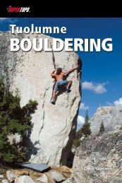
INTRODUCTIONFree Climbing RatingsUSA UIAA France UK AustraliaYosemite Decimal System5.15.25.35.45.55.65.75.85.95.10a5.10b5.10c5.10d5.11a5.11b5.11c5.11d5.12a5.12b5.12c5.12d5.13a5.13b5.13c5.13d5.14a5.14b5.14c5.14d5.15aVIIIIIIIIIIII+IVIV+V-VV+VI-VIVI+VII-VIIVII+VIII-VIII+IX-IXIX+X-XX+XI-XIXI+122+3-33+44+55+6a6a+6b6b+6c6c+7a7a+7b7b+7c7c+8a8a+8b8b+8c8c+9a9a+Two climbers top out on the north summit of Crystal Crag.3B3C4B4C5CMHVD6A6B6CVSE2E5E83C4A4C5A5C6A6B6C7ADSHVSE3E6E93A3B4A4B5B5C6A6C7A7BVDHSE1E4E7E104681012141618192021222324252627282930313233343536Photo by Jediah Porter23HIGH SIERRA CLIMBING: SUPERTOPO
INTRODUCTIONCam Sizes by Brand0 "Ref Size* BD Camalots C4/C3’s Aliens Metolius Cams Trango Big Bros Wild Country Friends0.3" 000 gray .33 black00 grayZero #2-#6 covers .28-.94”0.4" 00 purple0.5" 0 green C3 .375 blue 0 purple 0 red0.6" 1 red.5 green 1 blue .5 orange0.75" .75 yellow 2 yellow.3 blue C4/2 yellow C31 yellow1" 1 red 3 orange.4 gray1.25" .5 purple 1.5 orange 4 red1.5".75 green2 purple 5 black1.75" 2.5 gray 6 green2" 2.5 clear 7 blue1 red1.25 purple1.5 sky1.75 green2 pink2.5" small grey2 yellow3"3 blue3.5" medium maroon2.5 royal3 navy3.5 purple4 black3.5-4.5" large dark blue 1 red4 grey4 silver4.5-5.5" 25 red5 purple*“Ref size” is the optimal crack width for a given cammingunit. It is not the max range given by the manufacturer.5.5-7" 3 green6 green (7.6” max)6 green (7.6” max)7-8" 3 green8-12" 4 blue24FOR CURRENT ROUTE INFORMATION, VISIT WWW.SUPERTOPO.COM
Understanding the mapsDeciphering The <strong>Topo</strong>sINTRODUCTION<strong>Topo</strong> SymbolsRight-facingcornerLeft-facingcornerStraight-incrackGrooveArêteFlakeChimneyRoofLedgeSlabBelaystationPitchlengthOptionalbelayFalsebelay130'1BoltRappelanchorFaceclimbingPine treeOak-like treeBushKnobHoleNotes on Rack• “nuts” refers to any nut, stopper, orchock. “micro”= #1, 2; “sml”= #3-5; “med”=#6-8; “lrg”= #9-13 (BD Stopper number)• for cams, “2 ea .75-1.5” means bringtwo sets of all sizes between .75” and 1.5”.Check the cam size chart to see which camcorresponds to which crack size.Notes on <strong>Topo</strong>• “belay takes .6-1” means while leadingthe pitch save enough .6-1” cams and nutsto build a natural anchor.• a number next to a tree is its height.<strong>Topo</strong> abbreviationsow = offwidthlb = liebackp = fixed pitonR- = somewhat runoutR = runout (dangerous fall)Metric system conversions1 inch = 2.54 centimeters1 foot = 0.305 meters100 feet = 30.5 metersOverview graphicsLow-clearance dirt roadHigh-clearance dirt roadlow-clearance dirt roadhigh-clearance dirt roadRoad or State RouteroadInterstatefederal or state highwayHikers’ trailpark service trailFederal HighwayClimbers’ trailclimbers' trailcross country travelCross-country travelStar Ratings★★★★★ - undisputed classic★★★★ - excellent climb★★★ - good climb★★ - okay climb★ - barely included in this book= = ==== ==== ==10= = ==1025FOR CURRENT ROUTEHIGHINFORMATION,SIERRA CLIMBING:VISIT WWW.SUPERTOPO.COMSUPERTOPO25
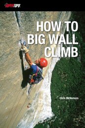
120YosemiteNationalParkTuolumneMeadows108ToiyabeNationalForest38 39 403229 30Twin37 Lakes33 34 353639528120BridgeportMonoLakeLee ViningHigh Sierra Routes1. Lone Pine Peak, North Ridge, p 262. Mt. Whitney, East Face, p 403. Mt. Whitney, East Buttress, p 464. Mt. Whitney, Mountaineer's Route, p 505. Keeler Needle, Harding Route, 516. Mt. Russell, Fishhook Arête, p 587. Mt. Russell, Mithral Dihedral, p 628. Mt. Russell, East Ridge, p 659. Charlotte Dome, South Face, p 7010. Temple Crag, Venusian Blind p 7811. Temple Crag, Moon Goddess Arête, p 8112. Temple Crag, Sun Ribbon Arête, p 8413. Temple Crag, Dark Star, p 8814. Mt. Sill, Swiss Arête, p 9315. North Palisade, U Notch, p 9716. Mt. Goode. North Buttress, p 10017. Cardinal Pinnacle, West Face, p 10618. Mt. Emerson, Southeast Face, p 11019. Mt. Humphreys, East Arête, p 11420. Merriam Peak, North Buttress, p 12221. Bear Creek Spire, Northeast Ridge, p 13222. Bear Creek Spire, North Arête, p 13523. Petite Griffon, Souteast Face, p 13824. Laurel Mountain, Northeast Gully, p 14225. Crystal Crag, North Arête, p 14826. Clyde Minaret, Southeast Face, p 15227. Mt. Ritter, Southeast Glacier, p 15928. Third Pillar of Dana, Regular Route, p 16229. Cathedral Peak, Southeast Buttress, p 16830. Eichorn’s Pinnacle, West Pillar, p 17231. Matthes Crest, Traverse from S to N, p 17732. Tenaya Peak, Northwest Buttress, p 18233. Mt. Conness, West Ridge, p 18934. Mt. Conness, Southwest Face, p 19235. Mt. Conness, North Ridge, p 19536. North Peak, Northeast Couloir, p 20037. Matterhorn Peak, North Arête, p 20438. Incredible Hulk, Sunspot Dihedral, p 21539. Incredible Hulk, Positive Vibrations, p 21840. Incredible Hulk, Red Dihedral, p 222YosemiteValley31140272625MammothLakes203InyoNationalForestCrowleyLakeCALIFORNIANEVADA4124Tom's Place62321 22395SierraNationalForest201918LakeSabrina16SouthLake16817101115 14 12 13BishopBig Pine168resno180180KingsCanyonNationalParkCedarGrove9Independence99Visalia198SequoiaNationalPark6 34 7 82 3 4 51InyoNationalForest395Lone Pine136
Incredible HulkapThe Incredible Hulk (11,120’) is knownfor three things: the best rock in theHigh Sierra, long routes, and incrediblysustained climbing. There are no easyroutes on this face and, unlike mostSierra climbs, the Incredible Hulkremains sustained and challenging fora majority of the pitches (there arefew pitches on any route easier than5.8). The rock is clean and relativelyunfractured and is more reminiscent ofYosemite climbing than the typical HighSierra peak.ApproachThe trailhead for the Incredible Hulk is at TwinLakes, 13 miles west of the town of Bridgeport.Take U.S. 395 to the north end of Bridgeport,turn west onto the Twin Lakes Road and driveto its end in the Mono Village at the west endof the lake. There is a $10 parking fee.The approach takes most climbers 3-4hours from Twin Lakes to the base of theclimb (slighlty longer if you are carrying aheavy pack) and involves 2.5 miles on the maintrail, 2.5 miles on climbers’ trails and crosscountrytravel, and gains about 3,400 feet inelevation. Finding the trailhead is difficult asyou must navigate through the maze-like RVcampground. (If getting a predawn start, scopeout this section the day before.) Follow themain road due west. After after a fire hydrantand before a bridge, turn right off the dirt roadonto the Barney Lakes Trail that leads alongRobinson Creek. If you cross the bridge, thenyou have gone too far. Walk on this trail forapproximately 45 minutes (2.5 miles) untilyou reach a large pine tree with an equallylarge boulder sitting in front of it to the left ofthe trail (see photo.)There may also be cairnsmarking this turn. This should be few hundredyards before Little Slide Canyon.This spot used to be marked with awilderness boundary sign, but the OmnibusPublic Land Management Act of 2009 addeda signifigant parcel of land to the Hoover211HIGH SIERRA CLIMBING: SUPERTOPOWilderness, and the boundary has movedto near the trailhead. This also means thateven though bikes were previously allowedon this first part of the approach, they areno longer permitted.From this point, turn left and walkcross-country southwest, angling towardRobinson Creek. After 100 yards, look for anopportunity to cross the creek on downed logsand beaver dams. If you find yourself in a bigmarsh with tall grass, you should probablyreverse your steps and find a crossing farthereast. After the crossing, walk along the westshore of Robinson Creek for a few hundredfeet, locating a climbers’ trail that enters aprominent grove of pine trees on the east sideof Little Slide Canyon. The trail ascends steepdirt switchbacks through these trees for thenext few hundred yards. Take the time to findthis trail, or you will be bushwhacking foreverup the middle of Little Slide Canyon.At times it will be hard to see where youare going because the Hulk itself will not be inDerek Lee prepares to make the turn off the trail towardsRobinson Creek on the approach to the Incredible Hulk.Photo by Tad Hunt
INCREDIBLE HULKClimbers on the Red Dihedral, the Incredible Hulk.Photo by Pete Clark212FOR CURRENT ROUTE INFORMATION, VISIT WWW.SUPERTOPO.COM
INCREDIBLE HULKview, but from here it is possibleto follow a climber’s trail allthe way to the final talus fieldbelow the Hulk. The switchbackseventually flatten and, afteranother few hundred yards, thetrail ends in talus. Stay on theleft (east) side of the canyon andfollow the edge of the talus untilyou are forced into it. Follow aclimber’s trail through the talus,which leads to a creek crossingwith a little footbridge. Cross thisbridge and continue up the trailon the west (right) side of thecreek, picking your way throughtalus until you reach the base ofthe Hulk.DescentThere are two ways to get off the Hulk: awalk-off or a rap route. The walk-off is mostconvienient for routes that top out on thesummit proper, such as the Red Dihedraland Falling Dihedral, whereas rappelling theVenturi Effect rap stations is more desirable forroutes like Positive Vibes and Sunspot, since itprevents a tedious traverse to the summit.Rap Route: You can rappel this route witha single 70 meter rope, but it just reaches withthe full length of the rope, so knot your ends.From the top of Positive Vibes, walk about 10feet along the ridgeline to the climber’s right.The first rap station is composed of threestoppers, and heads down the Venturi Effectroute. After this first anchor, all the remainingstations are bolted. The second rappel traversesfar to the climber’s left; it is helpful for thefirst person to place a directional to help guidetowards the anchor. After the first four raps,the route joins with Positive Vibes. Rappel thefirst half of this route to the base.Walk-off: This descent still requires onerappel, takes about 45 minutes to get from thesummit to the base of the route, and another2-3 hours to get back to Twin Lakes. Onlyone 50m or 60m rope is required for the onerappel on this descent. From the summit,downclimb the steep 3rd class on the southridge (opposite direction of the climbingroute) for about 300 feet to a rappel anchor(bolts and slings). It helps to locate the rappelThe view from where you will leave the main trail.An aspen grove is just out of view to the right.Photo by Chris McNamaraanchors when you are about 40 feet below thesummit. Make an 80-foot rappel to the notchbetween two gullies: one leads to the north(toward Twin Lakes) one leads to the south(away from Twin Lakes). Take the south gully(the north gully is usually filled with ice andreally dangerous). Downclimb 3rd class for afew hundred yards. When the gully opens up,stay left (staying right sends you over a steepcliff). Eventually gain the main talus and screegully that wraps around to the base of theclimbs. Reverse the approach.If you need motivation for the descent,think of the burgers and fries that await at thetrailhead grill (open until 9 p.m.).CampingDue to the long approach and the difficultnature of the climbs, many parties will wantto bivy near the base of the route. There isexcellent camping at certain points along theapproach next to the river, and there is a largeflat area below Maltby Lake, just below theclimbs. You will need a wilderness permit,available at the Bridgeport Ranger Station.There are also a few different campgroundsthat are located near the trailhead.The Hulk has seen increased popularityin recent years, receiving much more trafficand making it highly likely you will see otherparties up there. This also means there havebeen larger numbers of people camping near213HIGH SIERRA CLIMBING: SUPERTOPO
INCREDIBLE HULKthe base. It has reached the point where humanwaste is becoming a problem in this otherwiseremote and pristine wilderness setting. Do theresponsible thing and pack out your poop inan effort to keep this area nice, and to ensurethat climbers can continue to have access tothis amazing peak. No one wants what hashappened to the Whitney Zone access to beenforced over the entire Sierra, so it is up to usclimbers to keep our own playgrounds clean.Photo by Andy BardonPositive VibrationsSunspot DihedralRed DihedralFalling DihedralVariation214FOR CURRENT ROUTE INFORMATION, VISIT WWW.SUPERTOPO.COM
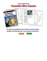
INCREDIBLE HULKRed Dihedral 5.10b HHHHHTime to climb route: 6-10 hoursApproach time: 3-4 hoursDescent time: 3-4 hoursSun exposure: noon to sunsetSummit elevation: 11,120’Height of route: 1,200’Red Dihedral is the most moderate classicroute on the Incredible Hulk but is stillsustained and challenging (only one pitch iseasier than 5.8). The rock is perfect, clean,golden granite and unlike most Sierra climbs,the route requires a fair amount of straightinjamming technique (all the cruxes are oncrack, not face). This is one of those few peaksthat is much larger than it looks. From thebase and approach, the upper pitches are notvisible so when you get up on the climb itkeeps going and going and going.FA: Dale Bard, Mike Farrell, Bob Locke, 6/75.HistoryThough the Incredible Hulk is a west-facingwall well-hidden from any road, it was thesite of a fairly early Yosemite-esque wall climbin the High Sierra. In 1970 the trio of GregDonaldson, Joe Kiskis, and Bob Grow spent acouple of days climbing through the center ofthe face. After completing the route at V, 5.8,A3 they made three rappels down the oppositeside.During the following years, the freeclimbingrevolution took hold in Yosemite. Amongthe revolutionaries, Dale Bard was the first tomake a steady diet of desperate 5.11 cracks. InNumber of pitches by difficultyRed Dihedral Pitch 1 2 3 4 5 6 7 8 9 10 11 12Free Difficulty >5.10• •5.9• • • • • •5.8• • •5.75.6•
Red Dihedral 5.10b HHHHHINCREDIBLE HULKStrategyMost climbers do the climb car-to-car in oneHUGE day. Get a predawn start and movefast. Descending from the summit (specifically,finding the rappel) is difficult and dangerousin the dark. If you are not confident in yourhiking and climbing speed, then camp belowthe climb. The route is moderately popular—you may see two other parties or you may seeno one. A 60m rope is not mandatory but letsyou do the route in as few as eight pitches.The first half of the climb is sustained andfollows major crack systems. The second halfascends more broken rock on easier terrainwith the occasional 5.8 or 5.9 section. The lineis distinct and easy to follow for the first fourpitches. Pitch 2 is the only pitch on the climbthat is difficult to protect.Pitch 4, The Red Dihedral, is one ofthe more memorable pitches in the Sierra.Sustained hand jams lead to wild stemmingmoves through a bulge, followed by an airytraverse right on broken and steep 5.8. Somemay want to bring extra cams in the 1-1.5”range. Save some bigger cams for the belay.Above, the routefinding becomes morechallenging so follow the topo closely and,when in doubt, climb straight up. There aremany options for Pitches 7-10.Once you reach the summit ridge (Belay10) the rock quality deteriorates for the finalpitch. It is crucial to walk over on 3rd classledges to the obvious double cracks. At thetop of the pitch, the wild tunnel through thechimney will be really hard with a pack. This isthe only lame pitch on the climb, and you mayneed to break this into two pitches to avoidrope drag. Do not try to reach the summit bystaying on the west face as the cracks becomeflared and bottoming.RetreatTo retreat, rappel the route. It is easiest toretreat with two ropes, but it is possible toretreat with just one. Because there are nofixed belays on this climb, you will need toleave gear. High Sierra thunderstorms arecommon in the summer. Be sure to get thelatest forecast before heading up on the route.The route can be exposed to very high windsmaking communication difficult.Photo by Chris McNamara224FOR CURRENT ROUTE INFORMATION, VISIT WWW.SUPERTOPO.COM
Red Dihedral 5.10b HHHHHINCREDIBLE HULK225HIGH SIERRA CLIMBING: SUPERTOPO
Red Dihedral 5.10b HHHHHINCREDIBLE HULKTrish McGuire makes short work of the Red Dihedral.Photo by Ken EtzelFOR CURRENT ROUTE INFORMATION, VISIT WWW.SUPERTOPO.COM226
TICKLISTThe Budding Alpine Climber TicklistapIf you are just emerging into the alpine climbing realm, there are still plenty of worthyadventures to be had. Some of the most fun and classic climbs in the Sierra come with an easyrating. Below we have listed, in order, the easiest and most accessible peaks to help familiarizeyourself with the area and the task of summiting technical apline peaks. Work your way up thislist, and you will be tackling more difficult challenges in no time.z Tenaya Peak, Northwest Buttress 5.5 HHHH page 185z Cathedral Peak, Southeast Buttress 5.6 HHHHH page 169z Laurel Mountain, Northeast Gully 5.2 HHH page 147z Mt. Emerson, Southeast Face 5.4 HHHH page 113z Crystal Crag, North Arête 5.7 HHH page 151z Petite Griffon, Southeast Face 5.7 HHHH page 140z Mt. Sill, Swiss Arête 5.7 HHHHH page 94Sierra Snow ClimbsapFor those who seek out mountain adventures even in winter, there are several fun climbs upsnow and ice. Some routes, such as the Mountaineer’s route, can be a rocky talus climb insummer, but in spring or fall can be a low-angle ascent best done with a tool and crampons.z Mt. Whitney, Mountaineer’s Route 3rd Class HH page 50z Mt. Ritter, Southeast Glacier Route 3rd Class HHH page 161z North Peak, Northeast Couloir, AI2, 4th class HHHH page 203z North Palisade, U Notch AI2, 4th Class HHH page 98229HIGH SIERRA CLIMBING: SUPERTOPO
TICKLISTThe Sierra Hardman/woman TicklistapMaybe alpine climbing is old news to you – been there, done that, complete with spray onthe internet. But have you proven yourself on the hardest gems in the Sierra? If you’ve alreadychecked these routes off, then step it up and do them all car-to-car in a day...z Cardinal Pinnacle, West Face 5.10a HHHH page 107z Clyde Minaret, Southeast Face (Direct Start) 5.10 HHHH page 155z Mt. Russell, Mithral Dihedral 5.10a HHHHH page 63z Temple Crag, Sun Ribbon Arête 5.10a HHHHH page 85z Third Pillar of Dana, Regular Route 5.10b HHHHH page 165z Incredible Hulk, Red Dihedral 5.10b HHHHH page 223z Merriam Peak, North Buttress 5.10b HHHH page 125z Keeler Needle, Harding Route 5.10c HHH page 52z Temple Crag, Dark Star 5.10c HHH page 89z Incredible Hulk, Positive Vibrations 5.11a HHHHH page 219z Incredible Hulk, Sunspot Dihedral 5.11b HHHH page 215Impressive Link-upsapA fun Sierra challenge for fast moving parties is to complete link-ups of technical climbs. Usuallythis involves soloing either large portions or entire routes in order to complete the objective inone day. Here are a few worthy accomplishments that combine climbs we cover in this book:z Mt. Whitney (East Face and East Buttress, descending Mountaineer’s Route twice)z Mt. Russell (Fishhook Arête and Mithral Dihedral. Even better: descend the East Ridgeafterwards.)z Triple Crown (Tenaya Peak, Full Matthes Crest, & Cathedral Peak)z North Peak - Mt. Conness - Mt. Conness (North Peak to Conness North Ridge toConness West Ridge)FOR CURRENT ROUTE INFORMATION, VISIT WWW.SUPERTOPO.COM230
INDEXClimbs by Ratingapz Mt. Russell, East Ridge 3rd class HHHH page 66z Mt. Whitney, Mountaineer’s Route 3rd Class HH page 50z Mt. Ritter, Southeast Glacier Route 3rd Class HHH page 161z North Peak, Northeast Couloir, AI2, 4th class HHHH page 203z North Palisade, U Notch AI2, 4th Class HHH page 98z Laurel Mountain, Northeast Gully 5.2 HHH page 147z Mt. Emerson, Southeast Face 5.4 HHHH page 113z Bear Creek Spire, Northeast Ridge 5.5 HHHH page 136z Tenaya Peak, Northwest Buttress 5.5 HHHH page 185z Lone Pine Peak, North Ridge 5.5 HHH page 29z Mt. Humphreys, East Arête 5.5 HHHH page 118z Cathedral Peak, Southeast Buttress 5.6 HHHHH page 169z Mt. Conness, West Ridge 5.6 HHHHH page 190z Mt. Conness, North Ridge 5.6 HHHH page 199z Crystal Crag, North Arête 5.7 HHH page 151z Matterhorn Peak, North Arête 5.7 HHH page 207z Matthes Crest, Traverse from South to North 5.7 HHHHH page 179z Mt. Whitney, East Buttress 5.7 HHHHH page 47z Mt. Whitney, East Face 5.7 HHHHH page 41z Petite Griffon, Southeast Face 5.7 HHHH page 140z Mt. Sill, Swiss Arête 5.7 HHHHH page 94z Temple Crag, Venusian Blind 5.7 HHHHH page 79z Temple Crag, Moon Goddess Arête 5.8 HHHH page 82z Charlotte Dome, South Face 5.8 HHHHH page 71z Bear Creek Spire, North Arête 5.8 HHHH page 133z Clyde Minaret, Southeast Face 5.8 HHHH page 155z Eichorn’s Pinnacle, West Pillar 5.9 HHH page 174z Mt. Russell, Fishhook Arête 5.9 HHHHH page 59z Mt. Goode, North Buttress 5.9 HHH page 104z Cardinal Pinnacle, West Face 5.10a HHHH page 107z Incredible Hulk, Falling Dihedral 5.10a HHH page 227z Mt. Russell, Mithral Dihedral 5.10a HHHHH page 63z Temple Crag, Sun Ribbon Arête 5.10a HHHHH page 85z Third Pillar of Dana, Regular Route 5.10b HHHHH page 165z Incredible Hulk, Red Dihedral 5.10b HHHHH page 223z Merriam Peak, North Buttress 5.10b HHHH page 125z Mt. Conness, Southwest Face 5.10c HHHH page 193z Keeler Needle, Harding Route 5.10c HHH page 52z Temple Crag, Dark Star 5.10c HHH page 89z Incredible Hulk, Positive Vibrations 5.11a HHHHH page 219z Incredible Hulk, Sunspot Dihedral 5.11b HHHH page 215231HIGH SIERRA CLIMBING: SUPERTOPO
INDEXClimbs by Nameapz Bear Creek Spire, Northeast Ridge 5.5 HHHH page 136z Bear Creek Spire, North Arête 5.8 HHHH page 133z Cardinal Pinnacle, West Face 5.10a HHHH page 107z Cathedral Peak, Southeast Buttress 5.6 HHHHH page 169z Charlotte Dome, South Face 5.8 HHHHH page 71z Clyde Minaret, Southeast Face 5.8 HHHH page 155z Crystal Crag, North Arête 5.7 HHH page 151z Eichorn’s Pinnacle, West Pillar 5.9 HHH page 174z Incredible Hulk, Falling Dihedral 5.10a HHH page 227z Incredible Hulk, Positive Vibrations 5.11a HHHHH page 219z Incredible Hulk, Red Dihedral 5.10b HHHHH page 223z Incredible Hulk, Sunspot Dihedral 5.11b HHHH page 215z Keeler Needle, Harding Route 5.10c HHH page 52z Laurel Mountain, Northeast Gully 5.2 HHH page 147z Lone Pine Peak, North Ridge 5.5 HHH page 29z Matterhorn Peak, North Arête 5.7 HHH page 207z Matthes Crest, Traverse from South to North 5.7 HHHHH page 179z Merriam Peak, North Buttress 5.10b HHHH page 125z Mt. Conness, North Ridge 5.6 HHHH page 199z Mt. Conness, Southwest Face 5.10c HHHH page 193z Mt. Conness, West Ridge 5.6 HHHHH page 190z Mt. Emerson, Southeast Face 5.4 HHHH page 113z Mt. Goode, North Buttress 5.9 HHH page 104z Mt. Humphreys, East Arête 5.5 HHHH page 118z Mt. Ritter, Southeast Glacier Route 3rd Class HHH page 161z Mt. Russell, East Ridge 3rd class HHHH page 66z Mt. Russell, Fishhook Arête 5.9 HHHHH page 59z Mt. Russell, Mithral Dihedral 5.10a HHHHH page 63z Mt. Sill, Swiss Arête 5.7 HHHHH page 94z Mt. Whitney, East Buttress 5.7 HHHHH page 47z Mt. Whitney, East Face 5.7 HHHHH page 41z Mt. Whitney, Mountaineer’s Route 3rd Class HH page 50z North Palisade, U Notch AI2, 4th Class HHH page 98z North Peak, Northeast Couloir, AI2, 4th class HHHH page 203z Petite Griffon, Southeast Face 5.7 HHHH page 140z Tenaya Peak, Northwest Buttress 5.5 HHHH page 185z Temple Crag, Dark Star 5.10c HHH page 89z Temple Crag, Sun Ribbon Arête 5.10a HHHHH page 85z Temple Crag, Moon Goddess Arête 5.8 HHHH page 82z Temple Crag, Venusian Blind 5.7 HHHHH page 79z Third Pillar of Dana, Regular Route 5.10b HHHHH page 165232FOR CURRENT ROUTE INFORMATION, VISIT WWW.SUPERTOPO.COM