Planning Scheme Provisions (3.9 MB) - Cairns Regional Council
Planning Scheme Provisions (3.9 MB) - Cairns Regional Council Planning Scheme Provisions (3.9 MB) - Cairns Regional Council
-31 -Where, by virtue of this Scheme -i. development on land, the erection of a building or other structure on land or the useof land may be undertaken or carried out without the Consent of the Council; orii.because of an approval, decision or Consent given by the Council, development onland, the erection of a building or other structure on land or the use of land may beundertaken or carried out;such development, building or use shall nevertheless -(a)be subject to all relevant laws and Local Laws; and(l~) be subject to those provisions of this Scheme which are expressed to apply in suchcases.The obligation of compliance with this Scheme lies upon the applicant or, if there is noapplicant, upon the person undertaking or carrying out or proposing to undertake or carryout development on land, the erection of a building or other structure on land or the use ofland.The Council may, by notice in writing, require the owner of any premises to which anyprovision of this Scheme applies to comply with that provision, or to make an applicationto the Council for an approval decision or Consent required to be given or made by itunder this Scheme.
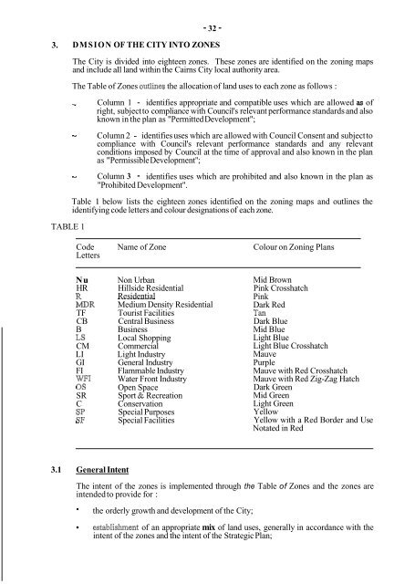
- 32 -3. DMSION OF THE CITY INTO ZONESThe City is divided into eighteen zones. These zones are identified on the zoning mapsand include all land within the Cairns City local authority area.The Table of Zones outlines the allocation of land uses to each zone as follows :I Column--TABLE 11 - identifies appropriate and compatible uses which are allowed as ofright, subject to compliance with Council's relevant performance standards and alsoknown in the plan as "Permitted Development";Column 2 - identifies uses which are allowed with Council Consent and subject tocompliance with Council's relevant performance standards and any relevantconditions imposed by Council at the time of approval and also known in the planas "Permissible Development";Column 3 - identifies uses which are prohibited and also known in the plan as"Prohibited Development".Table 1 below lists the eighteen zones identified on the zoning maps and outlines theidentifying code letters and colour designations of each zone.CodeLettersName of ZoneColour on Zoning PlansNuHRRMDRTFCBBLSCMLIGIFIWFI0sSRCSPSFNon UrbanHillside ResidentialResidential~~~Medium Density ResidentialTourist FacilitiesCentral BusinessBusinessLocal ShoppingCommercialLight IndustryGeneral IndustryFlammable IndustryWater Front IndustryOpen SpaceSport & RecreationConservationSpecial PurposesSpecial FacilitiesMid BrownPink CrosshatchPinkDark RedTanDark BlueMid BlueLight BlueLight Blue CrosshatchMauvePurpleMauve with Red CrosshatchMauve with Red Zig-Zag HatchDark GreenMid GreenLight GreenYellowYellow with a Red Border and UseNotated in Red3.1 General IntentThe intent of the zones is implemented through the Table of Zones and the zones areintended to provide for :- the orderly growth and development of the City;establishment of an appropriate mix of land uses, generally in accordance with theintent of the zones and the intent of the Strategic Plan;
- Page 1 and 2: aPLANNING SCHEME PROVISIONS-.c
- Page 3 and 4: PLANNING SCHEME PROVISIONSCONTENTS1
- Page 5 and 6: -3-CONTENTS5. PROVISIONS FOR SUBDMS
- Page 7 and 8: -2-Appointed DayThe day upon which
- Page 9 and 10: -4-Gross Ploor AreaThe sum of the a
- Page 11 and 12: -6-Minor Building WorkMeans erectio
- Page 14 and 15: -9-Tall BuildingA Tall Building is
- Page 16 and 17: Caretakers Residence- 11 -Any resid
- Page 18 and 19: Restoration of any of the following
- Page 20 and 21: -15-Heavy Vehicle ParkingAny premis
- Page 22 and 23: - 17-APPENDIX 4Amusement halls and
- Page 24 and 25: - 19-APPENDIX 6Industries listed in
- Page 26 and 27: Processing of qbber- 21 -Processing
- Page 28 and 29: -23 -Local UtilitiesAny premises us
- Page 30 and 31: - 25 -Ski slopeSpeedwaySporting are
- Page 32 and 33: Public Utilities- 27 -Any premises
- Page 34 and 35: Single Room Occupancy- 29 -Any prem
- Page 38 and 39: - 33 -- distribution, in suitable l
- Page 40 and 41: - 35 -Column 1 Column 2 Column 3Per
- Page 42 and 43: -37-Column 1 Column 2 Column 3Permi
- Page 44 and 45: - 39 -Column 1 Column 2 Column 3Per
- Page 46 and 47: -41 -Column 1 Column 2 Column 3Perm
- Page 48 and 49: -43 -Column 1Column 2 Column 3Permi
- Page 50 and 51: -45-Column 1 Column 2 Column 3Permi
- Page 52 and 53: - 47 -3.3.8 Local Shopping ZoneInte
- Page 54 and 55: -49-TABLE3.3.9 Commercial ZoneInten
- Page 56 and 57: -51 -3.3.10 Light Industry ZoneInte
- Page 58 and 59: - 53 -TABLE3.3.11 General Industry
- Page 60 and 61: - 55 -3.3.12 Flammable Industry Zon
- Page 62 and 63: -57-3.3.13 Waterfront Industry Zone
- Page 64 and 65: ~-59-3.3.14 Open Space ZoneIntentTh
- Page 66 and 67: - 62 -Column 1 Column 2 Column 3Per
- Page 68 and 69: - 64 -Column 1 Column 2 Column 3Per
- Page 70 and 71: - 66 -Column 1 Column 2 Column 3Per
- Page 72 and 73: -68-4. PERFORMANCE STANDARDS AND SP
- Page 74 and 75: - 70 -4.3 Parlcing, LoadingKJnloadi
- Page 76 and 77: - 72 -COLUMN 1PurposeCOLUMN 2Mium N
- Page 78 and 79: - 74 -COLUMN 1Purpose- ExtractiveWa
- Page 80 and 81: - 76 -COLUMN 1PurposePlant NurseryP
- Page 82 and 83: - 78 -COLUMN 1 COLUMN 2PurposeVehic
- Page 84 and 85: -79-CENTRAL BUSINESS DISTRICTFIGURE
- 32 -3. DMSION OF THE CITY INTO ZONESThe City is divided into eighteen zones. These zones are identified on the zoning mapsand include all land within the <strong>Cairns</strong> City local authority area.The Table of Zones outlines the allocation of land uses to each zone as follows :I Column--TABLE 11 - identifies appropriate and compatible uses which are allowed as ofright, subject to compliance with <strong>Council</strong>'s relevant performance standards and alsoknown in the plan as "Permitted Development";Column 2 - identifies uses which are allowed with <strong>Council</strong> Consent and subject tocompliance with <strong>Council</strong>'s relevant performance standards and any relevantconditions imposed by <strong>Council</strong> at the time of approval and also known in the planas "Permissible Development";Column 3 - identifies uses which are prohibited and also known in the plan as"Prohibited Development".Table 1 below lists the eighteen zones identified on the zoning maps and outlines theidentifying code letters and colour designations of each zone.CodeLettersName of ZoneColour on Zoning PlansNuHRRMDRTFCBBLSCMLIGIFIWFI0sSRCSPSFNon UrbanHillside ResidentialResidential~~~Medium Density ResidentialTourist FacilitiesCentral BusinessBusinessLocal ShoppingCommercialLight IndustryGeneral IndustryFlammable IndustryWater Front IndustryOpen SpaceSport & RecreationConservationSpecial PurposesSpecial FacilitiesMid BrownPink CrosshatchPinkDark RedTanDark BlueMid BlueLight BlueLight Blue CrosshatchMauvePurpleMauve with Red CrosshatchMauve with Red Zig-Zag HatchDark GreenMid GreenLight GreenYellowYellow with a Red Border and UseNotated in Red3.1 General IntentThe intent of the zones is implemented through the Table of Zones and the zones areintended to provide for :- the orderly growth and development of the City;establishment of an appropriate mix of land uses, generally in accordance with theintent of the zones and the intent of the Strategic Plan;


