East Dorset Landscape Character Assessment - Dorsetforyou.com
East Dorset Landscape Character Assessment - Dorsetforyou.com East Dorset Landscape Character Assessment - Dorsetforyou.com
• Narrow, winding lanes throughout the area, with high, densehedgerows• Extensive network of public footpaths and woodland and othertracks• Farmhouses and other modest rural dwellings, few major historicbuildings or churches• General absence of archaeological remains, except for tumuli onhilltops• Heavy concentration of Ancient Woodlands• Quiet, peaceful countryside largely unaffected by moderndevelopmentPhoto: Peter MounceHillbutts looking eastwards towards Wimborne, Q.E School to the right of the photoKey Characteristics• Undulating landform, punctuated by hilltops• Heavily influenced by woods, copses and hedgerow treescreating an irregular patchwork• Absence of major roads• Irregular road pattern, having an east-west emphasis with shortnorth-south linksEast Dorset District Council District Landscape Character Assessment 200831
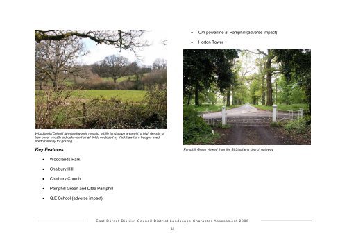
• O/h powerline at Pamphill (adverse impact)• Horton TowerWoodlands/Colehill farmland/woods mosaic: a hilly landscape area with a high density oftree cover -mostly old oaks- and small fields enclosed by thick hawthorn hedges usedpredominantly for grazing.Key FeaturesPamphill Green viewed from the St Stephens church gateway• Woodlands Park• Chalbury Hill• Chalbury Church• Pamphill Green and Little Pamphill• Q.E School (adverse impact)East Dorset District Council District Landscape Character Assessment 200832
- Page 1: East Dorset Landscape Character Ass
- Page 7 and 8: Regional guidanceThe draft Regional
- Page 9 and 10: Area of Outstanding Beauty (AONB) p
- Page 11 and 12: 1) Chase WoodsContextLandscape Type
- Page 13 and 14: 2) East Dorset Downs/South Blandfor
- Page 15 and 16: distinctive profile of Badbury Ring
- Page 17 and 18: To the north east of this valley th
- Page 19 and 20: Handley Road. The strong contrast b
- Page 21 and 22: 3) Allen Valley Flat water meadows
- Page 23 and 24: 4) Monkton Up Wimborne ValleyContex
- Page 25 and 26: 5) Gussage ValleyContextLandscape C
- Page 27 and 28: 6) Crichel ValleyContextLandscape C
- Page 29 and 30: 7) Lower Winterborne ValleyContextL
- Page 31 and 32: • A31 Trunk road - has an adverse
- Page 33: Horton Tower, a Grade II* listed bu
- Page 37 and 38: View of Henbury Plantation from Bla
- Page 39 and 40: that mark the former floodplain. Ho
- Page 41 and 42: The Stour looking north eastwards f
- Page 43 and 44: that lies within Poole is set on a
- Page 45 and 46: 13) Hampreston River TerraceContext
- Page 47 and 48: golf course suggest this character
- Page 49 and 50: • Urban influencesKey Features16)
- Page 51 and 52: Key CharacteristicsKey Features•
- Page 53 and 54: 18) Ringwood-Hurn Forest/Heath Mosa
- Page 55 and 56: Forest which reaches back into the
- Page 57 and 58: appearance, it has more in common w
- Page 59 and 60: 21) Horton Common-Three Legged Cros
- Page 61 and 62: a National Nature Reserve the heath
- Page 63 and 64: Stour Valley northwards to Alderhol
- Page 65 and 66: Historically the River was an impor
- Page 67 and 68: Landscape DescriptionUnit boundarie
- Page 69 and 70: Appendix 2 Appendix 3© Crown Copyr
• O/h powerline at Pamphill (adverse impact)• Horton TowerWoodlands/Colehill farmland/woods mosaic: a hilly landscape area with a high density oftree cover -mostly old oaks- and small fields enclosed by thick hawthorn hedges usedpredominantly for grazing.Key FeaturesPamphill Green viewed from the St Stephens church gateway• Woodlands Park• Chalbury Hill• Chalbury Church• Pamphill Green and Little Pamphill• Q.E School (adverse impact)<strong>East</strong> <strong>Dorset</strong> District Council District <strong>Landscape</strong> <strong>Character</strong> <strong>Assessment</strong> 200832


