East Dorset Landscape Character Assessment - Dorsetforyou.com
East Dorset Landscape Character Assessment - Dorsetforyou.com
East Dorset Landscape Character Assessment - Dorsetforyou.com
- No tags were found...

Create successful ePaper yourself
Turn your PDF publications into a flip-book with our unique Google optimized e-Paper software.
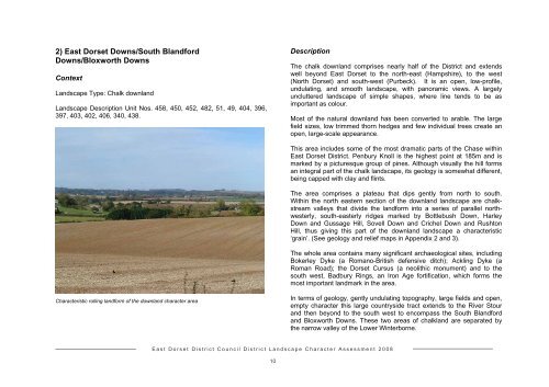
2) <strong>East</strong> <strong>Dorset</strong> Downs/South BlandfordDowns/Bloxworth DownsContext<strong>Landscape</strong> Type: Chalk downland<strong>Landscape</strong> Description Unit Nos. 458, 450, 452, 482, 51, 49, 404, 396,397, 403, 402, 406, 340, 438.DescriptionThe chalk downland <strong>com</strong>prises nearly half of the District and extendswell beyond <strong>East</strong> <strong>Dorset</strong> to the north-east (Hampshire), to the west(North <strong>Dorset</strong>) and south-west (Purbeck). It is an open, low-profile,undulating, and smooth landscape, with panoramic views. A largelyuncluttered landscape of simple shapes, where line tends to be asimportant as colour.Most of the natural downland has been converted to arable. The largefield sizes, low trimmed thorn hedges and few individual trees create anopen, large-scale appearance.This area includes some of the most dramatic parts of the Chase within<strong>East</strong> <strong>Dorset</strong> District. Penbury Knoll is the highest point at 185m and ismarked by a picturesque group of pines. Although visually the hill formsan integral part of the chalk landscape, its geology is somewhat different,being capped with clay and flints.The area <strong>com</strong>prises a plateau that dips gently from north to south.Within the north eastern section of the downland landscape are chalkstreamvalleys that divide the landform into a series of parallel northwesterly,south-easterly ridges marked by Bottlebush Down, HarleyDown and Gussage Hill, Sovell Down and Crichel Down and RushtonHill, thus giving this part of the downland landscape a characteristic‘grain’. (See geology and relief maps in Appendix 2 and 3).The whole area contains many significant archaeological sites, includingBokerley Dyke (a Romano-British defensive ditch); Ackling Dyke (aRoman Road); the <strong>Dorset</strong> Cursus (a neolithic monument) and to thesouth west, Badbury Rings, an Iron Age fortification, which forms themost important landmark in the area.<strong>Character</strong>istic rolling landform of the downland character areaIn terms of geology, gently undulating topography, large fields and open,empty character this large countryside tract extends to the River Stourand then beyond to the south west to en<strong>com</strong>pass the South Blandfordand Bloxworth Downs. These two areas of chalkland are separated bythe narrow valley of the Lower Winterborne.<strong>East</strong> <strong>Dorset</strong> District Council District <strong>Landscape</strong> <strong>Character</strong> <strong>Assessment</strong> 200810