ANGUS LOCAL PLAN REVIEW FINALISED PLAN - Angus Council
ANGUS LOCAL PLAN REVIEW FINALISED PLAN - Angus Council ANGUS LOCAL PLAN REVIEW FINALISED PLAN - Angus Council
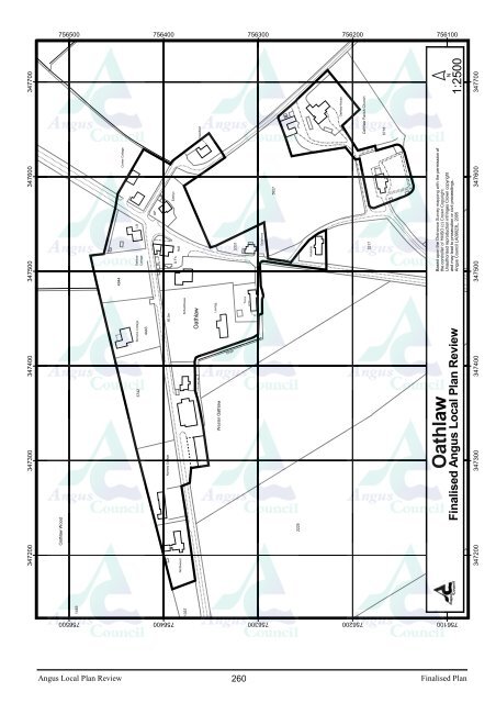
7565007564007563007562007561003475003476003477004944Corner CottageOathlawCottageLBGPD FnHallEastlynViewfield5331Grasmere5927KirkstileOathlaw House5217Oathlaw Parish Church6718Based upon Based the upon Ordnance upon the the Ordnance Survey mapping Survey Survey mapping with the permission with with the the permission ofof ofthe controller the the controller of HMSO of (c) HMSO of Crown HMSO (c) Copyright. Crown (c) Crown Copyright.Unauthorised Unauthorised reproduction reproduction infringes infringes Crown copyright Crown Crown copyrightand may and lead and may to may prosecution lead lead to prosecution to or civil proceedings. or civil or civil proceedings.Angus Council Angus Angus LA09023L, Council Council LA09023L, 2003 2005 20031:2500347500347600N3477003473003474003742Benshie Cottage4443Nursery Cottage80.5mOathlawSchoolhouseWester OathlawLeariggDrainTerraOathlawBasedFinalised Angus Local Plan Review347300347400Oathlaw Wood2225347200Northwood34720014491337756100756200756300756400756500Angus Local Plan Review260Finalised Plan
513A 9262261412202822241426341614a441461350525811256041751700751600GPada751500751400751300342900343000ETL006465.1mBM 64.67m64.3mA 926Dunvegan12ST NINIANSROADEl Sub StaST NINIANS ROADPadanaramPlaying FieldPumphouseMP .75Based upon Based the upon Ordnance upon the the Ordnance Survey mapping Survey Survey mapping with the permission with with the the permission ofof ofthe controller the the controller of HMSO of (c) HMSO of Crown HMSO (c) Copyright. (c) Crown Crown Copyright.Unauthorised Unauthorised reproduction reproduction infringes infringes Crown copyright Crown Crown copyrightand may and lead and may to may prosecution lead lead to prosecution to or civil proceedings. or civil or civil proceedings.Angus Council Angus Angus LA09023L, Council LA09023L, 2003 2005 20031:2500SPDrain342900343000N34280045 47 49 51342800342600342700LB TCB REDFORD ROAD66.7mVillage Hall18265482 72 706634PadanaramBasedTrackFinalised Angus Local Plan Review342600342700446260565533BM 67.57m342500342500751300751400751500751600751700Angus Local Plan Review261Finalised Plan
- Page 216 and 217: Fk1 : Housing - Millgate 3Approxima
- Page 218 and 219: 2171279Playground235412A 9281774690
- Page 220 and 221: HOUSINGEXISTING SITES5. Sites with
- Page 222 and 223: 12750900750800750700750600750500750
- Page 224 and 225: 2191203Track123630211437381 to 8101
- Page 226 and 227: 22216A 92A 92433925BM 30.03m2749700
- Page 228 and 229: Ik1 : Housing - Land to rear of Lun
- Page 230 and 231: 11282495637135827646749600749400749
- Page 232 and 233: NEW ALLOCATIONS6. Table 2 summarise
- Page 234 and 235: 74430074420074410074400074390074380
- Page 236 and 237: 75595075590075585075580075575075570
- Page 238 and 239: 333800333700333600755200Reservoir(c
- Page 240 and 241: of764550764500764450764400764350764
- Page 242 and 243: Track162131261031111429227318Pav191
- Page 244 and 245: HOUSINGNEW ALLOCATIONS4. Table 1 su
- Page 246 and 247: 9.3mIssuesAll Weather PitchSiloEast
- Page 248 and 249: 31231915177131712121161824151262130
- Page 250 and 251: 417116Drain175250075240075230000307
- Page 252 and 253: 71753400753300753200753100753000339
- Page 254 and 255: 75930075920075910075900075890075880
- Page 256 and 257: 2928573271136AFFLECK GDNS2739000738
- Page 258 and 259: 227374005873730073720073710046.1m1:
- Page 260 and 261: 15559961267364007363007362007361007
- Page 262 and 263: 73780073770073760073750073740034240
- Page 264 and 265: 76410076400076390076380076370076360
- Page 268 and 269: 73605073600073595073590073585073580
- Page 270 and 271: 8064112412FBs1118225315626274892579
- Page 272 and 273: 76600076595076590076585076580076575
- Page 274 and 275: 74905074900074895074890074885074880
- Page 276 and 277: 111a124ROADLB15SMPostBaldragon43714
- Page 278 and 279: 20181437585007584007583007582007581
- Page 280 and 281: 76460076450076440076430076420035410
- Page 282 and 283: 44a1394a413353324911092384846424056
- Page 284 and 285: 3134CR13CR4123162155176432187753000
- Page 286 and 287: 64.3mSmiddy FarmhouseTrack8734 GP82
- Page 288: Development boundarySafeguard areas
- Page 291 and 292: PART 5: Implementation, Monitoring
- Page 293 and 294: Introduction5.1 This local plan pro
- Page 295 and 296: acceptable and will form one of the
- Page 297 and 298: Review5.15 The Finalised Angus Loca
- Page 299 and 300: PART 6: AppendicesPage1. Developmen
- Page 301 and 302: APPENDIX 1 - DEVELOPMENTS REQUIRING
- Page 303 and 304: Appendix 2 : Housing Land Supply in
- Page 305 and 306: Sites with Planning Permission at J
- Page 307 and 308: Appendix 3L1 : Letham Unadopted Roa
- Page 309 and 310: Poilcy L1 LETHAM - UNADOPTED ROADS
- Page 311 and 312: Finalised AngusLocal Plan ReviewSec
- Page 313 and 314: APPENDIX 5Profile of AngusAREA (ha)
- Page 315: Gross Earnings 2003(New Earnings Su
7565007564007563007562007561003475003476003477004944Corner CottageOathlawCottageLBGPD FnHallEastlynViewfield5331Grasmere5927KirkstileOathlaw House5217Oathlaw Parish Church6718Based upon Based the upon Ordnance upon the the Ordnance Survey mapping Survey Survey mapping with the permission with with the the permission ofof ofthe controller the the controller of HMSO of (c) HMSO of Crown HMSO (c) Copyright. Crown (c) Crown Copyright.Unauthorised Unauthorised reproduction reproduction infringes infringes Crown copyright Crown Crown copyrightand may and lead and may to may prosecution lead lead to prosecution to or civil proceedings. or civil or civil proceedings.<strong>Angus</strong> <strong>Council</strong> <strong>Angus</strong> <strong>Angus</strong> LA09023L, <strong>Council</strong> <strong>Council</strong> LA09023L, 2003 2005 20031:2500347500347600N3477003473003474003742Benshie Cottage4443Nursery Cottage80.5mOathlawSchoolhouseWester OathlawLeariggDrainTerraOathlawBasedFinalised <strong>Angus</strong> Local Plan Review347300347400Oathlaw Wood2225347200Northwood34720014491337756100756200756300756400756500<strong>Angus</strong> Local Plan Review260Finalised Plan


