landslide management using geospatial technology (lmgt)
landslide management using geospatial technology (lmgt) landslide management using geospatial technology (lmgt)
(Cont’d)Analysis results of rock samplesOutcrop Locations RS1 RS2 RS3 RS4 RS5 RS6 RS7CoordinatesLithology6°1'16.60"U/116°6'45.64"TInterbeddedsandstoneshale5°56'23.85"U/116°3'27.37"TInterbeddedsandstone-shale5°58'18.41"U/116°4'37.13"TInterbeddedsandstone-shale5°59'13.81"U/116°4'37.04"TInterbeddedsandstoneshale5°58'31.61"U/116°4'10.30"TInterbeddedsandstoneshale6°6'59.46"U/116°9'53.46"TInterbeddedsandstoneshale5°56'50.70"U/116°5'44.11"TInterbeddedsandstone-shaleWeathering grade II to V IV to V III to V III to IV III to IV III to IV III to IVRock Quality Designation (RQD) (%) 9 – 87 13 – 34 6 – 63 38 – 77 12 – 65 15 – 35 12 – 28Point load strength index, I s(50) 0.42 – 4.80 1.04 – 5.20 3.12 – 11.45 8.33 – 13.53 0.22 – 1.76 0.81 – 3.67 0.62 – 2.39Uniaxial compressive strengthcorrelation, UCS = 24 I S (50) (mPa)10.19 – 115.20 24.99 – 124.90 74.94 – 274.79199.85 –324.755.28 – 42.24 19.44 – 88.08 14.88 – 57.36Outcrop Locations RS8 RS9 RS10 RS11 RS12 RS13 RS14CoordinatesLithology5°55'10.06"U/116°6'51.31"TInterbeddedsandstoneshale5°55'2.07"U/116°5'41.20"TInterbeddedsandstone-shale5°58'11.14"U/116°5'29.89"TInterbeddedsandstone-shale5°55'56.11"U/116°7'1.67"TInterbeddedsandstoneshale6°2'40.14"U/116°9'26.51"TInterbeddedsandstoneshale6°0'16.50" U/116°7'51.67"TInterbeddedsandstoneshale6°6'7.09"U/116°10'29.69"TInterbeddedsandstone-shaleWeathering grade III to IV IV to V III to IV III to IV III to IV III to V II to IVRock Quality Designation (RQD) (%) 18 – 38 10 – 25 12 – 43 17 – 31 18 – 45 5 – 25 16 – 86Point load strength index, I s(50) 0.08 – 1.12 0.04 – 0.16 0.76 – 4.40 0.12 – 0.44 0.04 – 0.32 1.04 – 5.20 0.10 – 0.73Uniaxial compressive strengthcorrelation, UCS = 24 I S (50) (mPa)1.92 – 26.88 0.96 – 3.84 18.24 – 105.60 2.88 – 10.56 0.96 – 7.68 24.99 – 124.90 2.40 – 17.52Outcrop Locations RS15 RS16 RS17 RS18 RS19 RS20CoordinatesLithology5°55'10.27"U/116°3'39.42"TInterbeddedsandstoneshale6°7'15.00"U/116°12'30.38"TInterbeddedsandstone-shale6°0'56.04"U/116° 7'36.55"TInterbeddedsandstone-shale6°0'27.16"U/116° 8'54.60"TInterbeddedsandstoneshale6°0'26.38"U/116°7'49.42"TInterbeddedsandstoneshale5°58'26.97"U/116°4'55.00"TInterbeddedsandstoneshaleWeathering grade III to V III to IV IV to V III to IV III to V II to IVRock Quality Designation (RQD) (%) 8 – 50 12 – 35 10 – 20 22 – 55 15 – 40 12 – 37Point load strength index, Is(50) 0.14 – 0.52 0.38 – 7.68 0.55 – 2.89 1.35 – 2.71 0.48 – 1.25 1.04 – 10.41Uniaxial compressive strengthcorrelation, UCS = 24 IS (50) (mPa)3.36 – 12.48 9.12 – 184.32 13.20 – 69.36 32.48 – 64.95 11.52 – 30.00 24.98 – 249.81
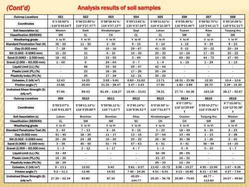
(Cont’d)Analysis results of soil samplesOutcrop Locations SS1 SS2 SS3 SS4 SS5 SS6 SS7 SS8Coordinates6°1'16.60"U/116°6'45.64"T5°56'23.85"U/116°3'27.37"T5°58'18.41"U/116°4'37.13"T5°59'13.81"U/116°4'37.04"T5°58'31.61"U/116°4'10.30"T6°6'59.46"U/116°9'53.46"T5°56'50.70"U/116°5'44.11"T5°55'10.06"U/116°6'51.31"TSoil Association (s) Weston Dalit Kinabatangan Sapi Lokan Tuaran Klias Tanjung AruClassification (BS5930) SM CL CH CL CL SM SC SMWeathering grade V to VI V to VI V to VI V to VI V to VI V to VI V to VI V to VIStandard Penetration Test (N) 36 – 50 11 – 50 3 – 50 9 – 15 5 – 14 1 - 15 9 – 29 9 – 23Clay (0.002 mm) 7 – 18 50 10 – 16 29 – 67 41 – 55 5 - 15 10 – 22 20 – 24Silt (0.002 - 0.0063 mm) 10 – 20 31 6 – 10 10 – 30 20 – 30 10 – 24 17 – 25 20 – 22Sand (0.0063 – 2.000 mm) 18 – 62 13 33 – 50 3 – 60 14 – 35 60 – 80 44 – 72 47 – 90Gravel (2.000 – 63.000 mm) 1 – 60 6 24 – 64 0 – 7 1 – 4 1 – 15 1 – 24 1 – 13Liquid Limit (LL) (%) - 48 33 – 50 29 – 47 42 – 44 - - -Plastic Limit (PL) (%) - 23 16 – 26 17 – 26 20 – 24 - - -Plasticity Index (PI) (%) - 25 17 – 24 12 – 21 20 – 22 - - -Cohesion, C (kN/m 2 ) 12.43 14.25 3.92 – 9.81 6.82 – 21.62 13.71 18.31 – 33.98 12.30 10.4 – 10.6Friction angle ( o ) 15.86 20.60 21.20 – 28.47 2.47 – 3.43 17.90 1.80 – 3.89 26.70 3.39 – 15.30Undrained Shear Strength (S)(kN/m 2 )97.66 89.43 81.49 – 118.27 15.45 – 33.61 78.31 27.74 – 54.38 163.18 28.17 – 92.67Outcrop Locations SS9 SS10 SS11 SS12 SS13 SS14 SS15 SS16Coordinates5°55'2.07"U/116°5'41.20"T5°58'11.14"U/116°5'29.89"T5°55'56.11"U/116°7'1.67"T6°2'40.14"U/116°9'26.51"T6°0'16.50" U/116°7'51.67"T6°6'7.09"U/116°10'29.69"T5°55'10.27"U/116°3'39.42"T6°7'15.00"U/116°12'30.38"TSoil Association (s) Lokan Brantian Brantian Klias Kinabatangan Crocker Tanjung Aru WestonClassification (BS5930) CL SM SM SC CH CH SM SMWeathering grade V to VI V to VI V to VI V to VI V to VI V to VI V to VI V to VIStandard Penetration Test (N) 5 – 42 7 – 13 2 – 16 9 – 15 3 – 33 18 – 49 6 – 30 2 – 23Clay (0.002 mm) 41 – 45 18 – 20 11 – 17 13 – 15 27 – 64 33 – 49 1 – 15 2 – 28Silt (0.002 - 0.0063 mm) 20 – 26 24 – 28 10 – 20 20 – 22 20 – 30 30 – 38 1 – 26 2 – 20Sand (0.0063 – 2.000 mm) 3 – 39 46 – 50 51 – 79 57 – 63 6 – 51 4 – 41 56 – 94 14 – 20Gravel (2.000 – 63.000 mm) 1 – 3 2 – 12 1 – 17 4 – 7 1 – 3 0 – 6 0 – 10 1 – 7Liquid Limit (LL) (%) 33 – 49 - - - 54 - 56 28 – 65 - -Plastic Limit (PL) (%) 15 – 20 - - - 21 - 27 16 – 31 - -Plasticity Index (PI) (%) 18 – 29 - - - 29 – 33 12 – 34 - -Cohesion, C (kN/m 2 ) 9 – 13.1 12.00 9.40 5.81 – 9.57 13.42 – 15.72 9.96 – 19.27 4.95 – 15.99 1.67 – 9.36Friction angle ( o ) 5.2 – 11.1 13.46 14.52 7.46 – 24.26 4.51 – 6.01 3.13 – 16.80 8.31 – 17.85 4.27 – 7.64Undrained Shear Strength (S)(kN/m 2 )27.20 – 52.34 83.80 87.1045.09 –144.7729.20 – 36.78 20.89 – 79.6548.77 –112.6024.07 – 49.60
- Page 1 and 2: LANDSLIDE MANAGEMENT USING GEOSPATI
- Page 3 and 4: INTRODUCTION Landslide - Geohazards
- Page 5 and 6: DEVELOPMENT ISSUES AND LANDSLIDE IN
- Page 7 and 8: (Cont’d)Reality….?
- Page 9 and 10: (Cont’d)IN SABAH….. ?
- Page 11 and 12: (Cont’d)Karambunai ResortKg. Lok
- Page 13 and 14: Landslide records in MalaysiaBil Ta
- Page 15: LANDSLIDE MORPHOLOGYVarnes (1978)
- Page 18 and 19: LANDSLIDE CAUSING FACTORSNatural Fa
- Page 20 and 21: (Cont’d)Non-Natural Factors: Inco
- Page 22 and 23: MATERIALS AND METHODS
- Page 24 and 25: (Cont’d)LRM Cycles (Taubenb¨ock
- Page 26 and 27: (Cont’d)
- Page 28 and 29: Rating value for landslide hazard a
- Page 30 and 31: (Cont’d)No6Landslide HazardIdenti
- Page 32 and 33: RESULTS AND DISCUSSIONS
- Page 34 and 35: (Cont’d)Geological mapLandslide d
- Page 38 and 39: (Cont’d)Analysis results of soil
- Page 40 and 41: (Cont’d)Population Map (PM) Kota
- Page 42 and 43: (Cont’d)Family of F-N curves by P
- Page 44 and 45: (Cont’d)Definitions of "acceptanc
- Page 46 and 47: (Cont’d)3. Due to its generalized
(Cont’d)Analysis results of soil samplesOutcrop Locations SS1 SS2 SS3 SS4 SS5 SS6 SS7 SS8Coordinates6°1'16.60"U/116°6'45.64"T5°56'23.85"U/116°3'27.37"T5°58'18.41"U/116°4'37.13"T5°59'13.81"U/116°4'37.04"T5°58'31.61"U/116°4'10.30"T6°6'59.46"U/116°9'53.46"T5°56'50.70"U/116°5'44.11"T5°55'10.06"U/116°6'51.31"TSoil Association (s) Weston Dalit Kinabatangan Sapi Lokan Tuaran Klias Tanjung AruClassification (BS5930) SM CL CH CL CL SM SC SMWeathering grade V to VI V to VI V to VI V to VI V to VI V to VI V to VI V to VIStandard Penetration Test (N) 36 – 50 11 – 50 3 – 50 9 – 15 5 – 14 1 - 15 9 – 29 9 – 23Clay (0.002 mm) 7 – 18 50 10 – 16 29 – 67 41 – 55 5 - 15 10 – 22 20 – 24Silt (0.002 - 0.0063 mm) 10 – 20 31 6 – 10 10 – 30 20 – 30 10 – 24 17 – 25 20 – 22Sand (0.0063 – 2.000 mm) 18 – 62 13 33 – 50 3 – 60 14 – 35 60 – 80 44 – 72 47 – 90Gravel (2.000 – 63.000 mm) 1 – 60 6 24 – 64 0 – 7 1 – 4 1 – 15 1 – 24 1 – 13Liquid Limit (LL) (%) - 48 33 – 50 29 – 47 42 – 44 - - -Plastic Limit (PL) (%) - 23 16 – 26 17 – 26 20 – 24 - - -Plasticity Index (PI) (%) - 25 17 – 24 12 – 21 20 – 22 - - -Cohesion, C (kN/m 2 ) 12.43 14.25 3.92 – 9.81 6.82 – 21.62 13.71 18.31 – 33.98 12.30 10.4 – 10.6Friction angle ( o ) 15.86 20.60 21.20 – 28.47 2.47 – 3.43 17.90 1.80 – 3.89 26.70 3.39 – 15.30Undrained Shear Strength (S)(kN/m 2 )97.66 89.43 81.49 – 118.27 15.45 – 33.61 78.31 27.74 – 54.38 163.18 28.17 – 92.67Outcrop Locations SS9 SS10 SS11 SS12 SS13 SS14 SS15 SS16Coordinates5°55'2.07"U/116°5'41.20"T5°58'11.14"U/116°5'29.89"T5°55'56.11"U/116°7'1.67"T6°2'40.14"U/116°9'26.51"T6°0'16.50" U/116°7'51.67"T6°6'7.09"U/116°10'29.69"T5°55'10.27"U/116°3'39.42"T6°7'15.00"U/116°12'30.38"TSoil Association (s) Lokan Brantian Brantian Klias Kinabatangan Crocker Tanjung Aru WestonClassification (BS5930) CL SM SM SC CH CH SM SMWeathering grade V to VI V to VI V to VI V to VI V to VI V to VI V to VI V to VIStandard Penetration Test (N) 5 – 42 7 – 13 2 – 16 9 – 15 3 – 33 18 – 49 6 – 30 2 – 23Clay (0.002 mm) 41 – 45 18 – 20 11 – 17 13 – 15 27 – 64 33 – 49 1 – 15 2 – 28Silt (0.002 - 0.0063 mm) 20 – 26 24 – 28 10 – 20 20 – 22 20 – 30 30 – 38 1 – 26 2 – 20Sand (0.0063 – 2.000 mm) 3 – 39 46 – 50 51 – 79 57 – 63 6 – 51 4 – 41 56 – 94 14 – 20Gravel (2.000 – 63.000 mm) 1 – 3 2 – 12 1 – 17 4 – 7 1 – 3 0 – 6 0 – 10 1 – 7Liquid Limit (LL) (%) 33 – 49 - - - 54 - 56 28 – 65 - -Plastic Limit (PL) (%) 15 – 20 - - - 21 - 27 16 – 31 - -Plasticity Index (PI) (%) 18 – 29 - - - 29 – 33 12 – 34 - -Cohesion, C (kN/m 2 ) 9 – 13.1 12.00 9.40 5.81 – 9.57 13.42 – 15.72 9.96 – 19.27 4.95 – 15.99 1.67 – 9.36Friction angle ( o ) 5.2 – 11.1 13.46 14.52 7.46 – 24.26 4.51 – 6.01 3.13 – 16.80 8.31 – 17.85 4.27 – 7.64Undrained Shear Strength (S)(kN/m 2 )27.20 – 52.34 83.80 87.1045.09 –144.7729.20 – 36.78 20.89 – 79.6548.77 –112.6024.07 – 49.60


