S1 - SURVEY & MAPPING CHECKLIST FIELD SURVEY Pre-Project ...
S1 - SURVEY & MAPPING CHECKLIST FIELD SURVEY Pre-Project ...
S1 - SURVEY & MAPPING CHECKLIST FIELD SURVEY Pre-Project ...
- No tags were found...
Create successful ePaper yourself
Turn your PDF publications into a flip-book with our unique Google optimized e-Paper software.
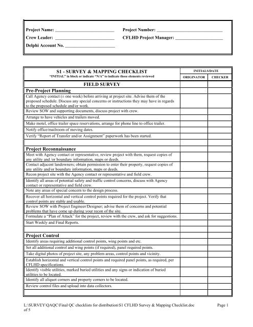
<strong>Project</strong> Name: __________________________Crew Leader: __________________________Delphi Account No. ______________________<strong>Project</strong> Number: _____________________________CFLHD <strong>Project</strong> Manager: _____________________<strong>S1</strong> - <strong>SURVEY</strong> & <strong>MAPPING</strong> <strong>CHECKLIST</strong>INITIALS/DATE“INITIAL” in block or indicate “N/A” to indicate those elements reviewed ORIGINATOR CHECKER<strong>FIELD</strong> <strong>SURVEY</strong><strong>Pre</strong>-<strong>Project</strong> PlanningCall Agency contact (± one week) before arriving at project site. Advise them of theproposed schedule. Discuss any special concerns or instructions they may have in regardsto the proposed schedule and/or work.Review SOW and supporting documents, discuss project with crew.Arrange to have vehicles and trailers moved.Make motel, office trailer space reservations, arrange for phone line to office trailer.Notify office/mailroom of moving dates.Verify “Report of Transfer and/or Assignment” paperwork has been started.<strong>Project</strong> ReconnaissanceMeet with Agency contact or representative, review project with them, request copies ofany utility and /or boundary information, maps or deeds.Contact adjacent landowners; obtain permission to enter their property, request copies ofany utility and/or boundary information, maps or deeds.Recon project site with the Agency contact or representative and field crew.Identify all areas of potential safety and traffic control concerns, discuss with Agencycontact or representative and field crew.Note any areas of special concern to the design process.Recover all horizontal and vertical control points required for the project. Verify thatcontrol points are stable and usable.Review SOW with <strong>Project</strong> Engineer/Designer; advise them of concerns and potentialproblems that have come up during your recon of the site.Formulate a “Plan of Attack” for the project, review with the crew, and ask for suggestions.Start Weekly and Final Reports.<strong>Project</strong> ControlIdentify areas requiring additional control points, wing points and etc.Set all additional control and wing points (if required), panel required points.Take digital photos of project site, any problem areas, control points and vicinity.Establish horizontal and vertical control points and required panel points, as required, perCFLHD specifications.Identify visible utilities, marked buried utilities and any signs or indication of buriedutilities to be located.Identify all aliquot corners and property corners to be located.Review control files and upload into data collectors.L:\<strong>SURVEY</strong>\QAQC\Final QC checklists for distribution\<strong>S1</strong> CFLHD Survey & Mapping Checklist.doc Page 1of 5
<strong>S1</strong> - <strong>SURVEY</strong> & <strong>MAPPING</strong> <strong>CHECKLIST</strong>INITIALS/DATE“INITIAL” in block or indicate “N/A” to indicate those elements reviewed ORIGINATOR CHECKER<strong>Project</strong> Data CollectionFill GPS Observation Log and field book.At each set-up, measure and record the HI of the instrument, HT of the prisms at thebacksight and foresight targets, and the prism on the range pole, or the GPS base stationand the rover antenna, even when using fixed height tripods and poles. Ensure thatatmospheric corrections are entered into the instrument for the elevation and conditions atthe site.Measure (and record data) to the backsight and at least one other primary control point.Verify that measurement meet CFLHD specifications.Begin collecting data as outlined by the SOW. Collect all data in a logical manner, insuringthat all required data is collected.Collect data using proper file names, feature codes, naming conventions and breaklines.Re-measure (and record data) to the backsight and at least one other primary control point.Verify that primary control points still meet CFLHD specifications.Download data files nightly, review and correct all errors.Fill out Weekly Reports.<strong>Project</strong> QA/QC Field ReviewUpon completion of a site or segment, combine the daily files, check for crossingbreaklines, create a TIN and contour lines, insert symbology and review map for errors.Combine all segments, review breaklines, re-run TIN and contour lines and review map forerrors.<strong>Project</strong> SummaryReview Weekly Reports, complete Final Report. <strong>Pre</strong>pare a tabular listing of all files and abrief description of their contents.Organize project electronic files, hardcopy field notes, maps miscellaneous notes.Complete Travel Vouchers for this project, verify that all bills, invoices and charges arepaid or arranged for payment.Transfer all required electronic files to the L:\<strong>SURVEY</strong>\STATE\PROJECT\<strong>SURVEY</strong>\THEPROPER FOLDER, Burn a backup CD or DVD and mail with hard copies to the office.PLANNING AND PREPARATION FOR AERIAL <strong>MAPPING</strong>Aerial Photo limits determinedScale of map determinedCoordinate with hydraulics &/or other sections if theyDOQQ & DRG obtained and geo-referencedFlight line (dgn) file createdhave needs in the areaFlight lines cover requested area in correct photoscaleProposed control locations shownDetermine time frame to fly aerialRequest bids from three aerial companies<strong>Pre</strong>pare Purchase Request and supporting documentsObtain check photo set and confirm compliance with aerial photography specificationsField surveyor annotates control photosL:\<strong>SURVEY</strong>\QAQC\Final QC checklists for distribution\<strong>S1</strong> CFLHD Survey & Mapping Checklist.doc Page 2of 5
<strong>S1</strong> - <strong>SURVEY</strong> & <strong>MAPPING</strong> <strong>CHECKLIST</strong>INITIALS/DATE“INITIAL” in block or indicate “N/A” to indicate those elements reviewed ORIGINATOR CHECKERObtain final control listing from surveyScan photography for soft copyObtain mapping limits from designer on photo index<strong>Pre</strong>pare and manage task order or schedule photogrammetry in-houseIf work is contracted, send pertinent materials to contractor2D Map file name:Correct naming convention usedFHWA seed file usedGlobal origin and working units correctAERIAL <strong>MAPPING</strong> FILE/SRequested area covered by final map per specificationsControl annotated per control photosSymbology correctly portrayed (line style, line weight, color, level text size) perspecificationsGrid ticks and valuesPlanimetric features and textDrainage features and textVegetation and textGeological features and textObscured area/s and textSpot elevations and textBuildings, structures, fences, signs, walls, etcControl points, Cadastral lines and text2D Contour file name:Correct naming convention usedFHWA seed file usedGlobal origin and working units correctNo out of place spikes or holes appearContour interval correct per specificationsSymbology correctly portrayed (line style, line weight, color, level text size) perspecificationsIndex contours and depressionsIndex contour lines blocked out for valuesCorrect text size and style usedIntermediate contours and depressions2D Utility file name:Correct naming convention usedFHWA seed file usedGlobal origin and working units correctRequested area covered by final utl per specificationsL:\<strong>SURVEY</strong>\QAQC\Final QC checklists for distribution\<strong>S1</strong> CFLHD Survey & Mapping Checklist.doc Page 3of 5
<strong>S1</strong> - <strong>SURVEY</strong> & <strong>MAPPING</strong> <strong>CHECKLIST</strong>INITIALS/DATE“INITIAL” in block or indicate “N/A” to indicate those elements reviewed ORIGINATOR CHECKERSymbology correctly portrayed (line style, line weight, color, level text size) perspecificationsElectrical linesGas, Oil Steam, Chemical linesCommunication, CATV linesWater linesSewer and Storm Drain linesReclaimed water, Irrigation, Slurry lines3D DTM file name:Correct naming convention usedFHWA seed file usedGlobal origin and working units correctRequested area covered by final dtm per specificationsSymbology correctly portrayed (line style, line weight, color, level text size) perspecificationsBreak linesGround shotsObscurities & VoidsFile Name/s:Proper file format usedDesired Area coveredBackground color is correctPixel size is correctORTHOPHOTO MOSAICOutline area of survey on quad sheet and send to fieldCoordinate with hydraulics &/or other sections for other needs<strong>FIELD</strong> TOPO <strong>MAPPING</strong> FILE/S2D Map and gpk file names (from field):Requested area covered inCorrect naming convention usedCorrect Pcodes usedCorrect SMD usedChain editing completePoint editing completeGeneric points and/or lines commentedRuns in gpk commentedFinal 2D Map file name:Correct naming convention usedFHWA seed file usedL:\<strong>SURVEY</strong>\QAQC\Final QC checklists for distribution\<strong>S1</strong> CFLHD Survey & Mapping Checklist.doc Page 4of 5
<strong>S1</strong> - <strong>SURVEY</strong> & <strong>MAPPING</strong> <strong>CHECKLIST</strong>INITIALS/DATE“INITIAL” in block or indicate “N/A” to indicate those elements reviewed ORIGINATOR CHECKERGlobal origin and working units correctControl annotated per control photosControl Sheet added to map fileField data added to previously mapped areas when applicableSymbology correctly portrayed (line style, line weight, color, level text size) perspecifications:Grid ticks and valuesPlanimetric features and textDrainage features and textVegetationGeological featuresObscured area/sSpot elevationsBuildings, structures, fences, signs, walls, etcControl points, Cadastral lines and textField topo area outlinedL:\<strong>SURVEY</strong>\QAQC\Final QC checklists for distribution\<strong>S1</strong> CFLHD Survey & Mapping Checklist.doc Page 5of 5


