® Ontario ontario institute of pedology - Agriculture and Agri-Food ...
® Ontario ontario institute of pedology - Agriculture and Agri-Food ... ® Ontario ontario institute of pedology - Agriculture and Agri-Food ...
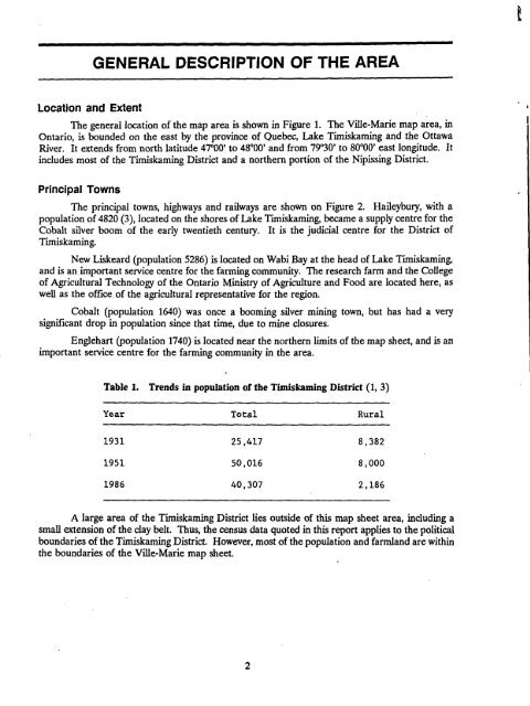
GENERAL DESCRIPTION OF THE AREALocation and ExtentThe general location of the map area is shown in Figure 1 . The Ville-Marie map area, inOntario, is bounded on the east by the province of Quebec, Lake Timiskaming and the OttawaRiver. It extends from north latitude 47°00' to 48°00' and from 79°30' to 80°00' east longitude . Itincludes most of the Timiskaming District and a northern portion of the Nipissing District .Principal TownsThe principal towns, highways and railways are shown on Figure 2 . Haileybury, with apopulation of 4820 (3), located on the shores of Lake Timiskaming, became a supply centre for theCobalt silver boom of the early twentieth century. It is the judicial centre for the District ofTimiskaming .New Liskeard (population 5286) is located on Wabi Bay at the head of Lake Timiskaming,and is an important service centre for the farming community . The research farm and the Collegeof Agricultural Technology of the Ontario Ministry of Agriculture and Food are located here, aswell as the office of the agricultural representative for the region.Cobalt (population 1640) was once a booming silver mining town, but has had a verysignificant drop in population since that time, due to mine closures .Englehart (population 1740) is located near the northern limits of the map sheet, and is animportant service centre for the farming community in the area .Table 1.YearTrends in population of theTotalTimiskaming District (1, 3)Rural1931 25,417 8,3821951 50,016 8,0001986 40,307 2,186A large area of the Timiskaming District lies outside of this map sheet area, including asmall extension of the clay belt . Thus, the census data quoted in this report applies to the politicalboundaries of the Timiskaming District. However, most of the population and farmland are withinthe boundaries of the Ville-Marie map sheet.
Figure 1 .Outline map of Ontario showing location of the Ville-Marie(Ontario section) map sheet area
- Page 1 and 2: THE SOILS OF THE VILLE-MARIE MAP SH
- Page 3 and 4: TABLE OF CONTENTSLIST OF TABLES . .
- Page 5 and 6: TABLE OF CONTENTS (continued)Soil P
- Page 7: ACKNOWLEDGEMENTSThe authors would l
- Page 11 and 12: Historical DevelopmentMr . C.C. Far
- Page 13 and 14: EARLY PRECAMBRIANMafic Metavolcanic
- Page 15 and 16: DExposed bedrock andground moraineG
- Page 17 and 18: SOIL CLASSIFICATIONThe soils descri
- Page 19 and 20: Diagrammatic horizon patterns for f
- Page 21 and 22: Table 5 .Soils mapped in the Ville-
- Page 23 and 24: 3 . Calcareous silt loam(a) Good dr
- Page 25 and 26: Coutts soilsCoutts soils are imperf
- Page 27 and 28: Kanimiwiskia soilsThe Kanimiwiskia
- Page 29 and 30: Thwaites soilsThwaites soils are we
- Page 31 and 32: Frost ProbabilitiesFor 1951-1980 11
- Page 33 and 34: CropsAdapted field crops andassocia
- Page 35 and 36: Soil Physical Properties and Tillag
- Page 37 and 38: SOIL INTERPRETATIONS FOR AGRICULTUR
- Page 39 and 40: (c) The following are not considere
- Page 41 and 42: Subclass T (Topography) RatingsIn T
- Page 43 and 44: Table 10.Universal Soil Loss Equati
- Page 45 and 46: Table 11 .Slope class descriptions
- Page 47 and 48: In Table 13, soil erosion potential
- Page 49 and 50: REFERENCES1 . Hoffman, D.W., R.E. W
- Page 51 and 52: APPENDIXChemical and Physical Analy
- Page 53 and 54: Table 16 .Chemical and physical ana
- Page 55 and 56: B .Detailed Descriptions of Typical
- Page 57 and 58: CANE SOILParent MaterialDrainage :L
GENERAL DESCRIPTION OF THE AREALocation <strong>and</strong> ExtentThe general location <strong>of</strong> the map area is shown in Figure 1 . The Ville-Marie map area, in<strong>Ontario</strong>, is bounded on the east by the province <strong>of</strong> Quebec, Lake Timiskaming <strong>and</strong> the OttawaRiver. It extends from north latitude 47°00' to 48°00' <strong>and</strong> from 79°30' to 80°00' east longitude . Itincludes most <strong>of</strong> the Timiskaming District <strong>and</strong> a northern portion <strong>of</strong> the Nipissing District .Principal TownsThe principal towns, highways <strong>and</strong> railways are shown on Figure 2 . Haileybury, with apopulation <strong>of</strong> 4820 (3), located on the shores <strong>of</strong> Lake Timiskaming, became a supply centre for theCobalt silver boom <strong>of</strong> the early twentieth century. It is the judicial centre for the District <strong>of</strong>Timiskaming .New Liskeard (population 5286) is located on Wabi Bay at the head <strong>of</strong> Lake Timiskaming,<strong>and</strong> is an important service centre for the farming community . The research farm <strong>and</strong> the College<strong>of</strong> <strong>Agri</strong>cultural Technology <strong>of</strong> the <strong>Ontario</strong> Ministry <strong>of</strong> <strong><strong>Agri</strong>culture</strong> <strong>and</strong> <strong>Food</strong> are located here, aswell as the <strong>of</strong>fice <strong>of</strong> the agricultural representative for the region.Cobalt (population 1640) was once a booming silver mining town, but has had a verysignificant drop in population since that time, due to mine closures .Englehart (population 1740) is located near the northern limits <strong>of</strong> the map sheet, <strong>and</strong> is animportant service centre for the farming community in the area .Table 1.YearTrends in population <strong>of</strong> theTotalTimiskaming District (1, 3)Rural1931 25,417 8,3821951 50,016 8,0001986 40,307 2,186A large area <strong>of</strong> the Timiskaming District lies outside <strong>of</strong> this map sheet area, including asmall extension <strong>of</strong> the clay belt . Thus, the census data quoted in this report applies to the politicalboundaries <strong>of</strong> the Timiskaming District. However, most <strong>of</strong> the population <strong>and</strong> farml<strong>and</strong> are withinthe boundaries <strong>of</strong> the Ville-Marie map sheet.


