® Ontario ontario institute of pedology - Agriculture and Agri-Food ...
® Ontario ontario institute of pedology - Agriculture and Agri-Food ... ® Ontario ontario institute of pedology - Agriculture and Agri-Food ...
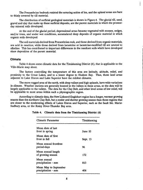
The Precambrian bedrock resisted the scouring action of ice, and the upland areas are bareto thinly covered by till material.The distribution of surficial geological materials is shown in Figure 4 . The glacial till, sand,gravel and clay that make up these surficial deposits, are the parent materials in which the presentdaymineral soils developed .At the end of the glacial period, depressional areas became vegetated with mosses, sedges,and/or trees, and under wet conditions, accumulated deep deposits of organic material in whichorganic soils developed .The soil materials derived from Precambrian rock, and those derived from organic materials,are acid in reaction ; while those derived from lacustrine or lacustrine-modified till are neutral toalkaline. This has contributed to important differences in the resultant soils which have developedsince deposition of the parent material .ClimateTable 4 shows some climatic data for the Timiskaming District (6), that is applicable to theVille-Marie map sheet .The factors controlling the temperature of this area are latitude, altitude, relief, andproximity to the Great Lakes, and to a lesser degree to Hudson Bay. Thus, those land areasadjacent to Lake Huron and Lake Superior have the mildest climates .The more rugged area of the north, with deep valleys and high uplands, have wide variationsin climate . Weather stations are generally located in the valleys in these areas, so the data will belargely applicable to the valleys . The data for the Clay Belt, and other level areas of low relief, willbe applicable to most areas within such a physiographic region .According to climatic data, the New Liskeard-Englehart region has a longer, warmer growingseason than the northern Clay Belt, but a cooler and shorter growing season than those regions thatare closer to the moderating effects of Lakes Huron and Superior, such as the Sault Ste. Marie-Sudbury area, or the Rainy River-Thunder Bay area.Table 4. Climatic data from the Timiskaming District (6)Climatic ParameterTimiskamingMean date of lastfrost in spring June 10Mean date of firstfrost in fall Sept . 13Mean annual frostfreeperiod-days 96Mean annual lengthof growing season 172Mean annualprecipitation - mm 813Mean May to Septemberprecipitation - mm 406
DExposed bedrock andground moraineGround moraine andbedrock knobsGlaciolacustrineGlaciofluvial outwashkames and eskersOrganic depositsFigure 4.Outline map showing distribution of surricial geological materials9
- Page 1 and 2: THE SOILS OF THE VILLE-MARIE MAP SH
- Page 3 and 4: TABLE OF CONTENTSLIST OF TABLES . .
- Page 5 and 6: TABLE OF CONTENTS (continued)Soil P
- Page 7 and 8: ACKNOWLEDGEMENTSThe authors would l
- Page 9 and 10: Figure 1 .Outline map of Ontario sh
- Page 11 and 12: Historical DevelopmentMr . C.C. Far
- Page 13: EARLY PRECAMBRIANMafic Metavolcanic
- Page 17 and 18: SOIL CLASSIFICATIONThe soils descri
- Page 19 and 20: Diagrammatic horizon patterns for f
- Page 21 and 22: Table 5 .Soils mapped in the Ville-
- Page 23 and 24: 3 . Calcareous silt loam(a) Good dr
- Page 25 and 26: Coutts soilsCoutts soils are imperf
- Page 27 and 28: Kanimiwiskia soilsThe Kanimiwiskia
- Page 29 and 30: Thwaites soilsThwaites soils are we
- Page 31 and 32: Frost ProbabilitiesFor 1951-1980 11
- Page 33 and 34: CropsAdapted field crops andassocia
- Page 35 and 36: Soil Physical Properties and Tillag
- Page 37 and 38: SOIL INTERPRETATIONS FOR AGRICULTUR
- Page 39 and 40: (c) The following are not considere
- Page 41 and 42: Subclass T (Topography) RatingsIn T
- Page 43 and 44: Table 10.Universal Soil Loss Equati
- Page 45 and 46: Table 11 .Slope class descriptions
- Page 47 and 48: In Table 13, soil erosion potential
- Page 49 and 50: REFERENCES1 . Hoffman, D.W., R.E. W
- Page 51 and 52: APPENDIXChemical and Physical Analy
- Page 53 and 54: Table 16 .Chemical and physical ana
- Page 55 and 56: B .Detailed Descriptions of Typical
- Page 57 and 58: CANE SOILParent MaterialDrainage :L
- Page 59 and 60: DAWSON SOILParent MaterialDrainage:
- Page 61 and 62: Bt - 33-51 cm silty clay loam; yell
- Page 63 and 64: Btg, - 23-33 cm clay; light yellowi
The Precambrian bedrock resisted the scouring action <strong>of</strong> ice, <strong>and</strong> the upl<strong>and</strong> areas are bareto thinly covered by till material.The distribution <strong>of</strong> surficial geological materials is shown in Figure 4 . The glacial till, s<strong>and</strong>,gravel <strong>and</strong> clay that make up these surficial deposits, are the parent materials in which the presentdaymineral soils developed .At the end <strong>of</strong> the glacial period, depressional areas became vegetated with mosses, sedges,<strong>and</strong>/or trees, <strong>and</strong> under wet conditions, accumulated deep deposits <strong>of</strong> organic material in whichorganic soils developed .The soil materials derived from Precambrian rock, <strong>and</strong> those derived from organic materials,are acid in reaction ; while those derived from lacustrine or lacustrine-modified till are neutral toalkaline. This has contributed to important differences in the resultant soils which have developedsince deposition <strong>of</strong> the parent material .ClimateTable 4 shows some climatic data for the Timiskaming District (6), that is applicable to theVille-Marie map sheet .The factors controlling the temperature <strong>of</strong> this area are latitude, altitude, relief, <strong>and</strong>proximity to the Great Lakes, <strong>and</strong> to a lesser degree to Hudson Bay. Thus, those l<strong>and</strong> areasadjacent to Lake Huron <strong>and</strong> Lake Superior have the mildest climates .The more rugged area <strong>of</strong> the north, with deep valleys <strong>and</strong> high upl<strong>and</strong>s, have wide variationsin climate . Weather stations are generally located in the valleys in these areas, so the data will belargely applicable to the valleys . The data for the Clay Belt, <strong>and</strong> other level areas <strong>of</strong> low relief, willbe applicable to most areas within such a physiographic region .According to climatic data, the New Liskeard-Englehart region has a longer, warmer growingseason than the northern Clay Belt, but a cooler <strong>and</strong> shorter growing season than those regions thatare closer to the moderating effects <strong>of</strong> Lakes Huron <strong>and</strong> Superior, such as the Sault Ste. Marie-Sudbury area, or the Rainy River-Thunder Bay area.Table 4. Climatic data from the Timiskaming District (6)Climatic ParameterTimiskamingMean date <strong>of</strong> lastfrost in spring June 10Mean date <strong>of</strong> firstfrost in fall Sept . 13Mean annual frostfreeperiod-days 96Mean annual length<strong>of</strong> growing season 172Mean annualprecipitation - mm 813Mean May to Septemberprecipitation - mm 406


