® Ontario ontario institute of pedology - Agriculture and Agri-Food ...
® Ontario ontario institute of pedology - Agriculture and Agri-Food ... ® Ontario ontario institute of pedology - Agriculture and Agri-Food ...
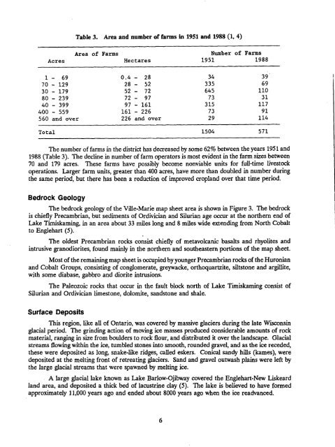
Table 3.Area and number of farmsin 1951 and 1988 (1, 4)AcresArea ofFarmsHectaresNumber of1951Farms19881 - 69 0 .4 - 28 34 3970 - 129 28 - 52 335 6930 - 179 52 - 72 645 11080 - 239 72 - 97 73 3140 - 399 97 - 161 315 117400 - 559 161 - 226 73 91560 and over 226 and over 29 114Total 1504 571The number of farms in the district has decreased by some 62% between the years 1951 and1988 (Table 3). The decline in number of farm operators is most evident in the farm sizes between70 and 179 acres. These farms have possibly become nonviable units for full-time livestockoperations . Larger farm units, greater than 400 acres, have more than doubled in number duringthe same period, but there has been a reduction of improved cropland over that time period .Bedrock GeologyThe bedrock geology of the Ville-Marie map sheet area is shown in Figure 3 . The bedrockis chiefly Precambrian, but sediments of Ordivician and Silurian age occur at the northern end ofLake Timiskaming, in an area about 33 miles long and 8 miles wide extending from North Cobaltto Englehart (5) .The oldest Precambrian rocks consist chiefly of metavolcanic basalts and rhyolites andintrusive granodiorites, found mainly in the northern and southeastern portions of the map sheet .Most of the remaining map sheet is occupied by younger Precambrian rocks of the Huronianand Cobalt Groups, consisting of conglomerate, greywacke, orthoquartzite, siltstone and argillite,with some diabase, gabbro and diorite intrusions .The Paleozoic rocks that occur in the fault block north of Lake Timiskaming consist ofSilurian and Ordivician limestone, dolomite, sandstone and shale.Surface DepositsThis region, like all of Ontario, was covered by massive glaciers during the late Wisconsinglacial period . The grinding action of moving ice masses produced considerable amounts of rockmaterial, ranging in size from boulders to rock flour, and distributed it over the landscape. Glacialstreams flowing within the ice, tumbled stones into smooth, rounded gravel, and as the ice receded,these were deposited as long, snake-like ridges, called eskers . Conical sandy hills (kames), weredeposited at the melting front of retreating glaciers . Sand and gravel outwash plains were left bythe large glacial streams that were spawned by melting ice .A large glacial lake known as Lake Barlow-Ojibway covered the Englehart-New Liskeardland area, and deposited a thick bed of lacustrine clay (5) . The lake is believed to have formedapproximately 11,000 years ago and ended about 8000 years ago when the ice readvanced .
EARLY PRECAMBRIANMafic Metavolcanicbasalt, andesiteFelsic to Intermediate Metavolcanics- rhyolite, rhyodaciteFelsic Intrusivegranodiorite, trondhjemiteMIDDLE PRECAMBRIANHuronian, Cobalt Groupconglomerate, greywacke, orthoquartzite, siltstone, argillite000000 00 acâ ° I,- .-ILate Mafic Igneous Rocksdiabase, gabbro, dioritePALEOZOICSilurian, Ordovicianlimestone, dolomitesandstones, shalesFigure 3 .Outline map showing the bedrock geology
- Page 1 and 2: THE SOILS OF THE VILLE-MARIE MAP SH
- Page 3 and 4: TABLE OF CONTENTSLIST OF TABLES . .
- Page 5 and 6: TABLE OF CONTENTS (continued)Soil P
- Page 7 and 8: ACKNOWLEDGEMENTSThe authors would l
- Page 9 and 10: Figure 1 .Outline map of Ontario sh
- Page 11: Historical DevelopmentMr . C.C. Far
- Page 15 and 16: DExposed bedrock andground moraineG
- Page 17 and 18: SOIL CLASSIFICATIONThe soils descri
- Page 19 and 20: Diagrammatic horizon patterns for f
- Page 21 and 22: Table 5 .Soils mapped in the Ville-
- Page 23 and 24: 3 . Calcareous silt loam(a) Good dr
- Page 25 and 26: Coutts soilsCoutts soils are imperf
- Page 27 and 28: Kanimiwiskia soilsThe Kanimiwiskia
- Page 29 and 30: Thwaites soilsThwaites soils are we
- Page 31 and 32: Frost ProbabilitiesFor 1951-1980 11
- Page 33 and 34: CropsAdapted field crops andassocia
- Page 35 and 36: Soil Physical Properties and Tillag
- Page 37 and 38: SOIL INTERPRETATIONS FOR AGRICULTUR
- Page 39 and 40: (c) The following are not considere
- Page 41 and 42: Subclass T (Topography) RatingsIn T
- Page 43 and 44: Table 10.Universal Soil Loss Equati
- Page 45 and 46: Table 11 .Slope class descriptions
- Page 47 and 48: In Table 13, soil erosion potential
- Page 49 and 50: REFERENCES1 . Hoffman, D.W., R.E. W
- Page 51 and 52: APPENDIXChemical and Physical Analy
- Page 53 and 54: Table 16 .Chemical and physical ana
- Page 55 and 56: B .Detailed Descriptions of Typical
- Page 57 and 58: CANE SOILParent MaterialDrainage :L
- Page 59 and 60: DAWSON SOILParent MaterialDrainage:
- Page 61 and 62: Bt - 33-51 cm silty clay loam; yell
Table 3.Area <strong>and</strong> number <strong>of</strong> farmsin 1951 <strong>and</strong> 1988 (1, 4)AcresArea <strong>of</strong>FarmsHectaresNumber <strong>of</strong>1951Farms19881 - 69 0 .4 - 28 34 3970 - 129 28 - 52 335 6930 - 179 52 - 72 645 11080 - 239 72 - 97 73 3140 - 399 97 - 161 315 117400 - 559 161 - 226 73 91560 <strong>and</strong> over 226 <strong>and</strong> over 29 114Total 1504 571The number <strong>of</strong> farms in the district has decreased by some 62% between the years 1951 <strong>and</strong>1988 (Table 3). The decline in number <strong>of</strong> farm operators is most evident in the farm sizes between70 <strong>and</strong> 179 acres. These farms have possibly become nonviable units for full-time livestockoperations . Larger farm units, greater than 400 acres, have more than doubled in number duringthe same period, but there has been a reduction <strong>of</strong> improved cropl<strong>and</strong> over that time period .Bedrock GeologyThe bedrock geology <strong>of</strong> the Ville-Marie map sheet area is shown in Figure 3 . The bedrockis chiefly Precambrian, but sediments <strong>of</strong> Ordivician <strong>and</strong> Silurian age occur at the northern end <strong>of</strong>Lake Timiskaming, in an area about 33 miles long <strong>and</strong> 8 miles wide extending from North Cobaltto Englehart (5) .The oldest Precambrian rocks consist chiefly <strong>of</strong> metavolcanic basalts <strong>and</strong> rhyolites <strong>and</strong>intrusive granodiorites, found mainly in the northern <strong>and</strong> southeastern portions <strong>of</strong> the map sheet .Most <strong>of</strong> the remaining map sheet is occupied by younger Precambrian rocks <strong>of</strong> the Huronian<strong>and</strong> Cobalt Groups, consisting <strong>of</strong> conglomerate, greywacke, orthoquartzite, siltstone <strong>and</strong> argillite,with some diabase, gabbro <strong>and</strong> diorite intrusions .The Paleozoic rocks that occur in the fault block north <strong>of</strong> Lake Timiskaming consist <strong>of</strong>Silurian <strong>and</strong> Ordivician limestone, dolomite, s<strong>and</strong>stone <strong>and</strong> shale.Surface DepositsThis region, like all <strong>of</strong> <strong>Ontario</strong>, was covered by massive glaciers during the late Wisconsinglacial period . The grinding action <strong>of</strong> moving ice masses produced considerable amounts <strong>of</strong> rockmaterial, ranging in size from boulders to rock flour, <strong>and</strong> distributed it over the l<strong>and</strong>scape. Glacialstreams flowing within the ice, tumbled stones into smooth, rounded gravel, <strong>and</strong> as the ice receded,these were deposited as long, snake-like ridges, called eskers . Conical s<strong>and</strong>y hills (kames), weredeposited at the melting front <strong>of</strong> retreating glaciers . S<strong>and</strong> <strong>and</strong> gravel outwash plains were left bythe large glacial streams that were spawned by melting ice .A large glacial lake known as Lake Barlow-Ojibway covered the Englehart-New Liskeardl<strong>and</strong> area, <strong>and</strong> deposited a thick bed <strong>of</strong> lacustrine clay (5) . The lake is believed to have formedapproximately 11,000 years ago <strong>and</strong> ended about 8000 years ago when the ice readvanced .


