Engineering monitoring of rockfall hazards along transportation ...
Engineering monitoring of rockfall hazards along transportation ...
Engineering monitoring of rockfall hazards along transportation ...

Create successful ePaper yourself
Turn your PDF publications into a flip-book with our unique Google optimized e-Paper software.
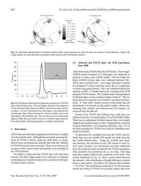
942 M. Lato et al.: Using mobile terrestrial LiDAR for <strong>rockfall</strong> hazard analysisFig. 11. Kinematic identification <strong>of</strong> possible <strong>rockfall</strong> failure modes present near mile 94 <strong>along</strong> the Algoma Central Railway. Topple andwedge failures are both identified as possible modes based on the LiDAR data analysis.4.1 Airborne and TITAN data: the ACR experiment,June 2008Fig. 12. Histogram illustrating the alignment comparison <strong>of</strong> TITANdata with helicopter data. The inset figure illustrates the alignment<strong>of</strong> the helicopter data (shown in black) with the titan data (shownin white). As well, illustrated in the inset figure is the general lack<strong>of</strong> helicopter data collected <strong>along</strong> the vertical rockface, due to thelook-angle <strong>of</strong> the airborne laser. The two data sets are not manuallyaligned, rather they are simply viewed in a common space based ontheir individually collected geographic coordinate information.4 Data fusionTITAN data provides data ranging from track level to roughly30 m beyond the track. Although the maximum scanning distance<strong>of</strong> TITAN is 200 m, <strong>along</strong> the ACR there is a denseBoreal forest and numerous outcrops that limit the visibility<strong>of</strong> TITAN from the track outwards. There were however noinstances where known track-side <strong>hazards</strong> were occluded inthe TITAN dataset.The ability to align and fuse TITAN data with other datasources will allow larger areas to be collected via airbornemethodologies or detailed studies to be completed with highresolutionstatic systems.Aside from using TITAN <strong>along</strong> the ACR track, a “low-range”LiDAR system mounted on a helicopter was deployed togenerate a valley scale LiDAR model. The low-range airborneLiDAR systems data were collected between 200–300 m above ground level. Low-range helicopter systemsare designed to collect relatively dense data in comparisonto fixed-wing aerial systems. This was completed during thesummer <strong>of</strong> 2007, 12 months before the scanning <strong>of</strong> the ACRusing the TITAN system. The resultant point-cloud producedby the helicopter system contains roughly 10 pts/m 2 . The airbornedata were reported in two formats: un-edited and bareearth.A “bare earth” model consists <strong>of</strong> the points that aredetermined to lie directly on the earth’s surface. Points representingtrees, shrubs, and infrastructure, for example, areremoved from the data set.Fusion <strong>of</strong> the TITAN and Airborne bare earth data wasachieved with the 3-D functionality <strong>of</strong> ArcGIS (ESRI, 2008).There was no adjustment <strong>of</strong> either dataset; they were simplyaligned and merged based on their independently collectedlocation information. For computing efficiency, only 1/12 <strong>of</strong>the data generated by TITAN were used for modelling completedin ArcGIS.To determine the correlation between the TITAN and airbornedata sets, an ArcGIS TIN model was built from thebare earth airborne data. Using the ArcGIS spot elevationfunction, the elevation on this TIN model at each TI-TAN point location was determined and then subtractedfrom the actual elevation recorded by the TITAN equipment.This operation was performed for a 1 m wide, 1 km longstrip that roughly followed the centerline <strong>of</strong> the track. Theresults, illustrated by Fig. 12, show a good match betweenthe datasets, with a distribution <strong>of</strong> height differences centredabout a point about 1 cm below the airborne data (median=−0.133 m). The small bump around the 0.3 m division representsthe ability <strong>of</strong> TITAN to accurately collect data fromNat. Hazards Earth Syst. Sci., 9, 935–946, 2009www.nat-<strong>hazards</strong>-earth-syst-sci.net/9/935/2009/