Housing Needs Assessment 2006 - Westminster City Council
Housing Needs Assessment 2006 - Westminster City Council
Housing Needs Assessment 2006 - Westminster City Council
- No tags were found...

Create successful ePaper yourself
Turn your PDF publications into a flip-book with our unique Google optimized e-Paper software.
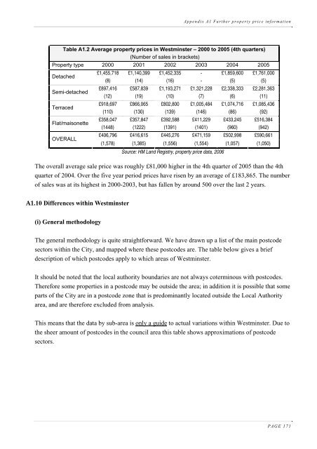
Appendix A1 Further property price informationTable A1.2 Average property prices in <strong>Westminster</strong> – 2000 to 2005 (4th quarters)(Number of sales in brackets)Property type 2000 2001 2002 2003 2004 2005DetachedSemi-detachedTerracedFlat/maisonetteOVERALL£1,455,718 £1,140,399 £1,452,335 - £1,859,600 £1,761,000(8) (14) (16) - (5) (5)£897,416 £587,839 £1,193,271 £1,321,228 £2,338,333 £2,281,363(12) (19) (10) (7) (6) (11)£918,697 £866,065 £802,800 £1,005,484 £1,074,716 £1,085,436(110) (130) (139) (146) (86) (92)£358,047 £357,847 £392,588 £411,229 £433,245 £516,384(1448) (1222) (1391) (1401) (960) (942)£406,796 £416,615 £445,276 £471,159 £502,998 £590,661(1,578) (1,385) (1,556) (1,554) (1,057) (1,050)Source: HM Land Registry, property price data, <strong>2006</strong>The overall average sale price was roughly £81,000 higher in the 4th quarter of 2005 than the 4thquarter of 2004. Over the five year period prices have risen by an average of £183,865. The numberof sales was at its highest in 2000-2003, but has fallen by around 500 over the last 2 years.A1.10 Differences within <strong>Westminster</strong>(i) General methodologyThe general methodology is quite straightforward. We have drawn up a list of the main postcodesectors within the <strong>City</strong>, and mapped where these postcodes are. The table below gives a briefdescription of which postcodes apply to which areas of <strong>Westminster</strong>.It should be noted that the local authority boundaries are not always coterminous with postcodes.Therefore some properties in a postcode may be outside the area; in addition it is possible that someparts of the <strong>City</strong> are in a postcode zone that is predominantly located outside the Local Authorityarea, and are therefore excluded from analysis.This means that the data by sub-area is only a guide to actual variations within <strong>Westminster</strong>. Due tothe sheer amount of postcodes in the council area this table shows approximations of postcodesectors.PAGE 171