Manly Lagoon Dredging Project - Manly Council - NSW Government
Manly Lagoon Dredging Project - Manly Council - NSW Government
Manly Lagoon Dredging Project - Manly Council - NSW Government
- No tags were found...

You also want an ePaper? Increase the reach of your titles
YUMPU automatically turns print PDFs into web optimized ePapers that Google loves.
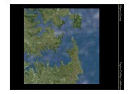
<strong>Manly</strong> <strong>Lagoon</strong> <strong>Dredging</strong> <strong>Project</strong> – Review of Environmental FactorsPrepared for <strong>Manly</strong> and Warringah <strong>Council</strong>sreinforced concrete box culvert 3.3m wide by 1.8m high by 50m length, terminating justbeyond the seaward end of the Queenscliff Rock Pool. The low flow pipes have remainedunblocked since completion of the extension works and now allow lagoon and ocean waterexchange during each tidal cycle without interruption.2.3 Objectives of the Proposed WorksThe proposed dredging of <strong>Manly</strong> <strong>Lagoon</strong> has the following objectives which will provide bothsocio-economic and environmental benefits: Improve water quality in the <strong>Lagoon</strong> through increased tidal circulation, mixing andexchange; Improve amenity value of <strong>Manly</strong> <strong>Lagoon</strong>; Maintain an open water channel within <strong>Manly</strong> <strong>Lagoon</strong>; Progress rehabilitation of <strong>Manly</strong> <strong>Lagoon</strong> in accordance with ongoing management ofthe <strong>Manly</strong> <strong>Lagoon</strong> Estuary; Achieve a net reduction in the mass of pollutants within the lagoon.2.4 Description of the Existing Environment<strong>Manly</strong> <strong>Lagoon</strong> defines the boundary between the <strong>Manly</strong> LGA in the south and the WarringahLGA in the north. The majority of the lagoon foreshore is public and private open space.Open space on the foreshore within the <strong>Manly</strong> LGA, as shown on Figure 1.2, includes: <strong>Lagoon</strong> Park; Keirle Park (<strong>Council</strong> owned and Crown land); and <strong>Manly</strong> Golf Course (Private open space).Open space on the foreshore within the Warringah LGA, as shown on Figure 1.2, includes: Aitken Reserve; Hinkler Park (Crown land under management of <strong>Council</strong>); Nolan Reserve (Mostly <strong>Council</strong> owned); Passmore Reserve (Mostly <strong>Council</strong> owned); and Warringah Golf Course (Mostly <strong>Council</strong> owned, privately managed public openspace).District Park comprises Warringah Golf Course, and Nolan and Passmore Reservesadjacent to the lagoon. It also includes Miller and David Thomas Reserves which are locatedoutside the study area, west of Condamine Street, as shown on Figure 1.2. <strong>Manly</strong> Creekand Brookvale Creek flow through District Park.Land on the bed of <strong>Manly</strong> <strong>Lagoon</strong> is Crown land, managed under the Crown Lands Act1989, and hence is under the control of LPMA (formerly DoL).Historically, a great deal of land-filling and reclamation of wetlands around the <strong>Lagoon</strong> hastaken place. <strong>Manly</strong> Golf Course, <strong>Lagoon</strong> Park, Hinkler Park, Warringah Golf Course, NolanReserve and Keirle Park are all areas that were historically reclaimed and filled, mostly with2 July 2010 Cardno (<strong>NSW</strong>/ACT) Pty Ltd 8H:\Doc\2010\Reports.2010\Rep2580v4.doc