

Mapping to Proposed Zoning By-Law - Town of Innisfil
Mapping to Proposed Zoning By-Law - Town of Innisfil
Mapping to Proposed Zoning By-Law - Town of Innisfil

You also want an ePaper? Increase the reach of your titles
YUMPU automatically turns print PDFs into web optimized ePapers that Google loves.
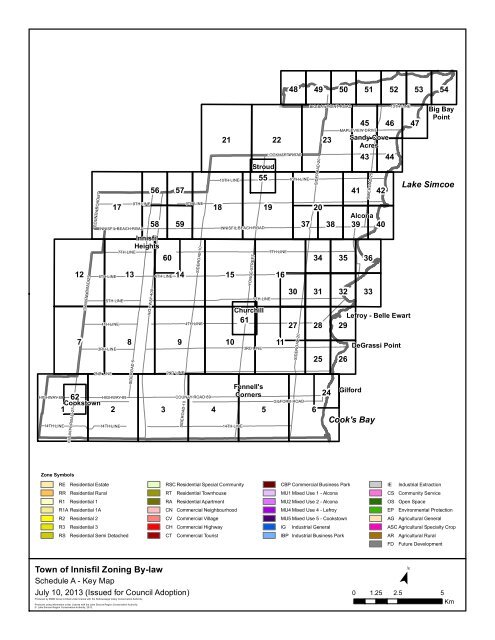
4849505152535412COUNTY ROAD 27COUNTY ROAD 276TH LINE175TH LINE4TH LINE9TH LINEINNISFIL BEACH ROAD56 5758 59<strong>Innisfil</strong>Heights6013147TH LINEHIGHWAY 4006TH LINE9TH LINESIDEROAD 104TH LINE2110TH LINE18 1915YONGE STREETStroud55INNISFIL BEACH ROAD5TH LINEChurchill6122LOCKHART ROAD7TH LINE1610TH LINE302737BIG BAY POINT ROADSIDEROAD 2020343128233835324145MAPLEVIEW DRIVESandy CoveAcres43SIDEROAD 25Alcona39 40363342464413TH LINELefroy - Belle Ewart2947Big BayPointLake SimcoeHIGHWAY 8914TH LINE7862Cooks<strong>to</strong>wn1COUNTY ROAD 273RD LINE2ND LINEHIGHWAY 89214TH LINESIDEROAD 5392ND LINECOUNTY ROAD 89SIDEROAD 10103RD LINE11GILFORD ROAD4 5614TH LINEFennell'sCornersSIDEROAD 20252426GilfordCook's BayDeGrassi PointZone SymbolsREResidential EstateRSC Residential Special CommunityCBP Commercial Business ParkIEIndustrial ExtractionRRResidential RuralRTResidential <strong>Town</strong>houseMU1 Mixed Use 1 - AlconaCSCommunity ServiceR1 Residential 1RAResidential ApartmentMU2 Mixed Use 2 - AlconaOSOpen SpaceR1A Residential 1ACNCommercial NeighbourhoodMU4 Mixed Use 4 - LefroyEPEnvironmental ProtectionR2 Residential 2CVCommercial VillageMU5 Mixed Use 5 - Cooks<strong>to</strong>wnAGAgricultural GeneralR3 Residential 3CHCommercial HighwayIGIndustrial GeneralASC Agricultural Specialty CropRSResidential Semi DetachedCTCommercial TouristIBP Industrial Business ParkARAgricultural RuralFDFuture Development<strong>Town</strong> <strong>of</strong> <strong>Innisfil</strong> <strong>Zoning</strong> <strong>By</strong>-lawSchedule A - Key MapJuly 10, 2013 (Issued for Council Adoption) 0 1.25 2.5 5Produced by MMM Group Limited under license with the Nottawasaga Valley Conservation Authority.Produced using information under License with the Lake Simcoe Region Conservation Authority© Lake Simcoe Region Conservation Authority, 2012.¯Km
NEILLY ROADEVERTON DRIVER1R1-WREOS-525/26AGDEMPSEY STREETR1R1R1OSERL PLACER1-WR1-WOSR1PARKVIEW DRIVEOSR1BAYSHORE ROADOSEPR1-WR1NORTH SHORE DRIVEGOLFVIEW DRIVER1R1VERNOR DRIVER1-WCSR1R1PARKWAY DRIVELAKESHORE BOULEVARDEP6OSOSOSMARINE DRIVER1R1-WR1R1GLEN KERR DRIVEOSR1CTSHORE ACRES DRIVEAGR1EP-13RE-6(H)R1LINDY LANER1POPLAR DRIVEBEACH ROADR1-WR1RE-6(H)R1R1-WGILFORD ROADR1AGR1CTCT-4CTNESBITT ROADR1R1BEACH ROADR1-WBIRCH ROADEP<strong>Town</strong> <strong>of</strong> <strong>Innisfil</strong> <strong>Zoning</strong> <strong>By</strong>-lawSchedule A - Map 24July 10, 2013(Issued for Council Adoption)Produced by MMM Group Limited under license with the Nottawasaga Valley Conservation Authority.Produced using information under License with the Lake Simcoe Region Conservation Authority© Lake Simcoe Region Conservation Authority, 2012.LegendHazard Lands (Regulated Area)(Section 3.19)! ! !Intake Protection Zone (Section 3.51)Wellhead Protection Area A(Section 3.51)Wellhead Protection Area B(Section 3.51)! ! !!! !6Primary Visual Impact Area(Section 3.32)Waste Disposal Site (Section 3.47)Waste Disposal Assessment Area(Section 3.47)W - W Waterfront Lots (Section 3.49)W W¯0 100 200Meters
RRR1R1-WR1-W28AGEPCTAGRAILIEEPEPOSPINE AVENUEAGHARBOUR STREETOS-8(H)EPOS-8(H)RRIE3RD LINEAGOS-7AGEP11EP26AGR1R1CT-6R1R1-WAG2ND LINELIMERICK STREETAG-19<strong>Town</strong> <strong>of</strong> <strong>Innisfil</strong> <strong>Zoning</strong> <strong>By</strong>-lawSchedule A - Map 25July 10, 2013(Issued for Council Adoption)Produced by MMM Group Limited under license with the Nottawasaga Valley Conservation Authority.Produced using information under License with the Lake Simcoe Region Conservation Authority© Lake Simcoe Region Conservation Authority, 2012.RROSRELegendHazard Lands (Regulated Area)(Section 3.19)! ! !Intake Protection Zone (Section 3.51)Wellhead Protection Area A(Section 3.51)Wellhead Protection Area B(Section 3.51)! ! !!! !6/24OS-5Primary Visual Impact Area(Section 3.32)Waste Disposal Site (Section 3.47)Waste Disposal Assessment Area(Section 3.47)W - W Waterfront Lots (Section 3.49)W WRRR1R1AGOSR1¯DEMPSEY STREET0 100 200MetersR1-W
R129CTOS-8(H)EPDEGRASSI COVE PLACEOS-8(H) 3RD LINEMCMURRICH PLACER1R1-WR1INNISFREE PLACEEPR1-W25R1R1R1-WR1R1CT-6R1-WLIMERICK STREETAGR1-W2ND LINEAGDEMPSEY STREETR1R1PARK PLACER1OSR1-WR1-W<strong>Town</strong> <strong>of</strong> <strong>Innisfil</strong> <strong>Zoning</strong> <strong>By</strong>-lawSchedule A - Map 26July 10, 2013(Issued for Council Adoption)Produced by MMM Group Limited under license with the Nottawasaga Valley Conservation Authority.Produced using information under License with the Lake Simcoe Region Conservation Authority© Lake Simcoe Region Conservation Authority, 2012.LegendHazard Lands (Regulated Area)(Section 3.19)! ! !Intake Protection Zone (Section 3.51)Wellhead Protection Area A(Section 3.51)Wellhead Protection Area B(Section 3.51)! ! !!! !24Primary Visual Impact Area(Section 3.32)Waste Disposal Site (Section 3.47)Waste Disposal Assessment Area(Section 3.47)W - W Waterfront Lots (Section 3.49)W W¯0 100 200Meters
FD30R2-6(H)R1-26(H)RT-11(H)R2-6(H)R2-5(H)AGRROSEPSIDEROAD 20OSR1-26(H)EPAGR1-26(H)EPOSCSAGRRRRCN-12(H)11RRRRKILLARNEY BEACH ROADRRCSCS-6(H)CN-12(H)OSFD EPR1R1CS28CSRT-12(H)RT-11(H)EPOSFDR1OSEPEPR2-6(H)RT-11(H)R2-6(H)OSR2-6(H)R1-28(H)R1R2-6(H)RT-11(H)OSEPR2-6(H)R2-5(H)R1-27(H)AGR1-26(H)RT-11(H)R2-5(H)OSR1-27(H)AGRAIL<strong>Town</strong> <strong>of</strong> <strong>Innisfil</strong> <strong>Zoning</strong> <strong>By</strong>-lawSchedule A - Map 27July 10, 2013(Issued for Council Adoption)Produced by MMM Group Limited under license with the Nottawasaga Valley Conservation Authority.Produced using information under License with the Lake Simcoe Region Conservation Authority© Lake Simcoe Region Conservation Authority, 2012.LegendHazard Lands (Regulated Area)(Section 3.19)! ! !Intake Protection Zone (Section 3.51)Wellhead Protection Area A(Section 3.51)Wellhead Protection Area B(Section 3.51)! ! !!! !11Primary Visual Impact Area(Section 3.32)Waste Disposal Site (Section 3.47)Waste Disposal Assessment Area(Section 3.47)W - W Waterfront Lots (Section 3.49)W W¯0 100 200MetersAG
FDR1MU431OSR2-5(H)RT-11(H)R1FDR1EPOSR1-26(H)R2-5(H)R1-26(H)EPR1-26(H)OSOSR1-26(H)R1OSR1RAILAGCORNER AVENUEFDAGR1R1WALTER STREETGILMORE AVENUEEPR1R1CARSON AVENUEEP EPR1-7FERRIER AVENUER1AGEPAGR1EWART STREETEPAG-16R1FDR1AGAGR1R1CAMERON STREETWEST LANECUMBERLAND STREETCT-5R1R1R1FDR1CN-10R1EMILY STREETR127CN-12(H)EPFD EPR1CSR1ARDILL STREETCSMU4CSMU4MU4R1MU4-1FRONT STREETFDMU4CSR1R1 R1R1MU4R1KILLARNEY BEACH ROADLORNE AVENUER1MU4R1CHR1CNR1CN-5R1R1CSR1(H)R1EPR1(H)R1AG-16AGR1R1R1ELIZABETH AVENUER1CTBARRY AVENUER1-WR1-W29OSFDR1CHURCH DRIVER1RR-2AGR1PINE AVENUEAGHARBOUR STREETR1-WR1-28(H)R1AGR2-5(H)R1-WOSEPR1-27(H)EPBEACHCOMBER PLACER1-26(H)OSR1-27(H)IEAGCTEPAGRAILEPEPIEAGEPEP<strong>Town</strong> <strong>of</strong> <strong>Innisfil</strong> <strong>Zoning</strong> <strong>By</strong>-lawSchedule A - Map 28July 10, 2013(Issued for Council Adoption)Produced by MMM Group Limited under license with the Nottawasaga Valley Conservation Authority.Produced using information under License with the Lake Simcoe Region Conservation Authority© Lake Simcoe Region Conservation Authority, 2012.LegendHazard Lands (Regulated Area)(Section 3.19)! ! !Intake Protection Zone (Section 3.51)Wellhead Protection Area A(Section 3.51)Wellhead Protection Area B(Section 3.51)! ! !!! !25AGOS-8(H)Primary Visual Impact Area(Section 3.32)Waste Disposal Site (Section 3.47)Waste Disposal Assessment Area(Section 3.47)W - W Waterfront Lots (Section 3.49)W W¯EP0 100 200Meters
AGR1R1R1EPFDR1R1R1CAMERON STREETWEST LANER1R1CN-10R1R1R1R1EMILY STREETEWART STREETR1R1CN-14R1EVANS PLACEISABELLA STREETR1OSCSR1-14R1-WR1R1R1-WCSR1ARNOLD STREETOSGOLDIE STREETCSR1-WR1SHEPPARDS TRAILR132R1OSR1R1-WR1AGR1ALFRED STREETR1-WR1CTFDR1-WCUMBERLAND STREETAG-16EPCT-5AGR1R1R1-10EPEP EPWISKER AVENUEEPAGAGR1R1BARRY AVENUER1-W28CTR1R1-WR1AGR1-WR1-WDEGRASSI COVE PLACECTR1-W<strong>Town</strong> <strong>of</strong> <strong>Innisfil</strong> <strong>Zoning</strong> <strong>By</strong>-lawSchedule A - Map 29July 10, 2013(Issued for Council Adoption)Produced by MMM Group Limited under license with the Nottawasaga Valley Conservation Authority.Produced using information under License with the Lake Simcoe Region Conservation Authority© Lake Simcoe Region Conservation Authority, 2012.EPLegendHazard Lands (Regulated Area)(Section 3.19)! ! !Intake Protection Zone (Section 3.51)Wellhead Protection Area A(Section 3.51)Wellhead Protection Area B(Section 3.51)! ! !!! !26Primary Visual Impact Area(Section 3.32)Waste Disposal Site (Section 3.47)Waste Disposal Assessment Area(Section 3.47)W - W Waterfront Lots (Section 3.49)W W¯0 100 200Meters
RR-716AGEPAGRR-6AG6TH LINERRAGEPAGEPEPAG16AG31SIDEROAD 20EPAG5TH LINEBELLE AIRE BEACH ROADCSRT-11(H)RT-11(H)R2-6(H)R2-5(H)EP<strong>Town</strong> <strong>of</strong> <strong>Innisfil</strong> <strong>Zoning</strong> <strong>By</strong>-lawSchedule A - Map 30July 10, 2013(Issued for Council Adoption)Produced by MMM Group Limited under license with the Nottawasaga Valley Conservation Authority.Produced using information under License with the Lake Simcoe Region Conservation Authority© Lake Simcoe Region Conservation Authority, 2012.AGLegendHazard Lands (Regulated Area)(Section 3.19)! ! !Intake Protection Zone (Section 3.51)Wellhead Protection Area A(Section 3.51)Wellhead Protection Area B(Section 3.51)! ! !!! !27Primary Visual Impact Area(Section 3.32)Waste Disposal Site (Section 3.47)Waste Disposal Assessment Area(Section 3.47)W - W Waterfront Lots (Section 3.49)W WR2-6(H)RT-11(H)R2-6(H)OSCS-6(H)RT-11(H)R2-6(H)¯R2-6(H)R2-5(H)R2-5(H)RT-11(H)0 100 200MetersR1-26(H)
CS34AGAGRAILAGEP6TH LINERRRRAGSIDEROAD 20AGAGEPRAILEPAG30AG32AGAGRRRRBELLE AIRE BEACH ROADRT-11(H)CN-11(H)R2-6(H)RT-11(H)AGARNOLD STREETR1R1R2-6(H)R2-6(H)AGR1EPR2-6(H)R2-6(H)R2-6(H)R2-5(H)R2-5(H)RT-11(H)R2-6(H)OSR1-26(H)R2-5(H)RT-11(H)R2-6(H)<strong>Town</strong> <strong>of</strong> <strong>Innisfil</strong> <strong>Zoning</strong> <strong>By</strong>-lawSchedule A - Map 31July 10, 2013(Issued for Council Adoption)Produced by MMM Group Limited under license with the Nottawasaga Valley Conservation Authority.Produced using information under License with the Lake Simcoe Region Conservation Authority© Lake Simcoe Region Conservation Authority, 2012.RT-11(H)RT-11(H)OSR1RAILCORNER AVENUER1R1SQUIRE STREETLegendHazard Lands (Regulated Area)(Section 3.19)! ! !Intake Protection Zone (Section 3.51)Wellhead Protection Area A(Section 3.51)Wellhead Protection Area B(Section 3.51)! ! !!! !28AGR1 AGEPPrimary Visual Impact Area(Section 3.32)Waste Disposal Site (Section 3.47)Waste Disposal Assessment Area(Section 3.47)W - W Waterfront Lots (Section 3.49)W W¯0 100 200MetersR1R1
MAPLE ROADAGEP35CS6TH LINEAGRRAGAGEPOSEPR1-WMAPLE WAYR1R1-WR1-WAGOSOSLARCH STREET31REID AVENUER1FERN ROADR1R1R1-W33TEMPLE AVENUEELM ROADR1R1R1SPOONERS ROADR1CN-2SPRUCE ROADEPAGAGR1R1BALSAM ROADRRR1R1-WR1BELLE AIRE BEACH ROADR1ARNOLD STREETEPR1WILLOW STREETR1EPR1 R1EPR1R1EPR1EPR1CN-14<strong>Town</strong> <strong>of</strong> <strong>Innisfil</strong> <strong>Zoning</strong> <strong>By</strong>-lawSchedule A - Map 32July 10, 2013(Issued for Council Adoption)Produced by MMM Group Limited under license with the Nottawasaga Valley Conservation Authority.Produced using information under License with the Lake Simcoe Region Conservation Authority© Lake Simcoe Region Conservation Authority, 2012.R1CSEPEPR1R1CSCSOSEPR1CSR1R1EPEWART STREETEPR1GOLDIE STREETR1CHAPMAN STREETR1R1R1AGLegendHazard Lands (Regulated Area)(Section 3.19)! ! !Intake Protection Zone (Section 3.51)Wellhead Protection Area A(Section 3.51)Wellhead Protection Area B(Section 3.51)! ! !!! !29R1R1OSR1-WRA-2EPR1OSR1AGCLAVER AVENUEAGR1FREDERICK STREETR1-WR1OSR1R1MARTHA STREETALFRED STREETR1-WR1-WPrimary Visual Impact Area(Section 3.32)Waste Disposal Site (Section 3.47)Waste Disposal Assessment Area(Section 3.47)W - W Waterfront Lots (Section 3.49)W WR1R1-WLITTLE CEDAR AVENUE¯0 100 200Meters
R2MILL STREETR237/38EPAGAGEPRTCERESINO CRESCENTRTR2R3(H)R2RT-1R2R2R2R2ROMINA COURTR2R2-2OSR2R2R2WILSON STREETR2R2FDRS-4R2RS-4EMERALD COURTR2PRINCE COURTR2OSR2EPOS-1R2OSR2-3OS(H)R2-3AGRRAGRAILFOREST STREETEPRTRS-2RS-3R2R2-1R2EPR2R2VINCENT CRESCENTRT-8(H)RRR2R2R2R2R2R2FOX HILL STREETRT-9(H)R2RT-10WEBSTER BOULEVARDRT-4(H)EPR2RT-4(H)RT-4(H)RT(H) OS-3AGRRAGEPRR7TH LINERS-1(H)RS(H)RT-2(H)IGRS-8RT(H)RRRRRT(H)RT(H)RT-2(H)RTRREPRRR2(H)RT(H)RT16RS(H)R2(H)BOOTH AVENUERS35R2(H)CSRS(H)RAILR2(H)R2R2(H)RS(H)AGAGAGSIDEROAD 20EPAG<strong>Town</strong> <strong>of</strong> <strong>Innisfil</strong> <strong>Zoning</strong> <strong>By</strong>-lawSchedule A - Map 34July 10, 2013(Issued for Council Adoption)Produced by MMM Group Limited under license with the Nottawasaga Valley Conservation Authority.Produced using information under License with the Lake Simcoe Region Conservation Authority© Lake Simcoe Region Conservation Authority, 2012.LegendHazard Lands (Regulated Area)(Section 3.19)! ! !Intake Protection Zone (Section 3.51)Wellhead Protection Area A(Section 3.51)Wellhead Protection Area B(Section 3.51)! ! !!! !31Primary Visual Impact Area(Section 3.32)Waste Disposal Site (Section 3.47)Waste Disposal Assessment Area(Section 3.47)W - W Waterfront Lots (Section 3.49)W W¯0 100 200Meters
R2RRR1R1R138/39OS-1OSR2-3OS(H)OSR2-3R2-3R2R1JANS BOULEVARDR2R1-31CS-8R1R2APPLEWOOD AVENUER1R1ASHWOOD AVENUER1GARDEN AVENUER1R1R1LINDEN STREETR1R1R1R1HELEN STREETR1-WR1-WOSR2R2R2R2(H)R2R2(H)R1R1R2EPEPR2WEBSTER BOULEVARDRT-4(H)RT-10RT(H)RT-4(H)RT-4(H)R2EPOS-3OS-3RT(H)R2R2(H)R2(H)R2(H)R2R2OS-3R2OS-3R2(H)ANNA MARIA AVENUEOSR1CSMACLEAN STREETR1OSR1R1R1VANCE CRESCENTR17TH LINESAINT JOHNS ROADR1R1SIMCOE BOULEVARDR1-WR1RT-2(H) IGRT-2(H)RTRS-8RT(H)RS-8LAMSTONE STREETRS-8RSKELL STREETRSR2IEFDR2OSEPR2R2R1R1R1OSCLIFTON BOULEVARDR1R1KENNEDY ROADR1RT34R2(H)R2(H)R2(H)RSCSR2R2R2OSR2R2R2(H)R2MURIEL STREETR2R2ANGUS STREETR2-8R2R2R2R2(H)QUARRY DRIVER2(H)R2OSGRIGGS ROADR2R2R2BOOTH AVENUER2R2WINGROVE AVENUER1SMITH AVENUEOSR1BLACKWOODS AVENUER1R1R1NANTYR DRIVE36R2(H)RS(H)R2(H)R2(H)R2EPR1R1AGEPAGCS<strong>Town</strong> <strong>of</strong> <strong>Innisfil</strong> <strong>Zoning</strong> <strong>By</strong>-lawSchedule A - Map 35July 10, 2013(Issued for Council Adoption)Produced by MMM Group Limited under license with the Nottawasaga Valley Conservation Authority.Produced using information under License with the Lake Simcoe Region Conservation Authority© Lake Simcoe Region Conservation Authority, 2012.LegendHazard Lands (Regulated Area)(Section 3.19)! ! !Intake Protection Zone (Section 3.51)Wellhead Protection Area A(Section 3.51)Wellhead Protection Area B(Section 3.51)! ! !!! !32Primary Visual Impact Area(Section 3.32)Waste Disposal Site (Section 3.47)Waste Disposal Assessment Area(Section 3.47)W - W Waterfront Lots (Section 3.49)W W¯0 100 200Meters
OSR1-W39/40R1R1HELEN STREETR1-WR1-WR1SIMCOE BOULEVARDR1R1-WR1R17TH LINER1R1OSCLIFTON BOULEVARDR1OSR1-WR1R1OSR1-WOSR1-WR1R1R1OS35OSKENNEDY ROADCEDAR GROVE AVENUER1-WR1R1BLACKWOODS AVENUEEPOSTIMMINS AVENUESYLVAN AVENUER1R1R1R1R1FDR1-WBAYVIEW AVENUER1R1-WR1-WR1R1NANTYR DRIVER1MOYER AVENUER1CEDARVALE DRIVER1R1-WAGSAINT JOHNS ROADOSR1-WHOUSTON AVENUER1OSR1-WCHANDOS AVENUER1-WOSCSR1<strong>Town</strong> <strong>of</strong> <strong>Innisfil</strong> <strong>Zoning</strong> <strong>By</strong>-lawSchedule A - Map 36July 10, 2013(Issued for Council Adoption)Produced by MMM Group Limited under license with the Nottawasaga Valley Conservation Authority.Produced using information under License with the Lake Simcoe Region Conservation Authority© Lake Simcoe Region Conservation Authority, 2012.R1OS-WLegendHazard Lands (Regulated Area)(Section 3.19)! ! !Intake Protection Zone (Section 3.51)Wellhead Protection Area A(Section 3.51)Wellhead Protection Area B(Section 3.51)! ! !!! !33Primary Visual Impact Area(Section 3.32)Waste Disposal Site (Section 3.47)Waste Disposal Assessment Area(Section 3.47)W - W Waterfront Lots (Section 3.49)W W¯0 100 200Meters
RR20AGEPSIDEROAD 20RRAGAGAGR2EPR2SPROULE STREETR2R219AGRAILAGR3NEVILS STREETR3R2RS-7R2BENSON STREET38FDRS-7R2RS-7RTR3RANKIN WAYRTR2MU1-1R3RTR3RRARRRINNISFIL BEACH ROADMU1R2TAGGART COURTRAILR3RRRRCS-2MU1-2RTRTEPR2OSEP-3AGSIDEROAD 20AGRAILR2R2(H)R3(H)R3(H)<strong>Town</strong> <strong>of</strong> <strong>Innisfil</strong> <strong>Zoning</strong> <strong>By</strong>-lawSchedule A - Map 37July 10, 2013(Issued for Council Adoption)Produced by MMM Group Limited under license with the Nottawasaga Valley Conservation Authority.Produced using information under License with the Lake Simcoe Region Conservation Authority© Lake Simcoe Region Conservation Authority, 2012.LegendHazard Lands (Regulated Area)(Section 3.19)! ! !Intake Protection Zone (Section 3.51)Wellhead Protection Area A(Section 3.51)Wellhead Protection Area B(Section 3.51)! ! !!! !16/34EPRTPrimary Visual Impact Area(Section 3.32)Waste Disposal Site (Section 3.47)Waste Disposal Assessment Area(Section 3.47)W - W Waterfront Lots (Section 3.49)W W¯0 100 200MetersOS
EP-3R1R220AGEPAGAGAGAGEPSPROULE STREETR2R2WEBSTER BOULEVARDR2R2R2(H)R2(H)R2(H)R2R2R2LESLIE DRIVER2KENSINGTON STREETR2R2CORRIE STREETEPR2R2EPR2OSR237AGRTR3R3R2NEVILS STREETRS-7R3RS-7RTR3R2RTR2R2BATTERS LOOPRS-7R2BENSON STREETRANKIN WAYR3TAGGART COURTR3R2R3R3EPMU1FDMU1R3R3OSRTRTR2CHALMERS CRESCENTRSFERGUSON STREETRTRSRTRTRSRSRSBENSON STREETRSINNISWOOD STREETRTHILL STREETANDRADE LANER1R2R1R1RSASHLEY COURTMU2RSINNISFIL BEACH ROADR2EPSee<strong>By</strong>-law054-04MU2OSFDR1See<strong>By</strong>-law054-04OSMU2R1R1R1GOSHEN ROAD39RTEPR2RTR2R3R3(H)R3(H)FD-2OSR3(H)EP-3R2(H)R2-4R2MU1RTRTFDR3RS-9R2-4RS-9R2-4EP-3RT-6R2 R2 RS-4RT-6<strong>Town</strong> <strong>of</strong> <strong>Innisfil</strong> <strong>Zoning</strong> <strong>By</strong>-lawSchedule A - Map 38July 10, 2013(Issued for Council Adoption)Produced by MMM Group Limited under license with the Nottawasaga Valley Conservation Authority.Produced using information under License with the Lake Simcoe Region Conservation Authority© Lake Simcoe Region Conservation Authority, 2012.R3RS-9OS-3RT-7RS-4R3R2R3R2PRINCE COURTR2RS-10RSSWAN STREETR2R2RTR2OSBOND ROADR2R2R2CORM STREETR2OSR2RTR2OS-1R2RTRR-11PERNIEGIE CRESCENTLOWRIE STREETLAURAND STREETR2RTLegendHazard Lands (Regulated Area)(Section 3.19)! ! !Intake Protection Zone (Section 3.51)Wellhead Protection Area A(Section 3.51)Wellhead Protection Area B(Section 3.51)! ! !!! !34/35EPRTRSOS(H)R2RSRSRSMU1RSRSR2-3R2RT-3R2R1RT-3JANS BOULEVARDR2R2R2CS(H)R2GINA STREETMU2R1-32R1-31Primary Visual Impact Area(Section 3.32)Waste Disposal Site (Section 3.47)Waste Disposal Assessment Area(Section 3.47)W - W Waterfront Lots (Section 3.49)W WCS-8EPR2R2R1-31R2R1R2CELESTE STREETWESTMOUNT AVENUER1R1R1-32R1-32R1R2¯MU2THOMPSON STREETR2ANNECCA STREETR1R1MU2LEA ROADR10 100 200MetersR1R1
R2MU2OS-641CSR1R1AGEPAGEP-5R1R1R1AGEPCSOSR1R1WARRINGTON WAYR1R1JACK CRESCENTR1R1R1-30R1-24WILLOW AVENUER1HAPPY VALE DRIVE38R2R2OSR2R1EPR1R1R1R3R1FDOS R1R1R1R2EP R2LESLIE DRIVER1R2R3-2WINNIFRED COURTR2GOSHEN ROADLEBANON DRIVEOS-14R1SPRING STREETR1R1R1WILLARD AVENUELESLIE DRIVER1MILDRED AVENUER1R1RICHARD STREETRAYNOR COURTDOUGLAS AVENUER1R1LEBANON DRIVER1SIDEROAD 25R1R1R1WARDS LANEMARGS LANEFLORENCE ROADR1PARK ROADR1OS40elaw-04MU2R1R2See<strong>By</strong>-law054-04R2R1MU2LEA ROADMU2ADULLAM AVENUER1MU2EDGAR STREETCRAIG ROADOSR1MU2SAINT PAUL ROADMU2R1R1MOUNTBATTEN AVENUEBALMORAL STREETR1MU2SAINT JOHNS ROADR1MU2R1KATE AVENUEMU2INNISFIL BEACH ROADMU2INGLEWOOD DRIVER1R1R1R1MU2-1MU2R1LILAC DRIVER1-16R1MU2R1R1See<strong>By</strong>-law054-04SIDEROAD 25CN-6R1R1R1NORTHERN AVENUER1R1OSLAKELANDS AVENUER1-WR1HASTINGS AVENUER1WESTERN AVENUER1R1-WR2CS-8R1R1R1WESTMOUNT AVENUE<strong>Town</strong> <strong>of</strong> <strong>Innisfil</strong> <strong>Zoning</strong> <strong>By</strong>-lawSchedule A - Map 39July 10, 2013(Issued for Council Adoption)Produced by MMM Group Limited under license with the Nottawasaga Valley Conservation Authority.Produced using information under License with the Lake Simcoe Region Conservation Authority© Lake Simcoe Region Conservation Authority, 2012.R1R1R1R1R1R1MAPLEWOOD DRIVER1R1VICROL DRIVELegendHazard Lands (Regulated Area)(Section 3.19)! ! !Intake Protection Zone (Section 3.51)Wellhead Protection Area A(Section 3.51)Wellhead Protection Area B(Section 3.51)! ! !!! !35/36R1OSR1-WR1ADAMS ROADR1-WR1OSR1-WR1-WPrimary Visual Impact Area(Section 3.32)Waste Disposal Site (Section 3.47)Waste Disposal Assessment Area(Section 3.47)W - W Waterfront Lots (Section 3.49)W WOSR1-W¯0 100 200Meters
R1R1 R1EP-5SIDEROAD 25R1R1EPWILLOW AVENUER1R1-30R1R1-24R1R1-15SANDY TRAILR1R1EPSOMERS BOULEVARDR1TAYLORWOODS BOULEVARDR1R1CRYSTAL BEACH ROADR1R1-WR142R1HAPPY VALE DRIVER1ROBERTS ROADR1R1WARDS LANEMARGS LANER1R1KELLY STREETFLORENCE ROADR1OSPARK ROADALDERSLEA CRESCENTR1R1R1R139OSINNISFIL BEACH ROADR1R1R1HASTINGS AVENUER1R1R1OSR1R1R1-WR1-11OSLAKELANDS AVENUER1-WR1-W<strong>Town</strong> <strong>of</strong> <strong>Innisfil</strong> <strong>Zoning</strong> <strong>By</strong>-lawSchedule A - Map 40July 10, 2013(Issued for Council Adoption)Produced by MMM Group Limited under license with the Nottawasaga Valley Conservation Authority.Produced using information under License with the Lake Simcoe Region Conservation Authority© Lake Simcoe Region Conservation Authority, 2012.LegendHazard Lands (Regulated Area)(Section 3.19)! ! !Intake Protection Zone (Section 3.51)Wellhead Protection Area A(Section 3.51)Wellhead Protection Area B(Section 3.51)! ! !!! !36Primary Visual Impact Area(Section 3.32)Waste Disposal Site (Section 3.47)Waste Disposal Assessment Area(Section 3.47)W - W Waterfront Lots (Section 3.49)W W¯0 100 200Meters
RRRROS23/43AGEP10TH LINEAGR1WILDWOOD PLACER1RRRRR1AGRRWILSON PLACEEPEPR1AG2042EPR1R1AGEPR1R1AGR1RALPH STREETR1WALLACE AVENUER1SIDEROAD 25R1R1R1EP9TH LINERRR1R1CN-8R1CN-7EPAG<strong>Town</strong> <strong>of</strong> <strong>Innisfil</strong> <strong>Zoning</strong> <strong>By</strong>-lawSchedule A - Map 41July 10, 2013(Issued for Council Adoption)Produced by MMM Group Limited under license with the Nottawasaga Valley Conservation Authority.Produced using information under License with the Lake Simcoe Region Conservation Authority© Lake Simcoe Region Conservation Authority, 2012.LegendHazard Lands (Regulated Area)(Section 3.19)! ! !Intake Protection Zone (Section 3.51)Wellhead Protection Area A(Section 3.51)Wellhead Protection Area B(Section 3.51)! ! !!! !39AGEP-5Primary Visual Impact Area(Section 3.32)Waste Disposal Site (Section 3.47)Waste Disposal Assessment Area(Section 3.47)W - W Waterfront Lots (Section 3.49)W WCSJOSEPH STREETR1¯CN-150 100 200MetersR1EP
R1R1R143/44EP R1RRAGR1EPWILDWOOD PLACER1R1SIDEROAD 25R1AGR1CHESTNUT STREETR1EPCHRISTIE STREETR110TH LINER1FROUD STREETR1R1IRETON STREETCTR1CT-7OSOSPURVIS STREETR1-WEPWILSON PLACER1R1-29R1R1AG41EPEPR1ROSE LANER1R1OSR1-WR1LLOYD STREETR1R1HOLIDAY WAYOSR1BURTON DRIVER1CEDAR PATHKATHRYN ROADR1R1OSR1CANDARAS STREETR1R1-WTRINITY STREETEPLEONARD STREETR1OSR1R1CSR1EP-5CN-8CN-7CN-15R19TH LINER1EPR1R1WILLIAM STREETJAMES STREETR1EPR1SOMERS BOULEVARDR1R1R1KILDARE AVENUEJANE STREET<strong>Town</strong> <strong>of</strong> <strong>Innisfil</strong> <strong>Zoning</strong> <strong>By</strong>-lawSchedule A - Map 42July 10, 2013(Issued for Council Adoption)Produced by MMM Group Limited under license with the Nottawasaga Valley Conservation Authority.Produced using information under License with the Lake Simcoe Region Conservation Authority© Lake Simcoe Region Conservation Authority, 2012.R1EPR1R1R1BUCHANAN STREETR1R1EPTALL TREE LANER1R1EPCN-3LegendHazard Lands (Regulated Area)(Section 3.19)! ! !Intake Protection Zone (Section 3.51)Wellhead Protection Area A(Section 3.51)Wellhead Protection Area B(Section 3.51)! ! !!! !40R1GOODFELLOW AVENUER1OSR1CT-1R1R1-WPrimary Visual Impact Area(Section 3.32)Waste Disposal Site (Section 3.47)Waste Disposal Assessment Area(Section 3.47)W - W Waterfront Lots (Section 3.49)W W¯0 100 200Meters
45AGR1R1EPEPR1COWAN AVENUER1RRR1EPR1HENDERSON DRIVEAGR1RSCSIDEROAD 25R1POPLAR ROADR1OSSANDY COVE DRIVER1RRCNLOCKHART ROAD23EPOSR1-3R1-3R1-3(H)R1EARL STREETR1CN-4(H)OSR2-7R3-3OS44FDRT-5(H)R2-7OSR3-3R1-12OSRSCAGCS-4(H)RT-5(H)CNOS-13RSCR1R1EPAGCOOK STREETFDR1R1CLARKESVILLE STREETR1AGEP<strong>Town</strong> <strong>of</strong> <strong>Innisfil</strong> <strong>Zoning</strong> <strong>By</strong>-lawSchedule A - Map 43July 10, 2013(Issued for Council Adoption)Produced by MMM Group Limited under license with the Nottawasaga Valley Conservation Authority.Produced using information under License with the Lake Simcoe Region Conservation Authority© Lake Simcoe Region Conservation Authority, 2012.LegendHazard Lands (Regulated Area)(Section 3.19)! ! !Intake Protection Zone (Section 3.51)Wellhead Protection Area A(Section 3.51)Wellhead Protection Area B(Section 3.51)! ! !!! !41/42EPPrimary Visual Impact Area(Section 3.32)Waste Disposal Site (Section 3.47)Waste Disposal Assessment Area(Section 3.47)W - W Waterfront Lots (Section 3.49)W WR1AG¯0 100 200Meters
R1-12OSR2-746R1R1EPFDR1OAK STREETR1PINEGROVE AVENUER1COVE AVENUER1EPR1R1COWAN AVENUER1R1R1OSR1R1AGR1-WHENDERSON DRIVER1R1R1EPR1AGAGR1POPLAR ROADR1CN-4(H)OSSANDY COVE DRIVER1MASON DRIVER1LOCKHART ROADOSAGR1AGWOODLANDS AVENUEAGAGAGR1-WEPAG43OSRT-5(H)OSR1R1SUSSEX PLACER2-7R3-3OSR2-7R2-7CRESCENT ROADR1-WRT-5(H)R2-7R3-3R1-12OSOSR3-3R2-7R1-12R1-12R2-7R2-7OSR2-7R1LILLIAN STREETR1R2-7R1-12OSSOUTH SANDYCOVE PLACEAGR1-6-WR1-5-WOS-12R2-7R2-7R1-12R1-WRT-5(H)R1-12R1-12OSOSCS-4(H)OS-13OSR1-12(H)R1-WAGAGR1GLEN CEDAR CRESCENTEPMOOSENLANKAR1-WR1EPOSEPOSR1IRETON STREETR1R1-WPURVIS STREET<strong>Town</strong> <strong>of</strong> <strong>Innisfil</strong> <strong>Zoning</strong> <strong>By</strong>-lawSchedule A - Map 44July 10, 2013(Issued for Council Adoption)Produced by MMM Group Limited under license with the Nottawasaga Valley Conservation Authority.Produced using information under License with the Lake Simcoe Region Conservation Authority© Lake Simcoe Region Conservation Authority, 2012.R1LegendHazard Lands (Regulated Area)(Section 3.19)! ! !Intake Protection Zone (Section 3.51)Wellhead Protection Area A(Section 3.51)Wellhead Protection Area B(Section 3.51)! ! !!! !42Primary Visual Impact Area(Section 3.32)Waste Disposal Site (Section 3.47)Waste Disposal Assessment Area(Section 3.47)W - W Waterfront Lots (Section 3.49)W W¯0 100 200Meters
50/51AGRRAG-13EPBIG BAY POINT ROADCT-3RRRRCT-3AGCT-3EPAG23EPAGMAPLEVIEW DRIVEIERRCSRRAG-25RRAGRRSIDEROAD 25 MARTIN CRESCENTAGAG46<strong>Town</strong> <strong>of</strong> <strong>Innisfil</strong> <strong>Zoning</strong> <strong>By</strong>-lawSchedule A - Map 45July 10, 2013(Issued for Council Adoption)Produced by MMM Group Limited under license with the Nottawasaga Valley Conservation Authority.Produced using information under License with the Lake Simcoe Region Conservation Authority© Lake Simcoe Region Conservation Authority, 2012.AGLegendHazard Lands (Regulated Area)(Section 3.19)! ! !Intake Protection Zone (Section 3.51)Wellhead Protection Area A(Section 3.51)Wellhead Protection Area B(Section 3.51)! ! !!! !43Primary Visual Impact Area(Section 3.32)Waste Disposal Site (Section 3.47)Waste Disposal Assessment Area(Section 3.47)W - W Waterfront Lots (Section 3.49)W W¯R10 100 200MetersCOWAN AVENUER1
51/52AG-13RRAGRRBIG BAY POINT ROAD13TH LINECSRRRRSIDEROAD 25AGRRAGRR45RRMARTIN CRESCENTAGEP47IERRRRR1WARNICA AVENUER1ORCHARD AVENUER1R1R1-WMAPLEVIEW DRIVECSRRRR AG-25AGAGOSR1OAK STREETR1ASPEN STREETCN-9R1COVE AVENUER1AGR1FLEMING BOULEVARDR1-WOSR1COWAN AVENUER1<strong>Town</strong> <strong>of</strong> <strong>Innisfil</strong> <strong>Zoning</strong> <strong>By</strong>-lawSchedule A - Map 46July 10, 2013(Issued for Council Adoption)Produced by MMM Group Limited under license with the Nottawasaga Valley Conservation Authority.Produced using information under License with the Lake Simcoe Region Conservation Authority© Lake Simcoe Region Conservation Authority, 2012.FDR1R1BEACH AVENUER1OSLegendHazard Lands (Regulated Area)(Section 3.19)! ! !Intake Protection Zone (Section 3.51)Wellhead Protection Area A(Section 3.51)Wellhead Protection Area B(Section 3.51)! ! !!! !44R1AGPrimary Visual Impact Area(Section 3.32)Waste Disposal Site (Section 3.47)Waste Disposal Assessment Area(Section 3.47)W - W Waterfront Lots (Section 3.49)W W¯0 100 200Meters
52/53OSR1R1RRAGAGAGR1R1R1R1-W13TH LINER1R1AGGLENHAVEN BEACH ROADEP46R1-WCRESCENT HARBOUR ROADOS<strong>Town</strong> <strong>of</strong> <strong>Innisfil</strong> <strong>Zoning</strong> <strong>By</strong>-lawSchedule A - Map 47July 10, 2013(Issued for Council Adoption)Produced by MMM Group Limited under license with the Nottawasaga Valley Conservation Authority.Produced using information under License with the Lake Simcoe Region Conservation Authority© Lake Simcoe Region Conservation Authority, 2012.LegendHazard Lands (Regulated Area)(Section 3.19)! ! !Intake Protection Zone (Section 3.51)Wellhead Protection Area A(Section 3.51)Wellhead Protection Area B(Section 3.51)! ! !!! !Primary Visual Impact Area(Section 3.32)Waste Disposal Site (Section 3.47)Waste Disposal Assessment Area(Section 3.47)W - W Waterfront Lots (Section 3.49)W W¯0 100 200Meters
EPOS49EPR1-WEPEPR1-WPARK LANER1-WEP-4R1R1-WSTRATHALLAN WOODS LANE NORTHSTRATHALLAN WOODS PLACEOAKWOOD ROADBRIDLE PATHAGAGLONGWOOD ROADAGEP-10RE-5RE-5<strong>Town</strong> <strong>of</strong> <strong>Innisfil</strong> <strong>Zoning</strong> <strong>By</strong>-lawSchedule A - Map 48July 10, 2013(Issued for Council Adoption)Produced by MMM Group Limited under license with the Nottawasaga Valley Conservation Authority.Produced using information under License with the Lake Simcoe Region Conservation Authority© Lake Simcoe Region Conservation Authority, 2012.AGSTRATHALLAN WOODS LANE SOUTHLegendHazard Lands (Regulated Area)(Section 3.19)! ! !Intake Protection Zone (Section 3.51)Wellhead Protection Area A(Section 3.51)Wellhead Protection Area B(Section 3.51)! ! !!! !22/23RRAGPrimary Visual Impact Area(Section 3.32)Waste Disposal Site (Section 3.47)Waste Disposal Assessment Area(Section 3.47)W - W Waterfront Lots (Section 3.49)W WEP-3RERE¯RRWILKINSON STREET0 100 200MetersRE
OSEP4850R1-WEP-2PARK LANER1-WEPR1RE-3-WR1-WLADYWOOD WAYAGEP-3AGAGLONGWOOD ROADROBINSON PLACERE-5CSEP-10WILKINSON STREETOSRE-5REEP-3REREQUANTZ CRESCENTLIAH LANERESIDEROAD 20AGRERR<strong>Town</strong> <strong>of</strong> <strong>Innisfil</strong> <strong>Zoning</strong> <strong>By</strong>-lawSchedule A - Map 49July 10, 2013(Issued for Council Adoption)Produced by MMM Group Limited under license with the Nottawasaga Valley Conservation Authority.Produced using information under License with the Lake Simcoe Region Conservation Authority© Lake Simcoe Region Conservation Authority, 2012.RRLegendHazard Lands (Regulated Area)(Section 3.19)! ! !Intake Protection Zone (Section 3.51)Wellhead Protection Area A(Section 3.51)Wellhead Protection Area B(Section 3.51)! ! !!! !23KALE DRIVEPrimary Visual Impact Area(Section 3.32)Waste Disposal Site (Section 3.47)Waste Disposal Assessment Area(Section 3.47)W - W Waterfront Lots (Section 3.49)W W¯0 100 200Meters
EPR1-WEP-8R1-2-WR1-2-WOS-249EPEP-3CSR1R1R1OSR1WHITECAP DRIVER1-2SHOREVIEW DRIVEOS-2DALKAB CRESCENT51R1-WR1-WR1EP-8 R1-2AGAGAGROBINSON PLACEOSAGAGFAIRWAY ROADEPAG<strong>Town</strong> <strong>of</strong> <strong>Innisfil</strong> <strong>Zoning</strong> <strong>By</strong>-lawSchedule A - Map 50July 10, 2013(Issued for Council Adoption)Produced by MMM Group Limited under license with the Nottawasaga Valley Conservation Authority.Produced using information under License with the Lake Simcoe Region Conservation Authority© Lake Simcoe Region Conservation Authority, 2012.LegendHazard Lands (Regulated Area)(Section 3.19)! ! !Intake Protection Zone (Section 3.51)Wellhead Protection Area A(Section 3.51)Wellhead Protection Area B(Section 3.51)! ! !!! !23/45Primary Visual Impact Area(Section 3.32)Waste Disposal Site (Section 3.47)Waste Disposal Assessment Area(Section 3.47)W - W Waterfront Lots (Section 3.49)W W¯0 100 200Meters
EPR1-WOS-2R1-2-WEP-8R1EP-8R1R1-2-WEP-8R1-2-WEP-8R1-2-WOS-2R1-2-WSHOREVIEW DRIVEEP-8R150OS-2R1-2R1-2R1-2aR152DALKAB CRESCENTR1-2GUEST ROADR1-1EP-8AG-13AGBIG BAY POINT ROADRR<strong>Town</strong> <strong>of</strong> <strong>Innisfil</strong> <strong>Zoning</strong> <strong>By</strong>-lawSchedule A - Map 51July 10, 2013(Issued for Council Adoption)Produced by MMM Group Limited under license with the Nottawasaga Valley Conservation Authority.Produced using information under License with the Lake Simcoe Region Conservation Authority© Lake Simcoe Region Conservation Authority, 2012.LegendHazard Lands (Regulated Area)(Section 3.19)! ! !Intake Protection Zone (Section 3.51)Wellhead Protection Area A(Section 3.51)Wellhead Protection Area B(Section 3.51)! ! !!! !45/46Primary Visual Impact Area(Section 3.32)Waste Disposal Site (Section 3.47)Waste Disposal Assessment Area(Section 3.47)W - W Waterfront Lots (Section 3.49)W W¯0 100 200Meters
R1-WR1BEAR POINT PLACEEPR1AGAGEP-8R1-WOS-2GUEST ROADR1R1-2-WR1R1EP-8EP-8R1EDWARD STREETR1OSDIXON ROADR1AGPITT STREETAG51R1-2IE-153R1-1AG-13See <strong>Zoning</strong> <strong>By</strong>-law 029-05BIG BAY POINT ROAD<strong>Town</strong> <strong>of</strong> <strong>Innisfil</strong> <strong>Zoning</strong> <strong>By</strong>-lawSchedule A - Map 52July 10, 2013(Issued for Council Adoption)Produced by MMM Group Limited under license with the Nottawasaga Valley Conservation Authority.Produced using information under License with the Lake Simcoe Region Conservation Authority© Lake Simcoe Region Conservation Authority, 2012.LegendHazard Lands (Regulated Area)(Section 3.19)! ! !Intake Protection Zone (Section 3.51)Wellhead Protection Area A(Section 3.51)Wellhead Protection Area B(Section 3.51)! ! !!! !46/47Primary Visual Impact Area(Section 3.32)Waste Disposal Site (Section 3.47)Waste Disposal Assessment Area(Section 3.47)W - W Waterfront Lots (Section 3.49)W WRR¯AGAG0 100 200Meters
R1-WOSR1-WAGBIG BAY POINT ROADR1ROSEMARY LANER1PINE ROCK AVENUER1RUTH ROADR1RICHVIEW ROADR1EDITH DRIVER1TRILLIUM PLACER1GROVE PLACEOSR1AGAGR1R152See <strong>Zoning</strong> <strong>By</strong>-law 029-05WEST STREET54R1R1-WR1R1OSAGR1KIMBERLEY STREETR1LINDA STREETR1R1EDNA STREETMAPLE GROVE ROADR1-WAGAG<strong>Town</strong> <strong>of</strong> <strong>Innisfil</strong> <strong>Zoning</strong> <strong>By</strong>-lawSchedule A - Map 53July 10, 2013(Issued for Council Adoption)Produced by MMM Group Limited under license with the Nottawasaga Valley Conservation Authority.Produced using information under License with the Lake Simcoe Region Conservation Authority© Lake Simcoe Region Conservation Authority, 2012.OSR1LegendHazard Lands (Regulated Area)(Section 3.19)! ! !Intake Protection Zone (Section 3.51)Wellhead Protection Area A(Section 3.51)Wellhead Protection Area B(Section 3.51)! ! !!! !47R1Primary Visual Impact Area(Section 3.32)Waste Disposal Site (Section 3.47)Waste Disposal Assessment Area(Section 3.47)W - W Waterfront Lots (Section 3.49)W W¯0 100 200Meters
EPR1-WOSAGGROVE PLACER1-WR1OSBIG BAY POINT ROADR1EAST STREETCNR1R1CSR1R1R1SIDEROAD 30SIDEROAD 30ALGOMA AVENUEMILLER PLACER1CN-1R1-WLAKESIDE DRIVEALCINA AVENUECNSTONEGATE PLACEOSR1-WR1R1R1R1R1ALGONQUIN AVENUESUNNYPOINT DRIVEALBERTA AVENUER1-WR1R1OSR1R1-WLAKEVIEW ROADOSR1R1-WGOOCH PARK DRIVEHEWSON STREETR1-WOSR1-WOSR1R1SOUTH STREET53WEST STREETR1R1R1MINNETONKA ROADTIJOU WOODS PLACER1-WR1-W<strong>Town</strong> <strong>of</strong> <strong>Innisfil</strong> <strong>Zoning</strong> <strong>By</strong>-lawSchedule A - Map 54July 10, 2013(Issued for Council Adoption)Produced by MMM Group Limited under license with the Nottawasaga Valley Conservation Authority.Produced using information under License with the Lake Simcoe Region Conservation Authority© Lake Simcoe Region Conservation Authority, 2012.LegendHazard Lands (Regulated Area)(Section 3.19)! ! !Intake Protection Zone (Section 3.51)Wellhead Protection Area A(Section 3.51)Wellhead Protection Area B(Section 3.51)! ! !!! !Primary Visual Impact Area(Section 3.32)Waste Disposal Site (Section 3.47)Waste Disposal Assessment Area(Section 3.47)W - W Waterfront Lots (Section 3.49)W W¯0 100 200Meters
CHANTLER STREET22EPRAILEPAGAGYONGE STREETRRAGWEBB STREETCVRRR1DEMPSTER AVENUER1R1R1LYNN STREETSCYTHES STREETSMALL STREETCVCV-4CV-3R1R1R1CVGLENN AVENUER1R1OSR1SUNSET CRESCENTNEWHOLME CIRCLER1R1PARKSIDE CRESCENTR1R1NELSON CRESCENTR1-818/2110TH LINECSR1SHERING CRESCENTR1R1MAYES AVENUER1CSCSFDCV-2CV-1R1CSCV-5CVCVCNCVR1 CVCSCSR1R1CSR1VICTORIA STREETSUNNYBRAE AVENUER1OSR1R1NORTH GATEROBERTSON CRESCENTRA-1R1-919R1AGR1LAWRENCE AVENUEIG-1R1R1R1FDGORDON STREETCVR1R1AGSOUTHVIEW AVENUEEPCH-3R1R1AGAG<strong>Town</strong> <strong>of</strong> <strong>Innisfil</strong> <strong>Zoning</strong> <strong>By</strong>-lawSchedule A - Map 55July 10, 2013(Issued for Council Adoption)Produced by MMM Group Limited under license with the Nottawasaga Valley Conservation Authority.Produced using information under License with the Lake Simcoe Region Conservation Authority© Lake Simcoe Region Conservation Authority, 2012.LegendHazard Lands (Regulated Area)(Section 3.19)! ! !Intake Protection Zone (Section 3.51)Wellhead Protection Area A(Section 3.51)Wellhead Protection Area B(Section 3.51)! ! !!! !19Primary Visual Impact Area(Section 3.32)Waste Disposal Site (Section 3.47)Waste Disposal Assessment Area(Section 3.47)W - W Waterfront Lots (Section 3.49)W W¯0 100 200Meters
1757SIDEROAD 5EPIBP-5EPAGAGIBP-4DORAL DRIVEBOWMAN STREETIBP-5AGIBPDORAL DRIVE9TH LINE9TH LINERRAGEP<strong>Town</strong> <strong>of</strong> <strong>Innisfil</strong> <strong>Zoning</strong> <strong>By</strong>-lawSchedule A - Map 56July 10, 2013(Issued for Council Adoption)Produced by MMM Group Limited under license with the Nottawasaga Valley Conservation Authority.Produced using information under License with the Lake Simcoe Region Conservation Authority© Lake Simcoe Region Conservation Authority, 2012.AGIBP-1LegendHazard Lands (Regulated Area)(Section 3.19)! ! !Intake Protection Zone (Section 3.51)Wellhead Protection Area A(Section 3.51)Wellhead Protection Area B(Section 3.51)! ! !!! !58Primary Visual Impact Area(Section 3.32)Waste Disposal Site (Section 3.47)Waste Disposal Assessment Area(Section 3.47)W - W Waterfront Lots (Section 3.49)W W¯IBP0 100 200Meters
5618EPEPIBP-5IBP-5IBP-4DORAL DRIVEDORAL DRIVEBOWMAN STREETIBP-6IBP-5AGRAILAGIBP-5BOWMAN STREETIBP-5RR9TH LINEEPIBPIBPIBPRAILIBPAG<strong>Town</strong> <strong>of</strong> <strong>Innisfil</strong> <strong>Zoning</strong> <strong>By</strong>-lawSchedule A - Map 57July 10, 2013(Issued for Council Adoption)Produced by MMM Group Limited under license with the Nottawasaga Valley Conservation Authority.Produced using information under License with the Lake Simcoe Region Conservation Authority© Lake Simcoe Region Conservation Authority, 2012.LegendHazard Lands (Regulated Area)(Section 3.19)! ! !Intake Protection Zone (Section 3.51)Wellhead Protection Area A(Section 3.51)Wellhead Protection Area B(Section 3.51)! ! !!! !59Primary Visual Impact Area(Section 3.32)Waste Disposal Site (Section 3.47)Waste Disposal Assessment Area(Section 3.47)W - W Waterfront Lots (Section 3.49)W W¯0 100 200Meters
EP56AGIBP-1IBPAGSIDEROAD 5IBP-2EPIBP-3INDUSTRIAL PARK ROADTHOMAS STREETAGIBP(H)IBPIBPEPIBP(H)RAILCSRAILCSEP17AGIBP(H)59CBP-2IBP(H)IBP(H)EPEPAGRRCBP-11IBP(H)AGINNISFIL BEACH ROADRRIBP(H)HIGHWAY 400HIGHWAY 400CBP-4CBP-5CBPCBP-6CBPCBP-7CSCOMMERCE PARK DRIVECBP-3CBPCBP-9EP-9RE-1CBP-10(H)RE-1FOREST VALLEY DRIVERE-1EP-9RE-1OSCBP-1CS<strong>Town</strong> <strong>of</strong> <strong>Innisfil</strong> <strong>Zoning</strong> <strong>By</strong>-lawSchedule A - Map 58July 10, 2013(Issued for Council Adoption)Produced by MMM Group Limited under license with the Nottawasaga Valley Conservation Authority.Produced using information under License with the Lake Simcoe Region Conservation Authority© Lake Simcoe Region Conservation Authority, 2012.LegendHazard Lands (Regulated Area)(Section 3.19)! ! !Intake Protection Zone (Section 3.51)Wellhead Protection Area A(Section 3.51)Wellhead Protection Area B(Section 3.51)! ! !!! !13/60CBP-8Primary Visual Impact Area(Section 3.32)Waste Disposal Site (Section 3.47)Waste Disposal Assessment Area(Section 3.47)W - W Waterfront Lots (Section 3.49)W W¯0 100 200Meters
CBP57IBPIBPTHOMAS STREETIBPRAILIBP-2BOWMAN STREETCLIFFORD COURTAGEPIBPIBPIBPEPIBPIBP(H)IBPRAILIBPAG5818IBP(H)EPIBPAGIBP(H)RRRRAGINNISFIL BEACH ROADCBP-10(H)AGAG-20EP-9RE-1FOREST VALLEY DRIVERE-1EP-9REEPAG-21RE-4INNISBROOK STREETAGRE-4RE-1RERE-1OSRE-4CSEP<strong>Town</strong> <strong>of</strong> <strong>Innisfil</strong> <strong>Zoning</strong> <strong>By</strong>-lawSchedule A - Map 59July 10, 2013(Issued for Council Adoption)Produced by MMM Group Limited under license with the Nottawasaga Valley Conservation Authority.Produced using information under License with the Lake Simcoe Region Conservation Authority© Lake Simcoe Region Conservation Authority, 2012.LegendHazard Lands (Regulated Area)(Section 3.19)! ! !Intake Protection Zone (Section 3.51)Wellhead Protection Area A(Section 3.51)Wellhead Protection Area B(Section 3.51)! ! !!! !14/60Primary Visual Impact Area(Section 3.32)Waste Disposal Site (Section 3.47)Waste Disposal Assessment Area(Section 3.47)W - W Waterfront Lots (Section 3.49)W W¯0 100 200Meters
CBP-158/59CBP-8OSRERE-4RE-1IBP(H)HIGHWAY 400CBPCOMMERCE PARK DRIVECBPRE-1FOREST VALLEY DRIVEEPRE-1RE-2RE-1RE-77TH LINEEPAG13HIGHWAY 40014CS-1AGEPAG<strong>Town</strong> <strong>of</strong> <strong>Innisfil</strong> <strong>Zoning</strong> <strong>By</strong>-lawSchedule A - Map 60July 10, 2013(Issued for Council Adoption)Produced by MMM Group Limited under license with the Nottawasaga Valley Conservation Authority.Produced using information under License with the Lake Simcoe Region Conservation Authority© Lake Simcoe Region Conservation Authority, 2012.LegendHazard Lands (Regulated Area)(Section 3.19)! ! !Intake Protection Zone (Section 3.51)Wellhead Protection Area A(Section 3.51)Wellhead Protection Area B(Section 3.51)! ! !!! !14Primary Visual Impact Area(Section 3.32)Waste Disposal Site (Section 3.47)Waste Disposal Assessment Area(Section 3.47)W - W Waterfront Lots (Section 3.49)W W¯0 100 200Meters
RR15RRAGCSCHAGAGRRAGEPR1MEADOWLAND STREETR1RREPGIMBY CRESCENTR1AGR1AG10/15RRAGR1OSSLOAN CIRCLE DRIVER1CAIRNS GATER1CSR1AGR1R1CSVALLEY VIEW DRIVECVCVYONGE STREETCVR1R1OS4TH LINE KILLARNEY BEACH ROADAG11/16R1JOHN STREETR1ALLAN STREETCSR1AGEPAGOSAGAGEP<strong>Town</strong> <strong>of</strong> <strong>Innisfil</strong> <strong>Zoning</strong> <strong>By</strong>-lawSchedule A - Map 61July 10, 2013(Issued for Council Adoption)Produced by MMM Group Limited under license with the Nottawasaga Valley Conservation Authority.Produced using information under License with the Lake Simcoe Region Conservation Authority© Lake Simcoe Region Conservation Authority, 2012.AGLegendHazard Lands (Regulated Area)(Section 3.19)! ! !Intake Protection Zone (Section 3.51)Wellhead Protection Area A(Section 3.51)Wellhead Protection Area B(Section 3.51)! ! !!! !10Primary Visual Impact Area(Section 3.32)Waste Disposal Site (Section 3.47)Waste Disposal Assessment Area(Section 3.47)W - W Waterfront Lots (Section 3.49)W W¯0 100 200Meters
RS-5(H)7AG-10CSAGEPCOUNTY ROAD 27CSR1R1AGAGR1R1-19CN-20R1CN1EPAGCSCSAGOSFD-1(H)RRRRCH-1EPCSCN-13RAILMU5CNCS-7R1-33(H)R1R1-17R1R1R1RS(H)RS(H)R1R1R1CSVICTORIA STREET WESTR1R1RS-5(H)RSC-1(H)RS-6(H)R1R1OSR1CSCSMU5-7(H)OSRAILR1WELLINGTON STREETR1-18IGR3-1R1R1R1R1MU5CN-18R1MU5-2RS-5(H)RS-5(H)R1-33(H)R1-33(H)R1-25CN-17 R1R1R1R1MU5R1CN-19OSR1R2R1R1R1R1R1MU5CSR1(H) R1R1RSC-1(H)CHR1RS-5(H)GEORGE STREETQUEEN STREETSELBY STREETEVELYN STREETRA-4CENTRE STREETMU5-6MU5R1R1R1OSCSR1R1-21(H)R1CN-16RA-3MU5-1R1CSCNMU5MU5-3MU5-5 MU5-4R1(H)R1R1OS R1-22(H)R1R1R1CLOVERHILL CRESCENTKING STREET SOUTHKING STREET NORTHWILLIAM DRIVEELIZABETH STREETCSR1(H)KIDDS LANECHURCH STREETR1HAMILTON STREETR1-20(H)VICTORIA STREET EASTHERITAGE ROADR1-21(H)R1EAST JOHN STREETALBERT STREETR1R1-20(H)R1-20(H)R1R1-22(H)R1-21(H)R1-23FDR1RRCSRRHIGHWAY 89RRAG15TH LINERR2CSAGFDCOUNTY ROAD 27RR<strong>Town</strong> <strong>of</strong> <strong>Innisfil</strong> <strong>Zoning</strong> <strong>By</strong>-lawSchedule A - Map 62July 10, 2013(Issued for Council Adoption)Produced by MMM Group Limited under license with the Nottawasaga Valley Conservation Authority.Produced using information under License with the Lake Simcoe Region Conservation Authority© Lake Simcoe Region Conservation Authority, 2012.LegendHazard Lands (Regulated Area)(Section 3.19)! ! !Intake Protection Zone (Section 3.51)Wellhead Protection Area A(Section 3.51)Wellhead Protection Area B(Section 3.51)! ! !!! !1Primary Visual Impact Area(Section 3.32)Waste Disposal Site (Section 3.47)Waste Disposal Assessment Area(Section 3.47)W - W Waterfront Lots (Section 3.49)W W¯0 100 200Meters
7RRAG2ND LINEAGEPRR-1RRAGAG-22AG-22AGEPAG-10AGAGAGCSAGCSEPRR AGAGR1EPR1-19R1IGCSCNR2AGR1-33(H) R1-33(H)OSR1-33(H)R1(H)R1-17R1MU5CN-13RRR3-1R1 R1EPR1 OS R1-18 R1 R1 R1CSR1MU5R1CS-7MU5RRMU5-2MU5-4MU5-6CSAGMU5-1 R1RS(H)R1-20(H)FDOSMU5-7(H)RAILCN-19 CS R1(H)CSR1 R1-20(H)R1CSR1(H)AGCSR1-20(H)R1 CSCS62R1R1-21(H)RA-3AGRS-5(H) RS-5(H)CN-16R1R1-22(H)R1-21(H)R1-22(H)RA-4FDFD-1(H)RS-5(H)R1R1-21(H)R1RS-5(H)RSC-1(H)R1EPRS-5(H)HIGHWAY 89 QUEEN STREETRROSRRRREPAG-17AGCSRRCH-1RSC-1(H)MU5CNR1RS(H)RS-6(H)R1CSRAILR1R1R1R1OSMU5R1R1R1R1CHMU5KING STREET SOUTHR1R1KING STREET NORTHR1COUNTY ROAD 27R1R1CN-20R1R1R1CNR1R1R1CHURCH STREETR1R1R1R1R1OSR1R1R1R1-23FDR1R1RRAGRRCSRRHIGHWAY 89RR15TH LINE2EPCSAGFDRRFDFDFDFDEPFDRRRRRR14TH LINEEPEPCOUNTY ROAD 27EP14TH LINEAGEPAGEPAGEPAGAGEPAGEP<strong>Town</strong> <strong>of</strong> <strong>Innisfil</strong> <strong>Zoning</strong> <strong>By</strong>-lawSchedule A - Map 1July 10, 2013(Issued for Council Adoption)Produced by MMM Group Limited under license with the Nottawasaga Valley Conservation Authority.Produced using information under License with the Lake Simcoe Region Conservation Authority© Lake Simcoe Region Conservation Authority, 2012.LegendHazard Lands (Regulated Area)(Section 3.19)! ! !Intake Protection Zone (Section 3.51)Wellhead Protection Area A(Section 3.51)Wellhead Protection Area B(Section 3.51)! ! !!! !Primary Visual Impact Area(Section 3.32)Waste Disposal Site (Section 3.47)Waste Disposal Assessment Area(Section 3.47)W - W Waterfront Lots (Section 3.49)W W¯0 100 200 400Meters
AGEPRR-1RRAGRR2ND LINERR7/8RR-8RREP AGAGAGEPRRSIDEROAD 5RRAGAGEPAGEPRRCSEPCHR1RRRRRRHIGHWAY 89AG-26AGCHRRCHRRCH-6RRCHAGR1RRAG-1515TH LINERRIG-5CHIGEPCH(H)AGCH-7AGAGAGAG13AGAGAGOSEPEP-12(H)AGEPAGOSAG14TH LINEAGEPEPAGAG-14AGEPAGIG-4EPEPAG<strong>Town</strong> <strong>of</strong> <strong>Innisfil</strong> <strong>Zoning</strong> <strong>By</strong>-lawSchedule A - Map 2July 10, 2013(Issued for Council Adoption)Produced by MMM Group Limited under license with the Nottawasaga Valley Conservation Authority.Produced using information under License with the Lake Simcoe Region Conservation Authority© Lake Simcoe Region Conservation Authority, 2012.LegendHazard Lands (Regulated Area)(Section 3.19)! ! !Intake Protection Zone (Section 3.51)Wellhead Protection Area A(Section 3.51)Wellhead Protection Area B(Section 3.51)! ! !!! !Primary Visual Impact Area(Section 3.32)Waste Disposal Site (Section 3.47)Waste Disposal Assessment Area(Section 3.47)W - W Waterfront Lots (Section 3.49)W W¯0 100 200 400Meters
RRAG2ND LINEAG8/9AGCTAGAGSIDEROAD 10ASCEPAGEPEPCTASCAGAGAGCT-2EPAGCH-10CHCH-11(H)AGRRCH-6RRCHHIGHWAY 89HIGHWAY 89CT-2COUNTY ROAD 89RRCH-7EPAGEPASCAGAGHIGHWAY 400CBPRRASCAGAGEP2EP-6EP-7EPAGAGSIDEROAD 10EP4AGAGRREPAGAGAGRREPEP-12(H)AGAGRRAGIE14TH LINEEPRREPAGRRAGRREPAGAGAGEPAGAGRRAGRRAGRRAG<strong>Town</strong> <strong>of</strong> <strong>Innisfil</strong> <strong>Zoning</strong> <strong>By</strong>-lawSchedule A - Map 3July 10, 2013(Issued for Council Adoption)Produced by MMM Group Limited under license with the Nottawasaga Valley Conservation Authority.Produced using information under License with the Lake Simcoe Region Conservation Authority© Lake Simcoe Region Conservation Authority, 2012.LegendHazard Lands (Regulated Area)(Section 3.19)! ! !Intake Protection Zone (Section 3.51)Wellhead Protection Area A(Section 3.51)Wellhead Protection Area B(Section 3.51)! ! !!! !Primary Visual Impact Area(Section 3.32)Waste Disposal Site (Section 3.47)Waste Disposal Assessment Area(Section 3.47)W - W Waterfront Lots (Section 3.49)W W¯0 100 200 400Meters
RRRR9/10ASCAGAGASCEPAGEPRRCHAGAGAGAGRRRRRRIGCOUNTY ROAD 89RRAGRRRRRRRRRRRRRRAGRRRRGILFORD ROADRRRRRROSCV-6RRCHR1CVR135AGEPAGRREPEPEPAGAGRRRR14TH LINERRRRRRRRRR IGRRRRRRAG-23AGAGAGEPYONGE STREETAGEPAGEPAGEPAGAG<strong>Town</strong> <strong>of</strong> <strong>Innisfil</strong> <strong>Zoning</strong> <strong>By</strong>-lawSchedule A - Map 4July 10, 2013(Issued for Council Adoption)Produced by MMM Group Limited under license with the Nottawasaga Valley Conservation Authority.Produced using information under License with the Lake Simcoe Region Conservation Authority© Lake Simcoe Region Conservation Authority, 2012.LegendHazard Lands (Regulated Area)(Section 3.19)! ! !Intake Protection Zone (Section 3.51)Wellhead Protection Area A(Section 3.51)Wellhead Protection Area B(Section 3.51)! ! !!! !Primary Visual Impact Area(Section 3.32)Waste Disposal Site (Section 3.47)Waste Disposal Assessment Area(Section 3.47)W - W Waterfront Lots (Section 3.49)W W¯0 100 200 400Meters
AGRRRR10/11RRAGEPAGRRCHAG-9AGAGEPAG-9AGCHRRRRAG-11SHORE ACRES DRIVERRAGRRCV-6R1RROSRRCVR1R1R1RREPAGOS-10OSGILFORD ROADRRAGEPAGRR46AGEPAGRREPRRAGAGAGRRYONGE STREETAGRR14TH LINERRAGEPRRRRRRRRRRAGSIDEROAD 20AGAGAGIERR<strong>Town</strong> <strong>of</strong> <strong>Innisfil</strong> <strong>Zoning</strong> <strong>By</strong>-lawSchedule A - Map 5July 10, 2013(Issued for Council Adoption)Produced by MMM Group Limited under license with the Nottawasaga Valley Conservation Authority.Produced using information under License with the Lake Simcoe Region Conservation Authority© Lake Simcoe Region Conservation Authority, 2012.LegendHazard Lands (Regulated Area)(Section 3.19)! ! !Intake Protection Zone (Section 3.51)Wellhead Protection Area A(Section 3.51)Wellhead Protection Area B(Section 3.51)! ! !!! !Primary Visual Impact Area(Section 3.32)Waste Disposal Site (Section 3.47)Waste Disposal Assessment Area(Section 3.47)W - W Waterfront Lots (Section 3.49)W W¯0 100 200 400Meters
RRCVCT-4NEILLY ROADR1R1-WRRAG-19RR11/25REOS-5AGOSR1R1R1R1-WR1-WR1R1OSOSAGAGRAILOSR1EPR1-WR1CSR1R1R1-WEPEPEPOS24R1R1R1OSR1OSOSR1-WAG-11AGRREPAGCHAG RRR1GILFORD ROADEPAGAGR1R1-4 R1AGR1 CS R1R1 R1R1CVOSEPRAILRAILR1R1AGR1R1R1R1SHORE ACRES DRIVER1RE-6(H)EP-13RE-6(H)R1CTCTR1CTR1R1R1R1-WR1-W5SIDEROAD 20R1R1OSR1AGR1R1-WAGAGEPRRRREPAG14TH LINERREPAGRAILEPAGRR<strong>Town</strong> <strong>of</strong> <strong>Innisfil</strong> <strong>Zoning</strong> <strong>By</strong>-lawSchedule A - Map 6July 10, 2013(Issued for Council Adoption)Produced by MMM Group Limited under license with the Nottawasaga Valley Conservation Authority.Produced using information under License with the Lake Simcoe Region Conservation Authority© Lake Simcoe Region Conservation Authority, 2012.LegendHazard Lands (Regulated Area)(Section 3.19)! ! !Intake Protection Zone (Section 3.51)Wellhead Protection Area A(Section 3.51)Wellhead Protection Area B(Section 3.51)! ! !!! !Primary Visual Impact Area(Section 3.32)Waste Disposal Site (Section 3.47)Waste Disposal Assessment Area(Section 3.47)W - W Waterfront Lots (Section 3.49)W W¯0 100 200 400Meters
RR12CSAGEPAG-1RRRR4TH LINEAG-2AGAGEPCOUNTY ROAD 27AG8RR3RD LINEEPAGRR<strong>Town</strong> <strong>of</strong> <strong>Innisfil</strong> <strong>Zoning</strong> <strong>By</strong>-lawSchedule A - Map 7July 10, 2013(Issued for Council Adoption)Produced by MMM Group Limited under license with the Nottawasaga Valley Conservation Authority.Produced using information under License with the Lake Simcoe Region Conservation Authority© Lake Simcoe Region Conservation Authority, 2012.RRLegendHazard Lands (Regulated Area)(Section 3.19)! ! !Intake Protection Zone (Section 3.51)Wellhead Protection Area A(Section 3.51)Wellhead Protection Area B(Section 3.51)! ! !!! !1/22ND LINEAG AGEPAGRR-1Primary Visual Impact Area(Section 3.32)Waste Disposal Site (Section 3.47)Waste Disposal Assessment Area(Section 3.47)W - W Waterfront Lots (Section 3.49)W WRRRR¯0 100 200 400Meters
RR13EPAG-24AGAGAGAGSIDEROAD 5EPRR4TH LINERREP4TH LINEAG-2RRRRRRAGAGCSEPAGAGEPRRAGAGAGEPRRRREPEP7EPHIGHWAY 400AG-39AGAGAGRR3RD LINERR3RD LINEAGEPEPAGAGAG-4IG-3AGEPRRAGRRAGEPAGRRRR-8AG2ND LINE<strong>Town</strong> <strong>of</strong> <strong>Innisfil</strong> <strong>Zoning</strong> <strong>By</strong>-lawSchedule A - Map 8July 10, 2013(Issued for Council Adoption)Produced by MMM Group Limited under license with the Nottawasaga Valley Conservation Authority.Produced using information under License with the Lake Simcoe Region Conservation Authority© Lake Simcoe Region Conservation Authority, 2012.RRLegendHazard Lands (Regulated Area)(Section 3.19)! ! !Intake Protection Zone (Section 3.51)Wellhead Protection Area A(Section 3.51)Wellhead Protection Area B(Section 3.51)! ! !!! !2/3AGAGPrimary Visual Impact Area(Section 3.32)Waste Disposal Site (Section 3.47)Waste Disposal Assessment Area(Section 3.47)W - W Waterfront Lots (Section 3.49)W WCT2ND LINE¯AG0 100 200 400MetersAGEP
14AGEPAGAGEPAGAGAGRR4TH LINEAGRRRRRRAGASCAGEPAGEPEPAG-3AGEPAG8ASC10AGASCEPAGASCRRRRRR3RD LINEAGASC-1SIDEROAD 10EPASCAGAGAGAGASCASCEPAGEPAGAGASCAGCTAGEP<strong>Town</strong> <strong>of</strong> <strong>Innisfil</strong> <strong>Zoning</strong> <strong>By</strong>-lawSchedule A - Map 9July 10, 2013(Issued for Council Adoption)Produced by MMM Group Limited under license with the Nottawasaga Valley Conservation Authority.Produced using information under License with the Lake Simcoe Region Conservation Authority© Lake Simcoe Region Conservation Authority, 2012.AGEPAG2ND LINEASCLegendHazard Lands (Regulated Area)(Section 3.19)! ! !Intake Protection Zone (Section 3.51)Wellhead Protection Area A(Section 3.51)Wellhead Protection Area B(Section 3.51)! ! !!! !3/4ASCPrimary Visual Impact Area(Section 3.32)Waste Disposal Site (Section 3.47)Waste Disposal Assessment Area(Section 3.47)W - W Waterfront Lots (Section 3.49)W W¯EPAG0 100 200 400Meters
CS17AGRR7TH LINERREPRRRRAGRR136TH LINEAGAGEPRRCOUNTY ROAD 27AGRR5TH LINERRRR-4AG<strong>Town</strong> <strong>of</strong> <strong>Innisfil</strong> <strong>Zoning</strong> <strong>By</strong>-lawSchedule A - Map 12July 10, 2013(Issued for Council Adoption)Produced by MMM Group Limited under license with the Nottawasaga Valley Conservation Authority.Produced using information under License with the Lake Simcoe Region Conservation Authority© Lake Simcoe Region Conservation Authority, 2012.LegendHazard Lands (Regulated Area)(Section 3.19)! ! !Intake Protection Zone (Section 3.51)Wellhead Protection Area A(Section 3.51)Wellhead Protection Area B(Section 3.51)! ! !!! !7Primary Visual Impact Area(Section 3.32)Waste Disposal Site (Section 3.47)Waste Disposal Assessment Area(Section 3.47)W - W Waterfront Lots (Section 3.49)W W¯0 100 200 400Meters
EPRREP17/58CBP-1CBP-8AGIBP(H)RRRRRR7TH LINEEPRRIBPEP CBP60EPAGRRAGEPAG1214/606TH LINERRRRRRRREPAG6TH LINEAGAGEPAGEPEPSIDEROAD 5AGHIGHWAY 400AGAGRR-45TH LINERRRRRREPAG5TH LINEAGAG-24EPAGAGEP<strong>Town</strong> <strong>of</strong> <strong>Innisfil</strong> <strong>Zoning</strong> <strong>By</strong>-lawSchedule A - Map 13July 10, 2013(Issued for Council Adoption)Produced by MMM Group Limited under license with the Nottawasaga Valley Conservation Authority.Produced using information under License with the Lake Simcoe Region Conservation Authority© Lake Simcoe Region Conservation Authority, 2012.LegendHazard Lands (Regulated Area)(Section 3.19)! ! !Intake Protection Zone (Section 3.51)Wellhead Protection Area A(Section 3.51)Wellhead Protection Area B(Section 3.51)! ! !!! !8Primary Visual Impact Area(Section 3.32)Waste Disposal Site (Section 3.47)Waste Disposal Assessment Area(Section 3.47)W - W Waterfront Lots (Section 3.49)W W¯0 100 200 400Meters
IE18/19OS-9(H)AG-12OSAGEPEPAG-18OSAGRRAG7TH LINERRAGAGEPRRAGRRAGRROS-4CHCH-514IG-2AG-56TH LINERRAGCSRRYONGE STREETCS-5AG16EPAGAGEPAGEPAGEPAGRRAGRRRR5TH LINERRRRRRAGAGEPAG61AGCHAGCS<strong>Town</strong> <strong>of</strong> <strong>Innisfil</strong> <strong>Zoning</strong> <strong>By</strong>-lawSchedule A - Map 15July 10, 2013(Issued for Council Adoption)Produced by MMM Group Limited under license with the Nottawasaga Valley Conservation Authority.Produced using information under License with the Lake Simcoe Region Conservation Authority© Lake Simcoe Region Conservation Authority, 2012.AGLegendHazard Lands (Regulated Area)(Section 3.19)! ! !Intake Protection Zone (Section 3.51)Wellhead Protection Area A(Section 3.51)Wellhead Protection Area B(Section 3.51)! ! !!! !10Primary Visual Impact Area(Section 3.32)Waste Disposal Site (Section 3.47)Waste Disposal Assessment Area(Section 3.47)W - W Waterfront Lots (Section 3.49)W WRR¯0 100 200 400Meters
RR-7EP19/37AG-12CS-9AGYONGE STREETAGEPAG-18EPAGEPAGAGRRRR7TH LINERRRRRRRRRRRRRRSIDEROAD 2034AGRRRRRRAGRRAGAGCH-515CS-5AGIERRRRRRRR-5RRRRAG6TH LINERR-6RR31/34EPAGEPEPAGAG30 31EPEPAGRR5TH LINECSRT-11(H)RT-11(H) R2-6(H) RT-11(H)R2-5(H)AG61CS<strong>Town</strong> <strong>of</strong> <strong>Innisfil</strong> <strong>Zoning</strong> <strong>By</strong>-lawSchedule A - Map 16July 10, 2013(Issued for Council Adoption)Produced by MMM Group Limited under license with the Nottawasaga Valley Conservation Authority.Produced using information under License with the Lake Simcoe Region Conservation Authority© Lake Simcoe Region Conservation Authority, 2012.EPAGLegendHazard Lands (Regulated Area)(Section 3.19)! ! !Intake Protection Zone (Section 3.51)Wellhead Protection Area A(Section 3.51)Wellhead Protection Area B(Section 3.51)! ! !!! !11/27Primary Visual Impact Area(Section 3.32)Waste Disposal Site (Section 3.47)Waste Disposal Assessment Area(Section 3.47)W - W Waterfront Lots (Section 3.49)W W¯R2-6(H)RT-11(H) R2-5(H) RT-11(H)R2-6(H) OSCS-6(H)RT-11(H) R2-6(H)R2-6(H)R1-26(H)RT-11(H)R2-5(H)0 100 200 400Meters
RR56RRAGEPAGAGEPRR9TH LINERRRRRRRRRR56/58AGCOUNTY ROAD 27EPAGAGEPAGAGEPAG58AGBARRIE STREETCH-4(H)CSRR CSINNISFIL BEACH ROADRRAGAGEP<strong>Town</strong> <strong>of</strong> <strong>Innisfil</strong> <strong>Zoning</strong> <strong>By</strong>-lawSchedule A - Map 17July 10, 2013(Issued for Council Adoption)Produced by MMM Group Limited under license with the Nottawasaga Valley Conservation Authority.Produced using information under License with the Lake Simcoe Region Conservation Authority© Lake Simcoe Region Conservation Authority, 2012.LegendHazard Lands (Regulated Area)(Section 3.19)! ! !Intake Protection Zone (Section 3.51)Wellhead Protection Area A(Section 3.51)Wellhead Protection Area B(Section 3.51)! ! !!! !12/13Primary Visual Impact Area(Section 3.32)Waste Disposal Site (Section 3.47)Waste Disposal Assessment Area(Section 3.47)W - W Waterfront Lots (Section 3.49)W W¯0 100 200 400Meters
CSRREPRRRRRRAGVICTORIA STREET10TH LINE 10TH LINERRCSR155R1R1R1R1R1R1CSCSFDCVCV-2CV-1R1CVCVCV-4CV-3R1CVCNR1CVCVCSR1R121/22R1OSR1R1CSR1R1OSR1R1R1R1R1R1R1R1R1-8RA-1R1-9FDR1R1RAILRR-3R1RRRRRR-10AGEPAGRREPAGRRRRAGAGR1R1IG-1R1R1FDCVR1R1FDAGEPAGCH-3R1R1RAILAGAGYONGE STREETRRAG189TH LINERRRRRRRRAGRAIL20/37EPRRAGAGEPRR37RRAG-8 AG-6RRRRRRRRRRINNISFIL BEACH ROADRR-9AGRR-12RRR1CH-8 CH-2CH-9(H)AG-26R1R1CNCS-3(H)RRRRRROS-9(H)AGAG-26CS-9AGEPAG-12<strong>Town</strong> <strong>of</strong> <strong>Innisfil</strong> <strong>Zoning</strong> <strong>By</strong>-lawSchedule A - Map 19July 10, 2013(Issued for Council Adoption)Produced by MMM Group Limited under license with the Nottawasaga Valley Conservation Authority.Produced using information under License with the Lake Simcoe Region Conservation Authority© Lake Simcoe Region Conservation Authority, 2012.EPLegendHazard Lands (Regulated Area)(Section 3.19)! ! !Intake Protection Zone (Section 3.51)Wellhead Protection Area A(Section 3.51)Wellhead Protection Area B(Section 3.51)! ! !!! !15/16Primary Visual Impact Area(Section 3.32)Waste Disposal Site (Section 3.47)Waste Disposal Assessment Area(Section 3.47)W - W Waterfront Lots (Section 3.49)W W¯0 100 200 400Meters
RRRRR1R2EP22/23EPAGEPAGAGEPRRRRAGRRRRAGRR10TH LINERROSRR-13SIDEROAD 20AG-7RRRRRREPAG41AGEPAGRAILAGAGEPRRRRRR9TH LINERR19EPAG39/41AGEPAGRRAGAGEPAGAGRRRRRRRAIL37INNISFIL BEACH ROAD<strong>Town</strong> <strong>of</strong> <strong>Innisfil</strong> <strong>Zoning</strong> <strong>By</strong>-lawSchedule A - Map 20July 10, 2013(Issued for Council Adoption)Produced by MMM Group Limited under license with the Nottawasaga Valley Conservation Authority.Produced using information under License with the Lake Simcoe Region Conservation Authority© Lake Simcoe Region Conservation Authority, 2012.CS-2ARSIDEROAD 20RRRAILAGRAILRTFDMU1-1MU1-2OSAGR2MU1RTR3EPR2RS-7R2R3RTR3R2R2AGRTR2R3R2R2RS-7 R3R2RTR2RTR2R3(H)OSR2R3 R3EPFD-2R3(H)R2(H)MU1MU1R3(H)R2-4EP-3LegendHazard Lands (Regulated Area)(Section 3.19)! ! !Intake Protection Zone (Section 3.51)Wellhead Protection Area A(Section 3.51)Wellhead Protection Area B(Section 3.51)! ! !!! !19/34R2R3R3RS-9EP-3R2-4FDRS-938FDR3RS-9OS-3RT-7MU1RS-10R3R3R2R2EP-3R2-4RTRT-6RTRT-6R2R2 R2 RS-4 RS-4R2RSR2R2R2(H)R2(H)R3R2R3OSRTR2R2R2(H)R2R2RTR2R2OS-1RTRTR2EPRSR2RTRSRTRT RR-11R2RTRTMU1RT-3EP RSRS RT-3RSR2RSOSR2R2OS(H)Primary Visual Impact Area(Section 3.32)Waste Disposal Site (Section 3.47)Waste Disposal Assessment Area(Section 3.47)W - W Waterfront Lots (Section 3.49)W WRSR2R2RSRSRTRSRSRTRSR2R2R2-3 R1R2OSR1R2R2R2R1R2R1R2CS(H)R2RSMU2RSMU2R2EPEPR2R2R2R2R1R2R1-32 R1-32R1-31R2R1-31CS-8¯R1R2MU2MU2R1R1-32R1R2FDOSR1R1R239OSR1MU2MU20 100 200 400MetersR2EPR1R1R1R1R1R1R1R1R1R1MU2MU2
OS22LOCKHART ROADRRRRRREPSIDEROAD 10OSEP-11AG55R1R1R1<strong>Town</strong> <strong>of</strong> <strong>Innisfil</strong> <strong>Zoning</strong> <strong>By</strong>-lawSchedule A - Map 21July 10, 2013(Issued for Council Adoption)Produced by MMM Group Limited under license with the Nottawasaga Valley Conservation Authority.Produced using information under License with the Lake Simcoe Region Conservation Authority© Lake Simcoe Region Conservation Authority, 2012.EPLegendHazard Lands (Regulated Area)(Section 3.19)! ! !Intake Protection Zone (Section 3.51)Wellhead Protection Area A(Section 3.51)Wellhead Protection Area B(Section 3.51)! ! !!! !18/19Primary Visual Impact Area(Section 3.32)Waste Disposal Site (Section 3.47)Waste Disposal Assessment Area(Section 3.47)W - W Waterfront Lots (Section 3.49)W W¯0 100 200 400MetersR1
EP48AGAGRERRBIG BAY POINT ROAD2123LOCKHART ROADCSRR RRRRRRRREPAGRRAG55R1R1CVYONGE STREETRRR1RAILAGEPAGR1R1R1R1CVCV-4CV-3<strong>Town</strong> <strong>of</strong> <strong>Innisfil</strong> <strong>Zoning</strong> <strong>By</strong>-lawSchedule A - Map 22July 10, 2013(Issued for Council Adoption)Produced by MMM Group Limited under license with the Nottawasaga Valley Conservation Authority.Produced using information under License with the Lake Simcoe Region Conservation Authority© Lake Simcoe Region Conservation Authority, 2012.R1CVR1R1R1OSR1R1R1 R1-8LegendHazard Lands (Regulated Area)(Section 3.19)! ! !Intake Protection Zone (Section 3.51)Wellhead Protection Area A(Section 3.51)Wellhead Protection Area B(Section 3.51)! ! !!! !18/19FDPrimary Visual Impact Area(Section 3.32)Waste Disposal Site (Section 3.47)Waste Disposal Assessment Area(Section 3.47)W - W Waterfront Lots (Section 3.49)W W¯0 100 200 400Meters
RRRERE49/50REAGRERRRRREBIG BAY POINT ROADAGRRAGEPAGCT-3RRCT-3AGRREPCT-3RRAG45EPMAPLEVIEW DRIVERRRRRRRRAG2243/45EPAGLOCKHART ROADRRRREPRREPRROS43SIDEROAD 20AR-1RSCAGAGRRRREPEP<strong>Town</strong> <strong>of</strong> <strong>Innisfil</strong> <strong>Zoning</strong> <strong>By</strong>-lawSchedule A - Map 23July 10, 2013(Issued for Council Adoption)Produced by MMM Group Limited under license with the Nottawasaga Valley Conservation Authority.Produced using information under License with the Lake Simcoe Region Conservation Authority© Lake Simcoe Region Conservation Authority, 2012.LegendHazard Lands (Regulated Area)(Section 3.19)! ! !Intake Protection Zone (Section 3.51)Wellhead Protection Area A(Section 3.51)Wellhead Protection Area B(Section 3.51)! ! !!! !20/41Primary Visual Impact Area(Section 3.32)Waste Disposal Site (Section 3.47)Waste Disposal Assessment Area(Section 3.47)W - W Waterfront Lots (Section 3.49)W W¯0 100 200 400Meters
BIG BAY POINT ROAD13TH LINEBig BayPointCOUNTY ROAD 27COUNTY ROAD 279TH LINEINNISFIL BEACH ROAD6TH LINE5TH LINE4TH LINE3RD LINE7TH LINE<strong>Innisfil</strong>HeightsHIGHWAY 4006TH LINESIDEROAD 104TH LINE10TH LINE5TH LINEYONGE STREET3RD LINEStroudVICTORIA STREET9TH LINEINNISFIL BEACH ROADChurchill7TH LINELOCKHART ROAD10TH LINEKILLARNEY BEACH ROADSIDEROAD 20SIDEROAD 20EWART STREETMAPLEVIEW DRIVESandy CoveAcresMAPLE ROADSIDEROAD 25SIDEROAD 25AlconaLefroy - Belle EwartDeGrassi PointLake SimcoeQUEEN STREET14TH LINECooks<strong>to</strong>wnCOUNTY ROAD 272ND LINEHIGHWAY 8914TH LINESIDEROAD 52ND LINECOUNTY ROAD 89SIDEROAD 1014TH LINEFennell'sCornersGILFORD ROADSHORE ACRES DRIVEGilfordCook's Bay<strong>Town</strong> <strong>of</strong> <strong>Innisfil</strong> <strong>Zoning</strong> <strong>By</strong>-lawLegendSchedule B - Natural Environmental AreaNatural Environmental Area (Section 3.19)July 10, 2013(Issued for Council Adoption) 0 1.25 2.5 5KmProduced by MMM Group Limited under license with the Nottawasaga Valley Conservation Authority.Produced using information under License with the Lake Simcoe Region Conservation Authority© Lake Simcoe Region Conservation Authority, 2012.¯


